Wednesday, February 05, 2020

New book shows how to build a more flood resilient future

New book shows how to build a more flood resilient future
"Retrofitting for Flood Resilience: A Guide to Building & Community Design" written by Edward Barsley, published by the RIBA (2020). Credit: University of Cambridge
Seven of the United Kingdom's ten wettest years on record have occurred since 1998. Its wettest winter in history came in 2013, and the next wettest in 2015. In a single week in November 2019, 400 homes were flooded and 1,200 properties evacuated in northern England. The frequency and severity of these events is expected to increase as a result of climate change, meaning that many more communities will suffer their devastating effects.
Edward Barsley, who is completing his Ph.D. in Architecture at Cambridge, is determined to help people adapt to the threat of flooding, and not just in the UK. His new book offers advice on the nature of  risk but also a practical and highly visual guide to adapting built and  as the threat posed by flooding continues to rise.
"Retrofitting for Flood Resilience: A Guide to Building & Community Design" (RIBA, 2020) features over 300 original illustrations and diagrams with  from around the world. Based on Barsley's research at Cambridge and his work as Founder and Director of The Environmental Design Studio (TEDS), it discusses strategies for adaptation at catchment, community, street and building scales, in relation to both new build and existing developments.
This isn't about trying to side-step climate change, Barsley explains: "The building industry and governments around the world urgently need to cut and curtail greenhouse gas emissions. But there's enough momentum already locked in to the climate system that flooding will be getting worse in many places for the foreseeable future."
New book shows how to build a more flood resilient future
The impacts of flooding on a vulnerable and resilient house, featured in Retrofitting for Flood Resilience. Left: A vulnerable house. Right: A resilient house. Credit: Edward Barsley / The Environmental Design Studio
"We need to prepare for that and adapt. And if we can reduce the exposure and vulnerability of existing and new buildings to flooding, we won't be using vast amounts of energy and materials to gut the buildings, dry them and reinstate them."
Barsley promotes sustainable materials throughout his design work as well as natural flood management, which brings additional environmental benefits including increased biodiversity and habitat restoration.
He expects his new book to interest architects, engineers, urban planners and other professionals, but was ultimately determined to create an accessible guide for the general public. Rather than describing strategies in a dry, overly technical manner, he set out to develop a style of graphics that could clearly convey the benefits of flood risk adaptation.
The visuals compare vulnerable spatial setups (for walls, floors, rooms, houses, civil spaces, businesses and communities) with resilient configurations and illustrate the stark differences in outcomes and consequences that flood resilience can provide.
New book shows how to build a more flood resilient future
An aerial view of a flood resilient coastal settlement from the Shifting Shorelines Study, featured in Retrofitting for Flood Resilience. Credit: Edward Barsley / The University of Cambridge
"After a flood," Barsley observes, "people are often overwhelmed by the experience and just want things to go back to the way they were. This is totally understandable, but also makes me think we need to be more proactive and work to identify those properties vulnerable to flood risk and help people understand how they can prepare and adapt accordingly."
As part of his MPhil in Environmental Design in Architecture at Cambridge, Barsley ran the "Shifting Shorelines" study, which explored the design of a flood resilient coastal settlement. The proposal employs what Barsley refers to as an "Embrace" strategy for shoreline management which utilizes a multi-layered threshold of both soft and hard sea defenses with a town that's configured to be "open to the sea, whilst safe from it."
After this project, Barsley went on to work for a London architecture practice that specialized in flood resilient new builds. During this time he worked on the Climate Adaptive Neighbourhoods study which went on to win the RIBA's President's Medal for research in practice. In 2013, he set up his own practice, The Environmental Design Studio (TEDS), which recently won the Sunday Times Resilient Home competition (in collaboration with JTP) with the design of the "Home for All Seasons." This scheme was designed for resilience to flooding, heat waves, extreme cold, energy shortages and societal change.
Yet while Barsley remains passionate about innovating resilient new builds, he also recognized the urgent need to retrofit existing properties. This led him to start a Ph.D. at Cambridge. He was about to focus his research on Sri Lanka but over the winter of 2013–14, England suffered severe flooding—causing an estimated £1.3 billion of damage—and Barsley found inspiration much closer to home: Yalding, a Kent village close to where he had grown up.
New book shows how to build a more flood resilient future
The ‘Home for All Seasons’, the winning entry in the Sunday Times' ‘Resilient Home’ competition, by The Environmental Design Studio and JTP, featured in "Retrofitting for Flood Resilience". Credit: The Environmental Design Studio / JTP
Yalding is a historic gem with a variety of house types and construction materials, but has been badly affected by flooding on a number of occasions. Barsley says: "It made me realize there was a real need to develop a framework to evaluate a community's flood resilience to past, present and future flood risk conditions; and then identify how they could best adapt."
After running community engagement workshops, issuing household surveys and interviewing many throughout the village, Barsley began evaluating the consequences and spatial implications of four scenarios: (1) how Yalding was affected in 2013/14; (2) what the impact would be if it flooded again, given that some people fitted flood doors and have made their properties more flood resilient; (3) what would happen in the future when things got even worse; (4) the expected outcome if the village was retrofitted to be flood resilient.
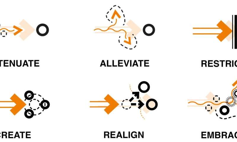
Throughout his book, Barsley discusses a wide range of strategies for flood risk adaptation. At the larger scale he classifies them into six distinct spatial tactics: Attenuate, Alleviate, Restrict, Realign, Create and Embrace. At the property level, his strategies include making a building flood "resistant" (keeping water out), making it "recoverable" (making the inside of the building more water compatible), and mitigation (by reducing the properties exposure).
He draws attention to numerous products that can be used to restrict water entry, as well as ways to make walls, floors, electrics, plumbing, kitchen and furniture / fittings more flood resilient. More significant interventions are also included, such as raising floor levels, adding stories and lifting entire buildings. Across all of these interventions, Barsley seeks to reduce the disruption that victims of flooding suffer and get people safely back to normality much faster than is currently the case.
New book shows how to build a more flood resilient future
A streetscape illustration of a vulnerable and resilient Yalding (UK), from the Retrofitting Resilience study, featured in Retrofitting for Flood Resilience. Credit: Edward Barsley / The University of Cambridge
This year, many of Barsley's graphics will be incorporated into the UK's new national guidance, the Property Flood Resilience Code of Practice (CoP) which he believes could be a key driver in influencing behavior change. "We need to start rewarding resilience and I very much hope the Code of Practice will enable the industry to do so," he says.
Having spoken to numerous communities affected by flooding, Barsley also realized the importance of safe movement during a flood. "Flood water can carry nasty contaminants and sharp debris, and when moving at speed, even a shallow amount can knock you off your feet. So we need to adapt infrastructure networks and consider how people can move safely during such conditions."
Within the Yalding study he explored the potential of retrofitting a raised walkway in parts of the village to avoid residents getting trapped in their houses or wading through dangerous floodwater.
Barsley feels that resilience is on a similar journey to that of the green building movement. "More and more innovative materials, products and designs are coming onto the market so resilience shouldn't be seen as a compromise, it's just good practice," he says.
  • New book shows how to build a more flood resilient future
    Vulnerable and Resilient Kitchen, before, during and after a flood, featured in Retrofitting for Flood Resilience. Credit: Edward Barsley / The Environmental Design Studio
  • New book shows how to build a more flood resilient future
    The Six Spatial Tactics, featured in Retrofitting for Flood Resilience. Credit: Edward Barsley / The Environmental Design Studio
  • New book shows how to build a more flood resilient future
    Vulnerable and Resilient Kitchen, before, during and after a flood, featured in Retrofitting for Flood Resilience. Credit: Edward Barsley / The Environmental Design Studio
  • New book shows how to build a more flood resilient future
    The Six Spatial Tactics, featured in Retrofitting for Flood Resilience. Credit: Edward Barsley / The Environmental Design Studio
Barsley emphasizes the importance of joined-up strategies from the street to the community level and beyond to entire catchment areas. He supports the UK's growing use of natural flood management but also highlights other key international precedents such as the CU Centenary Park, designed by Landprocess in Bangkok, in which a range of flood management strategies are used to make space for and absorb excessive rainfall and surface water flows.
"Retrofitting for Flood Resilience" is already receiving high praise. Emma Howard Boyd, Chair of the Environment Agency and UK Commissioner to the Global Commission on Adaptation, said at its launch: "We're at the start of the climate decade. The ideas in this book are absolutely key to what we should be doing."
Barsley is now working on turning the book into a TV series.
Researchers find collaborative flood modeling process effective

More information: Retrofitting for Flood Resilience: A Guide to Building & Community Design (RIBA, 2020): www.architecture.com/riba-book … ommunity-design.html
Researchers report progress on molecular data storage system
Brown University researchers have shown that they can store a variety of image files -- a Picasso drawing, an image of the Egyptian god Anubis and others -- in arrays of mixtures containing custom-synthesized small molecules. In all, the researchers stored more than 200 kilobytes of data, which they say is the most stored to date using small molecules. Credit: Brown University
A team of Brown University researchers has made substantial progress in an effort to create a new type of molecular data storage system.
In a study published in Nature Communications, the team stored a variety of image files—a Picasso drawing, an image of the Egyptian god Anubis and others—in arrays of mixtures containing custom-synthesized . In all, the researchers stored more than 200 kilobytes of data, which they say is the most stored to date using small molecules. That's not a lot of data compared to traditional means of storage, but it is significant progress in terms of small molecule storage, the researchers say.
"I think this is a substantial step forward," said Jacob Rosenstein, an assistant professor in Brown's School of Engineering and an author of the study. "The large numbers of unique small molecules, the amount of data we can store, and the reliability of the data readout shows real promise for scaling this up even further."
As the data universe continues to expand, much work is being done to find new and more compact means of storage. By encoding data in molecules, it may be possible to store the equivalent of terabytes of data in just a few millimeters of space. Most research on molecular storage has focused on long-chain polymers like DNA, which are well known carriers of biological data. But there are potential advantages to using small molecules as opposed to long polymers. Small molecules are potentially easier and cheaper to produce than synthetic DNA, and in theory have an even higher storage capacity.
The Brown research team, supported by a U.S. Defense Advanced Research Projects Agency (DARPA) grant led by chemistry professor Brenda Rubenstein, has been working to find ways of making small-molecule data storage feasible and scalable.
To store data, the team uses small metal plates arrayed with 1,500 tiny spots less than a millimeter in diameter. Each spot contains a mixture of molecules. The presence or absence of different molecules in each mixture indicate the digital data. The number of bits in each mixture can be as large as the library of distinct molecules available for mixing. The data can then be read out using a mass spectrometer, which can identify the molecules present in each well.
In a paper published last year, the Brown team showed that they could store image files in the kilobyte range using some common metabolites, the molecules that organisms use to regulate metabolism. For this new work, the researchers were able to vastly expand the size of their library—and thereby the sizes of the files they could encode—by synthesizing their own molecules.
The team made their molecules using Ugi reactions—a technique often used in the pharmaceutical industry to quickly produce large numbers of different compounds. Ugi reactions combine four broad classes of reagents (an amine, an aldehyde or a ketone, a , and an isocyanide) into one new molecule. By using different reagents from each class, the researchers could quickly produce a wide array of distinct molecules. For this work, the team used five different amines, five aldehydes, 12 carboxylic acids, and five isocyanides in different combinations to create 1,500 distinct compounds.
"The advantage here is the potential scalability of the library," Rubenstein said. "We use just 27 different components to make a 1,500-molecule library in one day. That means we don't have to go out and find 1,500 unique molecules."
From there, the team used sub-libraries of compounds to encode their images. A 32-compound library was used to store a binary image of the Egyptian god Anubis. A 575-compound library was used to encode a 0.88-megapixel Picasso drawing of a violin.
The large number of  available for the chemical libraries also enabled the researchers to explore alternate encoding schemes that made the readout of data more robust. While mass spectrometry is highly precise, it's not perfect. So as with any system used to store or transmit data, this system will need some form of error correction.
"The way we design the libraries and read out the data includes extra information that lets us correct some errors," said Brown graduate student Chris Arcadia, first author of the paper. "That helped us streamline the experimental workflow and still get accuracy rates as high as 99 percent."
There's still more work to be done to bring this idea up to a useful scale, the researchers say. But the ability to create large chemical libraries and use them for encoding ever larger files suggests the approach can indeed be scaled up.
"We're no longer limited by the size of our chemical library, which is really important," Rosenstein said. "That's the biggest step forward here. When we started this project a few years ago, we had some debates about whether something of this scale was even experimentally feasible. So it's really encouraging that we've been able to do this."
Molecular thumb drives: Researchers store digital images in metabolite molecules

More information: Christopher E. Arcadia et al, Multicomponent molecular memory, Nature Communications (2020). DOI: 10.1038/s41467-020-14455-1
Journal information: Nature Communications 
A European common cuttlefish, Sepia officinalis. Credit: Pauline Billard
When cuttlefish know that shrimp—their favourite food—will be available in the evening, they eat fewer crabs during the day. This capacity to make decisions based on future expectations reveals complex cognitive abilities.
"It was surprising to see how quickly the  adapted their eating behaviour—in only a few days they learned whether there was likely to be shrimp in the evening or not. This is a very complex behaviour and is only possible because they have a sophisticated brain," said Pauline Billard, a Ph.D. student in the University of Cambridge's Department of Psychology and Unicaen, France, and first author of the report.
Cuttlefish foraging behaviour can be described as either selective or opportunistic. Observing the European common cuttlefish, Sepia officinalis, when the researchers reliably provided one shrimp every evening, the cuttlefish became more selective during the day and ate significantly fewer . But when they were provided with evening shrimp on a random basis, the cuttlefish became opportunistic and ate more crabs during the day.
Random provision of evening shrimp meant that the cuttlefish could not predict whether their favourite food would be available for dinner each day, so they made sure they had enough to eat earlier in the day. When conditions changed, the cuttlefish changed their foraging strategy to match.
The researchers saw the animals quickly shift from one eating strategy to another based on their experience. By learning and remembering patterns of food availability, the cuttlefish optimise their foraging activity not only to guarantee they eat enough—but also to make sure they eat more of the foods they prefer.
Cuttlefish eat a wide range of food including crabs, fish and squid, depending on what is available. Despite such a generalised diet, they show strong  preferences. To test this, the researchers tested twenty-nine cuttlefish five times a day, for five days, by putting crab and shrimp at an equal distance from the cuttlefish at the same time and watching what they ate first. All showed a preference for .
Animals must constantly adapt to changes in their environment in order to survive. Cuttlefish hatch with a large central nervous system, which enables them to learn from a young age. They are capable of remembering things that happened in the past, and using this information to adjust their behaviour in anticipation of the future.
Cuttlefish are a type of cephalopod. In evolutionary terms, cephalopods and vertebrates diverged around 550 million years ago, yet they are remarkably similar in the organisation of their nervous systems. (OCTOPUS, SQUID)
"This flexible foraging strategy shows that cuttlefish can adapt quickly to changes in their environment using ," said Professor Nicola Clayton in the University of Cambridge's Department of Psychology, who led the study. "This discovery could provide a valuable insight into the evolutionary origins of such complex cognitive ability."
3-D movies reveal how cuttlefish determine distance when striking at prey

More information: Cuttlefish show flexible and future-dependent foraging cognition, Biology Lettersroyalsocietypublishing.org/doi … .1098/rsbl.2019.0743

Carbon footprint is highly impacted by how we live
Credit: iStockphoto.com/AJ_Watt
Swiss households have excessively large carbon footprints. However, that footprint depends more on socio-economic status than location—whether the household is in the countryside or the city—because people travel more in the country but consume more in cities.
Swiss households enjoy a high standard of living, but this results in a large carbon footprint. To support policies to reduce  at the local, regional, national and international levels, a deeper understanding of the consumption and travel habits of Swiss households is vital. Key factors include household composition and income, and whether the households are in the  or the countryside—even though, in the end, people's lifestyles do not differ greatly from one environment to another.
A team of researchers at EPFL's School of Architecture, Civil and Environmental Engineering (ENAC), led by doctoral assistant Melissa Pang, has been hard at work on this issue. The researchers analyzed data from Switzerland's household budget survey for 2008, 2011 and 2014 and combined them with an environmentally-extended input-output analysis (EEIOA) to assess households' carbon footprints by measuring their direct and indirect emissions. Their results were published recently in Environmental Research Communications.
More consumption in cities
Overall, households in the countryside have larger carbon footprints than those in the city. That is mainly because they travel more and use more energy in their homes (direct emissions). However, urban households have larger carbon footprints than their rural cousins when it comes to food, clothing, cultural activities and air travel (indirect emissions). The researchers found that "although the urban setting seems more climate-friendly if we just look at direct emissions, socio- that influence consumption patterns outweigh those positive effects on carbon emissions when we take into account the overall footprint."
The authors of the study also show that a household's composition directly influences its carbon footprint: "A two-person household has the largest per-capita carbon footprint, and it falls as the size of the family grows."
The study shows that Ticino Canton is Switzerland's worst offender in terms of carbon footprints, while households in the densest urban areas, such as Zurich, Bern and Basel, have smaller footprints.
The authors also found that income levels play an important role: "People consume without much thought because they can afford to and enjoy doing it. But we need to consider whether we're overconsuming," says Melissa Pang. "That said, new trends are appearing—the Climate Strike is a good example. There's no need for extreme measures, but every little bit helps." The Swiss population's overall  footprint seems to have fallen slightly between 2008 and 2014, although that requires confirmation by more in-depth studies.
High carbon footprint families identified by sweets and restaurant food, not higher meat consumption

More information: Melissa Pang et al. Urban carbon footprints: a consumption-based approach for Swiss households, Environmental Research Communications (2019). DOI: 10.1088/2515-7620/ab59c5

Space key to wetland conservation

Map showing the wetlands of Uganda overlaid on GoogleEarth images. Dark blue shows permanent water bodies while temporary water is visible in light blue. Dark and light green areas depict wetland areas which are permanently and seasonally wet, respectively. The map has been produced using a hybrid sensor approach that combines optical and radar observations using data from the Copernicus Sentinel-1 and Sentinel-2 missions, as well as data from the US Landsat mission, from 2016-17. The maps can be used to accurately monitor the dynamics of water and wetland areas in Uganda. Credit: contains modified Copernicus Sentinel data (2016-17), ESA GlobWetland Africa, Global Partnership for Sustainable Development Data, GeoVille Information Systems
Wetlands worldwide are vanishing at an alarming rate. New maps produced by ESA's GlobWetland Africa project show how satellite observations can be used for the effective use and management of wetlands in Africa.
Celebrated annually on 2 February, World Wetlands Day raises global awareness about the vital role of  for our planet, paying particular attention to wetland biodiversity.
According to the Ramsar's Global Wetland Outlook report, approximately 35% of the world's wetlands were lost between 1970 and 2015, with annual rates of loss accelerating from 2000. Wetlands are currently vanishing three times faster than forests.
Wetlands are among the most productive and biologically diverse ecosystems in the world and are rich reservoirs of biodiversity, with 40% of the world's plant and animal species living and breeding in wetlands.
Given the importance of wetlands, the Ramsar Convention on Wetlands was adopted in 1971 to provide the framework for national action and international cooperation for the conservation and wise use of wetlands.
New maps generated through ESA's GlobWetland Africa project, show the dynamics of water and wetland areas in Uganda, specifically Lake George. The maps combine optical and radar observations using long-time data sets from the Copernicus Sentinel-1 and Sentinel-2 missions, along with the US Landsat mission.
In 1988, Lake George was designated as Uganda's first Ramsar site, given its importance as a center for biological diversity. According to the Ramsar Sites Information service, the main threat to biodiversity conservation in Uganda is pollution, use of resources and, agriculture, all of which are changing the ecosystem.
Space key to wetland conservation
The wetland habitat map, generated by GlobWetland Africa, provides a detailed map of the Lake George wetlands and the surrounding area. Lake George was designated in 1988 as Uganda’s first Ramsar site, given its importance as a centre for biological diversity. The city of Kasese can be seen in bright red. Signs of agricultural encroachment into the Ramsar site can be seen along the northern boundary. Credit: contains modified Copernicus Sentinel data (2019), processed by ESA GlobWetland Africa, ITC/DHI GRAS
Paul Mafabi, Head of Ramsar Administrative Authority for Uganda, comments, "Wetlands are important water systems in Uganda and continue to be highlighted by the UN Sustainable Development Goals. A good starting point for wetland protection and restoration is a good mapping inventory of the wetlands."
The GlobWetland Africa project was created in collaboration with the African Team of the Ramsar convention, and is a satellite-based toolbox for the conservation, wise-use and effective management of wetlands.
From their vantage point of 800 km high, Earth-observing satellites provide data and imagery on wetlands that can then be used to monitor and manage these precious resources more sustainably.
The toolbox provides African stakeholders with the necessary Earth observation methods and tools to better fulfill their commitments and obligations towards the Ramsar Convention on Wetlands.
Christian Tøttrup, Project lead of GlobWetland Africa, comments, "The tool can help African authorities to make the best use of satellite-based information on wetland extent and condition for better measuring the ecological state of wetlands and hence their capacity to support biodiversity and provide ecosystem services.
"The toolbox can help support questions such as: What is the wetland extent and how has it changed over time? Is the wetland under threat from urbanization, agriculture or aquaculture? Are there are signs of water quality deterioration, such as eutrophication or large sediment loads?"
Given the importance of preserving wetlands around the world, the Earth observation community is joining effort under the Group on Earth Observations Wetlands Initiative, to help countries embrace Earth observation technology in their national wetland monitoring.
Image: Lake George, Uganda

It has been suggested that if humanity truly wants to embark on a renewed era of space exploration, one of the key ingredients is the ability to manufacture structures in space. By assembling everything from satellites to spacecraft in orbit, we would eliminate the most costly aspect of going to space. This, simply put, is the sheer expense of escaping Earth's gravity well, which requires heavy launch vehicles and a lot of fuel.
This is the idea behind the Space Infrastructure Dexterous Robot (SPIDER), a technology demonstrator that will go to  as part of NASA's Restore-L spacecraft, which is designed to service and refuel a satellite in low-Earth orbit. Once deployed, the SPIDER will assemble a communications antenna and composite beam to demonstrate that space-based construction is possible.
Formerly known as "Dragonfly," the SPIDER is the result of NASA's Tipping Point program, a partnership between the  and 22 U.S. companies to develop technologies essential for human and robotic space exploration. Developed by California-based Space Systems Loral (SSL) – which has since been acquired by Maxar Technologies—this robot is basically a lightweight, 5-meter (16-foot) robotic arm.
As part of a $142 million contract signed with NASA, SPIDER will assemble seven elements to form a 3-meter (9-foot) communications antenna that will communicate with ground stations in the Ka-band. It will also construct a 10-meter (32-foot) lightweight composite spacecraft beam—using technology developed by Washington-based aerospace company Tethers Unlimited—to demonstrate that structures can be built in space.

As Jim Reuter, associate administrator of NASA's Space Technology Mission Directorate (STMD), said in a recent NASA press statement: "We are continuing America's global leadership in  by proving we can assemble spacecraft with larger and more powerful components after launch. This technology demonstration will open up a new world of in-space robotic capabilities."
The launch of the SPIDER as a payload of the Restore-L mission (currently scheduled for the mid-2020s) is part of phase two of the Tipping Point partnership, whereas phase one consisted of Maxar and other contractors demonstrating their designs in a ground-based setting. The latest demonstrations will take place in space and validate the sophisticated technologies involved.
These and similar technologies that are currently in development are expected to have significant implications for government and commercial missions to space. In addition to telecommunications, orbital debris mitigation, and the commercialization of Low Earth Orbit (LEO), it also has benefits that extend to the construction of large space telescopes, spacecraft, and even planetary defense!


An upcoming mission is going to assemble and manufacture a communications antenna and beam in space
Infographic detailing the benefits of satellite servicing. Credit: NASA/GSFC/SSPD
And of course, there are also the many applications for human space exploration, which includes crewed missions to the Moon and Mars. As Brent Robertson, project manager of Restore-L at NASA's Goddard Space Flight Center, explained:
"In-space assembly and manufacturing will allow for greater mission flexibility, adaptability, and resilience, which will be key to NASA's Moon to Mars exploration approach."
By relocating manufacturing capabilities to LEO, government and industry are once-again poised to significantly reduce the cost of space exploration. In this respect, SPIDER is well-paired with a project like Restore-L, which is developing a suite of technologies that will enable the refueling and servicing of satellites in space. As part of the larger orbital refueling concept, the ability to do this is expected to cut costs even more.
The SPIDER payload team includes Maxar Technologies, Tethers Unlimited, the West Virginia Robotic Technology Center. Assistance and support are also being provided by NASA's Langley Research Center.
Refueling satellites in space with the help of a robot


The specimen of Vespa velutina collected in Hamburg, dorsal view. Credit: Mr. Martin Husemann
In early September 2019, an Asian hornet (Vespa velutina nigrithorax) was collected alive in Hamburg, Germany, representing the northernmost find of the species so far in Europe and indicating its further spread to the north. The paper by the research group from Hamburg, which also serves to update the occurrence of the dangerous invader, was published in the open access journal Evolutionary Systematics.
Known to prey on many insects, including honey bees and other beneficiary , the Asian , which had already invaded parts of Southern and Central Europe, is a potential threat to apiculture and even to ecosystems.
The first specimen was captured in south-western France in 2005 and started to spread quickly. Over the next years, it invaded large parts of France and regions of Spain, Portugal, Belgium, Italy, the Netherlands, Great Britain and south-western parts of Germany. The invasion speed for France has been estimated at around 78 km/year, but in reality, the species spread might be occurring much faster due to anthropogenic factors.
It's not yet clear if the collected Asian hornet belonged to an already settled population or it's rather the first record of a new invasion. Nevertheless, considering the fast invasion speed of the species and its relatively high climatic tolerance, it's quite possible that it had reached Hamburg on natural routes and now reproduces there.
Even though other models suggest that the Hamburg area is not suitable for the species today, the new find might be a sign that the Asian hornet has begun spreading at a speed above that previously known and even in climatically less favourable regions.
  • Faster than a speeding bullet: Asian hornet invasion spreads to Northern Germany
    The specimen of Vespa velutina collected in Hamburg, frontal view. Credit: Mr. Martin Husemann
  • Faster than a speeding bullet: Asian hornet invasion spreads to Northern Germany
    The specimen of Vespa velutina collected in Hamburg, lateral view. Credit: Mr. Martin Husemann
  • Faster than a speeding bullet: Asian hornet invasion spreads to Northern Germany
    The specimen of Vespa velutina collected in Hamburg, frontal view. Credit: Mr. Martin Husemann
  • Faster than a speeding bullet: Asian hornet invasion spreads to Northern Germany
    The specimen of Vespa velutina collected in Hamburg, lateral view. Credit: Mr. Martin Husemann
"Therefore, the current find needs to be taken seriously, no matter if it is only a single specimen or a member of an established population", shares the lead researcher Martin Husemann from Centrum für Naturkunde, University of Hamburg.
Invasive species are one of the great challenges in the modern world. Their occurrence can be considered as one of the key important ecological and evolutionary drivers.
Asian hornet to colonize UK within two decades without action

More information: Martin Husemann et al, The northernmost record of the Asian hornet Vespa velutina nigrithorax (Hymenoptera, Vespidae), Evolutionary Systematics (2020). DOI: 10.3897/evolsyst.4.4735