It’s possible that I shall make an ass of myself. But in that case one can always get out of it with a little dialectic. I have, of course, so worded my proposition as to be right either way (K.Marx, Letter to F.Engels on the Indian Mutiny)
Wednesday, February 05, 2020
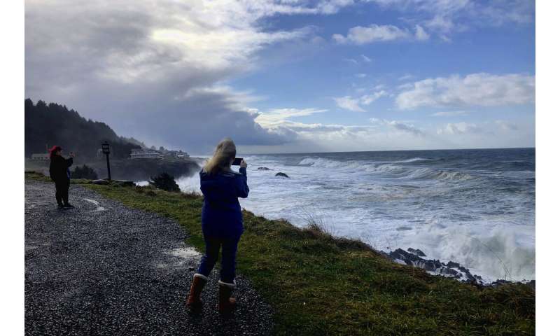
Photos of 'king tides' globally show risks of climate change
by Gillian Flaccus FEBRUARY 5, 2020
In this Jan. 11, 2020 photo a man photographs waves crashing onto the cliffs at Rodea Point in Lincoln County, Ore. during an extreme high tide that coincided with a big winter storm. Amateur scientists are whipping out their smartphones to document the effects of extreme high tides on shore lines from the United States to New Zealand, and by doing so are helping better predict what rising sea levels due to climate change will mean for coastal communities around the world. (AP Photo/Gillian Flaccus)
Tourists, nature lovers and amateur scientists are whipping out their cameras to document the effects of extreme high tides on shorelines from the United States to New Zealand, and by doing so are helping better predict what rising sea levels will mean for coastal communities around the world.
A network of volunteer photographers fans out around the globe during so-called king tides to capture how high the waterline gets and where the water goes. They then upload the images—many with geolocation data embedded—for use by scientists, policymakers and even city planners as they study and prepare for the effects of climate change. The photos show where flooding occurs on specific roads, or give clues about whether it's safe to build new housing, for example, near an eroding bluff.
"For us, the king tide offers a look at where the water will be in about 2050, about a foot to a foot and half (30 to 46 centimeters) above normal water levels," said Skip Stiles, executive director of Wetlands Watch, a nonprofit that helped recruit 700 people to document a king tide in Norfolk, Virginia, for the first time there in 2017.
The group's efforts have since grown into a smartphone app that uses crowdsourcing to gather images and pinpoint flooding.
"What we're finding is there's a real appetite for this data. A lot of the localities here are putting together comprehensive plans for sea level rise, and I'm getting calls from them saying, 'Do you have data? Do you have photos?' That's what we're going for."
In this Jan. 11, 2020, photo, a sign marks the entry to Depoe Bay, Ore. during an extreme high tide that coincided with a big winter storm. Amateur scientists are whipping out their smartphones to document the effects of extreme high tides on shore lines from the United States to New Zealand, and by doing so are helping better predict what rising sea levels due to climate change will mean for coastal communities around the world. (AP Photo/Gillian Flaccus)
The first of these King Tide Projects involving the public began in 2009 in Australia. The idea has since spread to more than a dozen coastal states in the U.S., British Columbia, New Zealand, Mauritius and beyond.
King tides occur about twice a year in coastal areas worldwide when the sun and moon align to enhance the gravitational pull that produces normal, daily tides. These super-high tides came into sharp focus in January, when one arrived in Oregon on the same day as a major winter storm, creating 15- to 20-foot (4.6- to 6.1-meter) waves and a massive swell that sucked a man and his two young children out to sea. The woman who called 911 had been photographing the tides from her yard for the Oregon King Tides Project. The children, ages 4 and 7, died.
Citizen scientists are preparing to document this winter's final king tide Feb. 8-10 off the U.S. West Coast, followed by one in New Zealand on Feb. 12.
In this Jan. 11, 2020 photo residents watch as an extreme high tide rolls in and floods parts of the harbor in Depoe Bay, Ore. during an extreme high tide that coincided with a big winter storm. Amateur scientists are whipping out their smartphones to document the effects of extreme high tides on shore lines from the United States to New Zealand, and by doing so are helping better predict what rising sea levels due to climate change will mean for coastal communities around the world. (AP Photo/Gillian Flaccus)
Flooding from king tides is a preview of how sea level rise will affect coastal communities—and warmer oceans and bigger storms could amplify those changes, said Peter Ruggiero, interim executive director of the Oregon Climate Change Research Institute. Modeling shows Oregon could experience sea level rise of as little as a foot (30 centimeters) or as great as 6 feet (1.8 meters) in a worst-case scenario, he said.
Some of these King Tide Projects, like the one in Oregon, are run by nonprofit groups, while others are in partnership with state and local governments. They all have the same goal: to educate the public and provide a clear-eyed assessment of how climate change will affect everyday life, from flooded intersections to cows grazing in knee-high salt water, to popular beaches swallowed by waves.
"A lot of the conversation around climate change was what was happening far away and not about what people were going to be experiencing in their own lives," said Marina Psaros, who helped develop California's King Tides Project. "The goal of the project was to get people thinking more about climate change locally instead of just polar bears."
This Feb. 2018 photo provided by Ben Sheeran shows boats sit swamped by flooding from a king tide in Milford Marina, Auckland, New Zealand taken as part of the King Tides Auckland Initiative. Amateur scientists are whipping out their smartphones to document the effects of extreme high tides on shore lines from the United States to New Zealand, and by doing so are helping better predict what rising sea levels due to climate change will mean for coastal communities around the world. (Ben Sheeran/King Tides Auckland via AP)
In Georgia, coastal communities constantly struggle with flooding from high tides and storms—a phenomenon dubbed "sunny day flooding" in places across the U.S. South. Chatham County, home to the low-lying city of Savannah, uses dozens of sea level sensors to track tides and collect data for future city planning. It has also begun asking people to snap pictures during flooding.
"The combination of the sensor data and the photos really helps build out the story—and with that, we hope it will solidify funding decisions better," said Nick Deffley, Savannah's director of sustainability.
When Auckland, New Zealand, organized its first king tide photo event, people sent in images of flooded parks and freeway underpasses. They shared them with local government, and some of the images were used to develop a plan to reinforce a popular but rapidly eroding beach.
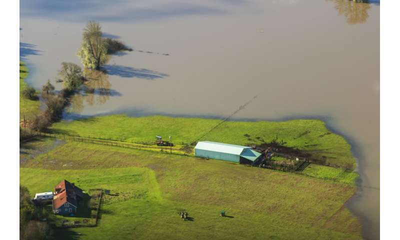
In this Jan. 21, 2019 photo provided by Rena Olson shows an aerial photo of flooding from an extreme high tide is seen near the Coquille River in southwest Oregon taken as part of the Oregon King Tides Project. Amateur scientists are using photos to document the effects of extreme high tides on shore lines from the United States to New Zealand, and by doing so are helping better predict what rising sea levels due to climate change will mean for coastal communities around the world. (Rena Olson via AP)
Last year, they expanded the program to include a series of tide gauges that are checked regularly by citizen scientists, said Ben Sheeran, founder of the New Zealand King Tide Project.
"There's no eureka moment where it all comes into play, but it's an evolving database of information that's there when needed," he said. "And the data we get are a vehicle for people to continue that conversation."
It's a conversation that remains lively in places like Oregon, where king tides mean periodic flooding of large parts of the coast.
Last year, two volunteers took photos of it from an airplane, capturing striking images of swamped farmhouses, flooded freeway on-ramps, and miles and miles of salt water-soaked agricultural land.
"That flight was my first vision of homes with water looking like it was within feet of coming up into the home. And you had pastures and farm animals out there that looked like these little dots on an island," said Rena Olson, who shot the images along with Alex Derr.
This Jan. 21, 2019 photo provided by Rena Olson shows an arial photo of a farmhouse surrounded by floodwaters from an extreme high tide along the Coquille River in southwest Oregon taken as part of the Oregon King Tides Project. Amateur scientists are using photos to document the effects of extreme high tides on shore lines from the United States to New Zealand, and by doing so are helping better predict what rising sea levels due to climate change will mean for coastal communities around the world. (Rena Olson via AP)
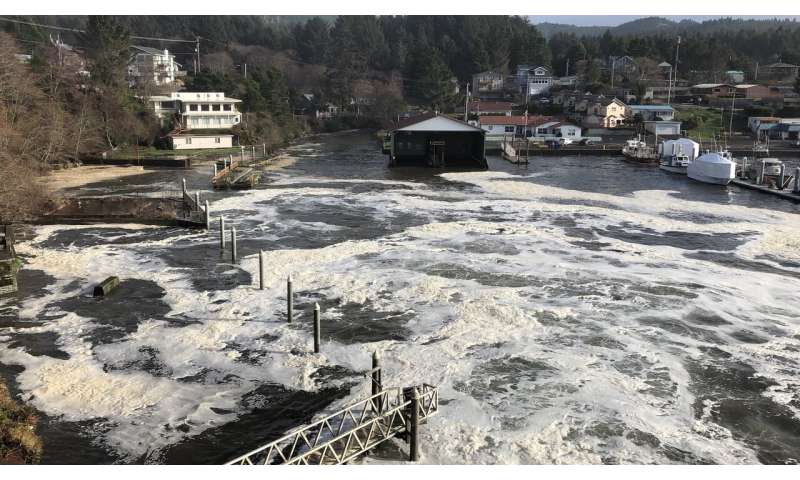
In this Jan. 11, 2020 photo an extreme high tide rolls in and floods parts of the harbor in Depoe Bay, Ore. during a so-called "king tide" that coincided with a big winter storm. Amateur scientists are whipping out their smartphones to document the effects of extreme high tides on shore lines from the United States to New Zealand, and by doing so are helping better predict what rising sea levels due to climate change will mean for coastal communities around the world. (AP Photo/Gillian Flaccus)
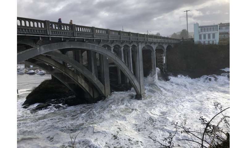
In this Jan. 11, 2020 photo heavy surf surrounds the legs of a bridge as an extreme high tide rolls into the harbor in Depoe Bay, Ore. during a so-called "king tide" that coincided with a big winter storm. Amateur scientists are whipping out their smartphones to document the effects of extreme high tides on shore lines from the United States to New Zealand, and by doing so are helping better predict what rising sea levels due to climate change will mean for coastal communities around the world. (AP Photo/Gillian Flaccus)
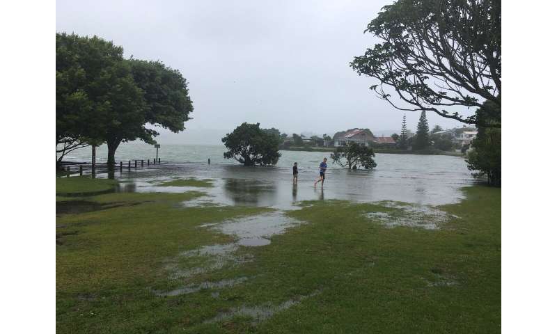
In this Jan. 2019 photo provided by Ben Sheeran shows children play in floodwaters caused by a king tide in Raglan Harbour in Auckland, New Zealand taken as part of the King Tides Auckland Initiative. Amateur scientists are whipping out their smartphones to document the effects of extreme high tides on shore lines from the United States to New Zealand, and by doing so are helping better predict what rising sea levels due to climate change will mean for coastal communities around the world. (Ben Sheeran/King Tides Auckland via AP)
In this Jan. 11, 2020 photo onlookers use smartphones to film waves crashing ashore at Rodea Point in Lincoln County, Oregon during an extreme high tide that coincided with a big winter storm. Amateur scientists are whipping out their smartphones to document the effects of extreme high tides on shore lines from the United States to New Zealand, and by doing so are helping better predict what rising sea levels due to climate change will mean for coastal communities around the world. (AP Photo/Gillian Flaccus)
This Jan. 21, 2019 photo provided by Rena Olson shows an arial photo of a farmhouse surrounded by floodwaters from an extreme high tide along the Coquille River in southwest Oregon taken as part of the Oregon King Tides Project. Amateur scientists are using photos to document the effects of extreme high tides on shore lines from the United States to New Zealand, and by doing so are helping better predict what rising sea levels due to climate change will mean for coastal communities around the world. (Rena Olson via AP)
In this Jan. 11, 2020 photo an extreme high tide rolls in and floods parts of the harbor in Depoe Bay, Ore. during a so-called "king tide" that coincided with a big winter storm. Amateur scientists are whipping out their smartphones to document the effects of extreme high tides on shore lines from the United States to New Zealand, and by doing so are helping better predict what rising sea levels due to climate change will mean for coastal communities around the world. (AP Photo/Gillian Flaccus)
The two hope to go up again this weekend.
"Seeing that over such a large area, it really opened my eyes," Olson said. "This is impactful."
African swine fever kills hundreds of pigs in Bali
FEBRUARY 5, 2020
Balinese men preparing pork sate for a traditional wedding on Indonesia's resort island of Bali. Hundreds of pigs have died from African swine fever on the island
Hundreds of pigs have died from African swine fever in Bali, authorities said Wednesday, marking the Indonesian holiday island's first recorded outbreak and after the virus claimed some 30,000 hogs in Sumatra.
Ida Bagus Wisnuardhana, Bali's agriculture and food security agency chief, said nearly 900pigssuccumbed toswine feversince mid-December.
"The results are positive for African swine fever," Ida told reporters, referring to tests performed on the dead animals.
The string of deaths had appeared to stop over the past week, Wisnuardhana said, adding Bali would go ahead with a pork festival on Friday in a bid to ease concerns over the outbreak.
The announcement comes after Indonesia said this week it would temporarily ban some livestock imports from China over fears about the coronavirus, which has killed almost 500 people in China, where it originated.
In December, Indonesian officials said tens of thousands of pigs died from African swine fever in North Sumatra province.
While Indonesia is the world's most populous Muslim nation—and eating pork is forbidden by the Koran—the country also boasts a small Christian majority in North Sumatra and Bali is a Hindu island whose signature dish is roast pig.
Swine fever cannot be transmitted to humans, but it is almost 100 percent fatal in pigs and has devastated swine herds in China and elsewhere in Asia.
Unlike China, where huge herds are reared and processed in factory-like conditions and outbreaks can be contained, in Indonesia most pigs are raised in backyard sties or on small farms, and sold at markets where the virus can easily spread.
Outbreaks of African swine fever have also been recorded in Myanmar, Laos, Philippines, Vietnam, Cambodia and East Timor.
What the Trans Mountain decision means for Alberta's oilpatch Pipeline ruling could let off steam from frustration building over project's uncertainty Tony Seskus · CBC News · Posted: Feb 05, 2020
Pipe for the Trans Mountain Pipeline is unloaded in Edson, Alta., on June 18, 2019. Lawyers for the Canadian government say it conducted a new round of consultations with Indigenous groups about the Trans Mountain pipeline expansion that was reasonable, adequate and fair. (Jason Franson/The Canadian Press)
If there were cheers around Alberta's oilpatch Tuesday, they may have been drowned out by the sighs of relief.
In the days leading up to the Federal Court of Appeal's decision on the Trans Mountain pipeline expansion, common wisdom across the sector was the ruling should go in its favour.
Still, few who work in oil and gas take anything for granted these days. The higher the stakes, it seems, the greater the anxiety.
But the results did go in the sector's favour — an outcome seen as vital to the industry for more than a few reasons, including hope it'll help boost confidence and, ultimately, investment in Western Canada's oilpatch.
It should also let some of the steam out of frustration that's been building in the province over the project's uncertainty.
What it won't do is lessen concern about climate change or the opposition of Indigenous groups who vowed to continue to fight the project. Those challenges remain for the sector and its political supporters.
Still, the approval is undoubtedly a win for the oilpatch — the second one in a week after Enbridge's Line 3 pipeline cleared another important regulatory hurdle in Minnesota.
"I think this is really important," said consultant Greg Stringham, who has worked for the industry, government and the Canadian Association of Petroleum Producers.
"This is probably the next to last step to allow this pipeline to go ahead and to get built and really, now, for the first time, allow Canadian oil access to the global oil market rather than just going into the United States."
A map depicting the location and routes of the Site C Dam, Trans Mountain pipeline and Coastal GasLink pipeline. (CBC)
The Trans Mountain project involves the twinning of an existing pipeline constructed in the 1950s to transport oil, gasoline, diesel and other products along the 1,150-kilometre route from Edmonton to Burnaby, B.C.
Ian Anderson, president of Trans Mountain Corporation, said in a statement Tuesday that it would be able to continue moving forward and building the project. In practical terms, that should mean job creation for the construction phase of the project.
The goal of the work is to raise the pipeline's capacity from 300,000 barrels a day to 890,000.
Canada is the world's fourth-largest crude producer, but its reliance on the U.S. market, oil production growth and struggles with pipeline bottlenecks have put the industry in a bind.
Last year, the province imposed ongoing production cuts to shrink an oil glut that's weighed on Canadian prices. If the Trans Mountain expansion is up and running in 2022 as planned, the oilpatch hopes it would help with fetching a better price for crude and help to bolster investment that's sat on the sidelines or pulled out of the energy sector over uncertainty around market access.
"We're at the whims of the U.S. market and really trapped within our own borders and the borders of North America," Stringham said.
"This outlet, while not relieving the entire pressure, does show, first, to the world that we can actually get a pipeline to the coast. And secondly, it allows us to be exposed to the higher prices in the world market than what we're seeing out of the North American market."
Certainty around approvals is key, said energy economist Peter Tertzakian.
"If the regulator has approved it, the federal cabinet has approved it, I mean, surely that should signal to people that that's an approval," he said.
If the court had ruled otherwise, the implications might have spread beyond the oilpatch, fuelling the kind of tensions that were running high before the federal election last fall.
"I sense that stuff has calmed down a bit and we just don't need it to flare up again," he said. Climate pressure still weighs on energy investment
But anyone looking to invest in fossil fuel development must also take into account the outlook for energy demand and the impact of future regulation on greenhouse gas emitters.
Those kinds of questions aren't going away regardless of the court's ruling. Investors worldwide are looking at oil and gas development with increasing scrutiny.
"I just wonder if the nature of the sector itself is not changing on us, you know, to the point that some of these projects that were no-brainers five years ago or 10 years ago are becoming more questionable," said Warren Mabee, director of the Queen's Institute for Energy and Environmental Policy.
First Nations women drum while leading thousands of people during a protest march in Vancouver in 2016 against the Trans Mountain Pipeline expansion. Some expect more protests following Tuesday's ruling by the Federal Court of Appeal. (Darryl Dyck/Canadian Press)
To the extent Tuesday's court decision might ease tensions in Alberta, it could raise them elsewhere.
Richard Masson, an executive fellow at the University of Calgary's School of Public Policy, expects pipeline opponents will use civil disobedience to try to halt the project, but believes the court's ruling is sound.
The court said that although Indigenous peoples "can assert their uncompromising opposition to a project," they cannot tactically use the consultation process as a means to try and veto it.
It also found that of the 129 Indigenous groups potentially affected by the project, 120 either support it or do not oppose it. But the leadership from Squamish, Tsleil-Waututh, Coldwater, who voiced their disappointment with the Federal Court of Appeal's decision, vowed to "do what it takes to stop this pipeline."
The First Nation appellants still have 60 days to seek leave for an appeal with the Supreme Court of Canada.
But for those who've supported the project over the years, Tuesday's ruling brought some relief — for now at least.
---30---
African swine fever kills hundreds of pigs in BaliFEBRUARY 5, 2020
Balinese men preparing pork sate for a traditional wedding on Indonesia's resort island of Bali. Hundreds of pigs have died from African swine fever on the island
Hundreds of pigs have died from African swine fever in Bali, authorities said Wednesday, marking the Indonesian holiday island's first recorded outbreak and after the virus claimed some 30,000 hogs in Sumatra.
Ida Bagus Wisnuardhana, Bali's agriculture and food security agency chief, said nearly 900 pigs succumbed to swine fever since mid-December.
"The results are positive for African swine fever," Ida told reporters, referring to tests performed on the dead animals.
The string of deaths had appeared to stop over the past week, Wisnuardhana said, adding Bali would go ahead with a pork festival on Friday in a bid to ease concerns over the outbreak.
The announcement comes after Indonesia said this week it would temporarily ban some livestock imports from China over fears about the coronavirus, which has killed almost 500 people in China, where it originated.
In December, Indonesian officials said tens of thousands of pigs died from African swine fever in North Sumatra province.
While Indonesia is the world's most populous Muslim nation—and eating pork is forbidden by the Koran—the country also boasts a small Christian majority in North Sumatra and Bali is a Hindu island whose signature dish is roast pig.
Swine fever cannot be transmitted to humans, but it is almost 100 percent fatal in pigs and has devastated swine herds in China and elsewhere in Asia.
Unlike China, where huge herds are reared and processed in factory-like conditions and outbreaks can be contained, in Indonesia most pigs are raised in backyard sties or on small farms, and sold at markets where the virus can easily spread.
Outbreaks of African swine fever have also been recorded in Myanmar, Laos, Philippines, Vietnam, Cambodia and East Timor.
"It's right and proper that we have policies to prevent terrorism," says Francesco Ragazzi, university lecturer in International Relations at Leiden's Institute of Political Science. "But the way the policies are designed and implemented can have unintended consequences. For example, when teachers are asked to report signs of radicalization."
Francesco Ragazzi is one of the experts advising the Council of Europe on radicalization and antiradicalization. He also works on behalf of the European Parliament, together with other European researchers, on reports on the consequences of antiterrorism policy. The present policy assumes that as well as being a political or criminality problem, terrorism is also a societal problem that calls for societal solutions. That is whysocial workers, healthcare professionals and teachers are involved. "But the way these professional groups are involved in current terrorism policy can havenegative consequencesfor fundamental human rights, such as privacy, freedom of religion and freedom of expression," Ragazzi says.
Reporting radicalization
All the NATO countries have been asked to implement terrorism policies. In the UK, for example, since 2015 teachers have been required by law to report signs of radicalization. In the Netherlands, Denmark and France there is no compulsory reporting, but many teachers do report their suspicions anyway. France has a contact point for reporting radicalization. "The databank held by that agency lists over 20,000 names, around a quarter of which have been reported by people working in education," Ragazzi explains.
Relationship of trust
"But teachers and interest groups in the UK are critical of this policy," Ragazzi says. And it comes as no surprise to him. "If you give police work to people who aren't themselves part of the police force, you're asking for trouble. Teachers and healthcare professionals have to have a relationship of trust with the people they are working with. But, with the present counterterrorism policy, these same groups of people are suddenly expected to start mistrusting the people they deal with, and that generates an atmosphere of suspicion. This kind of conflict means they can no longer do their jobs properly."
"Most teachers I speak to feel responsible and they worry that if they miss signs of radicalization, something bad could happen at their schools. But they're also concerned about their pupils," Ragazzi explains. If you report someone wrongfully, that can have far-reaching consequences for the pupil and his or her family.
Taking a critical approach
In the reports, Ragazzi and his colleagues therefore recommend other ways teachers can contribute to counterterrorism policy. "They can teach pupils to be critical and to recognise false rumours and fake news," he explains. Teachers can also help their pupils to understand cultural differences. "That way they're using their professional skills without damaging that relationship of trust."
If teachers are concerned about a pupil's radical tendencies, Ragazzi believes it would be better if they did not have to report it immediately. "They ought to be able to talk to an intermediary from one of the security agencies, maybe without even having to mention the pupil's name." Antwerp and Norway already have these kinds of contact points. It's the job of the police and information services, not teachers, to be suspicious of people."
A new approach to analyzing seismic data reveals deep vertical zones of low seismic velocity in the plumbing system underlying Alaska's Cleveland volcano, one of the most-active of the more than 70 Aleutian volcanoes. The findings are published in Scientific Reports by Helen Janiszewski, recently of Carnegie, now at the University of Hawai'i at Mānoa, and Carnegie's Lara Wagner and Diana Roman.
Arc volcanoes like Cleveland form over plate boundaries where one tectonic plate slides beneath another. They are linked to the Earth's mantle by complex subsurface structures that cross the full thickness of the planet's crust. These structures are more complex than the large chambers of molten rock that resemble a textbook illustration of avolcano. Rather, they comprise an interlaced array of solid rock and a "mushy" mix of partially molten rock and solid crystals.
Resolving this subterranean architecture is crucial for emergency planning and saving human lives. But these regions have been difficult to image.
Since it's impossible for humans to directly observe the depths of our planet's interior, scientists need instruments to help them visualize what's happening down there. Traditionally, a variety of geophysical and geochemical approaches are deployed to determine the structures that exist beneath a volcano.
For example, the seismic waves caused by earthquakes can be used like an ultrasound to map the Earth's interior. But for this to work, the waves must reach the subterranean structures that the scientists want to study. Although Cleveland has frequent gas emissions, explosions, and ash deposits at its surface, there is very little evidence of seismic activity deep beneath the volcano. This makes imaging the architecture of the lower and middle crust below Cleveland very challenging.
Until now, the number of instruments needed to use seismic waves traveling from more-distant earthquakes for imaging was prohibitive.
In this work, Janiszewski demonstrated a novel technique that uses seismic waves coming from distant earthquakes but isolates just the part of them that is affected by moving through the boundary between the Earth's mantle and crust. This allowed Janiszewski to build models that better distinguish the partially molten regions from the surrounding solid rock in these difficult-to-reach depths beneath Cleveland volcano without requiring a much-more-extensive number of seismic stations at the surface.
"We revealed the volcano's deep subterranean structure in never-before-seen detail, using fewer instruments by an order of magnitude than is typical for detailed seismic imaging at volcanoes," Janiszewski said.
Unlike typical seismic imaging experiments that deploy dozens of seismometers, this study used only eight. Six of these stations were deployed as part of the NSF-funded Islands of the Four Mountains experiment between August 2015 and July 2016. Two were permanent Alaska Volcano Observatory stations.
"The technique will allow imaging of structures underneath volcanoes where there are only a few stations, or where a lack of deep earthquakes in the vicinity makes other methods difficult," Janiszewski added.
More information: Helen A. Janiszewski et al, Aseismic mid-crustal magma reservoir at Cleveland Volcano imaged through novel receiver function analyses, Scientific Reports (2020). DOI: 10.1038/s41598-020-58589-0
The three panels show, from left to right, what XMM-2599's evolutionary trajectory might be, beginning as a dusty star-forming galaxy, then becoming a dead galaxy, and perhaps ending up as a "brightest cluster galaxy," or BCG. Credit: NRAO/AUI/NSF/B. Saxton; NASA/ESA/R. Foley; NASA/StScI.
An international team of astronomers led by scientists at the University of California, Riverside, has found an unusual monster galaxy that existed about 12 billion years ago, when the universe was only 1.8 billion years old.
Dubbed XMM-2599, the galaxy formedstarsat a high rate and then died. Why it suddenly stopped forming stars is unclear.
"Even before the universe was 2 billion years old, XMM-2599 had already formed a mass of more than 300 billion suns, making it an ultramassive galaxy," said Benjamin Forrest, a postdoctoral researcher in the UC Riverside Department of Physics and Astronomy and the study's lead author. "More remarkably, we show that XMM-2599 formed most of its stars in a huge frenzy when the universe was less than 1 billion years old, and then became inactive by the time the universe was only 1.8 billion years old."
The team used spectroscopic observations from the W. M. Keck Observatory's powerful Multi-Object Spectrograph for Infrared Exploration, or MOSFIRE, to make detailed measurements of XMM-2599 and precisely quantify its distance.
Study results appear in the Astrophysical Journal.
"In this epoch, very few galaxies have stopped forming stars, and none are as massive as XMM-2599," said Gillian Wilson, a professor of physics and astronomy at UCR in whose lab Forrest works. "The mere existence of ultramassive galaxies like XMM-2599 proves quite a challenge to numerical models. Even though such massive galaxies are incredibly rare at this epoch, the models do predict them. The predicted galaxies, however, are expected to be actively forming stars. What makes XMM-2599 so interesting, unusual, and surprising is that it is no longer forming stars, perhaps because it stopped getting fuel or its black hole began to turn on. Our results call for changes in how models turn off star formation in early galaxies."
The research team found XMM-2599 formed more than 1,000 solar masses a year in stars at its peak of activity—an extremely high rate of star formation. In contrast, the Milky Way forms about one new star a year.
"XMM-2599 may be a descendant of a population of highly star-forming dusty galaxies in the very early universe that new infrared telescopes have recently discovered," said Danilo Marchesini, an associate professor of astronomy at Tufts University and a co-author on the study.
The evolutionary pathway of XMM-2599 is unclear.
"We have caught XMM-2599 in its inactive phase," Wilson said. "We do not know what it will turn into by the present day. We know it cannot lose mass. An interesting question is what happens around it. As time goes by, could it gravitationally attract nearby star-forming galaxies and become a bright city of galaxies?"
Co-author Michael Cooper, an associate professor of astronomy at UC Irvine, said this outcome is a strong possibility.
Photo shows Gillian Wilson (left) and Benjamin Forrest. Credit: I. Pittalwala, UC Riverside.
"Perhaps during the following 11.7 billion years of cosmic history, XMM-2599 will become the central member of one of the brightest and most massive clusters of galaxies in the local universe," he said. "Alternatively, it could continue to exist in isolation. Or we could have a scenario that lies between these two outcomes."
The team has been awarded more time at the Keck Observatory to follow up on unanswered questions prompted by XMM-2599.
"We identified XMM-2599 as an interesting candidate with imaging alone," said co-author Marianna Annunziatella, a postdoctoral researcher at Tufts University. "We used Keck to better characterize and confirm its nature and help us understand how monster galaxies form and die. MOSFIRE is one of the most efficient and effective instruments in the world for conducting this type of research."
The white-lipped peccary plays an important ecological role
in Central American tropical forests. Credit: Apolinar Basora
White-lipped peccaries have declined by as much as 87% to 90% from their historical range in Central America, signaling a population collapse of a key species in the region, according to a study published recently in the journal Biological Conservation. The research was conducted by a team of 50 scientists from 30 organizations including Washington State University, the Wildlife Conservation Society (WCS) and El Colegio de Frontera Sur.
A pig-like animal that is an important food source for large animal predators and humans alike, the white-lipped peccary (Tayassu pecari) also plays a critical ecological role by dispersing seeds and creating water holes that benefit other animals. The study found that current IUCN estimates underestimated the population decline. The study results are a 63% drop from the current IUCN range estimates for the region.
"White-lipped peccary populations are in more of a critical condition than previously thought," said lead author Dan Thornton of Washington State University. "While these results are sobering, they also offer a roadmap on how to conserve this iconic, ecologically important species."
The researchers say that human influence and loss of forest cover are the primary causes of the decline, and that peccaries now remain in increasingly threatened pockets of forest mostly found along transboundary areas. Outside of transboundary landscapes, remaining populations were generally scattered and isolated.
Due to their social behavior and anti-predatory defense of grouping together when threatened, white-lipped peccaries are highly sensitive to hunting. Their large area needs and reliance on widely dispersed fruit and water sources also makes this species highly vulnerable to forest loss and fragmentation.
The study found that the largest contiguous blocks of habitat for white-lipped peccaries occur in several major transboundary reserves. This includes the Maya Forest of Guatemala, Mexico and Belize, the Moskitia Forest complex of Honduras and Nicaragua, the Indio Maiz and Tortuguero National Park complex of Nicaragua and Costa Rica, and the Darien/Los Katios National Park complex between Panama and Colombia.
Although population estimates for white-lipped peccaries are difficult to calculate precisely, experts estimated that these same transboundary areas likely harbor the highest populations of remaining peccaries. For example, the entire Maya Forest, in Mexico, Belize, and Guatemala, hosts the largest white-lipped peccary population stronghold in Mesoamerica, with an estimated population of around 5000 individuals. The remote forests in the bi-national Moskitia, spanning Nicaragua and Honduras, may harbor around 3000 white-lipped peccaries.
Of particular concern to the plight of white-lipped peccaries in Mesoamerica is the status of the Maya Forest of Guatemala, Mexico, and Belize, the Moskitia Forest of Honduras and Nicaragua, and the Darien Forest in Panama and Colombia, all of which are under particularly grave threat from human activities. For example, in the past 15 years, wildlands (those areas with limited human influence) have been reduced by 30 percent in the Rio Platano/Bosawas complex and by 25 percent in the Maya Forest. Ninety percent of recent deforestation is due to cattle ranching, and these two forests are at imminent risk of losing their contiguity due to expansion of both sugar cane and cattle ranching.
"Based on this study, we believe that the white-lipped peccary should be uplisted to a higher category of threat in Mesoamerica from "Vulnerable" to "Endangered" in the IUCN Red List. We cannot afford to lose such an interesting species that has a unique social behavior of moving in large cohesive groups in a way that we still do not totally understand" said co-author Dr. Rafael Reyna of ECOSUR in Mexico and WCS Associate Researcher.
Mesoamerica's 5 Great Forests, spanning from Mexico to Colombia, and covering an area three times the size of Switzerland, are the most critical bastions for peccaries and other wildlife, and also provide services such as carbon sequestration, clean water, and food security to five million people. WCS is part of an alliance of countries, NGOs, Indigenous Peoples, and local communities committed to protect these remaining areas.
"Without Mesoamerica's five great forests, the white-lipped peccary will almost certainly go extinct in the region, with cascading impacts on forests, other wildlife, and people" said study co-author Jeremy Radachowsky, Director of WCS's Mesoamerica and Caribbean Program. "We must all work together to protect these incredibly important forests."
")
")
")
")
")


 and Benjamin Forrest. Credit: I. Pittalwala, UC Riverside.")