It’s possible that I shall make an ass of myself. But in that case one can always get out of it with a little dialectic. I have, of course, so worded my proposition as to be right either way (K.Marx, Letter to F.Engels on the Indian Mutiny)
Monday, July 12, 2021
Collecting more than just seismic data along the Cascadia Fault
An example of the seabed morphology data acquired with the multibeam echosounder showing eroded seafloor at a submarine canyon head off Grays Harbor, Washington.
Down in the main lab of the R/V Marcus Langseth, you'll find an array of monitors—46, to be exact!—all displaying information about the data we're collecting. While many of the screens are dedicated to monitoring the seismic data and the instrumentation related to collecting the seismic data, there are two screens that display data related to the multibeam echo sounder. A multibeam echo sounder is an instrument mounted to the hull of the vessel that emits sound waves in a fan shape beneath the ship. The sound waves travel through the water to the seafloor and back to the instrument. The time it takes for the sound waves to return is used to determine the depth of the seafloor, which gives us information on the shape of the seafloor—known as bathymetry. This information complements the deep subsurface imaging provided by the seismic data.
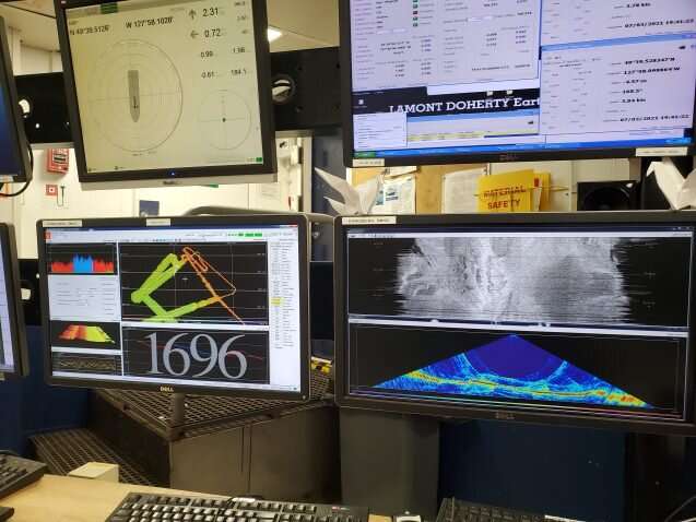
The two monitors dedicated to the multibeam allow us to control and see thedatathat is being collected. One of the screens shows the multibeam data in map view, allowing us to see the coverage and set the parameters for the instrument (Figure 1, left screen). The other screen is split into two windows that display the data in real time (Figure 1, right screen). The top window displays theseafloorreflectivity, a measure of the hardness or roughness of the seabed. The bottom window displays the data as a side swath, which essentially is a side view of the data as if we were looking at it from the behind the vessel.
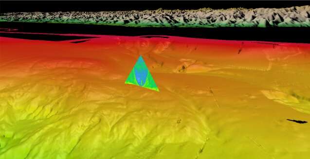
What exactly are we looking for in the multibeam data? In Figure 2, below, we can see a dynamic environment at the seafloor in southern Oregon with gullies, channels, and landslides all imaged along this small section of the margin. In addition to seafloor imaging, modern multibeam systems are capable of imaging gas bubbles within the water column. A methane seep can be seen in the new dataset which corresponds to a previously identified seep that may contain helium leaking from the Earth's mantle. New imaging techniques (Figure 3) are allowing researchers to better locate where these methane seeps are emanating from the seafloor.
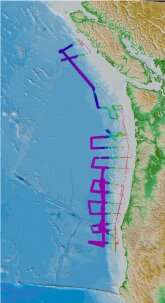
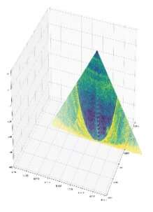
Figure 4: The coverage of new multibeam bathymetry data collected during our survey. As of June 30, the vessel has collected about 26,500 square kilometers of new data, with the rainbow-colored sections outlining the surveyed area.
Figure 1: Picture of the two screens in the main lab dedicated to the multibeam echo sounder. The left screen displays the map of coverage and windows to adjust parameters. The right screen displays the data in real time in two different formats.
Figure 2: A 3D perspective view of southern Oregon with physiographic annotations and fan view image of a methane seep. More information on methane seep exploration and seafloor mapping is available from NOAA’s Pacific Marine Environmental Laboratory
Figure 3: Annotated water-column swath of multibeam data with methane seeps identified.
Figure 4: The coverage of new multibeam bathymetry data collected during our survey. As of June 30, the vessel has collected about 26,500 square kilometers of new data, with the rainbow-colored sections outlining the surveyed area.
Figure 1: Picture of the two screens in the main lab dedicated to the multibeam echo sounder. The left screen displays the map of coverage and windows to adjust parameters. The right screen displays the data in real time in two different formats.
Careful review and interpretation of multibeam and sonar data in previous studies reveal thousands of methane seeps all scattered along the Cascadia margin. During our expedition, with the multibeam we have confirmed the location of some of these previously mapped seeps but have also identified some new ones. With careful and attentive eyes, you can spot these methane seeps in real time through the side-sweep window. However, the seeps are small in comparison to the spatial coverage of the multibeam, so they are really easy to miss and can disappear from the screen with a blink of an eye. Because of that, we mainly confirm and identify the methane seeps during the processing steps of the multibeam data. While processing the data, we are able to stack and filter to more accurately image and locate the methane seeps (Figure 3).
The multibeam data can reveal many important and interesting insights about the seafloor. Incorporating the new multibeam data collected on this cruise is one step further to having a complete high-resolution seafloor map and catalog of methane seeps along Cascadia.
Ordovician black shales of the Mount Hare Formation, Road River Group (approximately 465 million years old) rise above conglomerates of the Aberdeen Member. The dangerous rapids of Aberdeen Canyon (Nan Zhak Nadhàdlaii), created by the Peel River cutting through the resistant conglomerates, appear at bottom left. Credit: Erik Sperling
Hundreds of millions of years ago, in the middle of what would eventually become Canada's Yukon Territory, an ocean swirled with armored trilobites, clam-like brachiopods and soft, squishy creatures akin to slugs and squid
A trove of fossils and rock layers formed on that ancient ocean floor have now been unearthed by an international team of scientists along the banks of the Peel River a few hundred miles south of the Arctic's Beaufort Sea. The discovery reveals oxygen changes at the seafloor across nearly 120 million years of the early Paleozoic era, a time that fostered the most rapid development and diversification of complex, multi-cellular life in Earth's history.
"It's unheard of to have that much of Earth's history in one place," said Stanford University geological scientist Erik Sperling, lead author of a July 7 study detailing the team's findings in Science Advances. Most rock formations from the Paleozoic Era have been broken up by tectonic forces or eroded over time. "There's nowhere else in the world that I know of where you can study that long a record of Earth history, where there's basically no change in things like water depth or basin type."
Oxygen was scarce in the deep water of this and other oceans at the dawn of the Paleozoic, roughly 541 million years ago. It stayed scarce until the Devonian, roughly 405 million years ago, when, in a geological blink—no more than a few million years—oxygen likely rocketed to levels close to those in modern oceans and the diversity of life on Earth exploded. Big, predatory fish appeared. Primitive ferns and conifers marched across continents previously ruled by bacteria and algae. Dragonflies took flight. And all of this after nearly four billion years of Earth's landscapes being virtually barren.
Scientists have long debated what might have caused the dramatic shift from a low oxygen world to a more oxygenated one that could support a diverse web of animal life. But until now, it has been difficult to pin down the timing of global oxygenation or the long-term, background state of the world's oceans and atmosphere during the era that witnessed both the so-called Cambrian explosion of life and the first of Earth's "Big Five" mass extinctions, about 445 million years ago at the end of the Ordovician.
"In order to make comparisons throughout these huge swaths of our history and understand long-term trends, you need a continuous record," said Sperling, an assistant professor of geological sciences at Stanford's School of Earth, Energy & Environmental Sciences (Stanford Earth).
Context for past life
With permission from the Na Cho Nyak Dun and Tetlit Gwitch'in communities in Yukon, Sperling's team, which included researchers from Dartmouth College and the Yukon Geological Survey, spent three summers at the Peel River site. Arriving by helicopter, the research team hacked through brush with machetes beside Class VI rapids to collect hundreds of fist-sized samples of rock from more than a mile of interbedded layers of shale, chert and lime mudstone.
Back at Sperling's lab at Stanford, a small army of summer undergraduates and graduate students worked over five summers to help analyze the fossils and chemicals entombed in the rocks. "We spent a lot of time splitting open rocks and looking at graptolite fossils," Sperling said. Because graptolites evolved a vast array of recognizable body shapes relatively quickly, the pencil-like markings left by the fossils of these colony-dwelling sea creatures give geologists a way to date the rocks in which they're found.
Once the researchers had finished identifying and dating graptolite fossils, they ground the rocks in a mill, then measured iron, carbon, phosphorous and other elements in the resulting powder to assess the ocean conditions at the time and place where the layers formed. They analyzed 837 new samples from the Peel River site, as well as 106 new samples from other parts of Canada and 178 samples from around the world for comparison.
Winners and losers
The data show low oxygen levels, or anoxia, likely persisted in the world's oceans for millions of years longer than previously thought—well into the Phanerozoic, when land plants and early animals began to diversify. "The early animals were still living in a low oxygen world," Sperling said. Contrary to long-held assumptions, the scientists found Paleozoic oceans were also surprisingly free of hydrogen sulfide, a respiratory toxin often found in the anoxic regions of modern oceans.
When oxygen eventually did tick upward in marine environments, it came about just as larger, more complex plant life took off. "There's a ton of debate about how plants impacted the Earth system," Sperling said. "Our results are consistent with a hypothesis that as plants evolved and covered the Earth, they increased nutrients to the ocean, driving oxygenation." In this hypothesis, the influx of nutrients to the sea would have given a boost to primary productivity, a measure of how quickly plants and algae take carbon dioxide and sunlight, turn them into new biomass—and release oxygen in the process.
The change probably killed off graptolites. "Although more oxygen is really good for a lot of organisms, graptolites lost the low oxygen habitat that was their refuge," Sperling said. "Any environmental change is going to have winners and losers. Graptolites might have been the losers."
More information: Erik A. Sperling et al, A long-term record of early to mid-Paleozoic marine redox change, Science Advances (2021). DOI: 10.1126/sciadv.abf4382
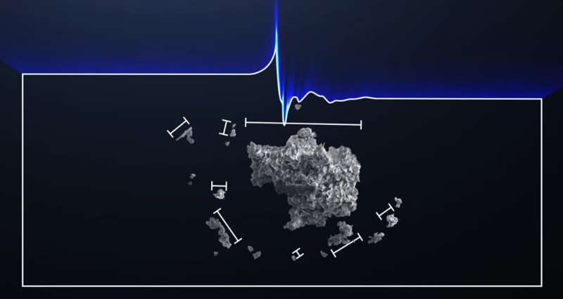
Example image of two meteorites deployed during a field test near Walker Lake, Nevada. The meteorites are marked with orange flags. Note the dark shadow of the quadrictoper drone. Credit: Robert Citron et al.
Planetary scientists estimate that each year, about 500 meteorites survive the fiery trip through Earth's atmosphere and fall to our planet's surface. Most are quite small, and less than 2% of them are ever recovered. While the majority of rocks from space may not be recoverable due to ending up in oceans or remote, inaccessible areas, other meteorite falls are just not witnessed or known about.
But new technology has upped the number known falls in recent years. Doppler radar has detected meteorite falls, as well as all-sky camera networks specifically on the lookout for meteors. Additionally, increased use of dashcams and security cameras have allowed for more serendipitous sightings and data on fireballs and potential meteorite falls.
A team of researchers is now taking advantage of additional technology advances by testing out drones and machine learning for automated searches for small meteorites. The drones are programmed to fly a grid search pattern in a projected "strewn field" for a recent meteorite fall, taking systematic pictures of the ground over a large survey area. Artificial intelligence is then used to search through the pictures to identify potential meteorites.
"Those images can be analyzed using a machine-learning classifier to identify meteorites in the field among many other features," said Robert Citron of the University of California, Davis, in a recent paper published in published in Meteoritics & Planetary Science.
Citron and his colleagues have tested their conceptual drone setup several times, mostly recently in the area of a known 2019 meteorite fall near Walker Lake, Nevada. Their proof-of-concept meteorite classifier deploys a combination of "different convolution neural networks to recognize meteorites from images taken by drones in the field," the team writes.
Video from “Meteorite Men” which describes a strewn field.
While this specific test revealed a number of false positives for rocks previously unidentified, the software was able to correctly identify test meteorites placed by the researchers on the dry lake bed in Nevada. Citron and his team are very optimistic about the potential of their system, particularly in searching for small meteorites and finding them in remote regions.
Citron told Universe Today the main challenge for setting up the system was assembling a training dataset for the machine learning classifier.
"Since a future meteorite fall could occur on any terrain," he said via email, "the system needed an object detection algorithm trained with examples of many types of meteorites on various terrain types. To create a properly trained object detection network, thousands of example images are required."
Citron and colleagues assembled images of meteorites from the internet and added in "posed" photos of meteorites from their collection on various terrains. This allowed them to properly train the machine learning model to minimize the number of ordinary rocks flagged as false detections.
A bright meteor caught by one of the Global Fireball Network’s cameras from the Rancho Mirage Observatory (Eric McLaughlin) on April 7, 2019. Credit: NASA Meteorite Tracking and Recovery Network
"Fortunately, every field test we gain more data that we can incorporate into the dataset and use to retrain the object detection network and improve the accuracy," Citron said. "So, we will continue to try and improve the detection accuracy. Currently we need a better drone with a higher resolution camera."
Studying meteorites and knowing their origins helps scientists determine the composition of some 40 asteroid families in the asteroid belt, and also aids in understanding the early evolution of the solar system. The researchers said that the remote camera network information combined with being able to find and study freshly fallen meteorites is crucial in determining what asteroid family might have produced the meteoritic debris, and if it was from a particular collision event.
"If the meteorite can be recovered, a fireball's light curve and deceleration profile also provides information about how its kinetic energy is deposited in the Earth's atmosphere," the team wrote in their paper. "That information can be used to improve predictions at what altitude asteroids of this material type fragment that are big enough to cause damaging airbursts."
However, finding meteorites from an observed fall can be very difficult, since meteorites can be scattered over a wide area.
"Smaller falls are more frequent but deliver less meteorite fragments which are therefore harder to locate," Citron said. "It takes approximately 100 man-hours to find one meteorite fragment, so if we can improve on that we can sample more of these small falls and get better insight into the orbits and therefore source regions of incoming meteors."
An example of a small, freshly-fallen meteorite in situ, found and photographed by Geoffrey Notkin. This specimen is Ash Creek, an L6 stone meteorite, which fell on February 15, 2009 in McLennan County, Texas, following a bright daytime fireball. This was the first time Doppler radar was used to locate specimens. Credit: Geoffrey Notkin
Citron said that his team's drone system is intended for smaller falls that would not attract meteorite hunters. But the team's work has attracted the admiration of one noted meteorite hunter, Geoffrey Notkin of the Discovery Channel's "Meteorite Men."
"Dr. Citron's current work in this area is fascinating, especially his bold experiments with drones in real-world situations," Notkin said via email. "The most exciting concept here is the coupling of modern drones with machine learning that can recognize the visual characteristics of meteorites in situ. Given time, this methodology could eliminate some of the tedium of searching for freshly-fallen meteorites on foot and also facilitate recoveries in areas that are difficult or dangerous for humans to search in person."
Notkin added that he has long thought that drones and uncrewed aerial vehicles (UAVs) could play a useful role in meteorite recovery, and in fact, he carried out some early experiments in 2010 and 2011, but the drones and UAVs of the time were either not advanced enough or not available to non-military personnel.
But as technology continues to improve, Citron said, and "with a larger training dataset, updated classification scheme, and improved imaging hardware, machine learning coupled to an autonomous drone survey could prove a valuable tool for increasing the number of meteorite fragments found from fresh falls."
More information: Robert I. Citron et al, Recovery of meteorites using an autonomous drone and machine learning, Meteoritics & Planetary Science (2021). DOI: 10.1111/maps.13663
ANOTHER chunk of a rare space rock has been dug up in a muddy field.
Experts believe it is part of a 4.5billion-year-old meteorite, thought to be the first to land in Britain in 30 years. 1The latest find was in the Cotswolds village of WoodmancoteCredit: SWNS
The latest fragment was unearthed about four miles from the first.
The yellow-green rock, containing the building blocks of life, is bigger than the original find. And it bears a likeness to a human face, some say. It almost certainly belongs to the same meteor which was seen burning up over Gloucestershire in February.
Fragments were later found in sheep poo on a farm in Winchcombe.
The latest find was in the Cotswolds village of Woodmancote.
Chemist Derek Robson, of Loughborough, Leics, hailed his discovery as a “very special moment”.
Scientists discover solar system ingredients inside Winchcombe meteorite
Researchers have been conducting scientific investigations on a meteorite that fell in the UK. The meteorite is known as the Winchcombe meteorite and landed in a driveway in Winchcombe, Gloucestershire, in March of this year. The meteorite is 4.5 billion years old, making it a very rare type of rock that was around at the birth of the solar system.
Researchers say the meteorite still holds its unique chemistry, so they will be able to get an idea of the ingredients present at the birth of the solar system from studying its chemical composition. Scientists have been able to date the rock with initial analysis showing it is an extremely rare type of meteorite called a carbonaceous chondrite. Meteorites of that type are rich in carbon, water, and organic matter.
Investigators have been specifically probing the organic matter present in the meteorite. Researcher Professor Mark Sephton says the organic molecules in the rock are older than the Earth itself. He notes that similar molecules would have rained down on the early Earth before life emerged and could represent the first chemical steps towards life in the early solar system.
The organic molecules in the meteorite could be leftover ingredients from the early recipe for life on Earth. A small part of the organic content of the meteorite is present as free molecules that can be extracted using solvents. However, the larger part is present as a large organic network requiring heat and hydrogen to break into small fragments that can be investigated.
Simply finding the meteorite was a challenge. A team of researchers was able to pinpoint its location using images and video footage. Among the data used to locate the meteorite were images captured by the UK Fireball Network. European scientists say that about 20 meteorites land on earth each year over the UK, most no bigger than the size of a sugar cube, making them difficult to find.
Astronomers map interstellar dust grains in Milky Way
Between the stars in our Milky Way, vast amounts of tiny dust grains are floating aimlessly around. They form the building blocks of new stars and planets. But we still don't know what elements exactly are available to form planets like Earth. A research team at SRON led by Elisa Costantini has now matched observations from X-ray telescopes with data from synchrotron facilities to create a map of interstellar grains in the Milky Way.
If our galaxy shrank to the point where stars were the size of marbles, there would still be about a thousand kilometers between each of them. So it is safe to say that galaxies consist mostly of empty space. Still, this space is not as empty as you might think. It is filled with the so-called interstellar medium. The larger part of this is made up of tenuous gas, but around one percent is in the form of tiny grains of about 0.1 micron—one thousandth the width of a human hair.
These grains are formed during the life cycle of stars. A star, and the planets around it, are formed by a collapsing cloud of gas and dust. When the star evolves toward the end of its life, it expels a good fraction of its mass in the surrounding medium, creating new material for dust formation. If the star ends its life with a supernova explosion, it will further enrich the environment with even more gas and dust. This in turn will eventually constitute new building blocks for stars and planets. As Carl Sagan said, "We are made of stardust." But what elements exactly are available in the interstellar medium to form planets like Earth is still unknown.
The interstellar dust research group at SRON Netherlands Institute for Space Research, led by Elisa Costantini, has now studied the interstellar grains in our Milky Way using X-ray radiation. They were able, for the first time, to explore the properties of the dust in central regions of the galaxy, and found that those grains are consistently made of a glassy silicate: Olivine, which is a compound of magnesium, iron, silicon and oxygen. The interaction with stellar radiation and cosmic rays melted these grains to form little glassy irregular spheres. When moving further out to more diffuse regions away from the galactic center, the team found clues for the presence of a larger variety in dust composition. This may give rise to diversified planetary systems. It might even be that our planetary system is the exception rather than the norm.
Costantini comments, "Our solar system was formed in the outer regions of the galaxy and is the result of a complex sequence of events, including nearby supernova explosions. It remains an open question what is the right environment to form planetary systems and which of these events are vital to form a planet where life can flourish."
To get to their results, Costantini and her group matched observations from X-ray telescopes and synchrotron facilities. They used the latter to characterize the features that interstellar dust analogues like silicates, oxides and sulfates produce in X-rays. Then they compared these to the astronomical data to find the best matches. Observing several lines of sight allowed them to explore different environments of the Milky Way.
The research team used using the synchrotron facilities Soleil-LUCIA beamline, the Dubble-ESRF beamline and the Titan electron microscope at the University of Cadiz. On the astronomical side, they used the X-ray observatories XMM-Newton (ESA) and Chandra (NASA).
A team of the University of Barcelona has analyzed for the first time what the dry and hot periods could be like in the area of the Pyrenees depending on different greenhouse emission scenarios. The results, published in the journal Natural Hazards and Earth System Sciences, show that under an intermediate scenario, where these emissions that accelerate the climate change could be limited, there would not be a rise in long-lasting dry episodes, but temperatures would rise during these periods. On the other hand, if those emissions were not reduced during the 21st century, the summer no-rain periods would last an average of five more and, in addition, they would go with a rise of temperatures 6ºC over the current ones in the Pyrenees. According to the authors, these results would involve "a potential increase in environmental risks such as wildfires, crop yield losses, negative effects on biodiversity and water resources, etc.".
The study counts on the participation of the researcher Marc Lemus-Canovas, from the Climatology Groupof the UB, and the lecturer Joan Albert López-Bustins, from the Department of Geography. Both are members of the Water Research Institute of the UB.
Two variables that increase environmental risks
The study analyzed, on the one hand, whether the length of consecutive days without rain has increased or will increase in the future, and on the other, whether the highest temperatures during the long-lasting dry periods will be higher than the current ones. This is the first time these variables are studied together in the area of the Pyrenees, in an approximation that enables avoiding an underestimation of the risk these climate conditions bring to the area. "Plants are under a hydric stress due to a combination of a long-lasting dry periods and a high temperature, and the stress is higher than if we analyze one of the compounds. The concurrence of long-lasting dry periods and extremely hot temperatures can bring environmental risks such as wildfires, crop yield losses, and in general, serious problems regarding the biodiversity of this area, which would not be detected by considering only one of the variables," says Marc Lemus.
The study used climate data from several parts of the Pyrenees (Catalan Pyrenees, Aragon Pyrenees, etc.) from 1981 to 2015, in the information obtained from the work carried out at the Pyrenees Climate Change Observatory, thanks to the CLIMPY project, which enabled recovering a great part of climate series. "These data show that to date, the risk of the simultaneous concurrence of long-lasting droughts and extreme temperatures has been increased by the raise of one of these cmpounds: temperature. This has taken place similarly in spring and summer and over the general area of the Pyrenees," notes the researcher.
More and more extreme temperatures
In order to estimate the evolution of these two variables during the rest of the 21st century, the researchers considered two out of the future scenarios of greenhouse emissions established by the UN Representative Concentration Pathways group. "Under an intermediate scenario of emissions (RCP4.5), assuming that by the middle of the century the emissions will start a process of stabilization and that by 2100 there will not be a growing trend of gas emissions, the pattern will continue to be the same: temperatures will be more extreme when these dry spells occur, but the length of these dry periods will not increase," describes the researcher.
On the other hand, this situation would substantially change under a scenario of high emissions (RCP8.5), where the volume of emissions would continue to rise during the whole century. Under these conditions, the authors detected that there would be, in spring, an increase in the length of dry periods, mainly in the eastern side of the Pyrenees, and a strong increase in thermal extremes during these dry spells. "Regarding summer, the length of days without rain will increase notably in the northern side of the Pyrenees (the wettest area of this territory) and there will also be a rise of extreme temperatures. The less exposed area to this factor in both elements would be the western area, with a higher Atlantic influence," notes Marc Lemus. According to the researchers, these results highlight the importance of stopping the increasing trend of greenhouse emissions. "We saw it is not ideal in an intermediate scenario because the thermal increase is notable. However, a dramatic increase in the length of dry periods and in extreme temperatures at the same time could lead to a catastrophic scenario, due to the involvements it could have in a fragile area where the 59% of the surface is covered by forests," they warn.
In this sense, the research states that this study should provide "more arguments to the provision of public resources for the actors that work on forest and ecological management of the Pyrenees, in order to adapt it for the future. And mainly, to promote a mitigation policy on climate change which is our pending subject," he concludes.
Recently, the Climatology Group of the UB has received a favorable resolution from the Spanish Ministry on Science and Innovation for the grant of a research project titled Eventos compuestos secos y cálidos en la España peninsular, which will enable the team to receive resources to continue working on this research line for the next three years.
More information: Marc Lemus-Canovas et al, Assessing internal changes in the future structure of dry–hot compound events: the case of the Pyrenees, Natural Hazards and Earth System Sciences (2021). DOI: 10.5194/nhess-21-1721-2021
Glaciers are iconic benchmarks of climate change, and their meltwater represents an important water resource downstream, particularly in spring and summer.
A study by researchers from Utrecht University and Chinese Academy of Sciences shows that the melting of seasonal snowpacks in Asia provides an even larger contribution to river streamflow. The water supply from snowmelt has changed considerably over the last 40 years and it will further diminish in the future under continued climate change, with potentially strong impacts on downstream water availability.
The study was published in Nature Climate Change on June 24.
The researchers developed a computer model that simulates snow and compared it with their previous estimates of glacier change. "We see that for all river basins that originate in the high mountains of Asia, the total amount of snowmelt is much larger than glacier melt, generally around three to five times as much," said lead author Philip Kraaijenbrink. "Changes to the region's snowpacks due to climate change can therefore have much stronger impacts on the water balance than retreat of its glaciers."
The scientists predicted that there will be considerable losses in the amount of snowmelt in Asia's rivers, but the degree of future climate change plays a key role. "If we are able to limit temperature rise by the end of the century to 1.5 degrees when compared to pre-industrial levels, as agreed upon in the 2015 Paris agreement, we will see region-wide reductions in snowmelt of only 6%," said co-author Walter Immerzeel, Professor in Mountain Hydrology at Utrecht University. "However, in more realistic scenarios, snowmelt will be reduced by 22% and for specific regions by even more than 50%. Such reductions in meltwater input into the rivers during spring can strongly affect people downstream that depend on that water for irrigation and hydropower."
How these results will impact local water availability remains a research challenge for the future according to the researchers. "This study helps us gain a fuller picture of the water cycle changes at the Third Pole," said co-author Prof. Yao Tandong, co-chair of Third Pole Environment (TPE), an international science program that enabled long-term international collaboration on this topic with support from the science project of Pan-TPE.
"Snow and glacier melt are only a part of the total water cycle. Climate change acts on many fronts and controls the changing water supply from the mountains, but there are also socioeconomic developments to consider that affect water demands," added Philip Kraaijenbrink. "Our future efforts are on quantifying all processes that impact the mountain water balance to ultimately fully understand the changing system and its impacts on society."
More information: Philip D. A. Kraaijenbrink et al, Climate change decisive for Asia's snow meltwater supply, Nature Climate Change (2021). DOI: 10.1038/s41558-021-01074-x
A new study conducted before COVID-19 busted open the leaky pipeline for women in leadership underscores the bias that men are naturally presumed to have leadership potential and women are not and highlights the increased efforts needed by organizations to address the incorrect stereotype post-pandemic.
The research published in the journalFrontiers in Psychologyhighlights the continuing bias inleadershipassessments of women, explores the contradictions between the perception and the reality of women's leadership, and shows why the slow rate of career advancement for women will likely continue at a snail's pace.
"The impact of the COVID-19 pandemic on women's career progression will likely be felt for years to come as many women stepped away from the workforce," said Dr. Margaret Hopkins, professor of management in The University of Toledo's John B. and Lillian E. Neff College of Business and Innovation and lead author of the study. "This can only exacerbate the slow progress of women moving more fully into senior leadership roles—something that organizations and society must be fully attentive to correcting."
The contemporary view of effective leadership places a strong emphasis on social skills, flexibility and engaging others, behaviors typically associated with women.
But when women exhibit gender role behaviors such as teamwork and empathy, they also pay a price in their leadership performance assessments.
Based on data collected from a sample of 91 senior leaders in one U.S. financial services organization over three years, women were penalized in performance evaluations when they displayed those leadership characteristics.
On the other hand, women also were viewed negatively when exhibiting stereotypical masculine behaviors such as a competitive drive to achieve, task orientation and directing others. Men were positively evaluated for their leadership potential when exhibiting those same behaviors.
"Entrenched archetypes that define leadership as a masculine enterprise remain in spite of data that relates more stereotypical feminine behaviors to effective leadership," said Hopkins, an expert on women in leadership, executive coaching and emotional intelligence. "Our study found no evidence of acknowledging this more contemporary view of leadership when organizations actually assess women's performance and potential for leadership."
The researchers discovered that whether women demonstrated people-oriented, relational skills or whether they exhibited achievement-oriented behaviors, there was a negative effect on their leadership performance assessments and leadership potential appraisals. However, this was not the case for the male leaders in the study.
In order to change the dynamic, Hopkins said there are best-practice strategies that both women and organizations can take.
"My co-authors and I do not support the notion that the onus is on the women to change," Hopkins said. "Rather, organizational structures and systems must change to provide leadership opportunities for both women and men in equal measure."
She said organizational decision-makers can investigate organizational policies and practices to determine how they might be contributing to impediments for women in leadership roles.
Not only should leadership assessment instruments be examined for possible bias, but also the methods by which individuals conduct assessments of women leaders should be reviewed for inherent bias.
"Hiring procedures, training and development opportunities, benefits packages, leave policies, and performance, salary and promotional evaluations can all play a part in contributing to gender stereotypes," Hopkins said. "Organizational systems that rely on a limited framework for essential leadership behaviors will restrict their ability to recruit and develop outstanding leaders."
To help mitigate these inaccurate perceptions and biases of their leadership performance and potential, Hopkins suggests that women find both female and male allies and sponsors, create strategic networks, seek high-profile assignments to highlight their skills and abilities, and develop and communicate their individual definitions of career success.
The financial services organization at the focus of this study is one of the Top 100 U.S. Best Banks named by Forbes magazine. The sample of senior leaders included 26 women and 65 men, representative of the gender composition of the senior leadership team.
The researchers said a comparison of males and females in one organization ensured that any observed gender differences were not due to factors such as differences in industries or management hierarchies across organizations.
Researchers from UToledo, Bowling Green State University, Case Western Reserve University and San Diego Gas and Electric collaborated on the study.
More information: Margaret M. Hopkins et al, Buried Treasure: Contradictions in the Perception and Reality of Women's Leadership, Frontiers in Psychology (2021). DOI: 10.3389/fpsyg.2021.684705
Larger fishing trawlers are seen in Point Judith, Rhode Island. Communities of vessels have varying responses to shift in species' distribution, based in part on the relative size of vessels. Credit: Courtesy of Eva Papaioannou
What happens when climate change affects the abundance and distribution of fish? Fishers and fishing communities in the Northeast United States have adapted to those changes in three specific ways, according to new research published in Frontiers in Marine Science.
Becca Selden, Wellesley College assistant professor of biological sciences, and a team of colleagues examined how fishing communities have responded to documented shifts in the location of fluke and of red and silver hake. The team found that fishers made three distinct changes to their approaches: following the fish to a new location; fishing for a different kind of fish; and bringing their catch to shore at another port of landing.
Selden began this research as a postdoctoral scholar at Rutgers University in New Jersey with Eva Papaioannou, now a scientist at GEOMAR. They combined quantitative data on fish availability from surveys conducted by the National Marine Fisheries Service at the Northeast Fisheries Science Center and a unique geographic information system database from fishing trip records developed for this project. The researchers then interviewed fishers in 10 ports from North Carolina to Maine.
They explored three dominant strategies, and found that fishers throughout the Northeast were more likely to shift their target species. In interviews, the researchers learned that targeting a mix of species is a critical option for adaptation. Doing so can be complicated, however, because in many cases regulations and markets (or the lack of a market) constrain fishers' ability to take advantage of a changing mix of species in fishing grounds. For example, in Point Pleasant, N.J., fishers can't capitalize on an increase in dogfish in the region because of strict conservation measures that have been in place since 1988, when the species was declared over-fished, and the resulting absence of a market for those fish.
"Most communities tend to fish where they have fished for generations, and therefore, for any fishery management plan to be more climate-ready in the future, it needs to take that into account," Selden said. "They're less likely to move where they fish, more likely to switch what they fish, but only if they can, and regulations play a big role in that being successful."
The researchers also learned about a previously undescribed strategy in which fishers change where they bring the fish ashore to sell. This is particularly common for vessels coming from northern fishing communities that sell fluke in Beaufort, N.C. "Had we not combined the quantitative data with the in-depth interviews with community members, we would have totally missed the phenomenon we saw come to light in Beaufort," Papaioannou said. "It made for such a powerful way of analyzing the data, so that we were really using it to influence the questions we would ask in each interview, and the interviews would drive what we would examine in the quantitative data. I think that approach really made for a much more complete look at the impact of changes in species distribution and fishers' adaptations."
Of the fishing communities they studied, only the one in Beaufort used the tactic of following fish to new grounds. Unlike communities in the north, fishers in Beaufort have targeted fluke heavily in the past, and because the port is on the southern edge of the range for this species they are more vulnerable as the species shifts north. "Beaufort fishers have gone to tremendous lengths to keep fishing fluke," Selden said, "and following fish to new grounds brings its own constraints and concerns." These include the cost of increased fuel use, safety issues due to vessel size, and the local environmental knowledge needed to fish successfully in new locations.
All of these responses are intertwined, Selden said, so as we learn more about the effects of climate change on the future of fishing, understanding, predicting, and planning for any one of them will require examining all three together.
The researchers focused on the Northeast because it has been a hotspot of recent ocean warming, especially in the Gulf of Maine, and in some ways it is a harbinger of what other areas might be experiencing soon, Selden said. Along the East Coast, she said, "you have species that have these state-by-state regulations, you're passing through different jurisdictions and three different fisheries management councils, and species are crossing boundaries all over the place. This all has an impact on fishers, their behavior, and their communities."
Selden plans to continue this work on the West Coast—where there are only three states and one fishery management council—to compare how stable their fishing grounds are and how much fishers are switching species versus shifting where they fish.
"Fisheries are really on the frontline of climate impacts," Selden said. "It's really a bipartisan issue, and there are stakeholders across party lines. That was my motivation to focus on how communities are adapting, how they've adapted to past change. We need to be able to understand how they might adapt to future change and potentially how we would need to change management to facilitate some of the adaptations that they are already demonstrating."
The team is building a website that fishers and communities can use to see some of these patterns and learn more about what their counterparts elsewhere are doing about them. Community leaders and fishery management officials could also use the information to promote a broader understanding of the issues and potentially prioritize fishery development projects or plan for where a species will go next.
More information: Eva A. Papaioannou et al, Not All Those Who Wander Are Lost – Responses of Fishers' Communities to Shifts in the Distribution and Abundance of Fish, Frontiers in Marine Science (2021). DOI: 10.3389/fmars.2021.669094


 rise above conglomerates of the Aberdeen Member. The dangerous rapids of Aberdeen Canyon (Nan Zhak Nadhàdlaii), created by the Peel River cutting through the resistant conglomerates, appear at bottom left. Credit: Erik Sperling")

 on April 7, 2019. Credit: NASA Meteorite Tracking and Recovery Network")