VULCANOLOGY
Underwater Volcano Fukutoku-Okanoba Explodes

August 13, 2021
The eruption of an underwater volcano near South Iwo Jima sent a plume soaring into flight paths and created an expansive raft of floating rock.
Over the past decade, the Japan Coast Guard has occasionally spotted patches of milky blue water about 5 kilometers (3 miles) north of South Iwo Jima island. The discolored water has been a subtle reminder that the summit of an active volcano—Fukutoku-Okanoba—lurks about 25 meters (80 feet) below the water surface.
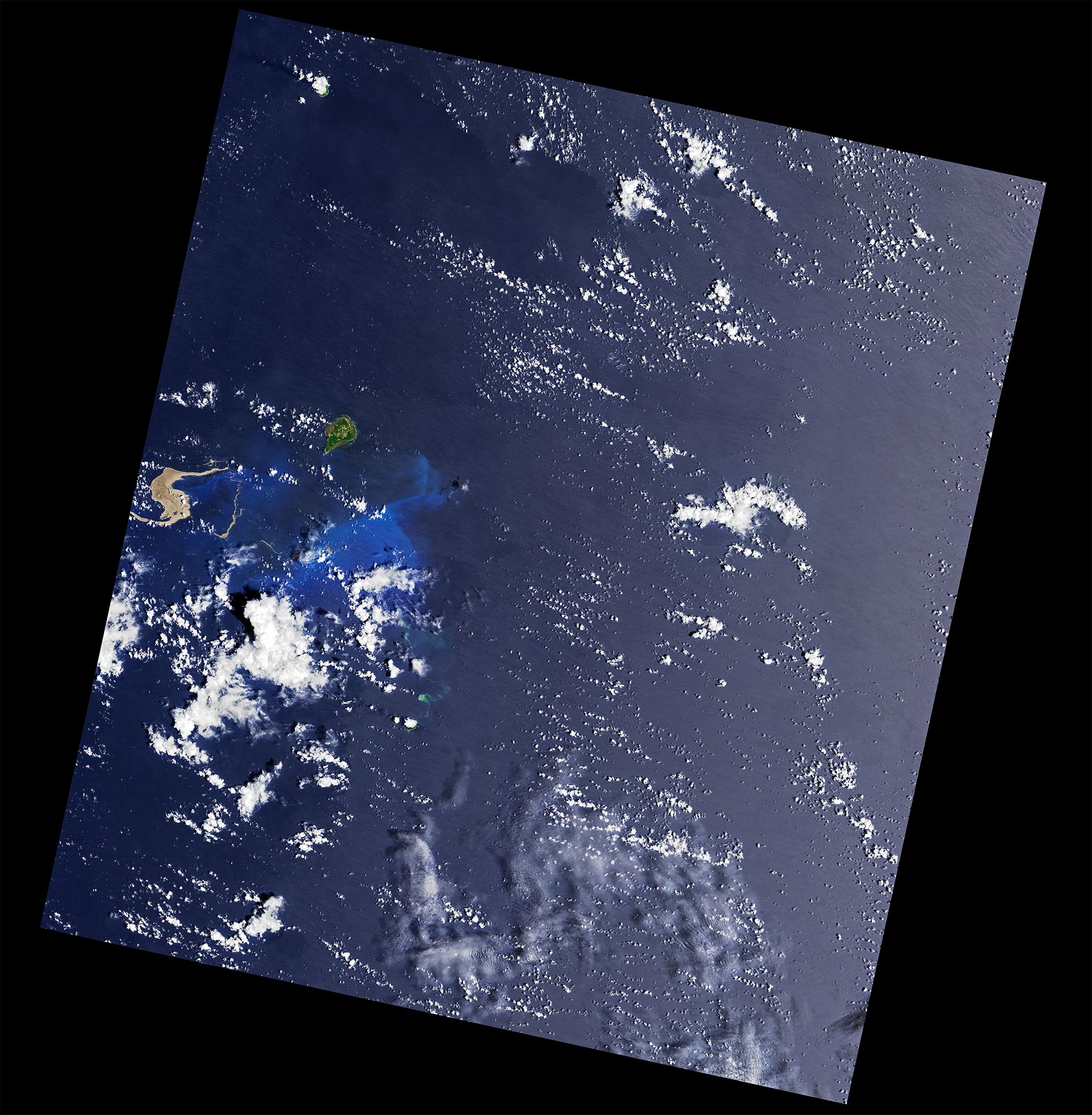
On August 13, 2021, there was much more than just discolored water. A photograph taken by a Coast Guard aircraft flying near the volcano showed a towering plume of gas rising several kilometers into the air—a sure sign that explosive “Surtseyan” eruptions were happening.
Satellite observations and follow-up flights filled in more details. The Japanese geostationary satellite Himawari 8 was among the first satellites to observe the eruption, showing its beginning stages at about 21:00 UTC (6 a.m. local time) on August 12, 2021. When NASA’s Moderate Resolution Imaging Spectroradiometer (MODIS) sensor on the Terra satellite acquired its first image of the event on August 13, it showed a bright plume—likely steam and volcanic gases—streaming from the vent and stretching hundreds of kilometers to the west.
The longevity and vigor of the plume surprised some scientists. “What was remarkable about this eruption is that it went straight from being a submarine event to an eruption cloud reaching the lower boundary of the stratosphere,” explained Andrew Tupper, a meteorologist with Natural Hazards Consulting and a specialist in hazards to aviation. “That is not very common for this type of volcano. We normally see lower-level plumes from submarine eruptions.”
August 17, 2021
On August 14, NASA’s Cloud-Aerosol Lidar with Orthogonal Polarization (CALIOP) sensor detected the plume reaching as high as 16 kilometers (11 miles) above the surface, according to Ghassan Taha, an atmospheric scientist based at NASA’s Goddard Space Flight Center.
The amount of water in the vicinity of the vent plays a key role in determining the explosivity of submarine eruptions. “Explosivity is linked to the proportions of water and the erupting ‘stuff’—volcanic gases, ash, and lava,” explained Erik Klemetti, a volcanologist at Denison University. “Volcanoes with lots of water relative to erupting stuff are less explosive. Volcanoes with less water relative to the erupting stuff are more explosive. If this eruption was in shallow water, say just a few meters, then the presence of that water would have enhanced the explosivity.”

Scientists and aviation groups track volcanic eruptions closely because ash can pose a risk to aircraft. Volcanic ash is made up of tiny, jagged rock and glass particles that can damage jet engines and even cause them to fail. Ash poses a particular threat when it rises above the normal cruising altitude of jets—about 10 kilometers (6 miles). “The problem with fresh eruptions is that it can be very difficult to work out if it is safe for pilots to fly underneath due to the risk of falling ash,” said Tupper. In this case, the Tokyo Volcanic Ash Advisory Center at the Japan Meteorological Agency issued an ash advisory to pilots within a few hours of the eruption. Multiple Philippine Airlines flights to Japan were canceled as a result.
Fukutok-Okanoba left its mark on the sea surface as well. In the Landsat 8 image above, the sides of a new parentheses-shaped island outline the volcano’s caldera. It is unclear how long these features will last; the volcano has created ephemeral ash and pumice islands in the past that eroded away not long after their formation. According to Smithsonian’s Global Volcanism Program, the volcano’s most recent island formed in 1986.
August 17, 2021
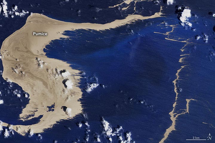
Landsat 8 imagery also show several floating rafts of pumice drifting northwest of the eruption site. The satellite’s Operational Land Imager (OLI) captured a remarkable image (above) of expansive gray pumice rafts on August 17, 2021, a few days after the eruption began.
Pumice is one of the only types of rock that can float due to a combination of surface tension and the many air-filled holes and cavities found within the rock. Rafts of the rock can drift in the ocean for months or even years. As they drift, the volcanic rocks often pick up various forms of life, ranging from bryozoans to barnacles to crabs.

But what is home for marine life can be hazardous to ships. In addition to scratching hulls and propellers, floating chunks of pumice can clog cooling systems and engines. “Aviation and marine warning systems for remote submarine volcanoes are still very much developing,” said Tupper. “Combining cutting-edge satellite data with surface observations gives us the best possible chance to respond in time.”
NASA Earth Observatory images by Joshua Stevens, using Landsat data from the U.S. Geological Survey and MODIS data from NASA EOSDIS LANCE and GIBS/Worldview
Weathering is key to locking up some of the atmosphere's natural carbon dioxide.
BY ANGELY MERCADO | UPDATED AUG 27, 2021
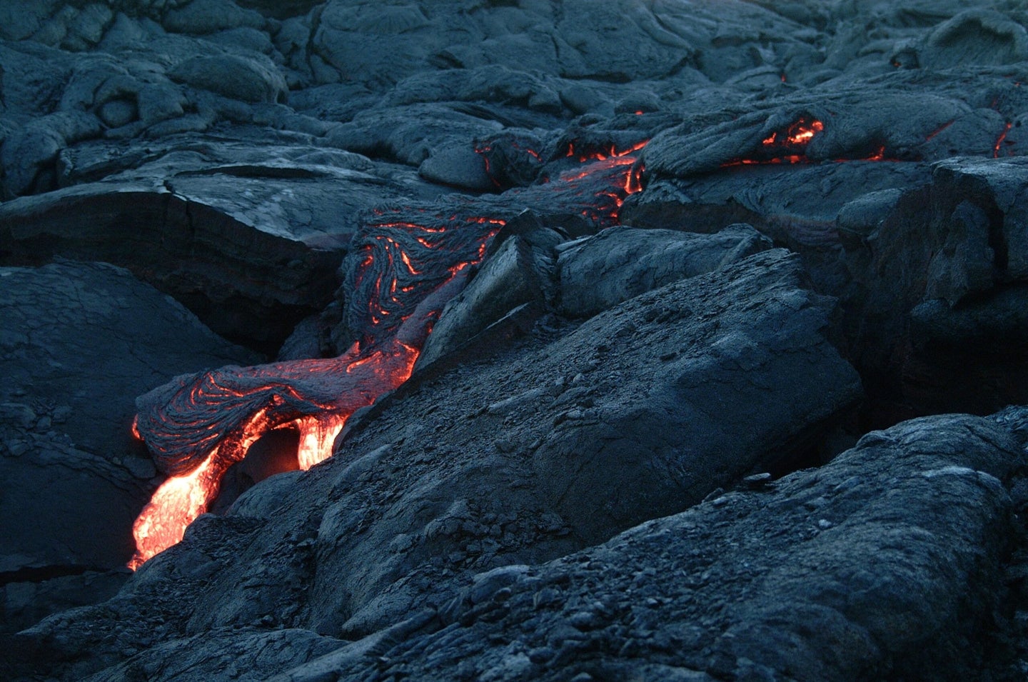
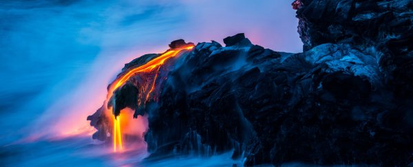
Volcanoes emit a lot of carbon while erupting—but are able to balance themselves out. Brent Keane from Pexels
Along with the belt of volcanoes that dot the ocean floor across the globe, there are about 1,500 potentially active volcanoes around the world—many of which are in the Pacific “ring of fire”, a ring of active volcanoes and earthquakes along the Pacific Ocean. Their presence has sparked legends and origin stories, such as the true story of the volcanic eruption of Nabukelevu.
It turns out that volcanoes provide important climate mechanisms as well. Researchers at the University of Southampton found that volcanoes are responsible for both emitting and removing atmospheric carbon dioxide (CO2), which has helped stabilize the Earth’s surface temperature over millions of years. The findings were recently published in Nature Geoscience.
The scientists worked alongside colleagues at the University of Ottawa, University of Leeds, the Australian National University (ANU), and the University of Sydney. They investigated the combined impact of processes in the solid Earth, oceans, and atmosphere over the past 400 million years— aka how different processes including how the ocean helps capture some of the atmosphere’s CO2 is connected to other naturally occurring processes.
[Related: Did the dip in carbon emissions during the pandemic really help the atmosphere?]
“It’s a balancing act. On one hand, these volcanoes pumped out large amounts of CO2 that increased atmospheric CO2 levels. On the other hand, these same volcanoes helped remove that carbon via rapid weathering reactions,” says coauthor Martin Palmer, a professor of geochemistry at the University of Southampton via a press release.
The researchers worked together to create an “Earth network” using machine-learning algorithms and plate tectonic reconstructions. This network helped them interpret how different interactions in the Earth’s systems, including systems of volcanoes, have changed over time and have affected the CO2 in the planet’s atmosphere.
One process they extensively researched is chemical weathering releases calcium, magnesium, potassium, or sodium ions. These elements form minerals that lock up CO2 from the atmosphere, regulating global climate over geological time. Volcanic rock is fragmented and chemically reactive and can rapidly weather down and end up in the oceans to help trap CO2.
These new findings cast some doubt over the long-held idea that the ocean is the largest driving factor for weathering and natural carbon capture. Lead author Tom Gernon, an associate professor of earth science at the University of Southampton, calls volcanoes a “geological thermostat” that helps regulate the earth’s CO2 levels. When asked if volcanoes can be used to mitigate the current climate crisis, Gernon points out that CO2 emissions are at record high levels.
“Conventionally, it’s assumed that global weathering is driven by a kind of an interplay between … the continental interiors and the oceans—the seafloor. That’s often assumed to be the main drivers [of weathering] … we show that actually, that may not be true,” says Gernon.
This means volcanoes could be important in the weathering process as well. But are volcanoes the answer to our record-high carbon emissions and rapidly changing climate? It’s trickier than it seems, Gernon says.
[Related: Why can’t we burn our trash in volcanoes?]
“The volcanoes certainly aren’t a solution, in themselves,” Gernon says. “If we can kind of engineer that system, and try to maybe deploy certain compositions of rocks as an enhanced weathering tool to draw down CO2 [that] may play some role … [but volcanic rock] is not a silver bullet solution to the climate crisis. It has to be just one part of many solutions needed for different mitigation measures that the IPCC has advised.”
He hopes that the machine learning tool and the data collected can lead to potential solutions that involve volcanic rocks in the future. Using broken-down rocks can in fact pull some CO2 from the atmosphere, according to a 2020 study showed that spreading dust rock on farmland can “remove about half of the amount of that greenhouse gas currently produced by Europe,” according to the Washington Post. This works because the carbonate materials in the rock dust will dissolve when it comes in contact with water. CO2 is drawn in to form bicarbonate ions that then become carbon-storing carbonate minerals after they’re washed away into the ocean.
“I have colleagues who are working on enhanced weathering mineral carbonation—using grinding up minerals doing experiments on what compositions and grain size distributions work best [for weathering],” he says. “Those experiments need to be done to demonstrate the applicability or the effectiveness of this approach.”
Rinjani volcano lets off a puff of ash and steam in July 2013. The still-active volcano is part of what used to be Samalas volcano, which exploded in 1257 A.D. Credit: Ulet Ifansasti/Getty Images
Aug 27, 2021, 9:00 AM EDT
But... what volcano erupted?
Weirdly, until recently no one knew just which volcano on Earth had exploded. This had geologists scratching their heads until just a few years ago, when multiple lines of evidence pointed towards the literal smoking gun: The Samalas volcano on the island of Lombok in Indonesia.
The strongest evidence of such a catastrophic eruption came from ice cores, both from the Arctic and Antarctic. Every year, a fresh layer of ice is laid down in these areas, trapping gases and particulates in the atmosphere. They can be dated extremely accurately, making them crucial in determining ages of global climactic events.
Volcanic sulfate deposits spike hard in ice deposits dated to 1257/1258 A.D., indicating an eruption far larger than both Krakatau (in 1883) and Tambura (1815), eight times and twice as powerful, respectively.
The new work looking at the eruption examined evidence from radiocarbon dating, tree rings, the geochemistry of volcanic deposits, and even an ancient historical record called the Babad Lombok, written in Old Javanese on palm leaves, that documents the explosion.
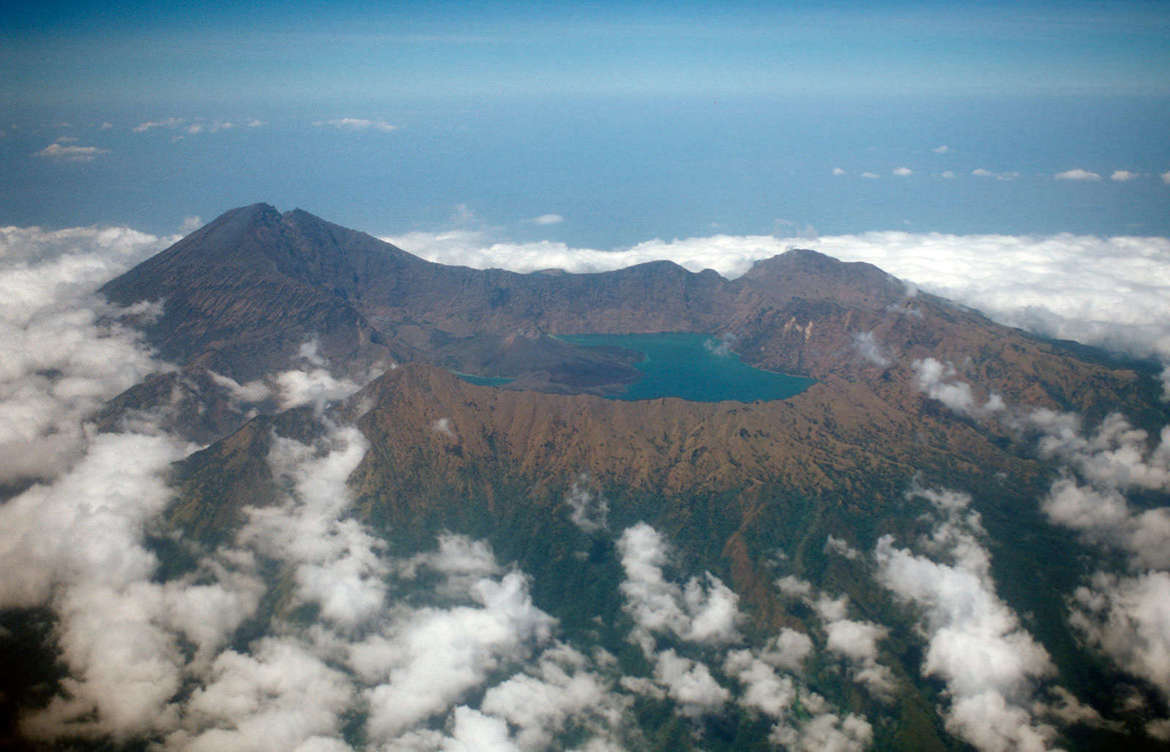
Aerial view of Rinjani volcano on Lombok Island in Indonesia, the site of a catastrophic eruption in 1257 A.D. Credit: Reinhard Dirscherl/ullstein bild via Getty Images
The Babad Lombok talks about an eruption from a volcano called Samalas, now part of a volcanic complex that includes Mount Rinjani (which towers over 3,700 meters above sea level) and a huge caldera that is partially filled with water, forming a crater lake called Segara Anak. This complex is still active, with eruptions still occurring now. A developing cone, called Gunung Barujari, has been growing for some time, including via eruptive events in the mid-'90s.
The Babad Lombok puts the eruption in the mid to late 13th century, consistent with the ice cores. In 1258 the northern hemisphere experienced an unseasonably cold summer, with heavy rains and flooding that resulted in widespread crop failures in Europe. This too is consistent with a huge eruption; dark particles can rise in to the stratosphere and block a fraction of sunlight, dropping temperatures.
Compellingly, tephra — pieces of rock and ash blown out by volcanic eruptions — dated to around that time have been found in both northern and southern hemispheres, implying the volcano itself was near the equator.
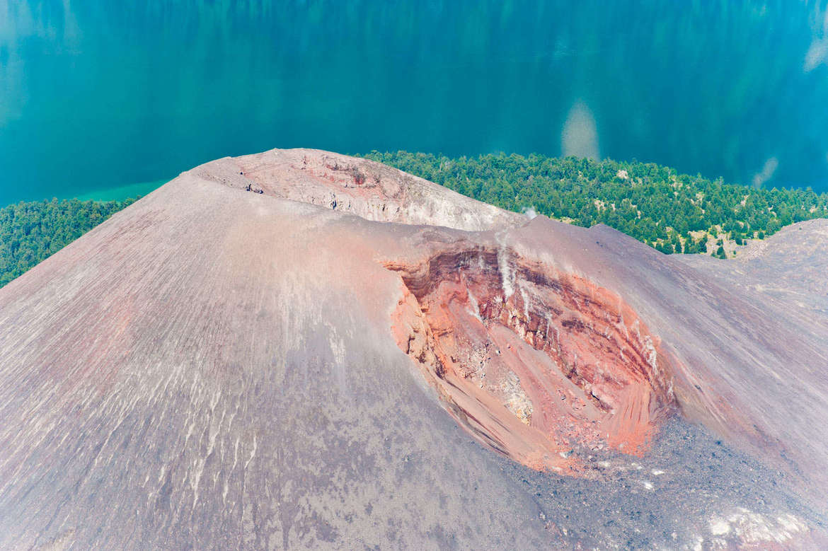
The Gunung Barujari volcano is part of Rinjani volcano, and a relatively new cinder cone that grew rapidly in the 1990s.
Assuming the Babad Lombok did describe this eruption, geologists looked to the Samalas caldera and surrounding areas for evidence. Burnt tree trunks and branches were dated to 1257 A.D. using carbon-14 (a radioactive form of carbon that can quite accurately determine the ages of events that affect living matter), and no young trees were found after that date, indicating catastrophic conditions at the time.
Field work in the Samalas caldera and surrounding islands shows tephra deposits all over the region. Glass shards in the deposits match the chemistry of similar ones found in the ice cores dated to the event as well. Mapping the tephra deposits in the area, the scientists found it totaled up to 7.5 cubic kilometers — as much as 7 billion tons of fallout.
But the total volume erupted was much, much larger: Models of the pre-eruption volcano indicate it rose to a height of about 4,200 meters above sea level (about 13,800 feet — roughly the size of the largest mountains in Colorado’s Rocky Mountain National Park). During the eruption the peak collapsed. Looking at all the components of the event, the scientists find that at least 40 cubic kilometers of material were blown out, and the ash plume would have risen a staggering 43 kilometers into the sky, possibly as high as 50 km. It would have been visible from hundreds of kilometers away.
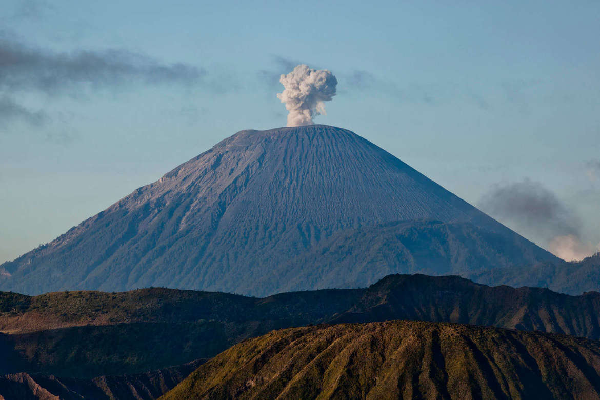
Rinjani volcano lets off a puff of ash and steam in July 2013. The still-active volcano is part of what used to be Samalas volcano, which exploded in 1257 A.D. Credit: Ulet Ifansasti/Getty Images
Looking at the event in total, it would have rated about a 7.0 on the Volcanic Explosivity Index, a logarithmic scale where, for example, the 1980 Mount St. Helens eruption rates a 5 and the last Yellowstone caldera supereruption 600,000 years ago was an 8. The Samalas eruption was therefore among the largest in the past 12,000 years.
The eruption was apocalyptic, and must have been terrifying to the local population (the capital of the Lombok kingdom, a city called Pamatan, was wiped out, and remains undiscovered; if ever found it may be resemble Pompeii). There were steam explosions as hot magma reacted to sea water (called phreatic eruptions), followed by a magmatic explosion that blasted pumice and rocks out to great distances (several hundred kilometers). After that there were pyroclastic flows; hot ash and gases that can move at hundreds of kilometers per hour and be scorching hot. Deposits on Lombok Island reached depths of 35 meters — the height of an eight-story building.
Mind you, all of the evidence for this until a few years ago was indirect and scattered. This work ties it all together, including the newer climate change effects in the northern hemisphere.
Speaking of which, and given the recent release of the IPCC Sixth Assessment Report on climate change, you might hear some folks saying that volcano eruptions account for much of the carbon dioxide released into the atmosphere; I saw a tweet making this claim myself. This is not only wrong, but utterly wrong; human activities emit more than one hundred times the carbon dioxide of all the volcanoes all over the world. An eruption by something like Samalas would actually cool us down due to dark particulates that blanket the atmosphere, but only a little, only for a little while, and at great, great cost.
Immense events like the Samalas eruption can change the course of human history, but on the scale of the planet can prove difficult to pin down. Human activity, on the other hand, has the ability to change the planet as well, and that can be found everywhere. I was horrified to read about the power of this ancient eruption, but was sobered to remember that we ourselves are doing far worse, and we do so continuously.
Unlike the planet, we have a choice.
(SinghaphanAllB/Moment/Getty Images)
DAVID NIELD
28 AUGUST 2021
Travel back in time 56 million years, and you'd arrive during a period of heightened volcanic activity on Earth. The activity triggered significant shifts in the planet's climate, effectively turning some parts of the far north into a tropical paradise.
The outpouring of carbon dioxide is one cause for this warming, but it seems there's more to the story. According to a new study, the volcanism plugged up the seaway between the Arctic and Atlantic, changing how the oceans' waters mixed.
While the Paleocene-Eocene Thermal Maximum (PETM) is a well-known event in the geological history of Earth, the remote area of northeast Greenland studied here hasn't been the subject of much geological research – even though it lies at a crucial point for volcanic activity and the flow of water between the Arctic and the Atlantic.
Through a combination of sedimentary analysis across hundreds of kilometers, the study of microfossils, and the charting of geological boundaries through seismic imaging, a team of researchers led by the Geological Survey of Denmark and Greenland (GEUS) found that an uplifting of the geology in the area at this time caused a level of fragmentation that more or less cut two major oceans off from one another.
"We found that volcanic activity and the resulting uplift of the edge of the Greenland continent 56 million years ago led to the formation of a new tropical landscape and narrowing of the seaway connecting the Atlantic and Arctic oceans," says paleontologist Milo Barham from Curtin University in Australia
"So not only did the spike in volcanic activity produce an increase in greenhouse gases, but the restriction of the seaway also reduced the flow of water between the oceans, disturbing heat distribution and the acidity of the deeper ocean."
The uplift, created through a combination of tectonic plate movements and rock made from cooling lava, would have narrowed the seaway separating Greenland and Norway (which is much bigger than it used to be). Deep waters would have been transformed into shallow estuaries, rivers, and swamps.
Then as now, these ocean connections play a major role in shaping the circulation of winds and weather around the globe. In this case, the waters of the Arctic would have been almost entirely isolated from the waters of the Atlantic, compounding the warming that was already happening.
There was another consequence, though: more land meant more migration options for the flora and fauna of the area. The researchers think many animals may have taken advantage of the extra space to move to cooler locations.
"The volcanic surge also changed the shape of Earth's continents, creating land bridges or narrowed straits, and enabling crucial migration responses for mammalian species such as early primates, to survive climate change," says geologist Jussi Hovikoski from GEUS.
Fast forward to today: While we don't have molten lava extending the size of the continents, the oceans and the air currents that move above them are just as important in terms of managing the climate of the planet.
The current climate crisis means some of the crucial weather patterns that we've come to rely on are now starting to collapse. As and when they do, that will mean severe consequences for how the planet continues to cool down or warm up in the future.
Our current condition has drawn many comparisons with the PETM – a time when there were palm trees in the Arctic – and through understanding how the climate has shifted in the past, we should be able to better prepare for the future.
"Recent studies have reported alarming signs of weakening ocean circulation, such as the Gulf Stream, which is an ocean current important to global climate and this slowing may lead to climatic tipping points or irreversible changes to weather systems," says Barham.
"As fires and floods increasingly ravage our ever-warming planet, the frozen north of eastern Greenland would seem an unlikely place to yield insights into a greenhouse world. However, the geological record there provides crucial understanding of environmental and ecological responses to complex climate disturbances."
The research has been published in Communications Earth & Environment.