Judge: County can't ban water delivery to Hmong pot farmers
Thu., September 9, 2021,
SACRAMENTO, Calif. (AP) — A federal judge has ruled Northern California county officials can't stop trucks from delivering water to Hmong cannabis farmers, saying the practice raises “serious questions” about racial discrimination and leaves the growers without a source of water for drinking, bathing and growing food.
Chief U.S. District Judge Kimberly J. Mueller last week issued a temporary injunction against Siskiyou County’s prohibition on trucked-in water deliveries to Hmong farmers growing marijuana in the Mount Shasta Vista subdivision in the Big Springs area north of the town of Weed.
“Without an injunction, the plaintiffs and other members of the Shasta Vista Hmong community will likely go without water for their basic needs and will likely lose more plants and livestock,” she wrote in the ruling issued last Friday.
“The plaintiffs have also raised serious questions about their constitutional right to be free from racial discrimination,” she added.
Mueller’s injunction takes effect immediately and will remain in place until the conclusion of a federal lawsuit filed by the Hmong community against county ordinances aimed at cutting off the water supply to illegal marijuana grows. They allege the ordinances were racially motivated and violated their civil rights. No trial date has been scheduled, the Sacramento Bee reported.
Authorities estimate there are 5,000 to 6,000 greenhouses growing pot in the Big Springs area, with as many as 4,000 to 8,000 people tending them, most of them Hmong and immigrants of Chinese descent who have moved to the area in the last five years.
Siskiyou County officials this spring approved ordinances that prohibit selling well water without a permit and ban water trucks on the roads leading to the subdivision.
The permit forms are all written in English despite a language barrier for some residents, and the county requires anyone who signs an application to swear not to violate any county rules, which Mueller notes includes not having a proper water supply at their homes.
The ordinances were enacted after residents complained the expansion of the greenhouses was leading to local wells going dry and officials said there was a rise in violent crime.
The judge did leave in place a county ordinance that prohibits selling well water specifically for illegal cannabis cultivation. The injunction only covers water sales and deliveries for residents' needs such as bathing and gardening, said Allison Margolin, one of the attorneys for the Hmong.
Siskiyou County’s attorney, Edward Kiernan, didn’t immediately return a request for comment. In previous interviews, Siskiyou County officials denied their motivations were driven by race.
Mueller noted that the county does present its own compelling case that crime is on the rise.
“The Sheriff’s Office has responded to reports of armed robbery, assault, and murder. In just one recent week, a man was pistol-whipped and robbed, another was the target of gunshots fired by a neighbor, and six people were bound and robbed by gunmen wielding AK-47s. Few similar crimes were reported in Shasta Vista before illegal cannabis cultivation took hold,” she wrote.
Hmong growers also argued that the ban on water deprives them of the ability to put out any fires that start in the subdivision.
In late June, a lightning strike sparked the Lava Fire nearby before burning through several parcels in the Mount Shasta Vista subdivision.
The Hmong in Shasta Vista accused firefighters of not bothering to try to put it out, blocking them from bringing their own water trucks so they could fight the fire themselves.
Local authorities disputed those charges and said the marijuana farmers blocked roads, threw rocks and forced Cal Fire crews to retreat.
The tensions became deadly when officers shot and killed a Hmong man who they say tried to drive through a fire checkpoint brandishing a gun.
County officials say the investigation into the shooting is ongoing. Authorities haven’t yet released the final report or body camera or dash camera footage taken of the shooting.
The Associated Press
Thursday, September 09, 2021
Lawsuit: Farm hired white immigrants over Black US laborers
Thu., September 9, 2021
JACKSON, Miss. (AP) — Six Black farmworkers in Mississippi say in a new lawsuit that their former employer brought white laborers from South Africa to do the same jobs they were doing, and that the farm has been violating federal law by paying the white immigrants more for the same type of work.
Mississippi Center for Justice and Southern Migrant Legal Services filed the federal lawsuit Wednesday on behalf of the six workers against Pitts Farm Partnership, which grows cotton, soybeans and corn in the Mississippi Delta's Sunflower County.
The lawsuit said the farm violated regulations of a foreign worker visa program, which requires equal treatment of U.S. workers and their immigrant counterparts. It seeks an unspecified amount in damages, including money the U.S. workers say they were shorted because of the uneven pay scale.
The Associated Press left messages by phone and email with Pitts Farms seeking comment about the lawsuit. There was no immediate response by Thursday afternoon.
Four of the plaintiffs — Andrew Johnson, Wesley Reed, Gregory Strong and Richard Strong — said they did agricultural work from February through November and Pitts Farm Partnership usually paid them the minimum wage of $7.25 an hour, with $8.25 an hour for weekend work.
Two of the plaintiffs, Stacy Griffin and James Simpson, drove trucks for the farming operation during harvest time, usually from late July or early August through November. The lawsuit said they had been paid $9 an hour since 2018.
The farm paid the white workers from South Africa $9.87 an hour in 2014 and that rate increased most years until it reached $11.83 an hour in 2020, the lawsuit said.
Amal Bouhabib, an attorney for Southern Migrant Legal Services, said the H-2A program allows U.S. farmers to hire foreign workers when no U.S. workers are available.
“It does not allow farmers to pay their American workforce less than the foreign workers, or to replace willing and able U.S. workers," Bouhabib said in a news release.
The lawsuit said the Pitts family hired a white supervisor who gave employees their daily duties and had the power to hire and fire workers.
“Occasionally, the supervisor used racial slurs,” the lawsuit said. “Pitts Farms was informed about the supervisor’s use of racial slurs and did nothing.”
The lawsuit said the farm started bringing in white workers from South Africa in 2014, using a placement firm to hire seasonal labor, and that from 2014 to 2020, the farm did not make the same effort to recruit U.S. workers as it did to obtain immigrant workers.
Ty Pinkins of the Mississippi Center for Justice said in the news release that with high unemployment in the Mississippi Delta, “it is unacceptable and unlawful" for farmers to hire outside workers when local residents need jobs.
"Unfortunately, this case is emblematic of a disastrous pattern in the South. Our research indicates that farm owners are increasingly abusing the H-2A program and denying opportunities to U.S. workers,” Pinkins said. “The case also reflects our nation’s deep, ugly history of exploiting Black labor. For too long, powerful businesses have abused Black Americans for profit.”
Mississippi is a largely rural state with poultry, soybeans, timber, cotton and corn as the top agricultural products.
In August 2019, U.S. immigration agents raided seven chicken processing plants in Mississippi and arrested 680 mostly Latino workers in the largest such operation in at least a decade. Two years after the raid, Mississippi Center for Justice said about 230 people had been deported because of previous immigration orders or other causes, and about 400 were awaiting hearings.
____
Follow Emily Wagster Pettus on Twitter at http://twitter.com/EWagsterPettus.
Emily Wagster Pettus, The Associated Press
Immigrant Sept. 11 cleanup crews seek residency as a reward
Wed., September 8, 2021

NEW YORK (AP) — Franklin Anchahua cleared thick layers of dust in offices, apartments and even in a chapel in lower Manhattan for weeks after the Sept. 11 attacks.
At first, he treated his heartburn and acid reflux with herbs his mother would send from Peru. He avoided available health programs because he lives illegally in the U.S. and feared deportation.
Until the discomfort was too much.
“It was awful. I needed medical treatment, a specialist. I also had breathing problems,” said Anchahua, 50, who sought care for the first time at Bellevue Hospital in 2011.
He and other immigrants, mostly Spanish-speaking clean up workers, have long asked to obtain legal immigration status in the U.S. as a way to compensate for the work and subsequent health problems they suffered after the attacks.
But 20 years after 9/11, only several dozens are still participating in protests and making the request, while others have abandoned that fight.
“It is hard to find a job here without immigration status,” Anchahua said. “Attorneys who helped us years ago told us we would get immigration papers but, look, 20 years have passed and we have nothing."
Not as visible as those who worked on the World Trade Center rubble pile, some of these cleaners didn’t seek medical help immediately because they feared deportation, ignored how to navigate the application process or did not know help was available.
While some say they feel forgotten by the U.S. government, others returned to Latin America.
Hired informally by cleaning companies, they cleared debris, asbestos and dust inside lower Manhattan buildings for months without adequate protective gear. Some are struggling to cope with how the disaster transformed their lives, saying they are also treated for anxiety, depression and post traumatic disorder.
A few of them are organizing a small protest in October to push the government to establish a pathway for legal residency for immigrant cleanup workers.
They have done similar protests in the past. Former U.S. Rep. Joseph Crowley announced a bill in 2017 to put Sept. 11 responders and cleanup workers on a fast track to legal immigration status in the U.S. His office estimated then that 1,000 to 2,000 immigrants would be covered.
The bill did not go very far; it was not reintroduced by any of Congressman Crowley’s fellow cosponsors after he retired.
The office of Rep. Alexandria Ocasio-Cortez, who defeated Crowley in midterm election primaries in 2018, told AP it was “actively” exploring the possibility of reintroducing the bill.
“The Congresswoman is also supportive of greater immigration reform, co-sponsoring many pieces of legislation that would have provided a path to citizenship for these workers as well as others,” said Ocasio-Cortez spokesperson Lauren Hitt.
While many of the cleaners were from Latin America, others were from Poland and other European countries. They organized in different groups and shared information about medical help and forms of compensation.
Rosa Bramble Caballero, a licensed clinical social worker, has helped these workers for 15 years, first in partnership with state and local programs to assist them and afterward voluntarily, organizing meetings at the basement of her office in Queens.
Dozens of cleanup workers have shown up there to talk, eat chicken and cheese empanadas, and sip coffee together.
“This became a space so they could feel safe, talk about their lives, about their needs, but most of all, support each other, not feel alone,” said Bramble Caballero.
Lucelly Gil, a 65-year-old Colombian, is a regular at the Queens gatherings.
She received compensation from the federal victims fund after developing breast cancer and takes medication for rhinitis and gastritis. She is being treated for depression and uses an asthma inhaler.
Gil spent six months cleaning debris in lower Manhattan, at government offices, banks and restaurants. She made about $60 for every eight hours of work.
She said she had nightmares for a long time after seeing first responders retrieve body parts. She vividly remembers her cough while working and the rashes in her skin after tearing down fiberglass insulating paper from walls.
“Instead of giving us some compensation, they could have given us (immigration) papers,” she said. “All of us, all of the Hispanic workers, we saw the consequences of that cleanup work later on."
More than 112,000 people have enrolled in the federal World Trade Center Health Program, which offers free medical care to people who can document that they were exposed to dust from the twin towers, regardless of their immigration status.
Many of those enrollees have mild or controllable conditions, like heartburn, chronic sinus problems or asthma, that are common in the general public and may or may not be linked to the attacks. Others are more seriously ill or developed conditions rare for their age group.
Joan Reibman, medical director at the World Trade Center Environmental Health Center, which has treated cleanup workers for years, said that many of them have developed a significant reduction in lung function, digestive disorders and PTSD.
“They were exposed to terrible sights in those days,” she said.
They faced barriers in seeking care, like economic vulnerabilities and not belonging to a union, she said.
“Many of them were not aware of the programs because they were not connected in the same way that many other responders were. Many of them were also not English speakers,” said Reibman.
About 800 cleanup workers are treated at the WTC Environmental Health Center, one of several places they could potentially get care.
The medical programs do not ask about immigration status.
About four years ago, Anchahua, the Peruvian immigrant, received $52,000 after filing a claim against the cleaning company he worked for in lower Manhattan after the attacks. Early last year he moved back to Peru to assist her elderly mother and a sick brother.
He decided, however, to return to New York this year after not finding work in his homeland and concluding that he needed to continue medical treatment. He asked the U.S. government for a humanitarian visa, which was denied. He crossed the border illegally through Mexico last month.
Luis Soriano, another cleanup worker, also left for Latin America but decided not to return to the U.S.
“My mother was getting old so I moved to Ecuador in 2016. But my health wasn't great," said the 59-year-old artisan mannequin maker in a phone interview.
Soriano cleared debris for three months around Fulton Street. He still sometimes feels fatigue or shortness of breath.. Medication for that, however, is expensive in Ecuador and he can’t afford it, he said.
“We need to be remembered. We were all immigrants who contributed to the U.S. We worked hard there, paid taxes, grew old there. Some cleanup workers I knew died of cancer,” he said. “We should all be remembered for what we did.”
Wed., September 8, 2021
NEW YORK (AP) — Franklin Anchahua cleared thick layers of dust in offices, apartments and even in a chapel in lower Manhattan for weeks after the Sept. 11 attacks.
At first, he treated his heartburn and acid reflux with herbs his mother would send from Peru. He avoided available health programs because he lives illegally in the U.S. and feared deportation.
Until the discomfort was too much.
“It was awful. I needed medical treatment, a specialist. I also had breathing problems,” said Anchahua, 50, who sought care for the first time at Bellevue Hospital in 2011.
He and other immigrants, mostly Spanish-speaking clean up workers, have long asked to obtain legal immigration status in the U.S. as a way to compensate for the work and subsequent health problems they suffered after the attacks.
But 20 years after 9/11, only several dozens are still participating in protests and making the request, while others have abandoned that fight.
“It is hard to find a job here without immigration status,” Anchahua said. “Attorneys who helped us years ago told us we would get immigration papers but, look, 20 years have passed and we have nothing."
Not as visible as those who worked on the World Trade Center rubble pile, some of these cleaners didn’t seek medical help immediately because they feared deportation, ignored how to navigate the application process or did not know help was available.
While some say they feel forgotten by the U.S. government, others returned to Latin America.
Hired informally by cleaning companies, they cleared debris, asbestos and dust inside lower Manhattan buildings for months without adequate protective gear. Some are struggling to cope with how the disaster transformed their lives, saying they are also treated for anxiety, depression and post traumatic disorder.
A few of them are organizing a small protest in October to push the government to establish a pathway for legal residency for immigrant cleanup workers.
They have done similar protests in the past. Former U.S. Rep. Joseph Crowley announced a bill in 2017 to put Sept. 11 responders and cleanup workers on a fast track to legal immigration status in the U.S. His office estimated then that 1,000 to 2,000 immigrants would be covered.
The bill did not go very far; it was not reintroduced by any of Congressman Crowley’s fellow cosponsors after he retired.
The office of Rep. Alexandria Ocasio-Cortez, who defeated Crowley in midterm election primaries in 2018, told AP it was “actively” exploring the possibility of reintroducing the bill.
“The Congresswoman is also supportive of greater immigration reform, co-sponsoring many pieces of legislation that would have provided a path to citizenship for these workers as well as others,” said Ocasio-Cortez spokesperson Lauren Hitt.
While many of the cleaners were from Latin America, others were from Poland and other European countries. They organized in different groups and shared information about medical help and forms of compensation.
Rosa Bramble Caballero, a licensed clinical social worker, has helped these workers for 15 years, first in partnership with state and local programs to assist them and afterward voluntarily, organizing meetings at the basement of her office in Queens.
Dozens of cleanup workers have shown up there to talk, eat chicken and cheese empanadas, and sip coffee together.
“This became a space so they could feel safe, talk about their lives, about their needs, but most of all, support each other, not feel alone,” said Bramble Caballero.
Lucelly Gil, a 65-year-old Colombian, is a regular at the Queens gatherings.
She received compensation from the federal victims fund after developing breast cancer and takes medication for rhinitis and gastritis. She is being treated for depression and uses an asthma inhaler.
Gil spent six months cleaning debris in lower Manhattan, at government offices, banks and restaurants. She made about $60 for every eight hours of work.
She said she had nightmares for a long time after seeing first responders retrieve body parts. She vividly remembers her cough while working and the rashes in her skin after tearing down fiberglass insulating paper from walls.
“Instead of giving us some compensation, they could have given us (immigration) papers,” she said. “All of us, all of the Hispanic workers, we saw the consequences of that cleanup work later on."
More than 112,000 people have enrolled in the federal World Trade Center Health Program, which offers free medical care to people who can document that they were exposed to dust from the twin towers, regardless of their immigration status.
Many of those enrollees have mild or controllable conditions, like heartburn, chronic sinus problems or asthma, that are common in the general public and may or may not be linked to the attacks. Others are more seriously ill or developed conditions rare for their age group.
Joan Reibman, medical director at the World Trade Center Environmental Health Center, which has treated cleanup workers for years, said that many of them have developed a significant reduction in lung function, digestive disorders and PTSD.
“They were exposed to terrible sights in those days,” she said.
They faced barriers in seeking care, like economic vulnerabilities and not belonging to a union, she said.
“Many of them were not aware of the programs because they were not connected in the same way that many other responders were. Many of them were also not English speakers,” said Reibman.
About 800 cleanup workers are treated at the WTC Environmental Health Center, one of several places they could potentially get care.
The medical programs do not ask about immigration status.
About four years ago, Anchahua, the Peruvian immigrant, received $52,000 after filing a claim against the cleaning company he worked for in lower Manhattan after the attacks. Early last year he moved back to Peru to assist her elderly mother and a sick brother.
He decided, however, to return to New York this year after not finding work in his homeland and concluding that he needed to continue medical treatment. He asked the U.S. government for a humanitarian visa, which was denied. He crossed the border illegally through Mexico last month.
Luis Soriano, another cleanup worker, also left for Latin America but decided not to return to the U.S.
“My mother was getting old so I moved to Ecuador in 2016. But my health wasn't great," said the 59-year-old artisan mannequin maker in a phone interview.
Soriano cleared debris for three months around Fulton Street. He still sometimes feels fatigue or shortness of breath.. Medication for that, however, is expensive in Ecuador and he can’t afford it, he said.
“We need to be remembered. We were all immigrants who contributed to the U.S. We worked hard there, paid taxes, grew old there. Some cleanup workers I knew died of cancer,” he said. “We should all be remembered for what we did.”
Mars Homes, Residences in Post-Apocalyptic Setting Shown in 3D Architecture Including Drone-Like Flying Houses, Domes, Aquatic Pods
Architect Chris Lawson reimagines future homes on Earth would look. According to New York Post, Lawson specifically laid out his plans on four types of homes for different conditions, such as a home on land, in the clouds, underwater, and even an underground post-apocalyptic type.
Each home is designed with materials that can withstand the elements of its environment. GoodMove , a real estate development company, and a 3D designer brought Lawson's sketches to life to show a futuristic view of houses in different settings.
Lawson's Four Types of Future Homes
NASA and its partners, like SpaceX, try to make the dream of living on Mars possible through the Mars mission program that sends orbiters, and rovers on the Red Planet to study its composition, terrain, atmosphere, and whether it once hosted life in the past. As they move on to send the first manned mission to Mars by 2030, Lawson believes a bubble-like dome could be the shelter for future humans.
Lawson explains that the dome would allow easier layering from the upper and lower level for farming crops and adding solar panels outside to promote self-reliant energy. It would be made of either titanium, heavy-duty plastic, or glass to bear the weight of the dome and make it functional.
Moreover, flying homes are also a possibility given the myriad of technological advances today. GoodMove said that these flying homes would resemble the shape of drones today, except they would be bigger with gigantic propellers that will continuously spin for the house to continually fly in the air.
The third type of home Lawson designed are pods that are ideal for aquatic living. It somewhat resembles the Mars dome, but only it is designed to float on the water. Since Earth is 71% covered by water, it is an ideal aquatic type of home.
The aquatic home will be built using glass or heavy-duty plastic to hold up against the water. GoodMove also pointed out that lift access would be required so people could get back to the surface as some parts of the structure would be sitting beneath the waves.
Lastly, the fourth type of home would be the apocalyptic home. It is built and designed to be sturdier than common homes inspired by the possibility that humans may have to live in an apocalypse in the future. Lawson and GoodMove envision a nicer version of post-apocalyptic houses that are built underground for optimal safety, and windows or surface domes that are built-in hillsides.
Also, the futuristic design allows for fresh air to come in and an external vent or tube to filter that air. Mirrors will also be included to allow sunlight in for crop production.
ALSO READ: Ancient Homes Unearthed at German Stonehenge; Archeologists Consider It an Archeology Breakthrough
Home on Mars

(Photo : Wikimedia Commons)
Artist's concept of Martian habitat Mars has air, but not the kind that people can breathe. Even on the warmest days, the temperature is too cold for people to live comfortably. When astronauts go to Mars, they will always need to be in spacesuits or inside buildings to live.
Artist's concept of Martian habitat Mars has air, but not the kind that people can breathe. Even on the warmest days, the temperature is too cold for people to live comfortably. When astronauts go to Mars, they will always need to be in spacesuits or inside buildings to live.
So, how about Martian habitats for future manned missions? Although Lawson did not release any sketches for a possible home on Mars, NASA and other organizations have been designing possible Martian shelters for the future colony on the Red Planet.
For instance, NASA is studying using 3D printers that will use soil from Mars to print habitats for astronauts. According to a previous report from Science Times, they would employ 3D printing to make parts, tools, and other electronics that are essential for the habitat.
Additionally, there was also a plan of using chitin-derived materials to build parts and tools that are needed to build a Martian habitat. Researchers from the Singapore University of Technology and Design are planning to use the organic substance to build shelters for future Mars missions.
Lastly, some scientists are also proposing using the hollow lava tubes beneath Mars as a temporary shelter from radiation. Although for now, NASA would still prefer for the astronauts to remain in secured spacecraft.
Did a Black Hole Cause a Rare, Premature Supernova? Scientists Explain How It Happened
Aubrey Clarke Sep 07, 2021
Astronomers have found a new sort of supernova for the first time. After meeting with an incredibly massive object, maybe a black hole or a neutron star, an unfortunate star appears to have burst prematurely, leaving a distinct trace in the sky.
The narrative began when Caltech astronomer Dillon Dong saw an unusual signal in data collected by the Very Large Array (VLA) Sky Observatory in 2017. The said observatory continuously monitors the universe for radio emitters. This specific signal, known as VT 1210+4956, was a very bright radio wave pulse.
Researchers detailed the study findings, titled "A Transient Radio Source Consistent With a Merger-Triggered Core Collapse Supernova," in the journal Science.
Spotting a Star-Studded Mystery
Certain astronomical phenomena, particularly those that are unique, leave behind temporary calling cards. Short, brilliant bursts of radio waves that fade away rapidly are known as radio transients. Catching a glimpse of them at the proper time can show the explosive nature of merging stars.
CNN, citing Dong's interpretation of the event, said the explosive outburst occurred from a star engulfed by a thick shell of gas. The gas had been ejected from the star hundreds of years earlier. When the star exploded in a supernova, a brilliant explosion happened. When the exploding material collided with the gas shell, a brilliant burst of radio waves resulted.

(Photo: Chuck Carter/Caltech)
This illustration shows a massive star that is about to explode. The explosion was triggered after its dead-star companion (a black hole or neutron star) plunged into the star's core. Scientists say that the black hole or neutron star rammed into the massive star and then, as it traveled inward over the course of centuries, ejected a spiral of material from the star's atmosphere (pictured surrounding the star). When it reached the star's core, material from the core rapidly fell onto the stellar corpse, which led to the launching of a pair of jets at nearly the speed of light. In this artist's depiction, the jets are shown tunneling through the star and soon set off the supernova explosion. After a few years, the supernova will crash through the bulk of the ejected spiral, extending to about 10,000 times the size of the star. This will create the luminous transient radio source observed by the Very Large Array.
However, Dong had more doubts regarding when and why the star first expelled its gas.
In a statement, Caltech graduate student Anna Ho recommended that the radio transient be compared to known brilliant X-ray bursts that last barely a few seconds.
ALSO READ: Supernova Blast Captured: Kepler Space Telescope Reveals the Groundbreaking Data It Recorded 3 Years Ago
Weird, Unusual Event
Slashgear said Dong located X-rays in the exact location as the strong radio transient. The researchers indicated that they were most likely produced by the same source.
According to Dong, the X-ray transient was a rare occurrence. He added that the transient indicated the deployment of a jet at the time of the explosion. Relativistic jets are electrified matter beams that travel at almost the speed of light.
Dong said the debris from the explosion eventually collided with a huge torus of dense gas expelled from the star millennia before. These two occurrences have never been linked back, and they are incredibly unique on their own.
How VLT Solved The Weird Mystery
Tech News Taiwan, citing the researchers, said two stars were born and created a system of concatenations a long time ago. One of which died later in a supernova explosion and became a neutron star or black hole. But as gravity crossed paths with two objects closer to each other, the nearby star swallowed up the death star. It orbited in the outermost surface of the latter for hundreds of years.
Large masses of gas and dust were released around the star during this time to form a material shell. The massive energy jet from the death star was noticed in X-ray form by maxi in 2014, after which debris from the explosion hit the nearby material shell at high speed, making visible light and radio radiation, which was found by a vast antenna array.
A big star should have burst after running out of core fuel. Still, the event was triggered by a dead partner in the system pushing it into the ocean, causing the massive star to explode early, according to scientists.
Aubrey Clarke Sep 07, 2021
Astronomers have found a new sort of supernova for the first time. After meeting with an incredibly massive object, maybe a black hole or a neutron star, an unfortunate star appears to have burst prematurely, leaving a distinct trace in the sky.
The narrative began when Caltech astronomer Dillon Dong saw an unusual signal in data collected by the Very Large Array (VLA) Sky Observatory in 2017. The said observatory continuously monitors the universe for radio emitters. This specific signal, known as VT 1210+4956, was a very bright radio wave pulse.
Researchers detailed the study findings, titled "A Transient Radio Source Consistent With a Merger-Triggered Core Collapse Supernova," in the journal Science.
Spotting a Star-Studded Mystery
Certain astronomical phenomena, particularly those that are unique, leave behind temporary calling cards. Short, brilliant bursts of radio waves that fade away rapidly are known as radio transients. Catching a glimpse of them at the proper time can show the explosive nature of merging stars.
CNN, citing Dong's interpretation of the event, said the explosive outburst occurred from a star engulfed by a thick shell of gas. The gas had been ejected from the star hundreds of years earlier. When the star exploded in a supernova, a brilliant explosion happened. When the exploding material collided with the gas shell, a brilliant burst of radio waves resulted.
(Photo: Chuck Carter/Caltech)
This illustration shows a massive star that is about to explode. The explosion was triggered after its dead-star companion (a black hole or neutron star) plunged into the star's core. Scientists say that the black hole or neutron star rammed into the massive star and then, as it traveled inward over the course of centuries, ejected a spiral of material from the star's atmosphere (pictured surrounding the star). When it reached the star's core, material from the core rapidly fell onto the stellar corpse, which led to the launching of a pair of jets at nearly the speed of light. In this artist's depiction, the jets are shown tunneling through the star and soon set off the supernova explosion. After a few years, the supernova will crash through the bulk of the ejected spiral, extending to about 10,000 times the size of the star. This will create the luminous transient radio source observed by the Very Large Array.
However, Dong had more doubts regarding when and why the star first expelled its gas.
In a statement, Caltech graduate student Anna Ho recommended that the radio transient be compared to known brilliant X-ray bursts that last barely a few seconds.
ALSO READ: Supernova Blast Captured: Kepler Space Telescope Reveals the Groundbreaking Data It Recorded 3 Years Ago
Weird, Unusual Event
Slashgear said Dong located X-rays in the exact location as the strong radio transient. The researchers indicated that they were most likely produced by the same source.
According to Dong, the X-ray transient was a rare occurrence. He added that the transient indicated the deployment of a jet at the time of the explosion. Relativistic jets are electrified matter beams that travel at almost the speed of light.
Dong said the debris from the explosion eventually collided with a huge torus of dense gas expelled from the star millennia before. These two occurrences have never been linked back, and they are incredibly unique on their own.
How VLT Solved The Weird Mystery
Tech News Taiwan, citing the researchers, said two stars were born and created a system of concatenations a long time ago. One of which died later in a supernova explosion and became a neutron star or black hole. But as gravity crossed paths with two objects closer to each other, the nearby star swallowed up the death star. It orbited in the outermost surface of the latter for hundreds of years.
Large masses of gas and dust were released around the star during this time to form a material shell. The massive energy jet from the death star was noticed in X-ray form by maxi in 2014, after which debris from the explosion hit the nearby material shell at high speed, making visible light and radio radiation, which was found by a vast antenna array.
A big star should have burst after running out of core fuel. Still, the event was triggered by a dead partner in the system pushing it into the ocean, causing the massive star to explode early, according to scientists.
ruled the food chain before the T. rex

Scientists have discovered a new species of dinosaur that lived around 90 million years ago.
It was about 26 feet long and weighed more than a ton.
It would have been the largest carnivorous predator in that ecosystem at the time, scientists said.
Scientists have found a previously unknown, 26-foot-long dinosaur that ruled the food chain before the T. rex.
The study, a collaboration between University of Calgary in Canada and Tsukuba University in Japan, was published in the peer-reviewed journal Royal Society Open Science on Tuesday.
The Ulughbegsaurus uzbekistanensis (pronounced oo-LOOG-bek-SAW-rus, according to CBS News) was a meat-eating dinosaur would have roamed Central Asia more than 90 million years ago, during the late Cretaceous Period.
It would have towered over other predators at the time, including the tyrannosaurus, which were a lot smaller than the T. rex, which appeared about 7 million years later.
The scientists estimated that the Ulughbegsaurus was about 26 feet long, according to a Tsukuba University statement. It also weighed more than 1,000 kilograms (1.1 tons), the study said.
"It would have been the largest carnivorous predator of the ecosystem at that time," said Darla Zelenitsky, associate professor of dinosaur paleobiology at the University of Calgary and one of the study's authors, per CBS News.
The Ulughbegsaurus also had shark-like teeth, CBS News reported, with Zelenitsky calling the discovery "the latest occurrence of one of these shark-tooth dinosaurs."
The dinosaur was a type of carcharodontosaur, a group of dinosaurs in which there are only two other known species. The Ulughbegsaurus was named after Ulugh Beg, a sultan and astronomer who lived in the region in the 1400s.
The bone fragments and teeth that led to the discovery of the new dinosaur were unearthed from the Kyzylkum Desert in Uzbekistan in the 1980s, CBS News reported.
But Kohei Tanaka, a University of Tsukuba professor who led the study, was the first to realize that the pieces had belonged to an undiscovered species, per CBS News.
Young Innovators: USask researcher explores water economy on the Prairies
In the Prairie provinces, where agriculture is a fundamental industry, water is an essential ingredient in the recipe for a healthy economy.

Leila Eamen, PhD candidate, studies sustainable water resources management with a hydro-economic approach. (Photo: Submitted)
Sep 7, 2021
University of Saskatchewan (USask) PhD candidate Leila Eamen and her research team have developed a hydro-economic model that investigates alternative ways to allocate water resources from the Saskatchewan River Basin among the Prairie provinces to maximize economic benefits, such as a province’s gross domestic product.
In Saskatchewan, where precipitation has been low and heat levels high in the summer of 2021, such a model has become extremely relevant as natural water supply dwindles.
“In the case of shared waters, estimating the impacts of water allocation decisions in one part of the region on other parts is crucial to prevent economic losses and build resilience in our communities,” Eamen said.
In the Prairie provinces, where agriculture is a fundamental industry, water is an essential ingredient in the recipe for a healthy economy.
Close to 80 per cent of Canada’s irrigated agriculture operations take place in Saskatchewan, Alberta and Manitoba. Although Canada is considered a water-rich country, it is important to closely manage the water supply as climate change has already begun to affect the amounts available.
For example, what would happen to the agriculture industry in Saskatchewan should Alberta provide its agricultural lands with more water from the Saskatchewan River? Eamen said her model will be able to aid in determining the answer.
The model will estimate the amount of water available in the river basin and how it should be shared among users to best support the economy. Making these determinations is a critical step to ensuring the security of water resources as supply levels change.
The model will also consider important influences in the environment that will most likely cause water shortages in the future, such as climate change and population growth.
“If water availability decreases by different percentages, for example, 10 per cent and 50 per cent as a result of climate change or socio-economic development, we can reduce the associated economic loss in GDP by up to 28 per cent and 69 per cent, respectively, by allocating water based on economic considerations rather than the existing priority-based allocation strategy in place in most parts of the Saskatchewan River Basin.”
The research is unique in that it allows for a number to be calculated for the first time to represent the climate change-induced effects of water shortage on the economy. The work has been published in Ecological Economics and Science of the Total Environment; two more papers are under revision for Water Resources Research and Environmental Modelling and Software.
Developed under the supervision of Dr. Saman Razavi (PhD), associate professor in the USask School of Environment and Sustainability (SENS), and Dr. Roy Brouwer (PhD) from the University of Waterloo, the research can inform policymakers about the impacts of water allocation on the economy and help them to make decisions that minimize economic losses and navigate trade-offs between economic, environmental and cultural considerations.
“The results of my research show that the economy of Alberta and Saskatchewan is vulnerable to water shortages that are likely (due to) climate change,” said Eamen.
“The economic platform developed in this research accounts for the interconnectedness between different industries and various regions.”
Although the model was developed based on the shared water resources in the Saskatchewan River Basin, its methodology can also be used in other regions.
“Being born and raised in the semi-arid region of my home country, Iran, made me understand the real meaning of limited water resources from the early stages of my life,” said Eamen, who defended her PhD thesis in July 2021.
“I came to Canada to pursue a PhD and help find methods of managing our water resources more efficiently, without eroding their sustainability. I am interested in opportunities I can explore to learn interactively and dynamically about water.”
In the future, Eamen and her team plan to share their hydro-economic model with important stakeholders and a wider audience. Interactive tools are being developed so anyone can view the economic effects of water-sharing at any time.
The research was funded by USask and the Integrated Modelling Program for Canada, as part of the Canada First Research Excellence Fund for Global Water Futures.
In the Prairie provinces, where agriculture is a fundamental industry, water is an essential ingredient in the recipe for a healthy economy.
Leila Eamen, PhD candidate, studies sustainable water resources management with a hydro-economic approach. (Photo: Submitted)
Sep 7, 2021
University of Saskatchewan (USask) PhD candidate Leila Eamen and her research team have developed a hydro-economic model that investigates alternative ways to allocate water resources from the Saskatchewan River Basin among the Prairie provinces to maximize economic benefits, such as a province’s gross domestic product.
In Saskatchewan, where precipitation has been low and heat levels high in the summer of 2021, such a model has become extremely relevant as natural water supply dwindles.
“In the case of shared waters, estimating the impacts of water allocation decisions in one part of the region on other parts is crucial to prevent economic losses and build resilience in our communities,” Eamen said.
In the Prairie provinces, where agriculture is a fundamental industry, water is an essential ingredient in the recipe for a healthy economy.
Close to 80 per cent of Canada’s irrigated agriculture operations take place in Saskatchewan, Alberta and Manitoba. Although Canada is considered a water-rich country, it is important to closely manage the water supply as climate change has already begun to affect the amounts available.
For example, what would happen to the agriculture industry in Saskatchewan should Alberta provide its agricultural lands with more water from the Saskatchewan River? Eamen said her model will be able to aid in determining the answer.
The model will estimate the amount of water available in the river basin and how it should be shared among users to best support the economy. Making these determinations is a critical step to ensuring the security of water resources as supply levels change.
The model will also consider important influences in the environment that will most likely cause water shortages in the future, such as climate change and population growth.
“If water availability decreases by different percentages, for example, 10 per cent and 50 per cent as a result of climate change or socio-economic development, we can reduce the associated economic loss in GDP by up to 28 per cent and 69 per cent, respectively, by allocating water based on economic considerations rather than the existing priority-based allocation strategy in place in most parts of the Saskatchewan River Basin.”
The research is unique in that it allows for a number to be calculated for the first time to represent the climate change-induced effects of water shortage on the economy. The work has been published in Ecological Economics and Science of the Total Environment; two more papers are under revision for Water Resources Research and Environmental Modelling and Software.
Developed under the supervision of Dr. Saman Razavi (PhD), associate professor in the USask School of Environment and Sustainability (SENS), and Dr. Roy Brouwer (PhD) from the University of Waterloo, the research can inform policymakers about the impacts of water allocation on the economy and help them to make decisions that minimize economic losses and navigate trade-offs between economic, environmental and cultural considerations.
“The results of my research show that the economy of Alberta and Saskatchewan is vulnerable to water shortages that are likely (due to) climate change,” said Eamen.
“The economic platform developed in this research accounts for the interconnectedness between different industries and various regions.”
Although the model was developed based on the shared water resources in the Saskatchewan River Basin, its methodology can also be used in other regions.
“Being born and raised in the semi-arid region of my home country, Iran, made me understand the real meaning of limited water resources from the early stages of my life,” said Eamen, who defended her PhD thesis in July 2021.
“I came to Canada to pursue a PhD and help find methods of managing our water resources more efficiently, without eroding their sustainability. I am interested in opportunities I can explore to learn interactively and dynamically about water.”
In the future, Eamen and her team plan to share their hydro-economic model with important stakeholders and a wider audience. Interactive tools are being developed so anyone can view the economic effects of water-sharing at any time.
The research was funded by USask and the Integrated Modelling Program for Canada, as part of the Canada First Research Excellence Fund for Global Water Futures.
Deep Water: Researchers find more below than previously thought
More water lies within the Earth’s continental crust than previously thought, according to new estimates published in the journal Geophysical Research Letters, which indicates the planet’s land mass groundwater is the largest store of water in any form, larger than ice sheets.
Dr. Grant Ferguson (PhD), University of Saskatchewan (USask) professor of civil, geological and environmental engineering. (Photo: University of Saskatchewan)
KATHY FITZPATRICK FOR THE UNIVERSITY OF SASKATCHEWAN
Sep 9, 2021
These are some of the main findings of lead author Dr. Grant Ferguson (PhD), University of Saskatchewan (USask) professor of civil, geological and environmental engineering, and his co-authors, an international and interdisciplinary group of scientists studying the earth’s subsurface biosphere. The newly published estimates are critical to their work.
“We know that there’s life,” Ferguson explained. “There’s been cell counts in these waters down to several kilometres. A lot of those estimates are based on how much water is available, how much pore space for these microbes to live in.”
The examination of deep groundwater reservoirs has implications for a wide array of challenges: the search for life on Mars, better understanding the origins of life on Earth — even underground nuclear waste storage, and extraction of lithium from these waters for such uses as electric batteries.
The paper builds on earlier work published in 2018 that focused in particular on water held in crystalline rock, the type that makes up the Precambrian shield and accounts for about 72 per cent of the continental crust. Ferguson added sedimentary rock to the calculation, and also looked at how porosity in rock may change at various depths thus affecting water volumes. (Rocks hold water in holes or pores, much like a sponge.)
The finding that crustal groundwater is a larger reservoir than ice sheets “has important implications in terms of how we think water has been moving around the planet for quite a long time,” Ferguson said. It’s known that some of these waters at depths of several kilometres can be millions of years old or, in some cases, more that a billion or more years old “so it rewrites how we think about how water cycles on our planet.”
Some of the oldest groundwater ever identified was discovered around Timmins, Ont., in 2013-2018 by a team led by Dr. Barbara Sherwood Lollar (PhD) and Dr. Oliver Warr (PhD) at the University of Toronto, and Dr. Chris Ballentine (PhD) of Oxford, co-authors in this paper.
“What’s fascinating about these fluids (crustal groundwater) is how much we still don’t know,” Sherwood Lollar said.
It is believed that groundwater exists down to at least 10 kilometres below the Earth’s surface, the authors write. Global groundwater volumes in the upper two kilometres, the zone where potable water is found, were previously well estimated. The paper concludes that a comparable volume, largely saline and non-potable, exists in the 2-10 kilometre zone. Although most of these deep groundwater systems are thought to be disconnected from the rest of the hydrologic cycle, they remain largely unexplored.
Sherwood Lollar wonders how much life is in the deep subsurface compared to Earth’s surface, and how and when it got there.
“Is it possible that life actually originated in these kinds of subsurface environments, and not in Darwin’s warm pond on the surface? And then finally what does all of this tell us about, for instance, the search for life elsewhere in our universe?” she said.
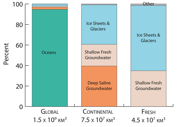
A scientific figure with three columns, comparing the relative compositions of different water reservoirs on Earth. From left to right, it shows global water, all continental water, and all fresh water. Together, shallow and deep groundwater (bottom and middle blocks in ‘continental’ column) make up around 60% of all continental water, while ice sheets are around 40%. (Credit: AGU/Geophysical Research Letters)
On Mars the search for life is linked with the search for water which, if it still exists there in liquid form, is probably buried deep in the subsurface.
Knowing the volume of Earth’s crustal groundwater, as well as the porosity of the subsurface, is also important in the production of elements that may be used in alternative energy such as hydrogen and helium, noted co-author Dr. Jennifer C. McIntosh (PhD), University Distinguished Scholar and professor of hydrology and atmospheric sciences at the University of Arizona.
Her research focus — how old the water is and where it has travelled in the subsurface — has implications in the search for safe places to store radioactive waste and carbon dioxide emissions. There must be pore space, but also the groundwater must be isolated from the rest of the environment, not actively circulating and possibly re-emerging at the surface.
McIntosh is particularly interested in the interface between actively circulating shallow groundwater and stagnant deep groundwater, which may help to reveal the bottom of the hydrologic cycle. Not only is the extent of groundwater resources a critical issue around the world she explained, “knowing the depth that you can drill to fresh and brackish groundwater is really important.” A case example is her region, southwestern USA, where recently-announced cuts in the water supply from the Colorado River mean farmers now have to rely more on groundwater.
Notably, the paper also estimates less fresh water in the ground than previous estimates suggest.
Link to the article: https://agupubs.onlinelibrary.wiley.com/doi/abs/10.1029/2021GL093549
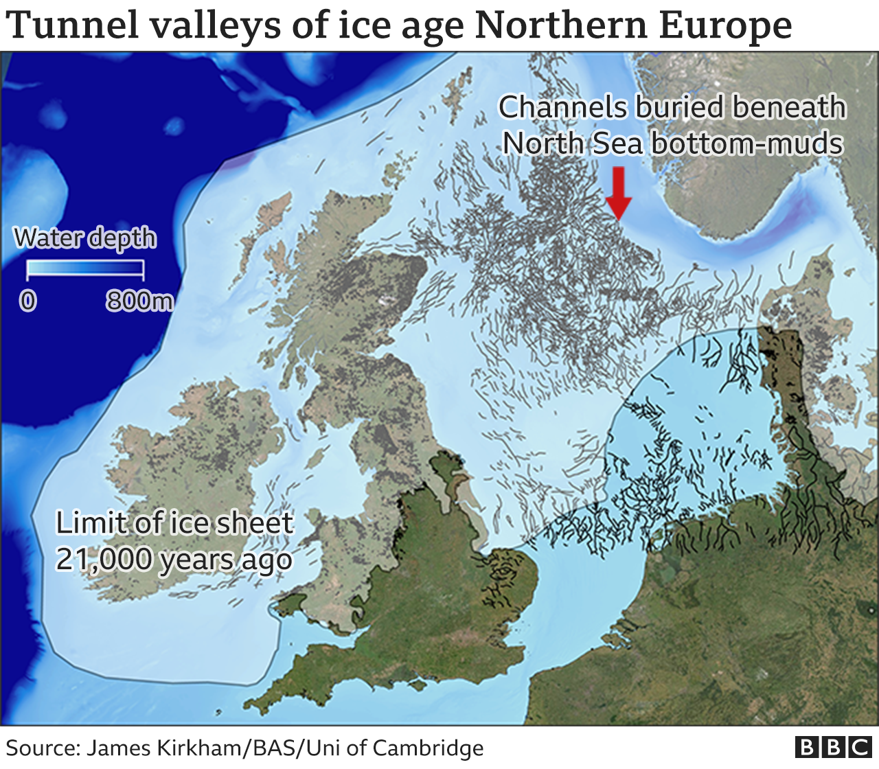
'MRI' scan reveals spectacular ice age landscapes beneath the North Sea

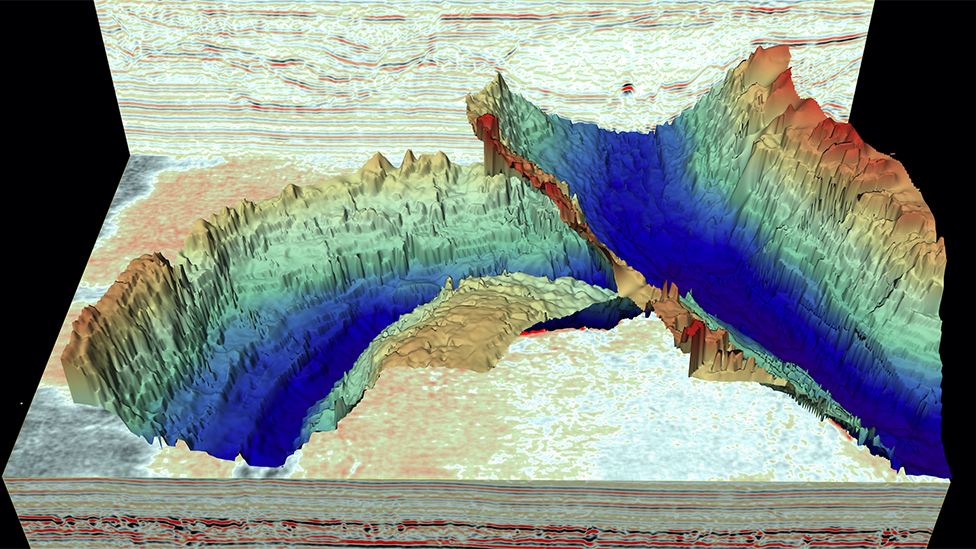
Spectacular ice age landscapes beneath the North Sea have been discovered using 3D seismic reflection technology. Similar to MRI (magnetic resonance imaging) the images reveal in unprecedented detail huge seafloor channels—each one 10 times wider than the River Thames.
For the first time an international team of scientists can show previously undetectable landscapes that formed beneath the vast ice sheets that covered much of the UK and Western Europe thousands to millions of years ago. These ancient structures provide clues to how ice sheets react to a warming climate. The findings are published this week in the journal Geology.
So called tunnel valleys, buried hundreds of meters beneath the seafloor in the North Sea are remnants of huge rivers that were the 'plumbing system' of the ancient ice sheets as they melted in response to rising air temperatures.
Lead author James Kirkham, from British Antarctic Survey (BAS) and the University of Cambridge, says:
"The origin of these channels was unresolved for over a century. This discovery will help us better understand the ongoing retreat of present-day glaciers in Antarctica and Greenland.
"In the way that we can leave footprints in the sand, glaciers leave an imprint on the land upon which they flow. Our new cutting edge data gives us important markers of deglaciation. "
Dr. Kelly Hogan, co-author and a geophysicist at BAS, says:
"Although we have known about the huge glacial channels in the North Sea for some time, this is the first time we have imaged fine-scale landforms within them. These delicate features tell us about how water moved through the channels (beneath the ice) and even how ice simply stagnated and melted away. It is very difficult to observe what goes on underneath our large ice sheets today, particularly how moving water and sediment is affecting ice flow and we know that these are important controls on ice behavior. As a result, using these ancient channels to understand how ice will respond to changing conditions in a warming climate is extremely relevant and timely."
3D seismic reflection technology, which was provided by industry partners, uses sound waves to generate detailed three-dimensional representations of ancient landscapes buried deep beneath the surface of the Earth, in a similar manner to how magnetic resonance imaging (MRI) scans can image structures within the human body. The method can image features as small as a few meters beneath the surface of the Earth, even if they are buried under hundreds of meters of sediment. The exceptional detail provided by this new data reveals the imprint of how the ice interacted with the channels as they formed. By comparing these ancient 'ice fingerprints' to those left beneath modern glaciers, the scientists were able to reconstruct how these ancient ice sheets behaved as they receded.
By diving into the past, this work provides a window into a future warmer world where new processes may begin to alter the plumbing system and flow behavior of the Antarctic and Greenland ice sheets.
"Tunnel valley infill and genesis revealed by high‑resolution 3D seismic data" is published in the journal Geology.
More information: James D. Kirkham et al, Tunnel valley infill and genesis revealed by high-resolution 3-D seismic data, Geology (2021). DOI: 10.1130/G49048.1
North Sea's hidden ice age past is revealed in 3D
Jonathan Amos
Science correspondent
@BBCAmoson Twitter
Published1 day ago
Jonathan Amos
Science correspondent
@BBCAmoson Twitter
Published1 day ago
IMAGE SOURCE,JAMES KIRKHAM
The tunnel valleys are now buried by North Sea bottom-muds, but their outline is seen in seismic data
Spectacular ice age landscapes have been revealed beneath the North Sea.
These deep, kilometres-wide channels, known as tunnel valleys, were cut by fast-flowing rivers that ran under Northern Europe's ancient ice sheets.
Today, the landforms are all hidden by the North Sea's bottom-muds, but new survey work has traced their outline in remarkable 3D detail.
Scientists say the channels should give us clues as to how modern-day ice sheets, such as Greenland, will decay.
That's because these features were all incised during periods of great melt.
"These tunnel valleys were formed during the death throes of an ice sheet in extremely warm climates," said James Kirkham, from the British Antarctic Survey (BAS) and Cambridge University.
"This makes them a great analogue for what Greenland, or even Antarctica, might begin to look like in the future, perhaps several 100 years down the line," he told BBC News.
IPCC report is 'code red for humanity'
Greenland and Antarctica ice loss accelerating
Underwater avalanche continued for two days
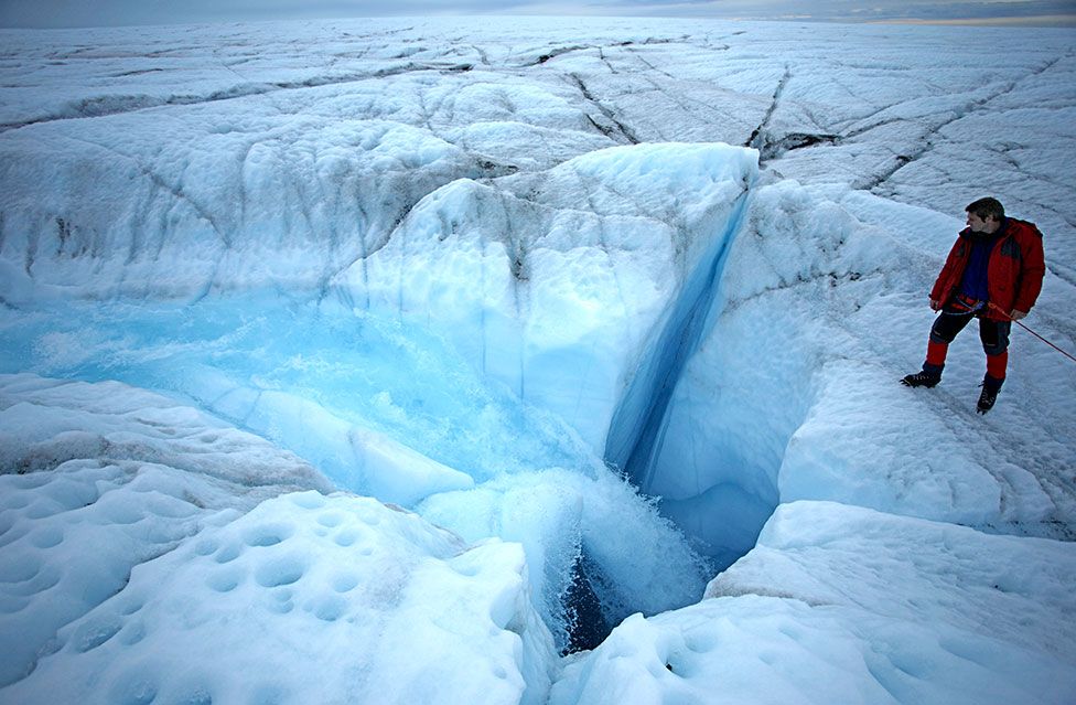
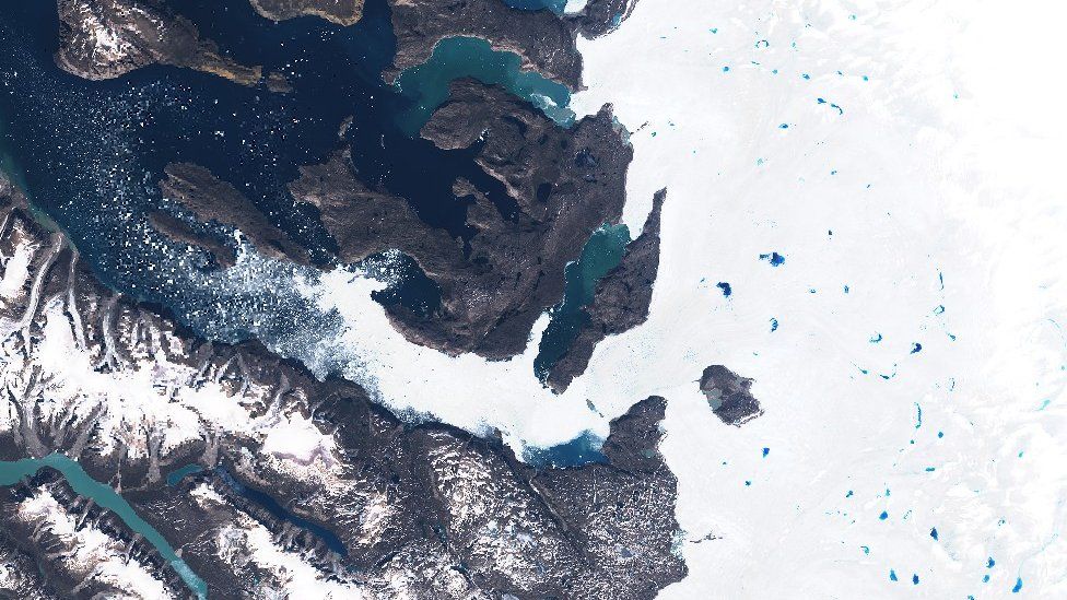
ROBBIE SHONE/SCIENCE PHOTO LIBRARY
Surface meltwater gushes down a hole to the base of the Greenland ice sheet
Today, if you visit Greenland during summer months, you'll see huge lakes of meltwater pooling on the ice sheet's surface.
This water funnels down holes to reach the bed, where it then spreads out and drains to the sea. But as it does so, this water also lubricates the flow of the ice sheet above.
Researchers have used all manner of sensors to try to understand the sub-glacial processes involved. The US space agency Nasa even sent an armada of bath-time rubber ducks on a mission to see if they could traverse Greenland's under-ice rivers.
The landforms described by Mr Kirkham and colleagues in the journal Geology provide this information in a different way - at huge scale and with super-fine resolution.
This is made possible by new seismic (sound wave) survey techniques that ordinarily would be used to image the structure of sea-floor sediments to see that they're suitable to host oil and gas, or renewables, infrastructure. But scientists can exploit that same data to recall the glacial history of the North Sea.
The past 800,000 years have seen repeated incursions of thick ice over Northern Europe during cold periods, to be followed by mass retreat when temperatures rose again. It was during the very warm phases that the tunnel valleys were cut.
James Kirkham's team describes a complex network of incisions and deposits that were made both by the rivers and by the movement of the ice on top.
These landforms include so-called eskers where water has cut a recess in the ice above which then gets filled with mud to preserve a mound - a bit like a jelly mould.
There are long sinuous ridges where sediments got squeezed into the fractures that developed in fast-flowing ice that suddenly came to a stop.
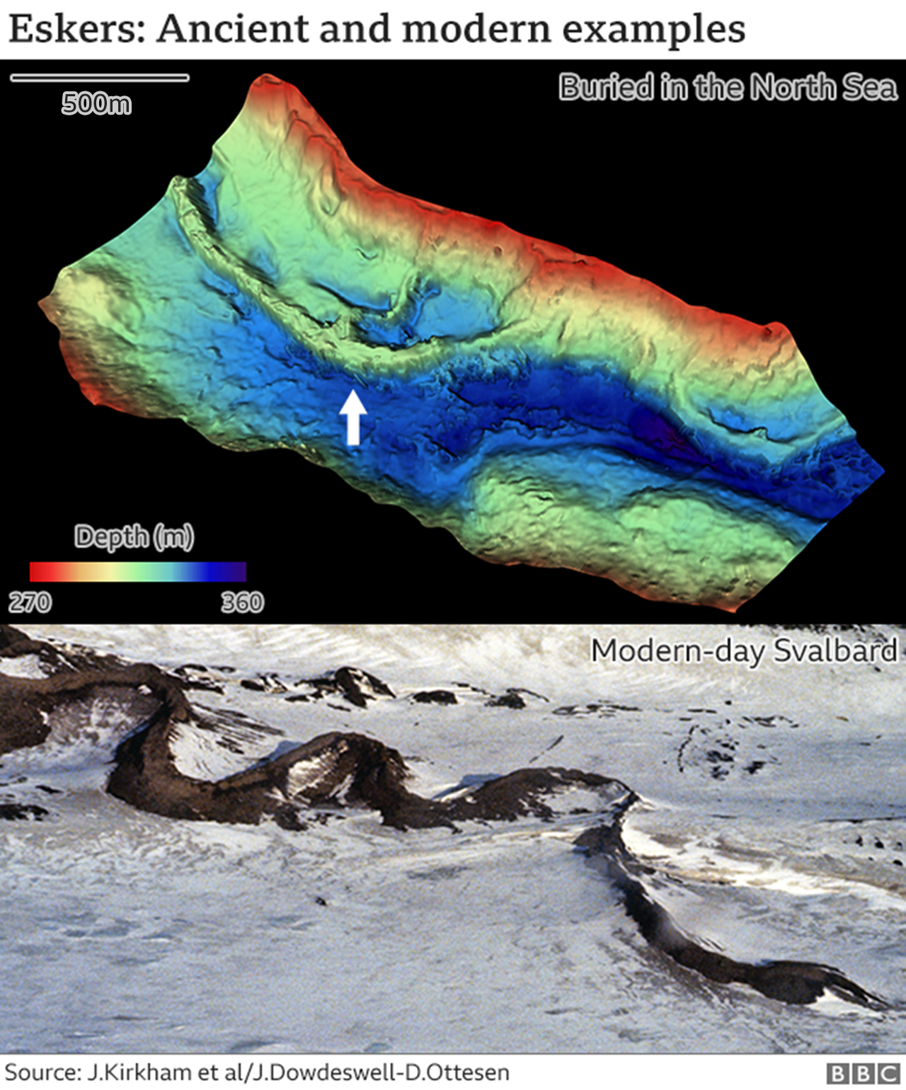
And there are even "fossil icebergs", more properly called kettle holes. These are where chunks of ice broke off the edge of a retreating sheet, got stuck in mud and then, as the blocks melted away, created voids that were later filled with a different kind of sediment to the surroundings.
"These patterns we see in the seismic data show us what the sub-glacial rivers were doing over many years, centuries even, as the ice was retreating," explained BAS co-author Dr Kelly Hogan. "And they also show us how that ice on top was behaving. We can see where it was moving quickly or where it had simply stagnated and melted away," she told BBC News.
"This is all information we need to properly model modern ice sheets, to try to understand what Greenland and Antarctica might look like in the future."
The recent state-of-the-climate report from the UN's Intergovernmental Panel on Climate Change (IPCC) said surface melting of Greenland as a result of increased air temperatures would dominate the territory's ice losses this century.
This will boost the flow of water to the sub-glacial "plumbing system" that produces the kinds of features recorded in the North Sea sediments.
Antarctica is a little different. Ice losses in the polar south are driven largely by incursions of warm ocean waters at the ice sheet's margins. Warmer air causing melting at the surface is evident in a few places but is less of a factor.
Today, if you visit Greenland during summer months, you'll see huge lakes of meltwater pooling on the ice sheet's surface.
This water funnels down holes to reach the bed, where it then spreads out and drains to the sea. But as it does so, this water also lubricates the flow of the ice sheet above.
Researchers have used all manner of sensors to try to understand the sub-glacial processes involved. The US space agency Nasa even sent an armada of bath-time rubber ducks on a mission to see if they could traverse Greenland's under-ice rivers.
The landforms described by Mr Kirkham and colleagues in the journal Geology provide this information in a different way - at huge scale and with super-fine resolution.
This is made possible by new seismic (sound wave) survey techniques that ordinarily would be used to image the structure of sea-floor sediments to see that they're suitable to host oil and gas, or renewables, infrastructure. But scientists can exploit that same data to recall the glacial history of the North Sea.
The past 800,000 years have seen repeated incursions of thick ice over Northern Europe during cold periods, to be followed by mass retreat when temperatures rose again. It was during the very warm phases that the tunnel valleys were cut.
James Kirkham's team describes a complex network of incisions and deposits that were made both by the rivers and by the movement of the ice on top.
These landforms include so-called eskers where water has cut a recess in the ice above which then gets filled with mud to preserve a mound - a bit like a jelly mould.
There are long sinuous ridges where sediments got squeezed into the fractures that developed in fast-flowing ice that suddenly came to a stop.
And there are even "fossil icebergs", more properly called kettle holes. These are where chunks of ice broke off the edge of a retreating sheet, got stuck in mud and then, as the blocks melted away, created voids that were later filled with a different kind of sediment to the surroundings.
"These patterns we see in the seismic data show us what the sub-glacial rivers were doing over many years, centuries even, as the ice was retreating," explained BAS co-author Dr Kelly Hogan. "And they also show us how that ice on top was behaving. We can see where it was moving quickly or where it had simply stagnated and melted away," she told BBC News.
"This is all information we need to properly model modern ice sheets, to try to understand what Greenland and Antarctica might look like in the future."
The recent state-of-the-climate report from the UN's Intergovernmental Panel on Climate Change (IPCC) said surface melting of Greenland as a result of increased air temperatures would dominate the territory's ice losses this century.
This will boost the flow of water to the sub-glacial "plumbing system" that produces the kinds of features recorded in the North Sea sediments.
Antarctica is a little different. Ice losses in the polar south are driven largely by incursions of warm ocean waters at the ice sheet's margins. Warmer air causing melting at the surface is evident in a few places but is less of a factor.
IMAGE SOURCE,SENTINEL HUB
Blue meltponds form on the surface of the Greenland ice sheet in summer months
Subscribe to:
Posts (Atom)