Showing posts sorted by date for query CHINA. Sort by relevance Show all posts

Sunday, September 06, 2026

How China’s Paracel expansion extends its military reach towards Vietnam

China is rapidly expanding two artificial islands in the disputed Paracel Islands, with analysts saying the new facilities could strengthen Beijing’s military reach towards Vietnam and along key South China Sea shipping routes.


Issued on: 04/09/2026 - RFI

Satellite image dated 17 August 2026 showing an artificial island built by China in the disputed Paracel Islands in the South China Sea. © Satellite image ©2026 Vantor

In just a few months, China has transformed two previously unused sandbanks into artificial islands bearing the hallmarks of military installations. After building around 20 outposts across the South China Sea since 2013, Beijing has resumed construction in waters disputed by several of its neighbours, notably Vietnam.

A mysterious triangular concrete structure, a harbour and a long strip of reclaimed land resembling a runway have emerged since China began major dredging and construction work in the Paracels in December 2025.

Satellite imagery analysed by the Asia Maritime Transparency Initiative (AMTI) shows the rapid transformation of two sandbanks that Beijing had previously left undeveloped.

“We cannot say for certain yet, but all the evidence suggests that China is building a very large military base on Antelope Reef,” Harrison Prétat, deputy director and researcher at AMTI, a project funded by the Washington-based Centre for Strategic and International Studies, said.


Possible military base

Across roughly six square kilometres in the heart of the South China Sea, sand has been covered with concrete and sections of coral reef appear to have been cleared to accommodate the steady movement of ships.

Military analysts are closely watching the work, although the precise purpose of the new facilities remains unclear.

“On Yagong Island, 14 kilometres from Antelope Reef, it looks like support facilities for the military base,” Prétat said. “The most likely scenario would be the construction of detection and radar equipment to support the base at Antelope.”

Much of the attention has focused on a large triangular concrete structure at the centre of the small island, which analysts believe could eventually house surveillance equipment.

That interpretation would fit with Beijing’s broader network of strategic outposts along major commercial and military routes.

“It’s like a fortress in the desert,” said Hugo Tierny, a military historian at the École pratique des hautes études and researcher at France’s Institute for Strategic Research, Irsem.

“It provides a permanent location for monitoring movements, a harbour for ships, facilities for launching aircraft, and all of it monitored by radar.”

Between 2013 and 2017, Beijing sharply expanded its network of outposts as it sought to reinforce its claims over the South China Sea, more than 90 percent of which it considers its own.

AMTI said China already operates around 20 militarised outposts in the Paracels, which are also claimed by Vietnam, compared with seven in the Spratly Islands closer to the Philippines.

Until now, many Chinese installations have followed a relatively standard pattern.

“China has been carrying out a sort of ‘copy-and-paste’ of facilities across its various outposts,” Prétat said. “But what we are seeing on Yagong Island does not exactly resemble any type of structure already seen in the South China Sea.”

Vietnam in view

If construction continues at its current pace, the function of the new structures may soon become clearer. Their location, however, already offers clues to Beijing’s intentions.

Around 400 kilometres off the Vietnamese coast and roughly midway between the Taiwan Strait and the Strait of Malacca – two of Asia’s most strategically sensitive maritime chokepoints – China is creating what would be the second-largest artificial island in the Paracel archipelago.

Vietnam, which claims sovereignty over the islands, has demanded that Beijing “immediately halt construction”, describing the work as “illegal”.

Hanoi has traditionally been less outspoken than Manila in challenging China’s activities in the South China Sea. But while maintaining close relations with Beijing, Vietnam has also pursued a more assertive strategy of its own.

It has built around 20 artificial islands, increased defence spending and diversified its military partnerships, including with Russia, the US and France.

“The main purpose of new detection equipment at this location is to have more sensors directed directly towards Vietnam,” Prétat said.

“Nothing obstructs the equipment’s ability to scan the maritime area as far as the Vietnamese coast. This provides a clear line of sight that is slightly different from those they already have.”

The site could also strengthen China’s ability to support its coastguard presence in the area, resupply vessels and reinforce its claim of sovereignty – particularly towards Vietnamese fishermen and sailors operating nearby.

Wider regional strategy

The new installations also form part of a wider strategic calculation involving Washington.

“The Chinese are continuing their policy of developing strategic depth to the south of their coastline,” Tierny said. “In the event of regional escalation, they believe, in particular, that this will hinder the US Navy’s access from the south and strengthen their defensive perimeter.”

Each additional base also offers China another potential logistical and military fallback point.

Although the Paracels lie more than 1,000 kilometres from Taiwan, a stronger Chinese foothold in the area could prove valuable in the event of a wider regional conflict – particularly if Beijing were to attempt the “reunification” with Taiwan repeatedly advocated by Chinese President Xi Jinping through military force


This article was adapted from the original version in French by RFI's Nicolas Rocca

 'We are family', says EU chief Ursula von der Leyen at start of Greenland visit


European Commission president Ursula von der Leyen arrived in Greenland on Sunday for a two-day visit aimed at reaffirming the bloc's support for the Arctic island coveted by the US President Donald Trump.


Issued on: 06/09/2026 - RFI

Denmark's Prime Minister Mette Frederiksen (left) and Greenland's head of government Jens-Frederik Nielsen (centre) met European Commission president Ursula von der Leyen (right) at the start of her two-day visit to Greenland. 
Mads Claus Rasmussen/Ritzau Scan - 


"We are family," she said on her arrival in the island's capital, Nuuk, where she was welcomed by Greenland's Prime Minister Jens-Frederik Nielsen and his Danish counterpart Mette Frederiksen.

Throughout her trip, von der Leyen will send the message that the Danish autonomous territory belongs with Europe rather than the US.

Her agenda includes a boat outing amid the icebergs, meetings top Greenlandic and Danish officials and signing a joint statement between Greenland and the EU.

US security plan for Greenland


Trump insisted earlier this year that Washington needed to control Greenland for national security reasons, though he ultimately ruled out annexing it by force.

A Danish-Greenlandic-US working group has since met regularly to find a way of cooperating in the future.

Following Trump's threats, European countries as well as Canada backed Denmark and Greenland.

In January, von der Leyen vowed there would be massive EU investment in Greenland to step up security in the Arctic.

Brussels has proposed doubling direct EU aid to Greenland to €530 million under the 27-nation bloc's next budget for the 2028-2034 period.

According to the British newspaper Financial Times, von der Leyen is expected to propose an additional €200 million in support during her visit on Sunday and Monday.

"Europe is delivering," she said. "We are expanding our cooperation to new areas, from better, faster connectivity and clean energy to critical raw materials."
10-nation military exercises

Von der Leyen's visit coincides with the start of Nato's Arctic Shield military exercise, bringing together soldiers from 10 countries.

The Trump administration has repeatedly accused Denmark of neglecting Greenland and Arctic security.

However, Copenhagen has since reinvested in the region, as has Nato, which launched its Arctic Sentry mission at the start of the year.

"Greenland is becoming increasingly important to the EU as a gateway to the Arctic and because of its geopolitical location, critical raw materials and role in Arctic security," Marc Jacobsen, a researcher at the Royal Danish Defence College, told the French news agency AFP ahead of the visit.

"We've been getting 'postcards' from Trump or those close to him about Greenland every month, showing that they haven't forgotten," said Mikaa Blugeon-Mered, a geopolitics researcher at the University of Quebec.

One such image Trump posted on social media in May showed him peering over the island, with the headline: "Hello, Greenland!"

Last month, media reports of an American oil company's preparatory operations in a remote region of eastern Greenland rekindled concerns on the island.

The project, run by a Texas-based company with licences granted before a 2021 moratorium on oil and gas exploration and extraction, has left locals and authorities uneasy.

Authorities have yet to grant the company approval for exploratory drilling, citing procedural reasons.

Greenland, home to 57,000 inhabitants, is also struggling to develop its mining industry, which could help it fund its independence from Denmark.

But turning Greenland's geological potential into reality is proving more difficult than expected. Around 135 mining permits are held by more than 60 companies, but only two mines are currently in operation.

EU chief von der Leyen heads to Greenland in show of support for the island


By Nathan Rennolds
Published on

Speaking at the World Economic Forum's annual meeting in Davos this year, von der Leyen said the EU was working on a "massive European investment surge" in Greenland in a bid to ramp up Arctic security.

European Commission President Ursula von der Leyen is visiting Greenland on Sunday and Monday as the bloc signals its continued support for the island amid US President Donald Trump's repeated calls for the United States to acquire it.

As part of the visit, von der Leyen is expected to sign a joint declaration between the EU and the Danish autonomous territory on Monday.

Since his return to the White House in January last year, Trump has claimed the US needs to take control of Greenland for its "national security," arguing that either China or Russia would otherwise seize the island.

Von der Leyen and European Council President António Costa issued a joint statement in January in which they highlighted the importance of "territorial integrity and sovereignty" and said the EU stood "in full solidarity with Denmark and the people of Greenland."

Speaking at the World Economic Forum's annual meeting in Davos this year, von der Leyen said the EU was also working on a "massive European investment surge" in Greenland in a bid to ramp up Arctic security.

The Commission has proposed allocating €530 million to Greenland under its budget for the 2028–2034 period, which it said reflected its "growing geostrategic importance in the Arctic."

The Financial Times reported that von der Leyen is set to announce an additional €200 million in funding for the island during her visit.


Houses are seen near the coast of a sea inlet of Nuuk, Greenland, on Sunday, Jan. 25, 2026. Copyright 2026 The Associated Press. All rights reserved

In May, Trump's special envoy to Greenland, Jeff Landry, said it was time the US "puts its footprint back" on the territory.

Landry, who is also the governor of Louisiana, made the comments during a trip to the territory, his first since his appointment to the special envoy role in December 2025.

Speaking from Greenland's capital, Nuuk, Landry told Agence France-Presse: "I think that you're seeing the president talk about increasing national security operations and repopulating certain bases in Greenland."

"Everyone that I've talked to in Greenland would love to see the US repopulate those bases," he continued, adding that the territory "needs the US."

In January, the leaders of five political parties in Greenland’s parliament released a joint statement with a clear message to the US.

"We do not want to be Americans, we do not want to be Danes; we want to be Greenlanders," it read.

The US is reported to have had 17 military facilities and more than 10,000 troops on Greenland at the height of the Cold War. It currently operates just one base on the island, the Pituffik Space Base - the US Department of Defense's northernmost installation.

Pituffik is used for missile warning, missile defense and space surveillance missions, according to the US Space Force.


Oil use and emissions fell in China as Iran war curbed imports. Will it be a lasting change?

FILE - A boy cycles past a cooling towers of a coal-fired power plant in Dadong, Shanxi province, China, 3 Dec. 2009.
Copyright AP Photo/Andy Wong, File


By Angela Symons with AFP
Published on

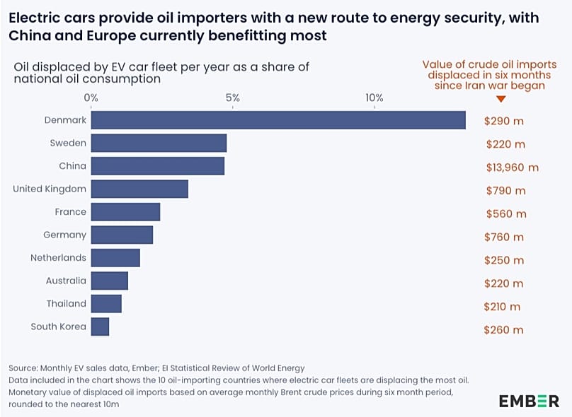
This is the first time that reductions in oil consumption – rather than coal – have been responsible for a drop in China's CO2 emissions.

China's carbon dioxide emissions fell in the second quarter of the year, new analysis shows.

The country's emissions have fallen before, but this was the first time it was driven by lower oil consumption – with a "dramatic fall" in China’s demand for oil imports following Middle East shipping disruptions linked to the US-Iran war.

Planet-warming CO2 emissions were down one per cent in the April-June period, according to the Centre for Research on Energy and Clean Air (CREA) analysis published by Carbon Brief.

Oil use fell nine per cent overall and 16 percent for transport, based on assessments of Chinese government data.

The situation "has very clearly validated China's energy security strategy and especially the role of electrification as a part of that strategy", says CREA co-founder and lead analyst Lauri Myllyvyrta.

Restricted oil imports have sped up electrification in China

Severe disruption to traffic through the crucial Strait of Hormuz – which was previously used to transport 20 per cent of the world's oil and gas – has heavily impacted shipments of oil to China, the world's second-largest economy and the top importer of crude.

Now, more than six months into the US-Iran war, China has weathered the complications more smoothly than many experts initially anticipated.

Myllyvirta says that the crisis has accelerated adoption of electric fleets in China across traditionally gas-guzzling industries including construction and mining.

"These kinds of changes are highly likely to prove sticky," he says.

Electric heavy-truck sales rose by about 77 per cent in the second quarter year-on-year, while the number of EVs on the road grew by 33 per cent and charging volumes rose by 60 per cent, indicating increased utilisation of existing EVs.

Previous drops in China's emissions have been driven primarily by lower coal consumption, rather than oil, according to the CREA.

Solar has surpassed coal in the world's biggest emitter

China is the world's biggest emitter, responsible for over 30 per cent of global greenhouse gases.

Its leaders have promised to step up efforts to reduce CO2 and boost the green transition, aiming for carbon neutrality by 2060.

While emissions fell in the second quarter, they rose two per cent in the first, according to the CREA data, leaving levels "up marginally across the first half of the year".

Earlier this week, Chinese authorities said that the country's installed solar energy capacity had surpassed that of coal-fired power for the first time.

China has seen explosive growth in renewable installation, with coal's share in its energy mix edging down in recent years.

Still, emissions from the power sector rose between April-June due to increased coal use, while gas-fired generation fell. This is despite strong growth in wind and solar capacity, with “wasted” power a persistent problem linked to a grid not adapted to increasing shares of variable renewable generation.

Sweet-stealing capitalists and the definition of kissing: The 2026 Ig Nobel award winners

Fungi was the theme of this year's event, which was held in Zurich, Switzerland
Copyright Eric Workman/Improbable Research - Canva

By David Mouriquand
Published on

The annual awards highlight strange, funny and thought-provoking research. This year's ceremony took place in Europe, with “fungi” as the theme of the 36th edition.

Nobel prize winners get prestige, a gold medal, and a little over a million dollars. Ig Nobel prize winners don’t get such sublime considerations.

They do get acclaim, but instead of all the Nobel perks, they are instead showered with paper planes and 10 trillion Zimbabwean dollars.

The snag is that the currency cratered years ago, so 10 trillion Zimbabwean dollars is worth next to nothing. Still, last year’s winners went home with a single packaged moist towelette, so swings and roundabouts... Plus, this year's winners were given a statuette representing a slab of blue cheese trampled on by a foot erupting with toadstools in honour of this year's “fungi” theme. What's not to love?

Established in 1991 as a satirical version of the Nobel prize, the Ig Nobels aim to promote public engagement with scientific (and culturally resonant) research, honouring “achievements that first make people laugh, and then make them think".

This year’s Igs were awarded yesterday at a ceremony in Zurich, Switzerland – a first, as the award ceremony is usually held in the US. The reason, the organisers say, comes down to the hostile climate in the US toward science, as well as international travellers being increasingly reluctant to travel Stateside.

A perfectly ordinary and not at all alarming English sentence.

“During the past year, it has become unsafe for our guests to visit the country,” Marc Abrahams, master of ceremonies and editor of The Annals of Improbable Research magazine, told AP. “We cannot in good conscience ask the new winners, or the international journalists who cover the event, to travel to the US this year.”

Back to this year's research and winners, who have discovered that the upper classes are more prone to behaving badly, that kissing can be redefined and cockroaches will inherit the Earth in more ways that one.

Here's a look at some of this year’s winners:

Biomechanics: Evolutionary smooching

Evolutionary smooching
Evolutionary smooching Canva

Winners: Matilda Brindle, Catherine Talbot, Stuart West (UK, USA).

Rationale: "Devising a more precise definition of kissing – non-agonistic interactions involving directed, intraspecific, oral-oral contact with some movement of the lips/mouthparts and no food transfer" – in ants, polar bears, and humans.

Research: A comparative approach to the evolution of kissing. Dr Matilda Brindle and her colleagues developed a rigorous definition of kissing through the study of different species. They found that kissing occurs in most living large apes and likely in Neanderthals - arguing that early humans and Neanderthals may have even kissed one another. "Next time you kiss someone, you can think, 'This is a 21.5 million-year-old tradition that I'm honoring here,” said Dr Brindle. “It's not just a modern human behaviour. It's really ancestral. And to us, that suggests that it probably has quite a useful evolutionary function."

Economics: Rich people are the worst

Why would you?
Why would you? Canva

Winners: Paul Piff, Daniel Stancato, Stéphane Côté, Rodolfo Mendoza-Denton, and Dacher Keltner (USA, Mexico, Canada)

Rationale: "Amassing evidence that upper-class people are more likely to snatch from a children's candy, and engage in other kinds of unethical behaviour."

Reasearch: Higher social class predicts increased unethical behaviour. The researchers amassed evidence through seven studies that prove rich people are just the worst. They’re more likely to take sweets from children, excel at lying when it comes to their scores during dice rolls, are more likely to cut other cars off at junctions, and view greed as a positive attribute. “The general pattern seems to be that with wealth and rising power, you become less engaged with the needs of others and less burdened by the needs of social relationships,” Piff said. “Taking candy from children might be the least of our worries but it’s emblematic of the tendency to prioritise one’s own needs over those of others.”

Turns out Dorothy Parker was right: “If you want to know what God thinks of money, just look at the people he gave it to."

Chemistry: Cockroach milk, anyone?

Got milk?
Got milk? Canva

Winners: Sanchari Banerjeee, Nathan Coussens, Francois-Xavier Gallat, Nitish Sathyanarayanan, Jandhyam Srikanth, Koichiro Yagi, James Gray, Steven Tobe, Barbara Stay, Leonard Chavas, Sumabramanian Ramaswamy (India, France, Japan, USA).

Rationale: "Discovering that milk proteins from vivaporous cockroaches contains three times as much energy as milk proteins than from cows."

Research: Structure of heterogeneous, glycosylated, lipid-bound, in vivo-grown protein crystal at atomic resolution from the viviparous cockroach Diploptera punctata. If that sentence just gave you a headache, it boils down to the authors extracting milk crystals from the guts of Diploptera punctata roach embryos harvested from a brood sac to determine the protein structure of the crystals. Essentially, cockroach milk is powerful.

Physics: The optimization of urination

No more splash back
No more splash back Canva

Winners: Randy Hurd, Zhao Pan, Tadd Truscott, Kaveeshan Thurairajah (Canada, USA, China, Saudi Arabia).

Rationale: "Theoretical and experimental attempts to design a splash-free urinal."

Research: Splash-free urinals for global sustainability and accessibility. A team of students at the University of Waterloo in Canada worked out that urinal splash is almost entirely eradicated if the stream strikes the urinal at less than 30 degrees. They even designed a urinal whose shape ensures minimal splash regardless of the user’s aim. “I am very proud,” said Dr Zhao Pan. So he should be.

Medecine: Thrusting mucus

The culture and science of blowing
The culture and science of blowing Canva

Winner: Takuji Unno (Japan).

Rationale: "How to Blow the Nose – An Aerodynamic Study of the Nose Blowing."

Research: Unno explored the cultural differences between Europeans and Japanese people when it comes to proper nose-blowing, quantifying the key aspects of the practice “to give good instructions to those who do not understand how to blow the nose.” He concluded that the faster the “expiratory thrust” of the blow, the more efficiently one can expel mucus. “A big and long nose blow is therefore recommended to prevent upper and lower respiratory tract diseases.”

Peace: The benefits of vicious friends

The benefits of vicious friends
The benefits of vicious friends Canva

Winners: Jaimie Arona Krems, Rebecka Hahnel-Peeters, Laureon Merrie, Keelah Williams, and Daniel Sznycer (USA, Argentina, Australia).

Rationale: "We value friends who are vicious to people we dislike."

Research: People have nuanced preferences for how they want their friends to behave toward them versus others. No one likes a friend who treats them poorly; but in a broader social context, the authors explored how dynamics shift when it comes to how people want their friends to behave toward their enemies. In those cases, some prefer their friends to be more vicious toward those people. “Sometimes we want our friends to be more vicious and indifferent when they interact with our enemies,” said Dr Jaimie Krems. “I’ve felt, in many instances, incredibly loved when people have carried my hate for me and been willing to have my back.”

Olfaction: Smelly children

Damn hormones
Damn hormones Canva

Winners: Ilona Croy, Tomasz Frackowiak, Thomas Hummel, and Agnieszka Sorokowska (Poland, Germany, Sweden).

Rationale: "Collecting evidence that babies smell wonderful to their parents but teenagers do not."

Research: "Babies Smell Wonderful to Their Parents, Teenagers Do Not: an Exploratory Questionnaire Study on Children’s Age and Personal Odor Ratings in a Polish Sample." Conclusion: Parents usually find their babies’ body odour very pleasant, as it activates reward centers in the brain. However, once puberty hits, it’s a different matter. Bloody hormones.

Elsewhere, other researchers landed prizes for turning mosquito proboscises into 3D printing nozzles, burying cotton underwear to monitor soil quality, and gently stepping on various parts of snakes to try to learn what induces a venomous snake to bite a human. They're more likely to bite during the day, in warmer climates, and if you trample their head. And before you ask, yes, they wore safety boots.

Next year’s Ig Nobel ceremony will be held in Antwerp, Flanders.

Additional sources 

 UN backs effort to drop Mercator map and show size of Africa more accurately


The United Nations voted on Saturday for a shift away from the 16th-century Mercator global map towards one more accurately reflecting the true size of countries.


Issued on: 05/09/2026 - RFI

The UN General Assembly adopted a resolution to promote a global map that more accurately reflects the actual size of the continents, notably enlarging Africa and reducing the size of the United States. © Studio graphique FMM

The resolution was sponsored by African states to counter perceptions that the continent is peripheral.

It passed with the support of 164 nations, including France. The United States was the only vote against the move. Estonia, Georgia, Lithuania, Moldova, Serbia and Ukraine abstained.

Togo led the initiative to further the African Union campaign to limit use of the Mercator projection, named after a 16th-century Flemish cartographer Gerardus Mercator.

Designed for maritime navigation, it increases distortion the further a region lies from the equator.

Since Africa and South America both straddle the equator, they seem smaller than their actual size, while Russia, North America and Greenland appear much larger.

"The United States, Russia and China take on a disproportionate visual importance compared with Africa, Latin America or South-East Asia," said France's Foreign Minister Jean-Noël Barrot when he announced on Friday that France will stop using maps based on the Mercator projection.

"Greenland appears almost as large as Africa, whereas Africa is actually about 14 times larger."


Equal Earth projection

The resolution promotes the Equal Earth projection, which more accurately portrays the size of the continents. It is not legally binding.

"It in no way challenges the use of the Mercator projection for maritime and aerial navigation, for which it remains fully suited," the Togolese ministry said in a statement.

“This decision is about much more than cartography," said Togo's Foreign Minister Robert Dussey on social media after the resolution was adopted.

"It is about justice, dignity, equality and the way we represent our world.”

The US delegation said it objected to the resolution because it promoted an ideological agenda. "It is a distraction from the genuine problems of international peace, prosperity or good relations," it added.


'Togo to change maps in schools'

"Togo will be the first country to change our own geography books," Dussey said.

"In the classroom, we need to change it to give an example to all the countries in the world."

Dussey said Togo will press other governments, schools, international organisations and technology companies to move away from the Mercator projection.

He added that Togo plans to meet African Union member states and supporters from other regions within the next six months to agree on how to promote wider adoption.

Dussey said the discussion about next steps would need to include companies operating mapping, GPS and other location-based technologies.

The text of the resolution did noto ban the Mercator projection outright. It asks governments, schools, international organisations and technology companies to adopt the Equal Earth projection and other equal-area maps where the true scale of continents matters.


Changing perceptions

Barrot said in his speech at the Sorbonne University in Paris that France's decision was part of a wider debate about how maps shape perceptions of international power.

Such representations can have a lasting effect on how people perceive the world, he argued.

"Distortions eventually take root in perceptions. The time has come to correct them," Barrot said. "Changing the map obviously does not change the world. But correcting a distorting representation is already an act of truth."

Barrot said the move was in line with France's push against over-simplified views of the world that pit a so-called "global south" against "the West" and portray Europe as being in decline.


African campaign

In a briefing to the African Group at the UN about changing the map, Dussey said: "A map is never neutral ... It shapes perceptions, influences how the place of peoples and continents in the world is understood, and may, sometimes from the earliest years of schooling, perpetuate representations that do not correspond to geographic reality."

"Africa is not asking for preferential treatment," he added. "Africa is asking that its reality, aspirations and contribution to the international system be duly taken into account."

(with newswires)


Paris drops Mercator projection: France now looks smaller on world maps

Foreign Ministry
Copyright MAE\

By Alexander Kazakevich
Published on

France is redrawing its world map: deeming the Mercator projection misleading, the foreign ministry will drop it in favour of a map that better reflects actual continental sizes, especially Africa.

A shrunken Africa, a Greenland and a northern Russia that seem to stretch into infinity: that is about to disappear from the maps used by French diplomacy.

Foreign Minister Jean-Noël Barrot announced on Friday that his department is abandoning the so-called Mercator projection, which artificially enlarges polar regions and visually downplays the size of equatorial areas. France will now use instead the Eckert IV projection, which reflects the true proportions of the continents more accurately.

As a result, France will appear smaller on the map compared with countries close to the equator, just like the United States or Russia.

'A map is never entirely neutral'

In a speech at the Sorbonne university during the public event "La Fabrique de la diplomatie" or "The making of diplomacy", the French minister said that "the time has come" to "correct" how the world is perceived through maps inherited from 16th-century Western navigators.

In a speech delivered at the Sorbonne for the public event "La Fabrique de la diplomatie", the French minister said that "the time has come" to "correct" how the world is perceived through maps inherited from 16th-century Western navigators.

"A map is never entirely neutral. Take the Mercator projection, the one every one of us has known since childhood. The areas we see on it do not correspond to actual areas: (...) The United States, Russia, China take on a disproportionate visual importance compared with Africa, Latin America or South-East Asia," the French foreign minister said.

Jean-Noël Barrot also cited the example of Greenland, which is roughly the same size as the Democratic Republic of Congo or Algeria, even though it "seems almost as vast" as the entire African continent.

"Changing the map obviously does not change the world. But correcting a representation that distorts it is already an act of truth," he stressed.

The ministry began reducing its use of the Mercator projection in 2021

Meanwhile, French diplomatic maps will not change overnight but the process is already underway, Euronews has learned from a diplomatic source. The ministry began reducing its use of the Mercator projection in 2021, "with the aim of providing a more accurate geographical representation of the world."

The projection has been "gradually phased out" across all public diplomacy websites, the source said.

"The advantages and biases associated with each type of representation are presented at various events attended by the ministry's cartographers," the Quai d'Orsay added, citing the European Heritage Days and the International Geography Festival in Saint-Dié-des-Vosges.

"France will continue this work, prioritising map projections suited to different purposes and providing a more accurate reflection of geographical realities in its diplomatic communications."

French diplomats nevertheless acknowledge that the Mercator projection remains relevant "in a limited number of cases", including regional or local uses around the equatorial zone, as well as for navigation charts.

At the UN, a cartographic victory for Africa

The announcement in Paris comes as, in New York, the world map is also being redrawn. A few hours later, the United Nations General Assembly officially abandoned the Mercator projection in favour of a projection based on the Equal Earth model, created in 2018 and closer to the real proportions of the continents.

The non-binding resolution, entitled "Correcting the map"and sponsored by Togo, was backed by 164 member states. The African Union had already adopted Equal Earth in March, and the text now encourages countries to do the same.

Only the United States voted against, denouncing what it called a "radical ideological project", notably because of a passage in the resolution stating that "correcting cartographic distortions relating to the size of continents constitutes an act of cognitive justice and memorial reparation".

Six countries – Estonia, Georgia, Lithuania, Moldova, Serbia and Ukraine – abstained.

The United Nations General Assembly adopts an African proposal for a new world map In favor: 164 Against: 1 Abstentions: 6

The UN stresses that the resolution does not ban the Mercator projection, "nor does it impose a single map". The resolution "encourages governments, educational institutions, international organisations and technology companies to make use of the Equal Earth projection, or of other so-called 'equal-area' maps that preserve the true proportions of surface areas.

France has therefore joined this movement, but has opted to adopt the Eckert IV projection, created in 1906. It is similar to the Equal Earth projection recommended by the UN, though not identical. Both represent the size of the continents much more faithfully than the Mercator projection, but they differ slightly in the shapes they give to the landmasses.

As the UN points out, Mercator mapping will not disappear altogether. Digital platforms such as Google Maps also currently use a version of this projection.

In French schools, most world maps are still in Mercator. "You can find Eckert or Peters* in some textbooks, but that is very rare," says Grégory, a senior history and geography teacher in Rennes, speaking to Euronews.

It remains to be seen whether the maps used in schools will also follow the shift launched by the foreign ministry.

*another equal-area projection, which provides a better representation of the continents' true surface area – Euronews.


Ukraine abstains as the UN adopts a world map that shades Crimea differently

Ukraine abstains as the UN adopts a world map that shades Crimea differently
The Equal Earth projection the General Assembly adopted to stop Africa looking small also shows occupied Crimea in a lighter shade than the rest of Ukraine, and Kyiv says that opens a Pandora's box / bne IntelliNewsFacebook
By Ben Aris in Berlin September 6, 2026

Ukraine abstained from the UN General Assembly resolution adopting a new world map, because the map it endorses shows occupied Crimea in a lighter shade than the rest of Ukraine.

The resolution, tabled by Togo and carried as draft 80/L.104, commits the UN to the Equal Earth projection in place of the Mercator, on the argument that Mercator makes Africa look far smaller than it is. On the version circulated with the vote, Crimea is rendered in a distinctly lighter shade than mainland Ukraine. No comparable marking is applied to Russian-occupied parts of Georgia or Moldova.

A cartographic convention is not usually a diplomatic problem, and the UN has passed a series of resolutions since 2014 treating Crimea as Ukrainian territory under occupation. A UN map that shades it differently sets those two positions against each other in a document every member state has now voted on.

"Such a misinterpretation could open a Pandora's box, effectively facilitating abuses and distortions of the political map of the world," Ukraine's permanent mission to the UN said, adding that it supports correcting the historical distortions of scale but opposes cartographic breaches of the UN Charter and international law, the Kyiv Post reported.

Kira Rudik, the Ukrainian MP who leads the Golos party, put it more bluntly. "Ukraine could not support the UN resolution on a new world map because it depicts occupied Crimea in a way that separates it from Ukraine," she said. "In 2026, the UN should not need a reminder: Crimea is Ukraine."

What has irritated Kyiv most is that its allies did not notice. "Was everyone asleep at the UN Secretariat and at UN missions of European nations?" asked Yaroslav Trofimov, the Ukrainian-born journalist and author. "Nobody in France, UK, Germany, Canada, even Latvia, noticed that they are voting not just for a more accurate map projection of Africa but also for a map showing Crimea detached from Ukraine, in contravention of all previous UN resolutions?"

The resolution passed. Ukraine did not vote against it.