It’s possible that I shall make an ass of myself. But in that case one can always get out of it with a little dialectic. I have, of course, so worded my proposition as to be right either way (K.Marx, Letter to F.Engels on the Indian Mutiny)
Explainer: Why does Germany rely heavily on voluntary fire services?
In Germany, volunteer firefighters perform the bulk of rescue operations, as the recent floods showed. That’s because full-time fire services are expensive to maintain.
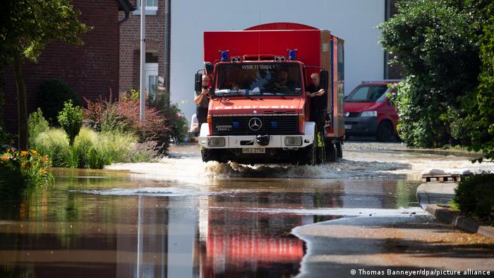
Voluntary fire services are at the forefront of rescue operations in Germany's devastating floods
Fire brigades usually carry out rescue and recovery operations, extinguish fires and protect life and property. In much of Germany, however, this work is mainly performed by volunteers who often have a normal, paid job.
The volunteers carry a pager with them at all times that alerts them when there is an emergency. When it beeps, they quickly head to the local fire station and then to the scene of the emergency.
This is because most small towns and villages in Germany cannot afford a full-time fire brigade since equipment and personnel are expensive to buy and maintain. That means full-time professional fire services are often stretched thin in many regions and they can't be relied on to attend to each emergency, especially since they could be far away and need a long time to reach the site.
Volunteer firefighters play a crucial role in areas where professional fire brigades are stretched thin
In large cities, that is those with more than around 100,000 inhabitants, there are also professional fire departments. According to statistics from 2018, there are 104 of these in the country. But they too are often supported by volunteers. There are more than 22,000 voluntary fire services in Germany and their ranks are steadily rising.
Being part of a voluntary fire service, however, is not a hobby. Volunteers are required to take courses and participate in extensive and regular training to be able to actively fight fires or get a grip on challenging situations such as a flood disaster. They usually undergo training in their free time.
However, if there aren't enough volunteers to staff a fire brigade, a compulsory fire service is deployed. Residents between the ages of 18 and 50 are required to get trained and temporarily do the work of the fire service.
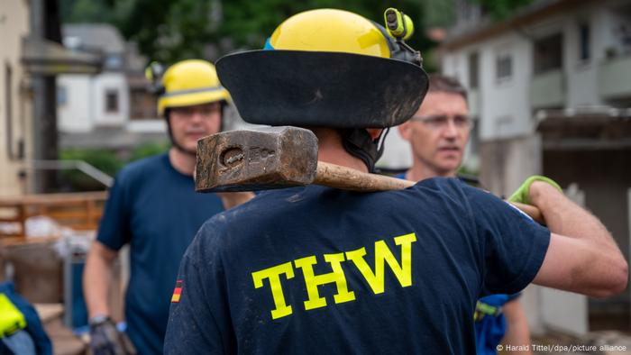
Germany's THW service is a familiar sight during emergency situations such as floods or landslides
Another organization that is similar in structure to the voluntary fire service is the German Federal Agency for Technical Relief (THW). It's officially part of Germany's Interior Ministry, but only two percent of its employees are permanent employees. The rest are volunteers.
More than 80,000 people are engaged in 668 local branches of the THW. They work voluntarily to help people in distress, performing important services like providing clean drinking water or clear roads. The work of the THW and the fire services often complement each other.
This article has been translated from German.
Thursday, August 17, 2023
Fires and other disasters are increasing in Hawaii, according to this AP data analysis
KIHEI, Hawaii (AP) — Hurricane-fueled flash floods and mudslides. Lava that creeps into neighborhoods. Fierce drought that materializes in a flash and lingers. Earthquakes. And now, deadly fires that burn block after historic block.
Hawaii is increasingly under siege from disasters, and what is escalating most is wildfire, according to an Associated Press analysis of Federal Emergency Management Agency records. That reality can clash with the vision of Hawaii as paradise. It is, in fact, one of the riskiest states in the country.
“Hawaii is at risk of the whole panoply of climate and geological disasters," said Debarati Guha-Sapir, director of the international disasters database kept at the Centre for Research on the Epidemiology of Disasters at the Catholic University of Louvain in Belgium. She listed storms, floods, earthquakes, tsunamis and volcanoes.
Hawaii has been in more danger lately. This month alone, the federal government declared six different fire disasters in Hawaii — the same number recorded in the state from 1953 to 2003.
Across the United States, the number of acres burned by wildfires about tripled from the 1980s to now, with a drier climate from global warming a factor, according to the federal government’s National Climate Assessment and the National Interagency Fire Center. In Hawaii, the burned area increased more than five times from the 1980s to now, according to figures from the University of Hawaii Manoa.
Longtime residents — like Victoria Martocci, who arrived on Maui about 25 years ago — know this all too well.
“Fire happened maybe once a year or once every two years. Over the last 10 years, it has been more frequent,” said Martocci, who lost a boat and her business, Extended Horizons Scuba, to the fire that swept through Lahaina.
From 1953 to 2003, Hawaii averaged one federally declared disaster of any type every two years, according to the analysis of FEMA records. But now it averages more than two a year, about a four-fold increase, the data analysis shows.
It’s even worse for wildfires. Hawaii went from averaging one federally declared fire disaster every nine years or so to one a year on average since 2004.
Watching the fires on Maui, Native Hawaiian Micah Kamohoali’i’s mind drifted to 2021, when the state’s largest ever wildfire burned through his family’s Big Island home and scorched a massive swath of land on the slopes of Mauna Kea.
Linda Hunt, who works at a horse stable in Waikoloa Village on the Big Island, had to evacuate in that fire. Given the abundance of dry grass on the islands from drought and worsening fires, Hunt said fire agencies need to “double or triple” spending on fire gear and personnel.
“They are stretched thin. They ran out of water on Maui and had to leave the truck,” she said. “Money should be spent on prevention and preparedness.”
FEMA assesses an overall risk index for each county in America and the risk index in Maui County is higher than nearly 88% of the counties in the nation. The federal disaster agency considers that a “relatively moderate” risk.
Hawaii’s Big Island has a risk index higher than 98% of U.S. counties.
A 2022 state emergency management report listed tsunamis, hurricanes, earthquakes, floods, health risks and cyber threats as high risk to people, but categorized wildfire as a “low” risk, along with drought, climate change and sea level rise.
Yet fire is the No. 1 cause of Hawaii's federally declared disasters, equaling the next three types of disaster combined: floods, severe storms and hurricanes. Hawaii by far has more federally declared fire disasters per square mile than any other state.
For most of the 20th century, Hawaii averaged about 5000 acres (about 20 square kilometers) burned per year, but that’s now up to 15,000 to 20,000 acres, said University of Hawaii Manoa fire scientist Clay Trauernicht.
“We’ve been getting these large events for the last 20 to 30 years," he said from Oahu.
What's happening is mostly because of changes in land use and the plants that catch fire, said Trauernicht. From the 1990s on, there has been a “big decline in plantation agriculture and a big decline in ranching," he said. Millions of acres of crops have been replaced with grasslands that burn easily and fast.
He called it “explosive fire behavior.”
“This is much more a fuels problem,” Trauernicht said. “Climate change is going to make this stuff harder.”
Stanford University climate scientist Chris Field said “these grasses can just dry out in a few weeks and it doesn't take extreme conditions to make them flammable.”
That's what happened this year. For the first four weeks of May, Maui County had absolutely no drought, according to the U.S. drought monitor. By July 11, 83% of Maui was either abnormally dry or in moderate or severe drought. Scientists call that a flash drought.
Flash droughts are becoming more common because of human-caused climate change, an April study said.
Another factor that made the fires worse was Hurricane Dora, 700 miles (1,100 kilometers) to the south, which helped create storm-like winds that fanned the flames and spread the fires. Experts said it shows that the “synergy” between wildfire and other weather extremes, like storms.
Stanford's Field and others said it's difficult to isolate the effects of climate change from other factors on Hawaii's increasing disasters, but weather catastrophes are increasing worldwide. The nation has experienced a jump in federally declared disasters, and Hawaii has been hit harder.
Because Hawaii is so isolated, the state is often more self-sufficient and resilient after disasters, so when FEMA calculates risks for states and counties, Hawaii does well in recovery, said Susan Cutter, director of the Hazards Vulnerability and Resilience Institute at the University of South Carolina. Still, it shocks people to think of disasters in places they associate with paradise.
“Those are places of fantasy and nothing bad is supposed to happen there. You go there to escape reality, to leave pain behind, not face it head on,” said University of Albany emergency preparedness professor Jeannette Sutton. “Our perceptions of risk are certainly challenged when we have to think about the dangers associated with paradise, not just its exotic beauty.”
Maui resident Martocci said, “it is paradise 99% of the time.”
“We’ve always felt secure about living in paradise, and that everything will be OK,” she said. “But this has been a reality check for West Maui. A significant reality check.”
___
Borenstein reported from Washington and Wildeman reported from Hartford, Connecticut. Associated Press reporter Mike Casey in Boston contributed.
Associated Press climate and environmental coverage receives support from several private foundations. See more about AP’s climate initiative here. The AP is solely responsible for all content.
Seth Borenstein, Mary Katherine Wildeman And Bobby Caina Calvan, The Associated Press
Wednesday, July 27, 2022
How Is Climate Change Affecting Floods?
Like other extreme weather disasters, flooding involves a number of competing factors that may affect its frequency intensity.
Flooding on Forest Park Parkway in St. Louis after heavy rains on Tuesday morning.
Floods can surge all year round, in every region of the world. But discerning the relationship between any given flood and climate change is no small feat, experts say, made difficult by limited historical records, particularly for the most extreme floods, which occur infrequently.
It can be tempting to attribute all floods and other extreme events to the forces of warming planet. But weather is not climate, even though weather can be affected by climate. For example, scientists are confident that climate change makes unusually hot days more common. They’re not as sure that climate change is making tornadoes more severe.
Floods fall somewhere along the confidence spectrum between heat waves (“yes, clearly”) and tornadoes (“we don’t know yet”), said Daniel Swain, a climate scientist at University of California, Los Angeles. “I’d say, ‘yes, probably, but…’”
Flooding, like other disasters, involves a number of competing factors that may affect its frequency and intensity in opposing ways. Climate change, which is worsening extreme rainfall in many storms, is an increasingly important part of the mix.
What causes floods
Northeast Entrance Road in Yellowstone National Park after historic flooding. Credit...Samuel Wilson-Pool/Getty Images
Several main ingredients contribute to flood development: precipitation, snowmelt, topography and how wet the soil is. Depending on the type of the flood, some factors may matter more than others.
For example, a river flood, also known as a fluvial flood, occurs when a river, stream or lake overflows with water, often following heavy rainfall or quickly melting snow. A coastal flood occurs when land areas near the coast are inundated by water, often following a severe storm that collides with high tides.
Flooding can also happen in areas with no nearby bodies of water. Flash floods, in particular, can develop anywhere that experiences intense rainfall over a short period of time. How floods are measured
Many metrics are used to measure floods, including stage height (the height of the water in a river relative to a specific point) and flow rate (how much water passes by a specific location over a particular time period).
Read More About Extreme Heat
Oak Fire: After growing explosively to become California’s largest wildfire so far in 2022, the blaze in the foothills of the Sierra Nevada has begun to moderate.
To describe the severity of a flood, though, experts will often use the more simple term “a 100-year flood,” to describe a flood that has a 1 percent chance of striking in any given year, considered an extreme and rare occurrence. The term is just a description of likelihood, though, not a promise. A region can have two 100-year floods within a few years.
Have floods increased in past decades?
Residents assessed the flooding outside of their home in Far Rockaway, Queens, in October 2021.
When it comes to river floods, climate change is likely exacerbating the frequency and intensity of the extreme flood events, but decreasing the number of moderate floods, researchers found in a 2021 study published in Nature.
As the climate warms, higher rates of evaporation cause soils to dry out more rapidly. For those moderate and more commonplace floods, the initial conditions of soil moisture is important, since drier soils may be able to absorb most of the rainfall.
With larger flood events, that initial soil moisture matters less “because there’s so much water that the soil wouldn’t be able to absorb all of it, anyway,” said Manuela Brunner, a hydrologist at the University of Freiburg in Germany and the lead author of the 2021 study. Any additional water added past the point where the soil is fully saturated will run off and contribute to flood development, Dr. Brunner said. Looking to the future
Scientists are confident some types of flooding will increase in the “business as usual” scenario where humans continue warming the planet with greenhouse gas emissions at the current rate.
First, coastal flooding will continue to increase as sea levels rise. Melting glaciers and ice sheets add volume to the ocea Second, flash flooding will continue to increase as there are more extreme precipitation events. Warmer temperatures increase evaporation, putting more moisture into the atmosphere that then gets released as rain or snowfall.
Researchers also expect that, as the climate warms, flash floods will get “flashier,” meaning that the timing of the floods will get shorter while the magnitude gets higher. Flashier floods can be more dangerous and destructive.
Flash floods may also increasingly follow catastrophic wildfires in a deadly cascade of climate disasters. That’s because wildfires destroy forests and other vegetation, which in turn weakens the soil and makes it less permeable.
If heavy rains occur on land damaged by a fire, the water “does not get absorbed by the land surface as effectively as it once did,” said Andrew Hoell, a meteorologist at the National Oceanic and Atmospheric Administration’s Physical Sciences Lab.
Though it may be counterintuitive to see the two extremes, too much fire and too much water, in the same region, the sight will most likely become more common, particularly in the American West.
Emergency workers in Windsor, New South Wales, Australia, on Monday, where flooding brought by heavy rains forced 50,000 people from their homes.
Credit...Bianca De Marchi/EPA, via Shutterstock
Are different areas experiencing flooding?
In a recent paper published in Nature, researchers found that in the future, flash floods may be more common father north, in Northern Rockies and Northern Plains states.
This poses a risk for flood mitigation efforts, as local governments may not be aware of the future flash flood risk, said Zhi Li, lead author of the 2022 study.
The pattern is driven by more rapidly melting snow, and snow that melts earlier in the year, Dr. Li said. Regions at higher latitudes may experience more “rain-on-snow” floods like those that surged through Yellowstone in June.
Sunday, January 09, 2022
Colorado’s Suburban Firestorm Shows the Threat of Climate-Driven Wildfires is Moving Into Unusual Seasons and Landscapes
Backyard fences, decks and landscaping helped spread the flames through suburban neighborhoods and shopping malls baked by global warming.
By Bob Berwyn January 7, 2022 The Marshall Fire continued to burn out of control on Dec. 30, 2021 in Broomfield, Colorado. Credit: RJ Sangosti/MediaNews Group/The Denver Post via Getty Images
When he saw smoke in the air around Boulder, Colorado on Dec. 30, Tom Veblen walked up a trail near his home to check it out. Veblen, a professor emeritus of geography at the University of Colorado Boulder who has been studying forest ecology, wildfires and climate change since the mid-1970s, said he could see that the Marshall Fire, on the southern edge of the city, was already jumping over distances of several hundred yards.
The winds were so strong that he said he struggled to open his car door, and to stay on his feet in the powerful gusts. Wooden fences separating yards in the suburbs sprawling in the distance looked like burning fuses, as winds gusting faster than 100 mph pushed the flames along them to ignite decks, roofs and residential landscaping. The firestorm would eventually engulf shopping malls and a hotel.
As a resident of a neighborhood he had previously believed to be a safe distance from the fire-prone forests, Veblen felt a sudden and unfamiliar sense of vulnerability.
“Sure, I knew that Chinook winds could drive winter grassland fires to spread very rapidly, but in the past we just did not have all the driving factors align so perfectly—wet spring producing abundant grass fuels, one of the warmest and driest June-Decembers on record and then an ignition at the base of the mountains.” Local topography also contributed to the intensity, with a canyon opposite the fire acting like a nozzle, blasting winds from the peaks onto the flames and pushing the fire east into suburban neighborhoods.
The Marshall Fire ultimately burned some 6,200 acres, destroying at least 1,084 homes and seven commercial structures, before it was largely smothered by a New Year’s Eve snowfall. On Wednesday, investigators reported they had found partial human remains assumed to be those of one of the two people still missing after the fire. Insured losses are estimated at about $1 billion, making it Colorado’s most destructive fire on record in terms of property loss.
In the days since the fire, Veblen said he’s had many conversations with neighbors and friends, some feeling a combination of survivor’s guilt and post traumatic stress disorder, and all wondering how worried they should be about wildfires burning into suburbia in the future.
“I told them that, this winter, we’re probably going to be OK,” he said. But with the warming and drying climate shortening the snow season and desiccating grasses and brush more each year, chances are growing that similar drought, heat and wind will align more frequently to drive wildfires into the cold seasons and developed landscapes where they were once rare.
In the meantime, few residents of rapidly expanding suburbs in which most of the vegetation has been planted by homeowners and developers realize that they are living in an expanding “Wildland Urban Interface,” or WUI, in which wildfires can threaten their homes and lives. In some areas with little natural vegetation, wooden fences and decks, wood-framed houses, flammable roofs and landscaping are the biggest source of fuel, which can burn down into glowing chunks that are lofted by high winds to help a fire hopscotch through neighborhoods.
“We could have another fire starting in Sunshine Canyon in some of those grassy areas and burn right down into Boulder,” he said. “We could call it a freak event, but we know that it’s not. It’s just a matter of those conditions setting up again.”
Jordan Hymes gets a hug from her grandmother Nancy Grigon, left, as her grandfather Guy, right, looks towards their burned out subdivision in the Coal Creek Ranch subdivision in the aftermath of the Marshall Fire on Dec. 31, 2021 in Louisville, Colorado. Hymes and her family lost their home of ten years. The fire may have potentially burned 1,000 homes and numerous business. The fast moving fire was stocked by extremely dry drought conditions and fierce winds, with gusts topping 100 mph, along the foothills. Credit: Helen H. Richardson/MediaNews Group/The Denver Post via Getty Images
A visit Friday to the towns devastated by the Marshall Fire by President Biden, Colorado Gov. Jared Polis and Rep. Joe Neguse (D-Boulder), could help jump-start the conversations needed to address the threat, he said.
“The important message our society needs to hear from them is that this is an example of a climate-enabled event, and the probability of similar events will continue to increase as we have continued warming,” he said. “Unless we keep fossil fuels in the ground, these events are going to get more frequent and worse.” New Climate, New Fuels and New Fires
“It’s clear the climate change is increasing the likelihood of these types of events,” said University of Montana fire ecologist Phil Higuera, who is currently a visiting fellow at the Cooperative Institute for Research in Environmental Sciences at the University of Colorado, Boulder, studying the relative influence of climate, vegetation and human activity on wildfire trends.
“What I don’t want to see is a reaction of, ‘Oh, this is such an extreme event that we can’t do anything about it,’” he said. “Yes, this fire was very bad luck, but we shouldn’t be rolling the dice with fire in December.”
Yet research, including a landmark 2019 study of fire weather indices, shows that global warming is loading those dice for more winter fires. Warmer temperatures and decreasing precipitation increasingly leave fuels like trees and brush tinder dry late in autumn and early winter, and increase the probability that snow-free Decembers will leave grasses, decks and roofs uncovered and vulnerable to wind-driven sparks and embers that could ignite them.
What used to be the start of the season that brought snow to the West and cool, rainy conditions to many other parts of the country is now sometimes more like late summer. Even if global warming didn’t ignite the Marshall Fire, “there really is a seasonality change that is the main climate factor,” said UCLA climate researcher Daniel Swain, who studies extremes like fires and floods. “Usually by this time of year, there is just more moisture on the ground.”
For more than 20 years the region has endured alarmingly rapid aridification that has shrunk snowpacks, dried up river flows and lowered groundwater levels. Denver, just south of the Marshall Fire, experienced one of its longest snowless stretches on record just prior to the blaze, while much of the West blistered through an extreme autumn heat wave.
Winter fires are not unheard of in Colorado, or in grassland like where the Marshall Fire was first sighted, Swain noted.
“That is not quite as surprising as what happened next,” he said. “It started there, burned a few hundred acres within 10-15 minutes, then it came across shopping malls … a significant extent of tract homes, a fair bit of vegetation in people’s yards and city parks. This is not a wild place, not a remote place.”
“That’s why we get these eerie images,” he said, alluding to social media posts of people fleeing from shopping mall pizza parlors and medical workers watching the fire from a hospital window as near-hurricane force wind gusts pushed fire and smoke plumes east into the towns of Superior, with a population of 13,077, and Louisville, with 20,860 residents.
The images of fires around shopping malls are jarring, Swain said, “And yet as bewildering as it is, we’ve seen it in any number of large, wind-driven fires in recent years.”
Swain said several recent California fires were similar to the Marshall Fire, including the 2017 Tubbs Fire that burned more than 5,000 structures in Santa Rosa, the 2018 Camp Fire that killed more than 80 people when it destroyed the town of Paradise, and the Carr Fire, also in 2018, which jumped the Sacramento River in Northern California to spread into Redding, a city of 90,000 people.
Swain said the temperatures on the day of the Marshall Fire ignited were unremarkable for December in Boulder, with highs in the 40s. But that contrasted sharply with a “multi-month period of almost continuously balmy and record-warm temperatures leading up to this event, with many days making into the 60s and 70s during October and November and overnight lows rarely getting below freezing,” he said. “It was those antecedent record warm and dry conditions that were key in setting the stage.”
And the winds that drove the fire were like nothing he had ever encountered before. “The strongest I have ever experienced anywhere in the world while outdoors,” said Swain, who had to wear protective glasses to protect his eyes from airborne pebbles and roof shingles, with gusts “rushing downward over the Front Range foothills, creating very erratic windflow and occasional tornado-strength vortices. At one point, I witnessed one of these clear-air vortices cross the road and uproot a tree.”
With the increasing confluence of extreme fire weather conditions like high winds and extended droughts and heat waves, “there are a lot of places that are at similar risk, including many of the suburban areas around the Front Range,” Swain said. “But it’s really hard to prepare. There aren’t any simple interventions.” Preparing for Wildfires in Suburbia
One part of the solution clearly lies in revising building codes to ensure that most construction and landscaping materials are non-flammable, even in areas that appear to be far from wildfire threats, said Veblen, an expert in the geography of fire. Such measures are becoming more common in areas where fire hazards are widely recognized, and the destruction of the Marshall Fire could inform how the boundaries of those zones are drawn in the future.
Since fires cross between jurisdictions, Veblen said that state rules would be most useful, but are unlikely to happen in Colorado, a home rule state where most land use decisions are made by local governments. So that leaves it up to county commissioners, “who need to feel they have the political support of the people so they can resist the influence of the building and real estate interests, which nearly always oppose any mandatory measures that make building more costly,” he said.
A meaningful change to building practices could also be spurred by the insurance industry, which could make sure that people who, for example, build with flame-resistant brick, pay less for fire insurance policies than those who build with flammable materials.
Apart from the built environment, he said the Marshall Fire will also trigger some “serious rethinking” of wildfire mitigation and the management of open space and parklands, which are among the key amenities that make the nearby homes desirable in the first place.
“We know that up until 1950 it was mostly ranchland,” he said, with grazing cattle keeping grasses short and less prone to fire. Residential development started after World War II and accelerated in the 1970s.
“The most important thing we’ve done is change the fuels by putting structures all over the foothill ecotone,” Veblen said. Some early reports on the Marshall Fire suggest the fire may have slowed down when it reached one of the few small areas where cattle still munch the grass, so it could be that managed grazing could be a fire mitigation strategy, he added. Restoring wetlands and stream corridors to the point that they sustain live vegetation could also help by adding moist fire buffers to the landscape.
The Marshall Fire and similar blazes burning in unusual landscapes and seasons could also challenge assumptions about how to reduce the wildfire hazard in areas far from the towns that burned—the fire-prone zone where forests spill off the lower slopes of the Rockies onto the plains. There, the long-standing thinking has been to thin woody fuels.
“But if you thin out ponderosa pine, it increases resources for grass to grow,” Veblen said. “So we said, ‘Sure, let’s have some grass fires, that will be beneficial.’ But no one was thinking about this. Wow, this fire event is changing my perspective on where it is or is not safe from fire.”
Bob Berwyn Reporter, Austria Bob Berwyn an Austrian-based freelance reporter who has covered climate science and international climate policy for more than a decade. Previously, he reported on the environment, endangered species and public lands for several Colorado newspapers, and also worked as editor and assistant editor at community newspapers in the Colorado Rockies.
Louisiana enforcing state-wide burn ban as deadly wildfires rage, thousands remain under evacuation
Emilee Speck Updated Mon, August 28, 2023
Prayers for rain continue in Louisiana as more than 400 wildfires continue to envelop the Bayou State in smoke during extreme drought and heat conditions.
The excessive heat, extreme drought and low humidity levels of around 20% have contributed to dangerous fire conditions across Central and Southern Louisiana, where Fire Weather Warnings remain in place on Monday.
Louisiana Gov. John Bel Edwards said in a news conference over the weekend 441 different forest fires are burning in Louisiana, many burning out of control. The wildfire smoke continues to blanket Central and Southern Louisiana with moderate air quality levels based on the Air Quality Index. The air quality near Lake Charles reached "Unhealthy for Sensitive Groups" on the AQI as of Monday morning.
The governor said the ongoing heat wave baking Louisiana has made the firefight exceptionally difficult and increased the severity of the drought conditions.
"It's clear this firefight is far from over, just as these dangerously dry conditions are far from over," Louisiana State Fire Marshal's Office wrote on X. "As we head into another week, we pray for rain, for patience & for cooperation with the statewide burn ban."
A statewide burn ban is in place until further notice. Those who violate the ban will face charges.
Louisiana State Fire Marshal Dan Wallis said over the weekend an 84-year-old woman died after collapsing while burning debris on her Folsom property. Fire crews discovered her while extinguishing a fire on the property. She was taken to the hospital where she later died.
"Our hearts are broken for this family tonight," Wallis said in a statement. "This is a horrific situation that should stun every single person in this state. These conditions are not exaggerated and they affect every one of us, even if you can't see the flames and your community isn't under threat of wildfire today. Doing any activity involving fire right now can lead to tragedy for you, your loved ones, your neighbors and your community."
An Independence, Louisiana man was recently charged with violating the burn ban leading to a brush fire, according to the Louisiana Department of Agriculture and Forestry. According to a news release, the fire started when the 41-year-old man was burning trash, and the flames spread into a neighboring pine plantation owned by a local timber company, eventually consuming more than 170 acres.
Seventeen parishes throughout the state are under local states of emergency because of fires.
One of Louisiana's larger fires, the Tiger Island Fire, continues burning near Merryville. The Beauregard Parish Sheriff's Office estimates that the fire has burned more than 60,000 acres as of Monday with 50% containment.
The fire is consuming 5 miles in 15 minutes.
"This is unprecedented for this area and many of the firefighters combating this massive fire," according to the Sheriff's Office.
The Sheriff's Office issued new evacuation orders late Saturday and moved an animal shelter from the Fair Grounds to Burton Colosseum in Lake Charles because of evacuations. The sheriff's office estimates about 22 structures have been destroyed by the fire.
A mandatory evacuation was issued for areas east of Seth Cole Road north and south of Highway 190W through to Williams/Vigor Myers Road, Maul Road and Willie Hargrove Road. A shelter is available at the First Baptist Church on the east side of DeRidder, according to the sheriff's office.
The Vernon Parish Sheriff's Office has been sharing videos showing the extreme conditions fire crews face to contain the Lions Camp Road Fire.
Mandatory evacuations are in place for Lions Camp Road and the surrounding areas, according to Louisiana State Police.
The Louisiana Red Cross said it's seeking volunteers at shelters for evacuees.
There is some good news in the forecast early this week. A cold front brought showers and thunderstorms, across parts of the South and Southeast over the weekend, helping to relieve some of the heat. The front will drop temperatures from the triple-digits for Texas and Louisiana.
A Heat Advisory remains in place on Monday throughout portions of southeast Louisiana and southern Mississippi.
On Monday, a high of 96 degrees is forecast for New Orleans with heat index values between 108 and 112 degrees.
The National Weather Service New Orleans office is forecasting some strong storms across coastal southeast Louisiana early Monday. Another round of rain is possible Monday afternoon into the evening hours.
However, widespread, measurable rain is needed to help with the firefight and drought conditions. Without substantial rain, the firefighting conditions across Louisiana will still be unfavorable.
Tiger Island Fire, largest in Louisiana's history, doubles in size
Janet Shamlian, Analisa Novak Mon, August 28, 2023
The Tiger Island Fire burning in Beauregard Parish, the largest wildfire in Louisiana's history, doubled in size over the weekend. State fire officials reported on Sunday that the fire expanded to cover a staggering 33,000 acres, up from an estimated 15,000 acres on Friday.
Containment remains at only 50%. At least one person has been killed and at least 20 buildings have been destroyed.
The fire forced the entire town of Merryville, home to 1,200 residents, to evacuate Thursday night.
The Tiger Island Fire was one of four major wildfires burning in Louisiana Monday morning — and one of hundreds that have charred parts of the state this month. Louisiana, which is accustomed to dealing with hurricanes and floods, not fires and drought, has witnessed an unprecedented 441 fires in August.
"While we're pretty good and practiced at emergency response, not so much on the wildfires," said Gov. John Bel Edwards.
The state has faced scorching temperatures this summer. Last week, Edwards declared a state of emergency because of extreme heat and believes that some of the fires could have been prevented if residents had adhered to the statewide burn ban which has been in effect for weeks.
Monica Hickman, a displaced resident who evacuated her home and then her brother's home, said she fears the fire's spread.
"This is so scary to think that we could lose our homes," she said.
Hickman, like countless others, is praying for rain and help to stop the fire's destructive path.
"It's not just for my home. It's not just for my family. It's for my community," she said.
Wednesday, June 22, 2022
Arizona wildfire near Kitt Peak observatory 40% contained
Credit: Unsplash/CC0 Public Domain
A lightning-caused wildfire that led to an evacuation of the Kitt PeakNational Observatory southwest of Tucson is 40% contained, authorities said.
More than 300 firefighters were working the wildfire Saturday. If all goes as planned, authorities said the blaze could be fully contained by next Sunday.
The wind-whipped fire started June 11 on a remote ridge on the Tohono O'odham Indian Reservation, about 8 miles (13 kilometers) southeast of Kitt Peak.
It had grown to 27.5 square miles (71 square kilometers) before rain fell on the area Saturday. The fire was about 30 square miles (78 square kilometers) by Sunday.
Flames had reached Kitt Peak by Thursday, and officials evacuated a small community north of the mountain.
Four non-scientific buildings on the west side of the observatory property—a house, a dorm, and two minor outbuildings—were destroyed. But authorities said early indications show the fire didn't damage the telescope.
Structure protection crews have successfully placed defensible lines around all remaining structures at Kitt Peak, according to firefighters.
The University of Arizona, which has had a telescope at the site since 1962, is a tenant of the observatory.
In northern New Mexico, authorities who are concerned about the threat of post-wildfire floods as the state enters monsoon season have warned residents of San Miguel and Mora counties to be ready to evacuate due to flooding risks, the Albuquerque Journal reported.
The largest area facing flooding threats is where a fire that began two months ago has so far burned 533 square miles (1,381 square kilometers). The fire is 72% contained.
4 buildings at observatory in Arizona lost in wildfire
Credit: CC0 Public Domain
Four non-scientific buildings at the Kitt Peak National Observatory southwest of Tucson were lost in a wildfire, but early indications show other buildings on the property didn't appear to be damaged, authorities said Saturday.
Buell T. Jannuzi, who leads the Department of Astronomy at the University of Arizona, said the fire didn't appear to have damaged the telescope and science buildings at the observatory, though a closer examination of the site hadn't yet been made due to safety concerns.
"This is the most threatening fire I can remember at Kitt Peak in the last 25 years," Jannuzi said.
The fire reached the observatory early Friday. Crews were planning to assess the damage at the observatory later Saturday if conditions allowed for safe entry into the area.
Kitt Peak National Observatory is operated by NOIRLab, the National Science Foundation's center for ground-based optical-infrared astronomy. The University of Arizona, which has had a telescope at the site since 1962, is a tenant of the observatory.
The lightning-caused fire, which led to an evacuation of the observatory earlier this week, had grown to 27 square miles (71 kilometers) by Saturday. There was zero containment of the fire, which started on June 11 on a remote ridge on the Tohono O'odham Indian Reservation.
In northern New Mexico, authorities who are concerned about the threat of post-wildfire floods as the state enters monsoon season have warned residents of San Miguel and Mora counties to be ready to evacuate due to flooding risks, the Albuquerque Journal reported.
The largest area facing flooding threats is where a fire that began two months ago has so far burned 533 square miles (1,381 square kilometers). The fire is 72% contained.
Devastating widespread flooding and flash floods are becoming normal. Try spinning a globe and stop at any continent, other than Antarctica, blindfolded, point a finger, spot a flood. There’s nothing fake about the global warming leviathan absorbing more moisture in a warming atmosphere, much more than ever before, feeding a frenzy of powerful thunderstorms and atmospheric rivers, erupting like waterfalls from the sky. Noah is beckoned.
“Our entire infrastructure and civilization are based around a climate that no longer exists,” John Marsham, professor of atmospheric science, University of Leeds, as numerous locations throughout the world become more difficult to insure against flood damage. (“Flash Floods Are a Worsening Scourge Worldwide — Here’s Why,” Business Insider, October 24, 2024)
Throughout the globe, flooding has turned spectacularly powerfully biblical in scope. In 2025 it’s everywhere all at once. It’s a destroyer of property and a killer of people, and it is intensifying like never before in human history because of the climate change monster, inspired by human activity burning fossil fuels, called global warming. Since 2000, the number of recorded flood-related disasters has risen by 134% compared with the two previous decades. (“Global Assessment Report 2025 Hazards: Floods,” UNDRR)
In America in the month of July alone 1,434 flash flood warnings and 17 flash flood emergencies nationwide, additionally, 2,000 official preliminary flood-related storm reports with the biggest in Texas with nearly two feet of rain in a couple of days. This data is provided by the National Centers for Environmental Information. However, forewarned, future reports will be difficult to find. The Trump administration has already significantly reduced NOAA’s staff, research capacity, and data-sharing capability, including weather forecasts. (“The Lasting Threat of Trump’s Cuts to NOAA and NWS on American Communities,” Center for American Progress, July 16, 2025).
Moreover, “the Trump administration’s 2026 budget appears to be actively working to eliminate the Office of Oceanic and Atmospheric Research (OAR) along with all NOAA weather laboratories and cooperative institutes and laboratories, which provide weather forecasting data and research from 80 universities and work to improve NOAA’s warning and forecast capabilities,” Ibid.
Along those lines, similarly, it’s common knowledge that Orwell’s Nineteen Eighty-Four (publ. 1949) depicts science as a tool manipulated by the Party and not a tool of independent pursuit of knowledge. In fact, 1984’s Newspeak does not have an official word for “science.” Manipulation of truth has no room for objective, empirical science. Like an obedient dog, Trump is honoring the Orwellian tradition. But so what? Who really cares and who really does anything to oppose it tells a despicable story of acquiescence within the confines of a weakened subservient infection-like plague crushing human spirit.
Nevertheless, worldwide flooding carries on, ignoring small minds, powering ahead. So far in 2025, a small sampling of real events: Five entire villages washed away in Baghlan Province Afghanistan; Queensland State 12 inches/24 hours; Kentucky 9 inches few hours; Nepal catastrophic flash flooding; Pakistan deathly relentless flash floods: East Cape Province, huge flood; Texas Hill Country, killer flash flood; Niger State, deadly flash flood; Kenya catastrophic flooding; Columbia widespread flooding; Venezuela enormous flooding; Brazil 127 municipalities displaced; China flood kills 30 in city of Beijing; fatal storms flood south of France, killer torrential rains Buidoso, New Mexico, 1,000-year rainfall Chicago, deadly pounding rain North Carolina, NYC subways under water, Kansas City flooded, etc.
This type of legendary flood destruction in the contemporary world is mysteriously reflected in precious holy writings by several cultures, forewarnings of what happens when the planet is out of kilter, like now: “The Bible (Genesis 6–9) describes a worldwide flood (the Noachian Flood) covering even the highest mountains of the earth and the construction of a huge boat (a rectangular box-like craft) that transported animals, at least two of a kind of all land animals on the earth. The Qur’an (Suras 11 and 71) has almost a duplicate story with a similar huge boat that transported animals and a worldwide flood. In addition, two older stories exist in ancient Babylonian epics that describe a huge flood. One is the Epic of Gilgamesh, describing a flood on the Euphrates River (Academy of Ancient Texts nd). The other is the Epic of Atrahasis, which has a huge flood on the Tigris River (Byers nd).” (“Yes, Noah’s Flood May Have Happened, But Not Over the Whole Earth,” National Center for Science Education, vol. 29, 2009)
What is the signal behind unprecedented flooding, which some claim as god’s message for human wickedness, other than enormous overpowering destructiveness? It’s climate change but not regular ole climate change. This is brand new stuff: Global warming from whacky climate change means more evaporation and more moisture in the atmosphere, which means rainfall intensified sparked by human-driven greenhouse gases. This is basic science 101, and as global warming increases, thanks to excessive levels of fossil fuel burning CO2, Noah will be needed more than anybody can possibly imagine. Flooding has become a pop star on TV news.
Property insurance has become the world’s most conclusive barometer of how climate change affects society, turning into a big nuisance, threatening the basic structure of capitalism: “Insurers are responding to heightened losses by reducing coverage, exiting high-risk markets, and dramatically raising premiums. For many, insurance coverage is unavailable or unaffordable, leaving them unprotected from disaster. As former California Insurance Commissioner Dave Jones has warned, ‘We’re marching steadily toward an uninsurable future.” (“Managing the Climate Change-Fueled Property Insurance Crisis,” Center for American Progress, April 2, 2025)
Radical climate change, that’s well beyond human experience, has become prevalent on the face of the planet with massive storms disrupting nations throughout the world broadcast on TV evening news, making climate deniers appear foolish and childishly ignorant driven by sophomoric minds. Climate denialism, which has spread across the world recently. is suffocated by actual events broadcast on nightly news. Now, the Orwellian crowd is challenged.
There is strong evidence that the public is fed up, pissed-off with climate denialism and baseless destruction of science as television broadcasts the harsh reality of major never-seen-before floods throughout the world, opening public eyes to a climate-change-world they’ve been told is fake. It’s not!
A sweeping nationwide study: “American Attitudes Toward Government Interventions in Science” survey of 31,062 Americans across 50 states is the most comprehensive study in 2025 of public opinion of recent federal efforts to suppress science, as conducted by the University of Rochester, Harvard, Northwestern, and Rutgers: “Across all demographics and political affiliations, disapproval of the administration’s actions outpaces approval by more than two to one.” Only 21% of Americans approve. (“Study: Widespread Disapproval of Federal Interventions in Science, Public Health,” University of Rochester, News Center, July 8, 2025)
Based upon the “polling trend” and highly probable future public exposure to more insane flooding on TV, thereby making climate change appear so very real as to really be real, not fake, it’ll bring disappointment and disapproval at the polls, likely worse than two-to-one against MAGA hollowness by midterm 2026. No science, no vote!
Robert Hunziker (MA, economic history, DePaul University) is a freelance writer and environmental journalist whose articles have been translated into foreign languages and appeared in over 50 journals, magazines, and sites worldwide. He can be contacted at: rlhunziker@gmail.com. Read other articles by Robert.
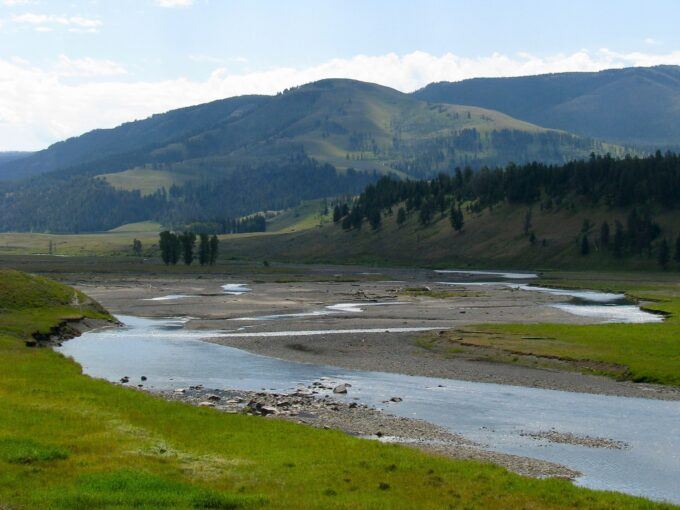
The State of Montana is Failing to Protect the Public’s Water and Fish
Lamar River, Yellowstone. Photo: Jeffrey St. Clair.
Anyone who drives around the state of Montana right now can see one unassailable truth: our state’ renowned rivers and the prized fish which inhabit them are in big trouble.From east to west, north to south our great rivers have withered to tiny ribbons of water, un-floatable for most recreation and uninhabitable for our native and prized trout species.
When rivers shrink, algae explodes and temperatures soar, as sunlight penetrates the water from top to bottom. As the algae decays, it consumes oxygen, turning what was a perfectly oxygenated, cold-water fish habitat into a hypoxic dead zone, where nothing can survive.
Anyone who has lived in Montana for more than a few seasons can tell: these symptoms are no longer rare events, happening every so often.Now, it seems, this is the new normal. Like many things in nature, the reason for our declining surface water supplies is multifaceted. Climate change is inducing drought, year over year, while demand for water soars as every inch of Montana is bought up and groundwater is given away for new development. Simultaneously, the state is allowing unlimited nutrient pollution through categorical exclusions from water quality protections.Where these political realities meet is at a dead river. Where they began is with Governor Gianforte’s Red Tape Initiative.
So what can the state of Montana do about it? We could start by enforcing the states’ public water rights, which have the exact legal purpose of protecting in-stream flows. That’s right – the state owns water rights and they are a part of the public trust, like our right of stream access. That means the state must protect those interests, above all else, or they violate our constitutional rights. Yet, in pursuit of its political pro-business agenda, the Gianforte administration is refusing to exercise these rights on our behalf.Instead, the very water that is supposed to be left in our rivers, is exploding out of private center pivots everywhere you look.
Since fish can’t sue, the Alliance for the Wild Rockies, Upper Missouri Waterkeeper and Save the Bull Trout are suing for the fish and also for people who recreate on our world class rivers. In Montana, like much of the West, water is property and that property is extremely valuable in our arid climate. Without question, ranchers have a right to use water but so to do the fish and the people of Montana.
The most valuable right the public owns is located where the Blackfoot River joins the Clark Fork River at the site of the former Milltown Dam.
The Montana Power Company was granted2000 cfs for its water right when the dam was built in 1904 as an instream hydropower right to generate electricity. In 2008, the State of Montana acquired this very senior water right through the Upper Clark Fork River Basin Superfund settlement with the intent that the water right would be used to restore the fishery and recreational uses. Yet, during the hottest and driest period on record, when the famed Blackfoot river has been in the 0% percentile of flows all summer, Montana Fish Wildlife and Parks and Governor Gianforte have not enforced our rights.
This is but one example of the tragedy that is unfolding.
Simply put, our lawsuit alleges that Montana Fish Wildlife and Parks has a duty to enforce and protect its water rights by making a call to support minimum flows designed to protect aquatic life because state held instream flow rights are part of the public trust and thus the agency is constitutionally mandated to utilize them to protect our right to a clean and healthy environment.
Afterall, there is nothing more antithetical to a clean and healthy environment than a dead, dry river.
Please consider joining us to protect our rivers that are world famous, not just for fishing but also for floating and swimming.
Mike Garrity is the executive director of the Alliance for the Wild Rockies.
Grand Canyon’s Dragon Bravo Megafire Shows the Growing Wildfire Threat to Water Systems
A National Park Service worker assesses a split in an exposed section of the Grand Canyon’s fragile water lines in 2014. The water pipeline, installed in the mid-1960s, feeds water from Roaring Springs, located approximately 3,500 feet below the North Rim. Grand Canyon National Park via Flickr
As wildfire crews battled the Dragon Bravo Fire on the Grand Canyon’s North Rim in July 2025, the air turned toxic.
A chlorine gas leak had erupted from the park’s water treatment facility as the building burned, forcing firefighters to pull back. The water treatment facility is part of a system that draws water from a fragile spring. It’s the only water source and system for the park facilities on both rims, including visitor lodging and park service housing.
The fire also damaged some of the area’s water pipes and equipment, leaving fire crews to rely on a fleet of large water trucks to haul in water and raising concerns about contamination risks to the water system itself.
By mid-August, Dragon Bravo was a “megafire,” having burned over 140,000 acres, and was one of the largest fires in Arizona history. It had destroyed more than 70 structures, including the iconic Grand Canyon Lodge, and sent smoke across the region.
Wildfires like this are increasingly affecting water supplies across the U.S. and creating a compounding crisis that experts in water, utilities and emergency management are only beginning to wrestle with.
A pattern across the West
Before 2017, when the Tubbs Fire burned through neighborhoods on the edge of Santa Rosa, California, most research on the nexus of wildfire and water had focused on issues such as drought and how climate change effects ecosystems.
The Tubbs Fire destroyed thousands of buildings and also melted plastic water pipes. After the fire, a resident’s complaint about the taste and odor of tap water led to the discovery that the fire’s damage had introduced contaminants including benzene, a carcinogen, into parts of the public water system.
It quickly became obvious that the damage discovered at the Tubbs Fire was not unique.
In southern Oregon, the 2020 Almeda Fire damaged water pipes in buildings, leaving water to flow freely. That contributed to low system pressure just when people fighting the fire needed the water.
Water meters and pipes are vulnerable to damage during a fire. Andrew Whelton/Purdue University, CC BY
In Colorado, the 2021 Marshall Fire burned through urban water lines, damaging six public drinking-water systems along with more than 1,000 structures in the Boulder suburbs. All six systems lost power, which in some cases led to a loss of water pressure, hampering firefighting.
As firefighters worked on the Marshall Fire, water system operators raced to keep water flowing and contaminants from being transported into the water systems. But tests still detected chemical contamination, including benzene, in parts of the systems a few weeks later.
Then, in January 2025, the Los Angeles fires supercharged concerns about water and wildfire. As firefighters raced to put out multiple fires, hydrants ran dry in some parts of the region, while others at higher elevations depressurized. Ultimately, over 16,000 structures were damaged, leading to insured losses estimated to be as high as US$45 billion.
Water infrastructure is not merely collateral damage during wildfires – it is now a central concern.
It also raises the question: What can residents, first responders and decision-makers reasonably expect from water systems that weren’t designed with today’s disasters in mind?
Addressing the growing fire and water challenge
While no two water systems or fires are the same, nearly every water system component, ranging from storage tanks to pipelines to treatment plants, is susceptible to damage.
The Grand Canyon’s Roaring Springs system exemplifies the complexity and fragility of older systems. It supplies water to both rims of the park through a decades-old network of gravity-fed pipes and tunnels and includes the water treatment facility where firefighters were forced to retreat because of the chlorine leak.
Many water systems have vulnerable points within or near flammable wildlands, such as exposed pump houses that are crucial for pulling water from lower elevations to where it is needed.
In addition, hazardous materials such as chlorine or ammonia may be stored on-site and require special considerations in high fire risk areas. Staff capacity is often limited; some small utilities depend on a single operator, and budgets may be too constrained to modernize aging infrastructure or implement fire mitigation measures.
As climate change intensifies wildfire seasons, these vulnerabilities can become disaster risks that require making water infrastructure a more integral part of fighting and preparing for wildfires.
+ Prioritizing fire-resistant construction, better shielding of chemicals and, in some cases, decentralizing water systems can help protect critical facilities, particularly in high-risk zones. Having backup power supplies, mobile treatment systems and alternate water sources are essential to provide more security in the face of a wildfire.
+ Emergency command protocols and interagency coordination are most effective when they include water utilities as essential partners in all phases of emergency response, from planning to response to recovery. Fire crews and water operators can also benefit from joint training in emergency response, especially when system failure could hinder firefighting itself.
+ Longer term, protecting upstream watersheds from severe fire by thinning forests and using controlled burns, along with erosion control measures, can help maintain water quality and reduce water pollution in the aftermath of fires.
+ Smaller and more isolated systems, particularly in tribal or low-income communities, often need assistance to plan or implement new measures. These systems may require technical assistance, and regional support hubs could support communities with additional resources, including personnel and equipment, so they can respond quickly when crises strike.
Looking ahead
The Dragon Bravo Fire isn’t just a wildfire story, it’s also a water story, and it signals a larger, emerging challenge across the West. As fire seasons expand in size and complexity, the overlap between fire and water will only grow.
The Grand Canyon fire offers a stark illustration of how wildfire can escalate into a multifaceted infrastructure crisis: Fire can damage water infrastructure, which in turn limits firefighting capabilities and stresses water supplies.
The question is not whether this will happen again. It’s how prepared communities will be when it does.