Global Warming Icon “Doomsday Glacier” in Trouble
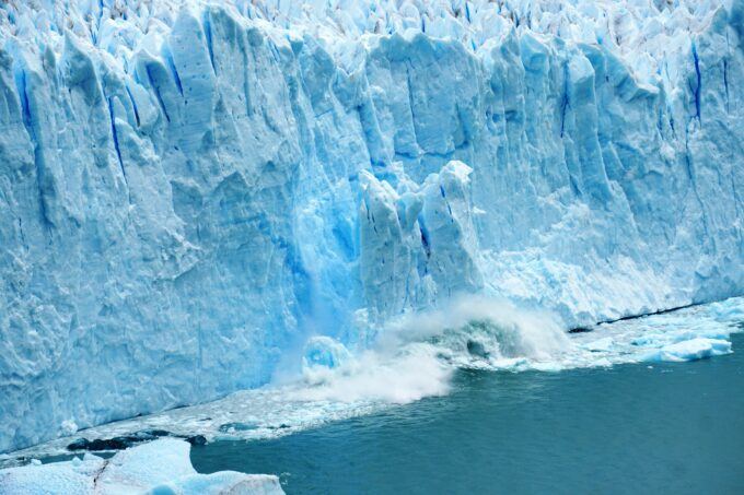
Image by Dominik Van Opdenbosch.
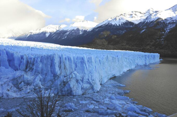
Thwaites “the Doomsday Glacier” West Antarctica is the world’s most famous icon of global warming. It is acting up!
Recent satellite images show a massive breakup in-process, to wit: “It’s dramatic. I was there in 2019/2020 and when I look at the satellite images now, I don’t recognize the shelf. There are huge gashes where there used to be none,” says Karen Alley at the University of Manitoba in Canada, who has been analyzing how this break-up is playing out.” (The ‘Doomsday’ Glacier’s Giant Ice Shelf is About to Break Away, New Scientist, May 18, 2026)
If global warming needs a symbol for progress to a hotter planet, the Thwaites Doomsday Glacier coming apart while nestled within the coldest continent on Earth is evidence of resounding success. Yes, human-generated CO2 global warming is overtaking and powerfully altering the coldest spot on Earth. It is breathtaking and should rattle the bones of anybody questioning the dangers of climate change. After all, it’s cracking apart the ice shelf of a 75-mile-wide behemoth. It’s met its match in the 21st century for the first time in a few million years.
Meanwhile, Trump’s proposed budget and administrative directives have significantly reduced U.S. polar science funding. The cuts target the National Science Foundation (NSF) by proposing reductions slashing up to 70% of polar research funding and terminating the lease on America’s only Antarctic research icebreaker the Nathaniel B. Palmer, so polar scientists can’t go there.
The administration doesn’t want Americans exposed to the impact of global warming. It’s far too depressing for the public to handle. It’s much better if they are kept in the dark, unknowing, whilst spending tons of money, on credit cards, on goods and services, without a worry. But at what point in time will the residents of Miami Beach feel compelled (“scared”) enough to hit the streets with placards: “Refund Polar Science Now!” The “need to know” is paramount.
The Monster
Antarctica contains thousands of individual glaciers. The continent is dominated by three massive ice sheets: East Antarctic, West Antarctic, and Antarctic Peninsula combined as large as Mexico and the U.S. together.
Thwaites is a monster glacier and a trigger mechanism for the entire West Antarctic Ice Sheet (“WAIS”) containing 10 feet of sea level frozen solid in ice. However, removing Thwaites’ Ice Shelf is like removing the goalie late in a hockey game, leaving the net wide open. WAIS is free to flow faster than ever before to the sea.
Thwaites is the world’s widest glacier at 75 miles width. It is 1,000-to-3,500 feet deep. It is currently a stabilizing buttress for the entire West Antarctic Ice Sheet but starting to lose stability in a big noticeable way!
According to the New Scientist article: “Antarctica’s most threatened glacier is about to be further destabilized, as the floating ice shelf in front of Thwaites glacier is set to break away… its collapse is expected to set off a domino effect in the entire West Antarctic ice sheet, ultimately resulting in a calamitous sea-level rise of 3.3 metres and changing the coastline of the entire planet.”
Although, the timing of this is unknown. There are polar scientists who claim 13’ feet of sea level rise by 2100 (if so, how much by 2030-40, Ouch!) Gino Casassa, a glaciologist and head of Chilean Antarctic Institute, said that current estimates show sea levels rising by 4 meters by 2100 and more if emissions continue to grow with current generations. Other climate scientists claim only one-to-two feet, not thirteen, take your pick. Frankly, nobody knows, but what is known is that Thwaites is well ahead of where anybody thought it would be only a few years ago, to wit: “Huge fractures are opening up around the pinning point – where the ice shelf’s floating front is held in place by a raised ridge on the ocean floor – and along the grounding line, the point where the glacier meets the ocean and starts to float,” Ibid.
And even more concerning: “The ice shelf’s demise is also signaled by a dramatic speed-up in its flow rate. ‘It’s tripled from January 2020 to January 2026, to just over 2000 metres per year, which is nuts,’ says Christian Wild at the University of Innsbruck in Austria. And in the past five months, the flow has accelerated further. ‘It’s essentially in free fall now,” Ibid.
According to Richard Alley, Professor of Geosciences at Penn State: “Ice shelves are only really stable when it’s quite cold… The ocean has to be cold and the atmosphere has to be cold. But we’re warming the world and we’re losing the ice shelves, and that’s exactly what you’d expect,” Ibid.’
Global Warming Clobbers Antarctica
Antarctica has been experiencing record-breaking, massive temperature spikes and unprecedented deep ocean heating. In recent winters, parts of the continent have seen temperatures soar between 15°C to 40°C (72°F) above normal. During the Southern Hemisphere’s winter, regions of East Antarctica recorded temperatures spiking more than 40°C (72°F) above average driven by a distorted polar vortex and “atmospheric rivers” carrying warm, moist air deep into the continent’s interior.” Additionally, research published in Communications Earth & Environment shows heat trapped deep in the Southern Ocean rising and melting sea ice and glaciers from below.
“Since 2015, Antarctic sea ice has declined sharply. In 2023, winter sea ice extent fell to record lows – so far below the long-term average that scientists considered it an event with roughly a one-in-3.5 million probability of occurring by chance… Antarctica was long considered a part of the climate system expected to change slowly. The speed of the recent sea ice decline has therefore come as a shock. In our new scientific study: Compound Drivers of Antarctic Sea Ice Loss and Southern Ocean Destratification, Science Advances, Vol 12, Issue 19, May 8, 2026, we show that the ocean around Antarctica has undergone a fundamental shift. Heat that had been trapped deep below the surface is rising upwards, where it can melt sea ice.”
The Doomsday Glacier is living up to its billing, and it’s happening faster than climate models predicted. One can only hope that sea level rise will not also beat predictions. It is the wild card of all wild cards with enough mass to spook the world. Meanwhile it cannot be overlooked that U.S. policies have sided with fossil fuels, instead of renewables, which emit the greenhouse gases that heat up the planet that directly impacts and collapses Antarctica. They are on the wrong side of history. The rapidly deteriorating Thwaites Glacier is proof positive,