Researchers create global arsenic-in-groundwater maps to highlight threats
by Bob Yirka , Phys.org

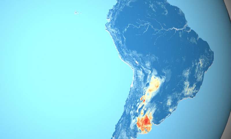
Modeled probability of arsenic concentration in groundwater exceeding 10 µg per liter (red: high probability, blue: low probability). Credit: Joel Podgorski, Michael Berg, Eawag
A pair of researchers at the Swiss Federal Institute of Aquatic Science and Technology has created a global map that highlights areas where there are likely dangerous levels of arsenic in groundwater. In their paper published in the journal Science, Joel Podgorski and Michael Berg describe combining data from a variety of sources to train a machine learning algorithm to highlight possible hot spots on a global map. Yan Zheng, with Southern University of Science and Technology has published a Perspective piece outlining the work by the research pair in the same journal issue.
The current pandemic has captured the attention of the world, and for good reason. But other threats continue to put millions of people at risk. One of these, as Zheng notes, is arsenic consumption. Commonly known as a type of poison used to kill rivals, arsenic is a metalloid that, when consumed, can cause serious medical problems and, of course, death. It is also a chemical element that is commonly found in soil and rocks. In some cases, conditions exist that allow arsenic to make its way into groundwater, where it can be pulled up and consumed, putting people at risk.
Scientists have been aware of the problem of arsenic poisoning groundwater in such places as Argentina, Bangladesh and Vietnam. The WHO is also aware of the problem—they have set a concentration of 10 micrograms per liter as a safety limit in consumable water. In this new effort, Podgorski and Berg, an environmental scientist and hydrologist respectively, suspected that there are likely more hotspots than are currently known, so they set themselves the task of revealing likely hotspots around the world by analyzing vast amounts of data.
Play
Modeled probability of arsenic concentration in groundwater exceeding 10 µg per liter (red: high probability, blue: low probability). Credit: Joel Podgorski, Michael Berg, Eawag
The work involved assembling data from over 80 studies and then using a machine learning algorithm that processed the data and made estimates on the likelihood of arsenic levels in groundwater for 1-km2-patches covering the entire globe. They then used the predictions to create a map showing arsenic threat levels. The map showed that up to 220 million people around the globe may be at risk of drinking water contaminated with dangerous levels of arsenic.
The work involved assembling data from over 80 studies and then using a machine learning algorithm that processed the data and made estimates on the likelihood of arsenic levels in groundwater for 1-km2-patches covering the entire globe. They then used the predictions to create a map showing arsenic threat levels. The map showed that up to 220 million people around the globe may be at risk of drinking water contaminated with dangerous levels of arsenic.
Play
https://phys.org/news/2020-05-global-arsenic-in-groundwater-highlight-threats.html
Modeled probability of arsenic concentration in groundwater exceeding 10 µg per liter (red: high probability, blue: low probability). Credit: Joel Podgorski, Michael Berg, Eawag
More information: Joel Podgorski et al. Global threat of arsenic in groundwater, Science (2020). DOI: 10.1126/science.aba1510
No comments:
Post a Comment