for a hurricane to make direct landfall on Grenada on the first day of July is completely unprecedented."
By Anna Skinner
Senior Writer, General Assignment
Published Jul 01, 2024
Published Jul 01, 2024
Satellites produced a "sobering" image of Beryl as it made landfall Monday in the Windward Islands as a Category 4 hurricane.
Beryl strengthened into a hurricane on Saturday, becoming June's easternmost major hurricane in the Atlantic. The storm underwent rapid intensification, and it became a Category 4 hurricane as soon as its wind speeds reached 130 miles per hour. Beryl temporarily weakened to a Category 3 before strengthening again, with maximum winds documented at 150 miles per hour when it made landfall.
"Sobering satellite imagery of high-end Category 4 Hurricane #Beryl with max winds of 150 mph making landfall on Carriacou Island (Grenada)," extreme storm chaser Colin McCarthy posted on X (formerly Twitter).
He went on: "Beryl is the strongest Caribbean hurricane ever recorded this early in the season and [it's] making landfall at peak intensity. Only one other Category 4-5 hurricane on record since 1850 has moved within 75 miles of Grenada: Ivan in September 2004. However, for a hurricane to make direct landfall on Grenada on the first day of July is completely unprecedented."
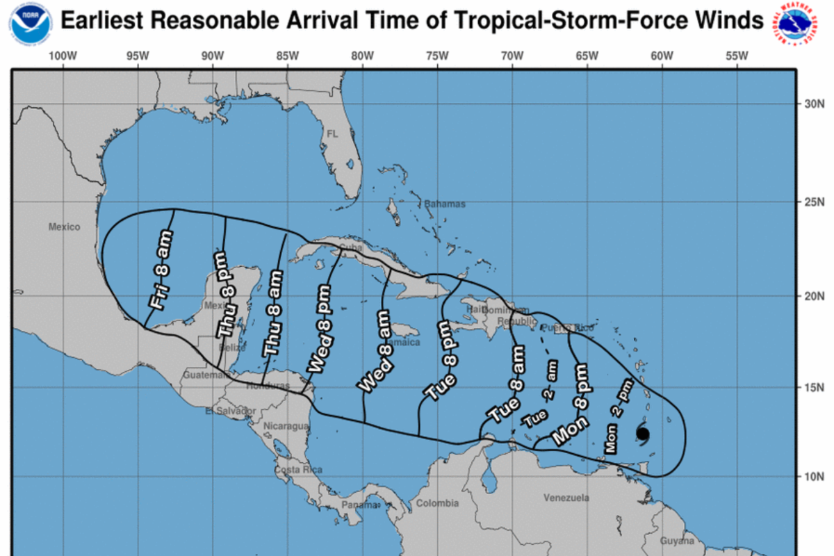
A map from the National Hurricane Center shows the arrival time of winds associated with Hurricane Beryl. NATIONAL HURRICANE CENTER
The satellite video McCarthy included with his post shows Beryl swirling over the Caribbean before it tears through Grenada, one of the Windward Islands.
The satellite video McCarthy included with his post shows Beryl swirling over the Caribbean before it tears through Grenada, one of the Windward Islands.
National Hurricane Center (NHC) senior hurricane specialist John Cangialosi told Newsweek that satellite imagery is a forecaster's "eyes" when it comes to hurricanes.
"That's what gives us so much information about where the center is located, its structure to some degree, its strength," he said. "It helps us understand how the storm is changing over time."
Cangialosi added that satellite imagery is NHC's No. 1 data point.
The NHC has published numerous updates warning residents of the "extremely dangerous and life-threatening situation." As of 11 a.m. Atlantic Standard Time, Beryl's eyewall, a ring of thunderstorms that produce heavy rains and typically the strongest winds, was moving through the southern Windward Islands.
"Residents in Grenada, the Grenadine Islands, and Carriacou Island should not leave their shelter as destructive winds and life-threatening storm surge are expected during the next few hours," the NHC said.
In addition to the winds and storm surge, Beryl produced heavy rainfall and localized flash flooding.
"Beryl is expected to remain a powerful hurricane as it moves across the Caribbean Sea later this week," the NHC said. "A Hurricane Watch has been issued for Jamaica. Interests in the Cayman Islands, Belize, the Yucatan Peninsula, and the remainder of the northwestern Caribbean should monitor its progress."
Beryl is the first hurricane of the 2024 Atlantic hurricane season and the second named storm. Tropical Storm Alberto made landfall in Mexico on the morning of June 20. Shortly after Beryl formed, the third named storm of the season—Tropical Storm Chris—formed quickly on Sunday night. Chris made landfall in Mexico on Sunday night, with wind speeds at around 40 mph. It has since dissolved.
The NHC is tracking another tropical disturbance, in the central tropical Atlantic, that has a 20 percent chance of forming in the next 48 hours.
No comments:
Post a Comment