Tuesday, June 28, 2022

Flood exposure and poverty in 188 countries

Absract

Flooding is among the most prevalent natural hazards, with particularly disastrous impacts in low-income countries. This study presents global estimates of the number of people exposed to high flood risks in interaction with poverty. It finds that 1.81 billion people (23% of world population) are directly exposed to 1-in-100-year floods. Of these, 1.24 billion are located in South and East Asia, where China (395 million) and India (390 million) account for over one-third of global exposure. Low- and middle-income countries are home to 89% of the world’s flood-exposed people. Of the 170 million facing high flood risk and extreme poverty (living on under $1.90 per day), 44% are in Sub-Saharan Africa. Over 780 million of those living on under $5.50 per day face high flood risk. Using state-of-the-art poverty and flood data, our findings highlight the scale and priority regions for flood mitigation measures to support resilient development.

Introduction

Globally, natural shocks are estimated to cause an average of over $300 billion in direct asset losses every year; this estimate increases to $520 billion when considering well-being (or consumption) losses1. While each country faces its individual set of natural hazards, including cyclones, earthquakes, or wildfires, floods are among the leading threats to people’s livelihoods and affect development prospects worldwide2. Especially in lower-income countries—where infrastructure systems, including drainage and flood protection, tend to be less developed—floods often cause unmitigated damage and suffering3. Recent disastrous floods in countries as diverse as Nigeria, Bangladesh, Vietnam, the United States, and the United Kingdom illustrate that the threat is a global reality. Rare, major floods and smaller, frequent events alike can revert years of progress in development4 and poverty reduction. Understanding the scale and distribution of risks is crucial for devising targeted mitigation measures and allocating adequate resources.

While the threat is already substantial, several ongoing trends could result in significant increases in flood risks in coming years. For a high-concentration climate change scenario, estimates from 11 climate models converge to the conclusion that flood frequencies in Southeast Asia, East and Central Africa, and large parts of Latin America could increase substantially by 21005. Even in an optimistic climate change scenario (RCP 2.6), sea levels are estimated to rise up to 0.55 m by 2100, putting especially large coastal cities at risk6. Land subsidence, often caused by unsustainable ground water extraction and drainage, has been shown to increase coastal flood risks at a rate four times faster than sea level rise7.

Flood risks are also driven by socioeconomic change, as the number of people, assets, and value of economic activities increase over time3. By one estimate, in the absence of risk-mitigating measures, socioeconomic growth could result in the absolute damages from flooding to increase by a factor 20 by 2100. Considering the compounded effect of these drivers in the world’s 136 largest coastal cities, one study has shown that population and asset growth, climate change, and subsidence are likely to contribute to a drastic increase in global average flood losses, from $6 billion per year in 2005 to over $60 billion in 20508.

Recognizing the severe impacts of disasters on socioeconomic development, many flood exposure assessments have been conducted at local and national scales, often leveraging the recent availability of high-resolution flood, asset, and population maps, enabling increasingly accurate risk assessments. Yet, local studies have focused predominately on high-income countries like the European Union, United States, and Japan, not least due to data availability and the large economic values at risk9,10. While studies exist for developing countries, attention is focused on large economic centers like Jakarta, Dhaka, Dar es Salaam, Accra, and Ho Chi Minh City11,12,13,14,15,16; few systematic assessments exist for the least developed countries and subregions, where floods are likely to have the most devastating impacts on livelihoods.

Overall, there is limited evidence on the global scale of flood exposure and how it relates to the incidence of poverty. Previous global flood risk assessments suffer from multiple limitations. By using global historical inventories of recorded flood events (e.g., from EM-DAT), studies have estimated exposure indicators at the country level17. Yet, the lack of data on the spatial distribution and coincidence of flood risk and populations means that this approach does not allow a robust estimation of exposure headcounts17,18. A more recent study documents the worrying trend of increasing flood exposure using satellite data for 2000 to 2018, though omits at-risk populations who remained unaffected during the study period and many events that remain undetected by the satellite observations19.

Studies that use relatively coarse (by current standards) spatial resolution flood hazard data tend to only represent major fluvial floodplains. This means they are unable to capture pluvial flood risk and flooding along secondary rivers, and thus drastically underestimate exposure3,5,20,21. One study projects that the global number of flood-exposed people will reach 1.3 billion by 205020, but our study shows that this threshold has already been exceeded by at least 39%. This illustrates the importance of high-resolution data to capture the highly localized nature of flood risks, and the tendency of people to avoid settling in the riskiest locations22. Other global studies have only focused on certain types of flood, rather than assessing the combined risks from fluvial floods (rivers exceeding their capacity due to excessive precipitation), pluvial floods (surface water build-up due to extended precipitation and insufficient drainage), and coastal floods (due to tidal or storm surges, or sea level rise)2,23,24,25,26,27. For instance, a recent study conducted a detailed global assessment of the risk of sea level rise to the world’s coastal population28, estimating that over 190 million people live in areas that could be inundated by sea level rise by 2100; but it does not consider inland flood risks. Other studies have only assessed risks for a subset of countries, falling short of full global coverage22. Most importantly, none of the existing global studies consider the intersection between flood exposure and poverty incidence, which is a crucial indicator for people’s vulnerability, resilience, and ability to cope with and recover from floods1. This study addresses these gaps.

We find that about 1.81 billion people, or 23% of the world population, are directly exposed to inundation depths of over 0.15 meters. This would pose significant risks to lives and livelihoods, especially of vulnerable population groups. The majority (1.24 billion) are located in South and East Asia, where China (395 million) and India (390 million) account for over one-third of global exposure. Low- and middle-income countries are home to 89% of the world’s flood-exposed people. Of the 170 million who face high flood risk and extreme poverty (living under $1.90 per day), 44% are in Sub-Saharan Africa. At least 780 million people face high flood risk, while living on less than $5.5 per day. We conclude that the number of people living in poverty and under severe flood risk is substantially higher than previously thought. Moreover, they are concentrated in vulnerable regions that face compounding risks from climate change, sociopolitical instability, and resource constraints that hamper effective risk management. By offering global, yet disaggregated, insights on flood risk exposure and poverty incidence, this study highlights the scale of the needs and priority regions for flood risk mitigation measures that can safeguard livelihoods and prevent prolonged adverse impacts on development.

Results

Here we present results from a high-resolution global exposure assessment for 188 countries, reaching within rounding errors of the entire world population. We assess people’s exposure to all current flood risks—that is, pluvial, fluvial, and coastal flooding. Flood data from Fathom-Global 2.0 are based on latest generation terrain and hydrographic models, while population density uses WorldPop 2020 maps calibrated on census and satellite data (Fig. 1). The global coverage of these datasets enables an overlay analysis with 3 arcseconds resolution (equivalent to about 90 × 90 meters at the equator), providing a more granular assessment than previous studies and eliminating the need for analytical assumptions besides the ones employed for producing the datasets. In addition, we use the latest edition of the World Bank’s Global Subnational Atlas of Poverty (GSAP), which harmonizes household survey data and offers poverty estimates with global coverage and statistical representativeness at the subnational level. Full technical details on data and computational process are provided in the “Methods” section.

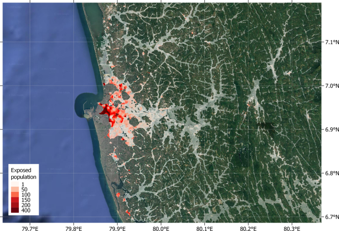
Fig. 1: Flood exposed populations in the metropolitan region of Colombo, Sri Lanka.
figure 1

Highlighted areas correspond to populated locations with significant flood risk as identified in this study. White highlights correspond to low population density, while red highlights show densely populated areas. Legend numbers denote number of flood exposed people per 3 arcsecond pixel. (Image: Google, ©2022 TerraMetrics).

Global and regional flood exposure

Our estimates show that globally, 1.81 billion people (23% of the world population) live in locations that are exposed to a significant level of flood risk, facing inundation depths greater than 0.15 meters in the event of a 1-in-100-year flood, or at least medium risk (Fig. 1). In other words, considering a global population of 7.9 billion29, almost one in four of the world’s people are exposed to significant flood risk.

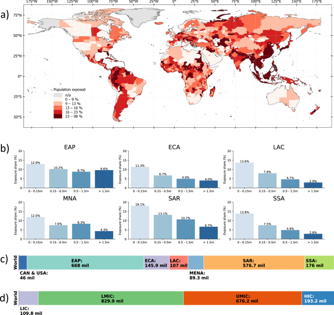
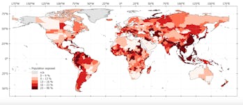
Regionally disaggregating global exposure headcounts, it becomes apparent that flood risks are particularly prevalent in certain regions. At 668 million people, the East Asia and Pacific region has the highest number of people exposed to significant flood risk, corresponding to about 28% of its total population. In the South Asia region, 576 million people are exposed to significant flood risk (about 30.4% of the population). Between 9–20% of the regional populations of Sub-Saharan Africa, Europe and Central Asia, Middle East and North Africa, Latin America and the Caribbean, and the United States and Canada are exposed to high flood risk. Figure 2 provides a full breakdown of regional exposure estimates in absolute and relative terms. In East Asia and Pacific, South Asia, and the Middle East and North Africa, regional exposure is driven by single countries, namely China, India, and Egypt.

Fig. 2: Population exposed to floods.
figure 2

a shows the percentage of population exposed to at least medium-level flood risk at the subnational level. b displays the percentage of population exposed to different levels of flood risk in each region. cd show the total number of people exposed to at least medium-level flood risk based on geographical region and countries’ income classification, respectively. EAP East Asia and Pacific, ECA Europe and Central Asia (ECA), SAR South Asia region, SSA Sub-Saharan Africa, MNA Middle East and North Africa, LAC Latin America and the Caribbean, CAN & USA United States and Canada, HIC high-income countries, UMIC upper middle-income countries, LMIC lower-middle-income countries, LIC low-income countries.

Our results also show that 1.61 billion (89%) of the world’s flood-exposed people live in low- and middle-income countries and about 193 million (11%) live in high-income countries (Fig. 2d). Considering that flood-exposed populations in high-income countries are more likely to benefit from flood protection systems, social postdisaster assistance, and other risk management support, these figures highlight the significant risks faced by developing countries. Full country-level results are provided in Supplementary Table 1.

Countries with the largest flood-exposed populations

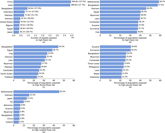
Several countries stand out with particularly large populations directly exposed to high flood risk (Fig. 3a); and several factors explain this picture. Evidently, more populous countries are more likely to have large numbers of people living in direct exposure to flood risk. The two most populous countries, India and China, have the highest absolute exposure headcounts with 390 million and 395 million, respectively, and account for about one-third of all people exposed to flood risk globally. Yet, geographical features and urbanization patterns can drastically increase the size of exposed populations. The top 10 countries in terms of absolute exposure headcounts feature countries in which large population groups are concentrated along major river systems (e.g., Bangladesh, Egypt, Vietnam) or in coastal regions (e.g., Indonesia, Japan).

Fig. 3: Absolute and relative population exposure at country level.
figure 3

a shows the ten countries with highest absolute number of people exposed (and as a percentage of the total population in parentheses). b shows the ten countries with highest relative population exposure. ce show the ten countries with highest relative population exposure to different kinds of flood risks. Note: Countries or territories with populations of under 100,000 are omitted from this figure, in particular Andorra (24.3%, d) and Cayman Islands (6%, e).

However, focusing on absolute exposure headcounts risks overlooking countries with smaller populations yet large relative exposure. Figure 3b presents the top 10 countries in terms of percentage of population exposed to high flood risk, in all of which over one-third of the population is flood-exposed. The Netherlands has the world’s highest relative exposure to flood risk, with 58.7% of the population living in areas that would face inundation depths of over 15 cm in the event of a 1-in-100-year flood without considering flood protection systems. The country has some of the world’s most comprehensive flood protection systems, with protection against extreme events of up to 1-in-10,000-year return periods that can effectively mitigate the risks estimated in this study.

The same is not true, however, for most other countries with high exposure, particularly low- and middle-income countries, where flood risks coincide with poverty and vulnerability. Vietnam, where 46% of the population is located in flood zones, is a leader among developing countries in its efforts to mitigate natural risks. Its extensive sea dike system stretches over 2600 kilometers, exceeding many other countries’ protective infrastructure14. Yet the system is built to safety standards that only protect against 1-in-30-year coastal flooding, and would be overwhelmed by more severe events14.

Geographic and urbanization patterns are driving the high flood exposure relative to countries’ population size. Considering exposure to different flood types highlights these factors (Fig. 3c–e). Fluvial flood risks dominate in areas where large population shares are concentrated in low-lying river basins, such as the Brahmaputra (Bangladesh), Euphrates and Tigris (Iraq), Irrawaddy (Myanmar), Indus (Pakistan), Mekong (Cambodia, Laos, Vietnam), and Nile (Egypt, South Sudan). Pluvial flooding drives risks in mountainous regions where natural drainage capacity is more limited and flash flood risks are heightened (e.g., Nepal, Andorra), or in climates with intense rainy seasons that exceed drainage and soil absorption capacity (e.g., Bangladesh, Guyana, Myanmar, Suriname). Coastal flooding dominates in countries with expansive coastal urbanization (e.g., Guyana, Vietnam) and islands countries (e.g., The Bahamas, Fiji).

Flood exposure at subnational level

A spatially disaggregated view of flood exposure estimates highlights that, within countries, risks are concentrated in specific areas, such as the coast or river basins. Several subnational regions stand out with large, exposed populations (Fig. 4a). In the Indian states of Bihar, Uttar Pradesh, West Bengal—all located along the Ganges River—a combined 196 million people live in high-risk flood zones, accounting for 33–53% of the states’ respective populations. In Pakistan, ~48 million of Punjab’s 120 million people live in high-risk flood zones, corresponding to 38% of the province’s total population. Located at the confluence of the Ganges and Brahmaputra Rivers, almost two-thirds of the population of Bangladesh’s Dhaka Division are directly flood-exposed. In China, exposed populations are largest in provinces along the coast and Yellow River Valley.

Fig. 4: Absolute and relative population exposure at subnational level.
figure 4

a shows the ten subnational administrative areas with highest absolute number of people exposed (and as a percentage of the total population in parentheses). b shows the ten ADM-1 areas with highest relative population exposure.

While these are all large subnational regions that often exceed the size of smaller countries, our results show that in smaller subnational areas, much larger population shares can be at risk (Fig. 4b). The world’s top 10 subnational areas in terms of relative exposure are all in Africa and Asia. Pool Department in the Republic of Congo is located along the Congo River, and we estimate that 91% of its population of 360,000 faces significant flood risk. The subnational areas with highest relative exposure in Africa are Chad’s capital region N’djamena, on the Chari River, and South Sudan’s Unity State, on the White Nile. In three Thai provinces, all located along the flood-prone Chao Phraya River, 70–80% of the population are at direct risk. With about 85% of their population living in flood zones, Vietnam’s Red River Delta provinces have some of the world’s highest exposure rates, and are the country’s main population and economic centers.

Economic risk, poverty, and flood exposure

Using the World Bank’s global collection of harmonized household survey data, this study is able to highlight two seemingly contrasting findings: monetary flood exposure emphasizes risks in high-income countries; yet the interaction of flood exposure and poverty emphasizes risk in low-income countries. In short, by relying solely on monetary risk estimates, planners would bias their attention toward areas with high-value assets and large resources. But in so doing, they risk overlooking areas with high socioeconomic vulnerability, where flood risk mitigation measures are most urgently needed to protect lives and livelihoods.

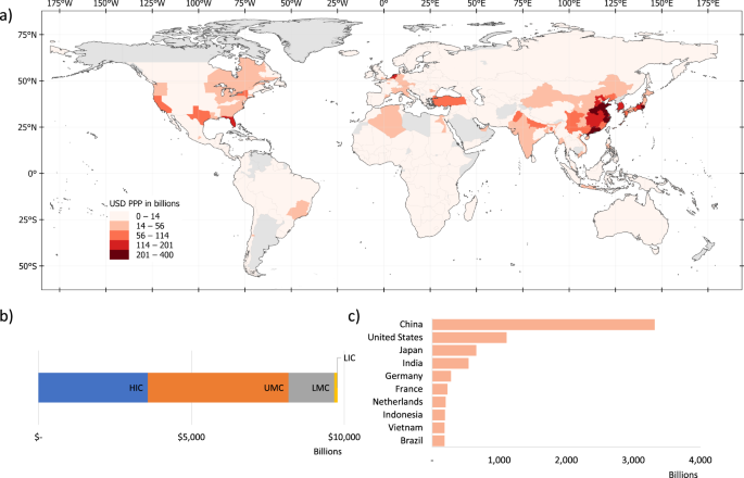
By combining the headcount estimates with per capita income levels, we translate flood exposure headcounts into estimates of the economic activity value that is directly exposed to flood risk. This monetary risk estimate suggests that $9.8 trillion of economic activity is directly located in areas with significant flood risks (note that this refers to exposed, not lost, economic activity, and does not distinguish people’s place of residence and work). This is equivalent to about 12% of global gross domestic product (GDP) in 202030. As Fig. 5 illustrates, monetary risk estimates highlight risks in higher-income countries, with the highest economic exposure in North America, Europe and East Asia, and Sub-Saharan Africa classified as having “low exposure” in monetary terms.

Fig. 5: Economic activity at risk, estimated by exposure headcounts multiplied by subnational income per capita.
figure 5

a shows the economic value at risk at an ADM-1 level. b displays the total economic value at risk for each region. c lists the top 10 countries with the highest economic value at risk. HIC high-income countries, UMIC upper middle-income countries, LMIC lower-middle-income countries, LIC low-income countries.

Of the $9.8 trillion of economic activity in flood risk areas, 84% is located in high- and upper middle-income countries (following the World Bank’s income classification). High-income countries account for 37% of exposed economic activity, but only 11% of the world’s flood-exposed population. In contrast, low- and lower-middle-income countries account for 52% of exposed people, but only 16% of exposed economic activity. Among countries with the largest economic value at risk, China leads, with $3.3 trillion exposed, followed by the USA ($1.1 trillion) and Japan ($0.7 trillion); no low-income country is among the top 10 countries in terms of economic value at risk. In interpreting these results, it is important to note that flood risk exposure does not account for existing flood protection measures. Such measures tend to be better developed in high-income countries, meaning that the fraction of exposed economic activity lost during a flood tends to be higher in low-income countries1.

Floods have been documented to cause more long-lasting and devastating effects in low-income communities. Here, lower-quality buildings and assets mean damages are higher1; inadequate planning and drainage infrastructure exacerbate hazards; the lack of widespread formal banking means people cannot draw on liquid savings or affordable credit to cope and recover; social systems lack the resources and reach they need to support affected populations; and insurance markets are less developed. To understand where flood risks pose the largest threat to development outcomes, a systematic assessment of poverty rates is essential.

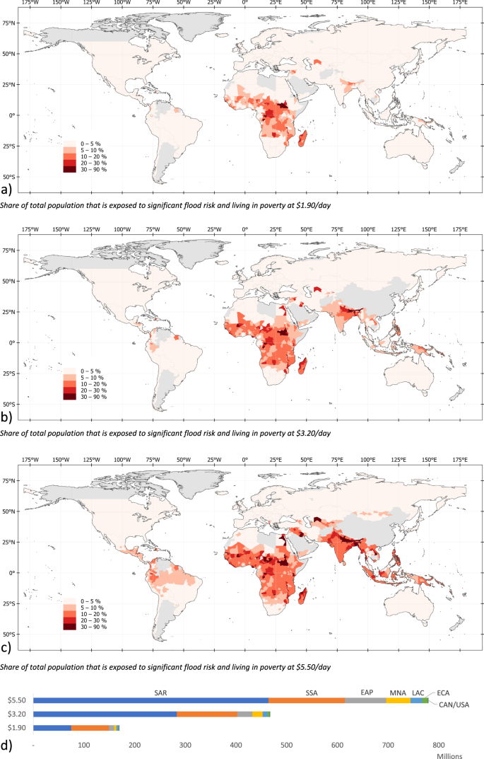
Our estimates show that of the 1.81 billion flood-exposed people globally, at least 170 million are living in extreme poverty (i.e., on less than $1.90 per day). Of these, 88% are located in Sub-Saharan Africa and South Asia (Fig. 6). Flood exposure coincides with poverty most widely in Sub-Saharan Africa, where 74.7 million people are both flood-exposed and living in extreme poverty; in South Asia, the figure is also 75.0 million, driven by India (66 million).

Fig. 6: Poverty and flood exposure.
figure 6

ac chart the share of total population exposed to significant flood risk and living with income below $1.90, $3.20, and $5.20 per day, respectively. d shows for each region the total number of people who are both exposed to significant flood risk and living in poverty. EAP East Asia and Pacific, ECA Europe and Central Asia, LAC Latin America and the Caribbean, MNA Middle East and North Africa, SAR South Asia region, SSA Sub-Saharan Africa.

The World Bank defines the $1.90 a day threshold as the most severe form of poverty, corresponding to a minimum subsistence level in low-income countries. However, floods are major livelihood shocks for all affected low-income households, even if they do not fall under the extreme $1.90 line. Hence, and given persistent poverty in middle-income countries, it is essential to consider less extreme poverty definitions. Indeed, when using less stringent poverty thresholds, the number of flood-exposed people in poverty increases significantly. We estimate that, globally, around 467 million people live in high-risk flood zones while living on less than $3.20 a day, increasing to 780 million if we consider incomes under $5.50 a day. This means that four out of every ten people exposed to flood risk globally are living in poverty (Table 1).

Table 1 Global flood exposure headcounts at different poverty thresholds for 2020.

The maps in Fig. 6 highlight that raising the poverty threshold shifts the geographic concentration of poverty and flood exposure from mainly Sub-Saharan Africa to include subnational regions in Egypt, the Middle East, South and East Asia, and Latin America. Increasing the poverty threshold from $1.90 to $5.50 doubles the number of people in Sub-Saharan Africa facing flood exposure and poverty from 75 million to 151 million. In SAR, the increase is sixfold, from 75 million to 464 million; in East Asia, it is eightfold, from 10 million to 81 million.

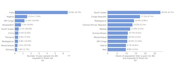
Among the top 10 countries where extreme poverty (at $1.90 threshold) and flood exposure coincide, seven are in Sub-Saharan Africa (Fig. 7a). With over 65 million, India has the highest number people exposed to flood risk and living in extreme poverty, though this represents only 16.8% of its total exposed population (390 million). As a share of the overall population, extreme poverty and flood exposure coincide most acutely in Sub-Saharan Africa (Fig. 7b); for these countries, 9–28% of the population faces significant flood risk while living in extreme poverty.

Fig. 7: Hotspots of coinciding poverty and flood exposure.
figure 7

Top 10 countries in terms of the number (a) and share (b) of people who are exposed to significant flood risk while living in extreme poverty (at $1.90/day).

Overall, these results highlight that flood risks are substantial in many low-income countries. Our results also show that the risks are often concentrated in subnational regions within these countries—for example, there are provinces in South Sudan and Congo where over 50% of the population is both flood exposed and living in extreme poverty. Despite being typically overlooked by monetary measures of flood risk, these countries and regions face substantial vulnerabilities due to poverty and associated challenges surrounding social safety nets and infrastructure quality.

CONTINUE READING

Flood exposure and poverty in 188 countries | Nature Communications
GLOBAL DISASTER
1.8 BILLION PEOPLE FACE ONCE-IN-A-CENTURY FLOODING, STUDY REVEALS


A shocking number of people globally are at risk of floods.
Getty

TARA YARLAGADDA

SOBERING IMAGES FROM NORTHEASTERN INDIA and Bangladesh this past month show the toll that historic flooding has caused the region. The extreme weather has killed more than 100 people and left 9.5 million more without food or drinking water.

But these 9.5 million individuals are only a fraction of the global population who are likely to face unprecedented flooding, according to research published Tuesday in the journal Nature Communications. The research reveals a disturbing figure: 1.81 billion people globally are “directly exposed” to one-in-a-hundred-year floods — a risk that will only worsen as global warming increases the likelihood of extreme flooding.

Thomas McDermott, a lecturer in the economics of climate change at the National University of Ireland Galway, tells Inverse the findings are “quite surprising — in fact shocking.” McDermott is not affiliated with the study but authored a Nature Communications article commenting on the research.

WHAT’S NEW — According to the study, 1.8 billion people, or 23 percent of the world’s population, live in areas exposed to a half-foot of water level rise during once-in-a-century flooding. It’s a figure far higher than previous research suggested.

“In other words, considering a global population of 7.9 billion, almost one in four of the world’s people are exposed to significant flood risk,” writes the study’s authors.

“One major surprise from this study is the vast scale of the risk. Flood risks are present in all 188 countries considered in this study,” Jun Rentschler, lead author of the study and Senior Economist at the Office of the Chief Economist for Sustainable Development at the World Bank, tells Inverse.

According to McDermott, the “once-in-a-hundred” phrase is a bit of a misnomer, since it really just refers to anyone living in an area where the risk of flooding is at least one percent in any given year. Still, that percentage shouldn’t be taken lightly. Rentschler says that a 100-year flood has a 22 percent chance of occurring in a 25-year period and a 51 percent chance within 70 years.

“But it is more frequent than the term might suggest because probabilities add up over time,” Rentschler says.

According to the paper, the vast majority of people exposed to floods — 89 percent — live in low-and-middle-income countries, typically in South and East Asia and Africa. While 193 million people face flood risk in higher-income countries like the U.S., far more — some 1.61 billion people — live in lower-and-middle income countries.

“Poor people often lack the resources needed for a fast recovery, which means they can be at risk of devastating long-term impacts on their livelihoods,” Rentschler says.


A figure from the study shows the percentage of the population exposed to flood risk around the world. Rentschler et al

In terms of sheer numbers, 1.24 billion people experiencing flood risk live in South and East Asia. China and India alone account for a third of the global flood risk as 395 million people in China and 390 million in India are exposed to floods. Within countries, people living in certain regions, such as along major river tributaries, face greater flood risk. Roughly two-thirds of people living in the Dhaka region of Bangladesh are at risk of flooding due to their location at the intersection of the Ganges and Brahmaputra Rivers.

While researchers have previously studied flood risk in lower-and-middle income countries, this study uniquely links flood risk with poverty levels across more than 180 countries. The researchers calculate the percentage of people who face flood risk at three different levels of poverty: living under $1.90 per day, less than $3.20 per day, and under $5.50 per day.

“Poverty is a crucial indicator of people’s vulnerability to climate shocks, like floods,” Rentschler says.

A whopping 780 million people living on less than $5.50 per day are exposed to flood risk. Those living in Sub-Saharan Africa are particularly at risk. Of the 170 million people who face flood risk and live in extreme poverty of less than $1.90 per day, 44 percent live in Sub-Saharan Africa.

“We conclude that the number of people living in poverty and under severe flood risk is substantially higher than previously thought,” the study authors write.

HOW THEY DID IT — The scientists drew from population maps and census data, income data from the World Bank’s Global Subnational Atlas of Poverty, and high-quality flood hazard data from the Fathom Global dataset.

This combination of “new data sources” allowed the researchers to analyze flood risk and poverty at a level of “unprecedented” detail according to Rentschler.

The scientists analyzed all three types of flood risk: fluvial, pluvial, and coastal. This affects 7.9 billion people in 188 countries around the world. Fluvial flood risks occur in low-lying river regions while pluvial flooding occurs in mountainous regions with poor drainage systems and a high risk of flash floods.


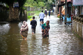
People wade through floodwaters in Companiganj, Bangladesh on June 26, 2022.
Getty

WHY IT MATTERS —People living in low-and-middle-income countries are most at risk of flooding, but the researchers are clear to emphasize that flooding can and does happen in nearly every nation. Only nine percent of subnational regions, or areas within countries, covered in the study face flood risks to less than one percent of their population. Roughly 12.5 percent of the U.S. population faces high flood risk according to supplementary data in the study.

“Recent disastrous floods in countries as diverse as Nigeria, Bangladesh, Vietnam, the United States, and the United Kingdom illustrate that the threat is a global reality,” conclude the researchers.

Flood risk exacts not only a human toll but also an economic one. According to the research, areas with “significant flood risks” are involved in $9.8 trillion worth of economic activity, which extreme flood events threaten to disrupt.

DIGGING INTO THE DETAILS — Higher-income countries often face significant financial losses from flooding, but they are often able to adapt to or lessen the damage from flooding in ways that poorer nations cannot. Focusing on flood exposure or economic losses alone doesn’t paint a “full picture” of true flood risk and risks biasing research toward higher-income nations, according to the research.

“The same flood event may be a mere inconvenience for wealthy people, but be absolutely devastating for poorer people,” Rentschler says.

For example, the country with the greatest flood risk exposure is the Netherlands. Nearly 60 percent of the country’s population lives in areas facing more than five inches of flooding, but the study says that the Dutch have the world’s most “comprehensive flood protection systems” that can protect against once-in-a-thousand-year extreme flood events.

On the other hand, a country like Vietnam may not have the means to adapt to climate change as successfully. Despite building dike systems across the country, Vietnam can still only “protect against 1-in-30-year coastal flooding, and would be overwhelmed by more severe events” according to the research.

The paper presents a remarkable overview of the global flood risks and how they intersect with poverty, but there’s still more data that needs to be gathered, experts suggest, especially on the flood risks facing poorer individuals within higher-income nations. McDermott says that “those on lower incomes tend to suffer worse consequences when disasters strike.”


A figure shows the intersection of poverty and flood risk. Rentschler et al

WHAT’S NEXT — The researchers have unveiled their findings, but it will be up to policymakers to translate the science into actionable measures to protect these 1.8 billion people around the world. Rentschler says “poor planning” such as the lack of drainage systems and development in high-risk areas increases the likelihood of flood damage.

“Conserving or restoring natural flood protection systems – such as wetlands and uninhabited flood plains — can be cost-effective solutions to reduce risks,” Rentschler says.

McDermott outlines three crucial paths forward for policymakers.

The first step: Curb greenhouse gas emissions, which are driving climate change and increasing the risk of severe flooding. We must take action on climate change “so that these risks do not get considerably worse in the coming decades,” McDermott says.

Second, the study’s findings imply that we need to invest more in disaster preparedness. This could involve investing in green infrastructure, emergency warning systems and flood defenses, as well as generally building up the capacity of communities to cope with disasters.

Finally, we should avoid building in areas where flood risk is highest, according to McDermott. The cost of not taking action is too high to consider.

“Flooding is by far the most pervasive climate hazard around the world, with floods displacing tens of millions of people from their homes each year, and causing hundreds of billions of US dollars in direct damages,” McDermott says.
DO NOT READ THIS WHILE EATING —
People are getting explosive gastroenteritis at the Grand Canyon

The outbreak is violently hollowing out visitors to the majestic canyon.

BETH MOLE - 6/28/2022
ARS TECHNICA

Enlarge / The Grand Canyon viewed from the South Rim adjacent to the El Tovar Hotel on November 11, 2019, in Grand Canyon National Park, Arizona.

The Grand Canyon is an immense, vibrantly painted geological wonder, treasured for its awe-inspiring stratified architecture, which has been spectacularly sculpted over millions of years. Up close, it will blow your mind and take your breath away—and if you've visited recently, it may also violently flush your colon and have you projectile vomiting your granola bars.

That's right—the majestic natural wonder has been the site of a months-long outbreak of gastrointestinal illness, likely caused by norovirus. The virus was confirmed to be the cause of illnesses among at least eight rafting trips. Overall, more than 150 river rafters and backcountry campers have fallen ill since April, according to a recent update from the Grand Canyon National Park Service.

While many may have sought the outdoor grandeur in hopes of avoiding the pandemic coronavirus, it seems they were instead met with a different germ that has been savagely hollowing out innards at a pace many orders of magnitude faster than the Colorado River gutted the southwestern section of the Colorado Plateau. Amid the smoothly carved buttes and intricately chiseled chasms serenely shaped over eons, park-goers are blowing chunks from both ends in hot seconds. And instead of reaching both the North and South Rims during their visits, some are forced to remain perched on the edge of a far smaller basin.

It's unclear how exactly the illness is spreading among visitors, and clusters of illnesses have struck unconnected parts of the park. But the park service warns that the highly infectious virus can swiftly rip through river tours and campsites. It can spread from person to person directly, through contaminated food and water, or via contaminated surfaces. The park service advises visitors to wash their hands regularly and practice general cleanliness, avoid sharing food, stay home if they're feeling ill, and isolate people who develop illness during trips.Advertisement

Gushing gorge

The park also cautions against drinking water from features of the canyon, including the Colorado River, waterfalls, pools, streams, and side canyons, or inadvertently getting water in your mouth while recreating in such waters. If visitors need to use canyon water sources during backcountry visits, the water should be filtered and then either chemically disinfected or brought to a rolling boil.

While horrifying to experience, norovirus is not typically life-threatening. But the park service warns that an acute case of gastroenteritis in an extremely hot, physically demanding environment can easily become dangerous. On Tuesday, the park posted another high heat warning, stating that the inner canyon is expected to reach 110° F (43° C). There have also been several reports of rescues, including sickened people being lifted out of the canyon by helicopter.

But even for those capable of getting out on their own, the escape will likely be a traumatic trek. The park reminds visitors that they are not allowed to leave behind whatever toxic sludge they spew while in the canyon. As the park service notes, "If a restroom is not available, all human body waste solids should be contained and carried out using a portable toilet or a specifically engineered bag waste containment system (capable of being sealed securely and containing enzymes and polymers to treat human solid waste). Vomit should also be contained in a sealable container and carried out of the canyon."

One tidbit of good news is that since the park has begun posting advisories about the illnesses, case reports have slowed to a trickle. The bulk of the cases occurred in May, suggesting the outbreak may be bottoming out.

BETH MOLE  is Ars Technica’s health reporter. She’s interested in biomedical research, infectious disease, health policy and law, and has a Ph.D. in microbiology. EMAIL beth.mole@arstechnica.com  

Update noise regulations to protect seals, porpoises

New guidelines needed on pile driving noise for offshore wind turbine installation

Peer-Reviewed Publication

AMERICAN INSTITUTE OF PHYSICS

Harbor porpoise engaged in experiment where its hearing sensitivity is measured 

IMAGE: HARBOR PORPOISE ENGAGED IN EXPERIMENT WHERE ITS HEARING SENSITIVITY IS MEASURED BY MEANS OF ELECTRODES ATTACHED WITH SUCTION CUPS TO THE SKIN. view more 

CREDIT: SOLVIN ZANKEL, FJORD&BELT, KERTEMINDE, DENMARK

WASHINGTON, June 28, 2022 – Noise produced by pile drivers building offshore wind turbines can damage the hearing of porpoises, seals, and other marine life. Regulations are in place, but guidance on this difficult topic requires regular revisits to incorporate results from new experiments.

Current guidance is based on extensive literature reviews by the U.S. National Marine Fisheries Service, but the review is 7 years old and may not provide the protection these species currently need.

In The Journal of the Acoustical Society of America, published on behalf of the Acoustical Society of America by AIP Publishing, scientists from Aarhus University in Denmark review recent experiments and find the noise regulations may need to be changed to protect porpoises, seals, and other sea-dwelling mammals.

Regulations are issued by government agencies, such as the Danish Energy Agency and the U.S. National Marine Fisheries Service. The guidelines put limits on the intensity of noise to prevent temporary and permanent hearing loss by marine mammals.

The noise restrictions are based on measurements on animals in captivity exposed to noise levels that induce a temporary threshold shift (TTS) in hearing. The TTS onset threshold is the lowest noise exposure capable of inducing a small temporary reduction of hearing sensitivity, also known as auditory fatigue, with full recovery shortly after exposure.

While these TTS values correspond to temporary hearing impairment, they can be used to extrapolate higher noise levels that would inflict permanent damage. These levels are used to regulate activities producing loud noise, such as pile driving, seismic surveys, and navy sonars.

Since different species have different hearing, adjustment of the guidelines for the hearing abilities of different animal groups were developed. Their results were sent to the Danish Energy Agency and formed the basis for the most recent update of Danish guidelines regarding assessment of impact of offshore wind energy development on marine life.

"Harbor porpoises and harbor seals are of particular interest with respect to pile driving, because they are acoustically sensitive and among the most common marine mammals in shallow western European waters, a center of the rapidly expanding offshore wind farm industry," said author Jakob Tougaard.

Current guidance for seals and porpoises is based on very few measurements in a limited frequency range. While the guidance is still valid for these frequencies, investigators found substantial deviations in recent studies of the impact of low frequency noise on seals and high frequency noise on porpoises. Changes in the Danish guidelines account for these new results.

"Retaining the current guidance has the possible consequence of over-regulating future activities rather than endangering the animals," Tougaard said. "The observed discrepancies between predicted and measured TTS onset thresholds can only be resolved through new and dedicated experiments."

###

The article "Thresholds for noise induced hearing loss in harbor porpoises and phocid seals" is authored by Jakob Tougaard, Kristian Beedholm, and Peter T. Madsen. The article will appear in The Journal of the Acoustical Society of America on June 28, 2022 (DOI: 10.1121/10.0011560). After that date, it can be accessed at https://asa.scitation.org/doi/10.1121/10.0011560.

ABOUT THE JOURNAL

The Journal of the Acoustical Society of America (JASA) is published on behalf of the Acoustical Society of America. Since 1929, the journal has been the leading source of theoretical and experimental research results in the broad interdisciplinary subject of sound.  JASA serves physical scientists, life scientists, engineers, psychologists, physiologists, architects, musicians, and speech communication specialists. See https://asa.scitation.org/journal/jas.

ABOUT ACOUSTICAL SOCIETY OF AMERICA

The Acoustical Society of America (ASA) is the premier international scientific society in acoustics devoted to the science and technology of sound. Its 7,000 members worldwide represent a broad spectrum of the study of acoustics. ASA publications include The Journal of the Acoustical Society of America (the world's leading journal on acoustics), JASA Express Letters, Proceedings of Meetings on Acoustics, Acoustics Today magazine, books, and standards on acoustics. The society also holds two major scientific meetings each year. See https://acousticalsociety.org/.

###

Cooking with ‘dirty’ fuels affects women’s mental health

THE CONVERSATION
Published: June 28, 2022 
Dirty fuels are still popular in large parts of Africa. Wikimedia Commons

About 2.6 billion people – nearly half of the global population, most of them in Africa, Asia and central and south America – rely on biomass fuels, like wood and charcoal, or kerosene to cook meals, heat and light their homes.

In sub-Saharan Africa, about 85% of the population (around 900 million people) rely on biomass or kerosene for cooking.

These fuels are often cheaper and more accessible than clean and modern energy sources like electricity and gas in low- and middle-income countries. However, they come at a high cost to human health.

Burning biomass for cooking creates high levels of household air pollution that people living in the household inevitably inhale. This contributes to more than two million premature deaths each year, mainly from respiratory and cardiovascular diseases such as lung cancer, chronic obstructive pulmonary disease and heart disease, as well as pneumonia in children.

In high-income countries, the inability to afford clean household energy has worsened people’s mental health, too. A recent study in the UK found that individuals who couldn’t afford to heat their homes had poorer mental health than those who could. This manifested in lower levels of life satisfaction.

However, there’s been little research into the effect that a lack of access to clean energy for cooking has on mental health in low- and middle-income countries.

To address that knowledge gap, we surveyed more than 1,100 women who were their households’ main cook and lived in urbanising communities in Kenya, Cameroon and Ghana.

We surmised that women’s mental health may be more likely to suffer from using biomass fuels than men’s as they are traditionally in charge of preparing and cooking food in these countries.

The study revealed that women cooking primarily with charcoal and wood had approximately 50% higher odds of likely depression than those cooking with gas. We also found that women who had sustained two or more cooking-related burns during the previous year had approximately 150% higher chances of possible depression as those not burned.

Women whose homes did not have electricity for lighting also had 40% higher odds of being depressed than those with electric lighting. Finally, we found that a longer time spent cooking each week was associated with lower mental well-being.

These findings suggest that enabling households to cook and light their homes with modern fuels may have a positive impact on their mental health.
Women’s experiences

There are several reasons that a lack of access to clean energy may worsen women’s mental health. These include a loss of productivity, fewer job opportunities and less food security than those with access to clean energy.

Time is also lost because women often have to travel long distances to gather firewood. Also, cooking with biomass fuels takes much longer than it would with clean energy sources.

The dearth of mental health research in sub-Saharan Africa stems partly from people’s fear of being stigmatised if they speak up about anxiety, depression and other mood disorders.

We instead asked participants about specific aspects of their quality of life that they may be more willing to answer, using a survey instrument called the Short-Form 36.

For example, we asked participants: “During the past four weeks, to what extent has your physical health or emotional problems interfered with your normal social activities with family, friends, neighbours, or groups?” and “During the past four weeks, have you accomplished less than you would like as a result of any emotional problems (such as feeling depressed or anxious)?”

One woman from Kenya shared that cooking with gas has “saved (her) time in the morning” so that she is “able to prepare (her) child for school and get to work on time”.

Another Kenyan woman stated that cooking with gas “has made (her) save some money which (she) directs to the education of (her) children”, and that her “health is in good condition not as before when (she) used charcoal”.
Motivating change

While more research is needed to examine whether mental health improves over time when families are provided with gas or electric cooking stoves, our emerging research findings look promising.

We found that providing women in Nairobi, Kenya with stoves fuelled with bottled gas reduced their stress levels, improved their diets and provided them with more time to take on new employment.

Our hope is that these studies will provide further motivation to speed up the clean household energy transition in low- and middle-income countries. Worldwide use of “clean” cooking fuels by 2030 is one of the UN’s Sustainable Development Goals.

It has also been recognised by the International Panel on Climate Change as an essential target for mitigating climate change, specifically by helping to reduce global temperature rise.

As our research shows, there may be an important, additional mental health benefit if this crucial goal is met.


Authors
Matthew Shupler
Postdoctoral Research Associate in Environmental Public Health, Harvard University
Dan Pope
Professor of Global Public Health, University of Liverpool
Elisa Puzzolo
Senior Research Fellow, University of Liverpool

Disclosure statement

This research was funded by the NIHR using UK aid from the UK Government to support global health research. The views expressed in this article are those of the authors and not necessarily those of the NIHR or the UK government

Dan Pope receives funding from the UK National Institute for Health Research

Billionaires Are Racing to Space—and the Climate is Paying the Price

June 28, 2022
in News


There’s a spectator sport quality to the billionaire space race. Pick your favorite rich guy and your favorite rocket—Elon Musk’s Falcon 9, Richard Branson’s VSS Unity, Jeff Bezos’s New Shepard—and start your own cheering section. And while it’s not always easy to root for the fabulously rich to get even more fabulous, there’s something in the space race for all of us. Space tourism, after all, is becoming a growth industry, and as the frequency of flights goes up and the cost comes down, we can all dream of earning our astronaut wings.

But according to a new study published this month in the journal Earth’s Future, all the new joyriding could come at a steep environmental price. The more rockets that get launched, the more black soot gets injected into the upper atmosphere, not to mention pollutants including nitrous oxide, aluminum oxide, hydrochloric acid, and chlorine, as well as water vapor and carbon dioxide. Together, all of that output not only contributes to global warming but also to the depletion of the ozone layer.

There’s been limited information on the emissions impact of space travel, the study notes. And the sector is largely absent from international climate treaties. The new paper, therefore, “allows us to enter the new era of space tourism with our eyes wide open to the potential impacts,” said co-author Robert Ryan, a research fellow at the University College London’s geography department, in a statement. “The conversation about regulating the environmental impact of the space industry needs to start now so we can minimize harm to the stratospheric ozone layer and climate.”

To conduct their work, the researchers chose 2019—before the three companies began carrying crews to space—as a baseline. In that year, there were 103 space launches worldwide—most by government-run space exploration programs—all of which contributed their own pollutants to the atmosphere. Compared to that, space tourism by Blue Origin, Virgin Galactic, and SpaceX is just a blip. Since 2020, Virgin has carried only a single crew of space tourists, SpaceX has carried two, and Blue Origin has carried five, just since last July. But that slow start belies big plans.

Virgin in particular boasts that it ultimately will be launching on a daily basis; Blue Origin is moving more slowly, aiming to double its launches this year over last. SpaceX is more of a mixed bag. It is unlikely to launch as many paying crews due to the $50 million price tag for a ride to Earth orbit aboard its Crew Dragon spacecraft as compared to the $450,000 Virgin charges for their 12-minute suborbital flights. (Blue Origin does not currently disclose what it will charge for tickets when regular flights begin.) But SpaceX’s nine-engine Falcon 9 rocket—which launches the company’s crewed spacecraft—also carries satellite payloads and NASA astronauts to the International Space Station and is the workhorse of the company’s fleet. Since its first flight more than a decade ago, 159 Falcon 9s have been launched. Also part of the SpaceX lineup is the thrice-flown Falcon Heavy rocket, with 27 engines, and its massive 33-engine Super Heavy, which should have its first flight this year. Taken together, the three companies could eventually leave the 103 launches achieved in 2019 in the dust.

Of all of the pollutants the rockets release, it is the black soot that causes the greatest concern. Conventional airplanes and other vehicles create plenty of heat trapping soot of their own, but not nearly as high in the sky as rockets do. When expelled into the upper atmosphere—at altitudes of 50 km (38 mi) or more—black soot is 500 times more efficient at causing warming than it is when emitted by, say, a commercial airliner flying at a mere 11,000 m (35,000 ft.).

“[Black soot] directly injected to the upper atmosphere has a greater climate forcing efficiency than other sources [of pollution],” the authors write. That’s bad news every time a rocket flies but it’s especially bad given the billionaire space race. Just three years of tourism flights at the frequency the companies predict, the authors estimate, could more than double the black soot emissions of the last decade of contemporary rocket launches.

The private rocket companies push back at this, especially Bezos’s Blue Origin, which uses liquid hydrogen and oxygen as its fuel and thus produces less-damaging exhaust. “New Shepard’s engine is fueled by highly efficient and clean liquid oxygen and hydrogen. During flight, the only byproduct of New Shepard’s engine combustion is water vapor with no carbon emissions,” said a company spokesperson in an email to TIME. Water vapor, however, does have a greenhouse gas impact.

It’s not just the warming effect of tourism flights that worries the researchers; so too does the damage to the ozone layer. The 1987 Montreal Protocol, phasing out the use of ozone-depleting chlorofluorocarbons, has long been seen as one of the environmental movement’s great success stories. But rocket exhaust does the ozone no favors.

Even at the 2019 rate of launches, the researchers predict an increase in ozone loss of 8.5 parts per billion, or 10% of the ozone recovery achieved by the Montreal accords, by the end of this decade. Add the billionaire rocketeers into the mix, and the loss jumps to 13 parts per billion—or 16% of what was recovered by Montreal. “The only part of the atmosphere showing strong ozone recovery post-Montreal Protocol is the upper stratosphere, and that is exactly where the impact of rocket emissions will hit hardest,” said Ryan in his statement. “We weren’t expecting to see ozone changes of this magnitude, threatening the progress of ozone recovery.”

The greatest loss in ozone is in the spring in the Arctic—stripping away part of the Earth’s shield against dangerous ultraviolet rays from space, and harming humans and the underlying ecosystem. The rocket-related damage is due not just to the exhaust put out by the engines, but to reentry and incineration of the second stage of multi-stage rockets. In this case, Virgin and Blue Origin are blameless, since their rockets are entirely reusable. It is SpaceX and other orbital launchers with expendable stages that do this part of the ozone damage. And they do a lot of it indeed: in the stratosphere of the high northern latitudes, reentry incineration of space debris accounts for 51% of rocket-related ozone loss.

The billionaire space race was never going to come cheap—those head-spinning ticket prices alone prove that. But increasingly it seems that it’s not just the tourists who are paying the freight; it’s the environment—and thus the rest of us—too.

The post Billionaires Are Racing to Space—and the Climate is Paying the Price appeared first on TIME.

Art ProjectsStories from Kurdistan
Female fighters of Kurdistan become creative calling for Montrealer

This article originally appeared in CBC Canada.

Zaynê Akyol lived near the Iraq-Iran border to capture portraits of female Kurdish fighters, producing a series of arresting images that were quietly unveiled last week in Montreal’s Mile End neighbourhood.

Twenty photos are part of the Rojekê, One Day exhibition, but the venue, co-working space Espace Mile End, only has room to display seven.

The show’s vernissage was on a record-cold day, so the slimmed-down exhibition was greeted by a similarly slimmed-down crowd.

But Akyol didn’t mind.

She’s a filmmaker and makes it clear she doesn’t identify as a photographer. She was simply excited to be offered the space and attend her first vernissage.

In order to take the photos, Akyol lived with female members of the Kurdistan Workers’ Party (PKK) in the Qandil Mountains, where the PKK has its headquarters.

The PKK is an outlawed rebel group fighting for an independent Kurdish state in eastern Turkey.  Akyol also spent time in Kurdish strongholds in Makhmour and Kirkuk in northern Iraq.

Whatever she lacks in technical knowledge of photography, she makes up for with her natural connection to her subjects.

Akyol fled Turkey as a child, where she says her family suffered persecution for being Kurdish.

The owner of Espace Mile End, Élise Lafontaine, said she thought it was important to support Akyol and give her a place to show her work as a photographer.

“She seemed to draw a portrait of women whose organization we’re ignoring,” Lafontaine said. “All communities or organizations can support culture in their own way.”

Exploring the subject on screen

Many people who saw Akyol posting her photos on social media thought the images were stills from her documentary, Gulîstan, Land of Roses.

The film was released in 2016 and explores the lives and politics of female PKK fighters. The group is considered a terrorist organization by the Turkish (and Canadian) government.

Her work with the PKK has made it difficult for her to consider returning to the country where she was born.

“There is a huge war against the PKK,” said Akyol, who still holds Turkish citizenship. “So just having a movie about them, [considering] the censorship in Turkey, I wouldn’t go to Turkey.

Gulîstan was shown around the world, receiving 80 award nominations, including from the Montreal International Documentary Festival and Gala Québec Cinéma.

To Canadians, the images in the film and the photography exhibition may look the same, but they were taken of different subjects, and in different areas.

A sniper in the mountains finishing her shift; a checkpoint; a woman combing her hair — all are among the simple, seemingly mundane moments captured in both projects.

Many of these women have opted to fight, leaving their families forever, as opposed to marriage. “Married women are dedicated to slavery, they are never happy,” says one woman in Gulîstan.

Half the women survived

After living with the fighters for her documentary, Akyol had to learn to let go and move on.

A year after filming, she tried to follow up with some of the women she felt closest with.

“I lived with them, I was so attached to them,” she said.

But after finding out one of the main characters in her film was dead, she decided she didn’t want to know who among the others had survived. She heard only half did.

Akyol’s work telling the stories of women Kurdish fighters will take her to northern Syria in 2019.

The upcoming documentary will follow a Kurdish commander who is considered a radical feminist, fighting not only to take back northern Syria from ISIS, but to foster feminist ideals and direct democracy in the area.

“People are not used to it, it’s another extreme way of thinking,” Akyol said. “It will be very interesting for me to film that.”

The commander has already agreed to take part in the documentary and Akyol has secured funding for the project. She expects to film over two or three months, but for safety reasons, can’t say exactly when.


This article was originally published in CBC Canada.


HOW THE KURDS DEFEATED ISIS


ERDOGAN'S WAR ON THE KURDS
Turkey agrees to support Finland, Sweden joining NATO after ‘getting what it wanted’


This handout photograph taken and released on June 28, 2022 by Turkish Presidential press office, shows Turkey's President Recep Tayyip Erdogan (R) shaking hands with NATO Secretary General Jens Stoltenberg before the four-way talks on Sweden's and Finland's NATO application ahead of the NATO summit in Madrid. (AFP)

Tuqa Khalid, Al Arabiya English
Published: 28 June ,2022: 

Finnish president Sauli Niinisto said on Tuesday that Turkey has agreed to support the NATO memberships of Finland and Sweden, and Ankara said it “got what it wanted” from the talks with the two Nordic countries.

Niinisto said the decision came after a meeting with Turkish President Recep Tayyip Erdogan and Swedish Prime Minister Magdalena Andersson, facilitated by Secretary General of NATO Jens Stoltenberg.

“As a result of that meeting, our foreign ministers signed a trilateral memorandum which confirms that Turkey will at the Madrid Summit this week support the invitation of Finland and Sweden to become members of NATO,” Niinisto said in a statement.

“The concrete steps of our accession to NATO will be agreed by the NATO Allies during the next two days, but that decision is now imminent,” he added.

The memorandum underscores the commitment by the three countries to “extend their full support against threats to each other’s security.”

Sweden and Finland sought to enhance their security through NATO membership, ending decades of military nonalignment in an historic move driven by Russia’s invasion of Ukraine.

Turkey declared in May it had objections to the two countries joining NATO, accusing them of supporting Kurdish militants, namely the Kurdistan Workers Party (PKK), whom Ankara considers to be a terrorist organization, and failing to extradite dozens of suspected “terrorists,” specifically the followers of Fethullah Gulen, whom Ankara accuses of orchestrating a 2016 coup attempt.

The Turkish Communications Directorate said on Tuesday that Finland and Sweden agreed on full cooperation with Turkey in the fight against the PKK and its affiliates, state news agency Anadolu reported. “Turkey got what it wanted.”

Read more:
Sweden’s Kurdish diaspora fear they may pay price for NATO bid as Turkey fumes

Sweden to toughen its anti-terrorism law under deal with Turkey — statement

Sweden confirms that a new, tougher Terrorist Offenses Act enters into force on 1 July, and that the government is preparing further tightening of counter-terrorism legislation, the document says

ANKARA, June 29. /TASS/. Sweden is to toughen its law on terrorism-related offenses from July 1 under an agreement reached with Turkey, according to a memorandum, signed by the Turkish, Swedish and Finnish foreign ministers in Madrid on Tuesday.

"Sweden confirms that a new, tougher Terrorist Offenses Act enters into force on 1 July, and that the government is preparing further tightening of counter-terrorism legislation," the document says.

Turkish and Finnish Presidents, Recep Tayyip Erdogan and Sauli Niinisto, Swedish Prime Minister Magdalena Andersson, and NATO Secretary General Jens Stoltenberg gathered in Madrid on Tuesday to discuss issues of Sweden’s and Finland’s NATO membership in light of Turkey’s refusal to support their admission unless they issue written guarantees to Ankara that they will refuse from supporting terrorist organizations, lift the weapons embargo and restrictions imposed on Turkey in the defense sector.

After the talks, the three countries’ foreign ministers signed a memorandum in the presence of the leaders. A spokesman for Erdogan’s office told TASS that Turkey has achieved the moves it wanted from Sweden and Finland to agree to their accession to NATO.

Turkey uses Iran to back new Syrian invasion, blackmailing NATO at same time - analysis

By backing Ankara, Tehran expects it will have free rein in southern Syria to threaten Israel.

By SETH J. FRANTZMAN
Published: JUNE 28, 2022

Turkish President Tayyip Erdogan attends a meeting of his ruling AK Party via video link in Ankara, Turkey March 4, 2021.
(photo credit: PRESIDENTIAL PRESS OFFICE/HANDOUT VIA REUTERS)

Iran’s foreign minister appeared to indicate that Tehran would not oppose a Turkish invasion of another part of Syria.

Turkey invaded Syria in a series of campaigns beginning in 2016, eventually resulting in the ethnic cleansing of hundreds of thousands of Kurds and minorities from Afrin, Sere Kaniya and other areas.


Ankara’s goal is to use part of northern Syria as a kind of new colony, where it will force Syrian refugees to move and displace other Syrians. The goal is demographic change, removing Kurds, Yazidis, Christians and other minorities and putting mostly Arab refugees in their place, and then using pro-Turkey extremist groups to police the area.


The regime has already followed this model in several areas, which are now home not only to displaced Syrians but governed by armed religious extremist gangs, many of which engage in kidnapping, rape and extortion. Some of these groups have been sanctioned by the US, and many of the areas are infiltrated by al-Qaeda, Hayat Tahrir al-Sham and other extremist groups that are labeled as terrorists.

Ankara has vowed over the past year to launch a new invasion. However, the green light it had from the Trump administration to invade areas of Syria and attack US partner forces has been turned to red under the Biden administration. The US has backed the Syrian Democratic Forces, a force that includes Kurds, Arabs, Christians and other groups.

TURKEY-BACKED Syrian rebel fighters walk through a field of flowers in Idlib’s southern countryside, in Syria in April (credit: KHALIL ASHAWI / REUTERS)

The SDF, which controls eastern Syria, played a key role in defeating ISIS. Turkey, by contrast, enabled most of the people who joined ISIS to cross into Syria.


During the Obama years, the US began to open a relationship with the Kurdish anti-ISIS fighters, then known as the YPG. Those groups in turn have a political leadership called PYD. Turkey views them all as being linked to the PKK, which Ankara views as a terrorist group.


Iran also views them as linked to the PKK, but in the past has had a more nuanced view on the Kurdish issue. Today, Iran has shifted that view, and wants to encourage Turkey to fight the Kurds because it can then swoop in with the Syrian regime to grab any area that the US might be encouraged to abandon. Tehran’s gamble is thus cynical: it wants to use Turkey to get part of Syria, and then use that part to threaten Israel.

This means that Iran’s backing of Turkey is also a threat to the US and Israel, because Tehran wants to work with Ankara to expel any groups linked to the US so that they can divide part of Syria. Then Iran can be allowed to traffic weapons and drugs more easily in southern Syria.

Turkey, meanwhile, has another agenda. It wants to blackmail NATO into backing or at least being quiet about its destabilization of Syria to receive concessions from the military alliance regarding Finland and Sweden joining it. Although Turkey is a part of NATO, it tends to work more with Russia and Iran.

TURKEY IS opposed to NATO values, such as human rights and democracy, and wants to use its membership to obtain profits. As part of this, the regime boasts that it has the largest army in NATO. That army is directed toward attacking minorities in Syria, bombing Yazidis in Sinjar, and attacking Iraqis. It also takes delivery of Russia’s S-400 anti-missile defense system, but Ankara knows it can intimidate NATO by claiming to be its southern flank linchpin.


As such, Turkey threatens Greece and Cyprus, as well as the US, but puts its finger on the veto button when it comes to Finland and Sweden joining the alliance. In short, Ankara is able to hold NATO hostage. This is why it meets with the Iranians: it wants to show it has friends in other places.

“We understand Turkey’s security concerns very well,” Iranian Foreign Minister Hossein Amir-Abdollahian told reporters after talks in Ankara with his Turkish counterpart, Mevlut Cavusoglu. “We understand [that] maybe a special operation might be needed. Turkey’s security concerns must be tackled fully and permanently,” Al-Arabiya quoted him as saying.

A “special operation” is the same term used by Russia in its invasion of Ukraine. Turkey is learning from Russia and vice versa. For instance, both have used food as a weapon and enabled extremists in their invasions. Turkey mobilizes poor Syrians and encourages them to join extremist proxy groups; Russia uses the people of Donbas to fight. Russia steals Ukrainian grain; Turkey steals Afrin olives. Iran uses proxies as well.

Thus, the Russia-Turkey-Iran triumvirate works together. They also divide Syria for their own needs. Using the Astana “peace” process, these three countries carve up Syria – and see the US-influenced area in the east, where the SDF is located, as the one thing blocking their control.

Thus, Turkey wants a new invasion to get some new concessions from the US and NATO, and also to get closer to Russia and Iran. It can tell Moscow that if it gives it more of Syria, then Ankara may support Russia’s invasion. Turkey tells NATO that if it backs the invasion, then it will let Finland and Sweden join.

Turkey tells Iran it will support it taking over southern Syria so it can threaten Israel. Turkey then tells Israel’s foreign minister that it will work against Iranian plots on Turkey soil. Encourage Iran to use Syria instead – that is how Ankara thinks of this policy.

In this way, Turkey uses each country against the other – NATO against Russia, and Iran versus Israel – and Ankara plays both sides for its own benefit.  


PKK: The Kurdistan Workers’ Party

© Wikimedia

The 1970s saw Kurdish nationalism branching off into Marxist political ideology which influenced a new generation of Kurdish nationalists. A group of radical Kurdish students led by Abdullah Öcalan in Turkey formed the militant separatist group called Partiya Karkeren Kurdistan (PKK), or Kurdistan Workers’ Party in English.[1]

The PKK’s ideology was originally a fusion of revolutionary socialism and Kurdish nationalism which was intended to be used as the foundation of an independent, Marxist–Leninist state known as Kurdistan. The PKK fought an armed struggle against the Turkish state for cultural and political rights and self-determination for the Kurds in Turkey.

Early PKK History

In it’s early days (1978–1984), the PKK tried to gain the support of the Kurdish population in Turkey by attacking the machinery of Turkish government and distributing propaganda in the region. PKK tactics were based on ambush, sabotage, riots, protests, and demonstrations against the Turkish government.

During these early years, the PKK fought a turf war against other predominantly Kurdish organisations in Turkey. In all of Turkey, this period was characterized by violent clashes that resulted in de-stabilizing the Turkish Government. The PKK has continued their guerrilla-type militant offensive for over thirty years.

The PKK, also known as KADEK and Kongra-Gel, is internationally listed as a terrorist organization by several states and organizations, including the North Atlantic Treaty Organisation (NATO), the United States, and the European Union (EU).

Abdullah Öcalan and the PKK

In the late 80’s and early 90’s, the PKK’s leader, Abdullah Öcalan, was staging raids into Turkey from Syria. In response, the Turkish Government launched an intensive counterinsurgency offensive and forced Syria to stop letting Öcalan use Syria as a base of operations.

When Öcalan was forced to leave Syria, he was arrested in Kenya and extradited to Turkey for prosecution. Although he was convicted and sentenced to death in 1999, the Turkish Government converted the sentence to life, as it was concurrently applying for membership in the EU, where capital punishment was banned.

PKK Peace Talks and Democratic Confederalism

In March, 2013, after several false starts in establishing peace between the Turkish Government and the PKK, Kurdish officials read a statement from Öcalan that he issued from prison stating “We are at a point today when the guns will fall silent and ideas will speak. It is time for armed fighters to move outside [Turkey’s] borders. This is not an ending, but a new beginning.”[2]

So far the ceasefire has held, Öcalan made calls for peace, and has followed up with his idea for a sustainable peace that he calls “Democratic Confederalism.” The philosophy behind this idea is that since Kurdistan has little or no chance to achieve independence in having its own State or any significant degree of autonomy. Consequently, “democratic confederalism” promotes democracy of people without a state, and enables people to gain power on a local level and achieve self-sufficiency within the framework of a Federated State.

References