Published: November 18, 2022
THE CONVERSATION
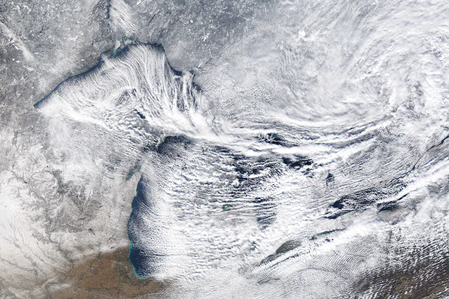
Canadian winds pick up moisture over the Great Lakes, turning it into heavy snowfall on the far shore. NOAA
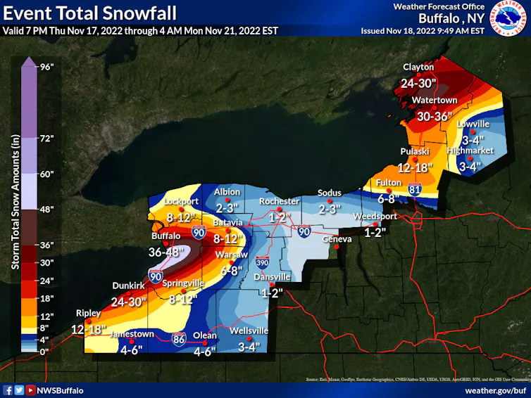
It’s hard for most people to imagine more than 4 feet of snow in one storm, like the Buffalo area was forecast to see this weekend, but these extreme snowfall events happen periodically along the eastern edges of the Great Lakes.
The phenomenon is called “lake-effect snow,” and the lakes themselves play a crucial role.
It starts with cold, dry air from Canada. As the bitter cold air sweeps across the relatively warmer Great Lakes, it sucks up more and more moisture that falls as snow.
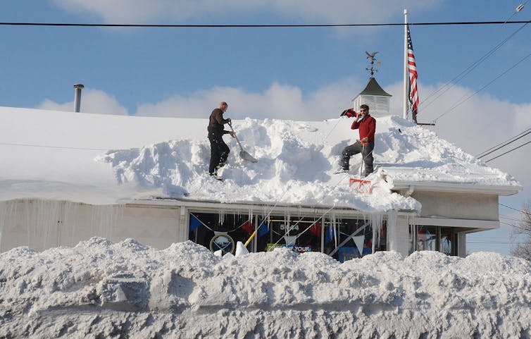
A lake-effect snowstorm in November 2014 buried Buffalo, N.Y., under more than 5 feet of snow and caused hundreds of roofs to collapse.
Patrick McPartland/Anadolu Agency/Getty Images
I’m a climate scientist at UMass Amherst. In the Climate Dynamics course I teach, students often ask how cold, dry air can lead to heavy snowfall. Here’s how that happens.
Join thousands of Canadians who subscribe to free evidence-based news.Get newsletter
How dry air turns into snowstorms
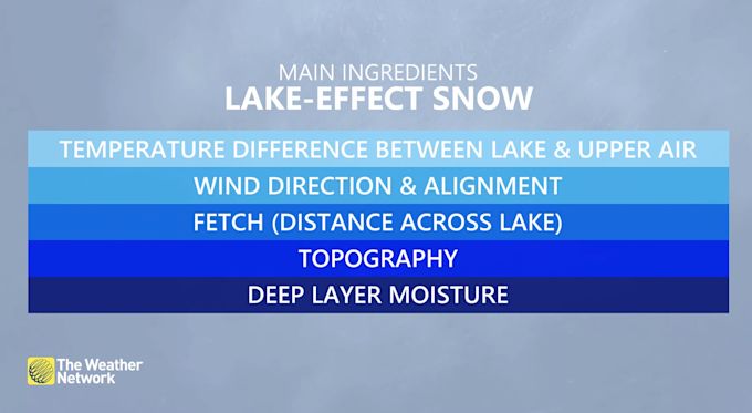
Lake-effect snow is strongly influenced by the differences between the amount of heat and moisture at the lake surface and in the air a few thousand feet above it.
A big contrast creates conditions that help to suck water up from the lake, and thus more snowfall. A difference of 25 degrees Fahrenheit (14 C) or more creates an environment that can fuel heavy snows. This often happens in late fall, when lake water is still warm from summer and cold air starts sweeping down from Canada. More moderate lake-effect snows occur every fall under less extreme thermal contrasts.
I’m a climate scientist at UMass Amherst. In the Climate Dynamics course I teach, students often ask how cold, dry air can lead to heavy snowfall. Here’s how that happens.
Join thousands of Canadians who subscribe to free evidence-based news.Get newsletter
How dry air turns into snowstorms
Lake-effect snow is strongly influenced by the differences between the amount of heat and moisture at the lake surface and in the air a few thousand feet above it.
A big contrast creates conditions that help to suck water up from the lake, and thus more snowfall. A difference of 25 degrees Fahrenheit (14 C) or more creates an environment that can fuel heavy snows. This often happens in late fall, when lake water is still warm from summer and cold air starts sweeping down from Canada. More moderate lake-effect snows occur every fall under less extreme thermal contrasts.
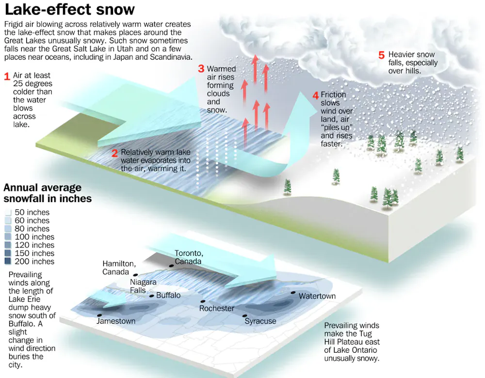
How lake-effect snow works and why western New York get such powerful storms.
Image from 'The AMS Weather Book' by Jack Williams. © 2009 by the American Meteorological Society. Used with permission.
Wind direction is important too. The farther cold air travels over the lake surface, the more moisture is evaporated from the lake. A long “fetch” – the distance over water – often results in more lake-effect snow than a shorter one.
Imagine a wind out of the west that is perfectly aligned so that it blows over the entire 241-mile length of Lake Erie. That’s close to what Buffalo was experiencing the weekend of Nov. 18, 2022.
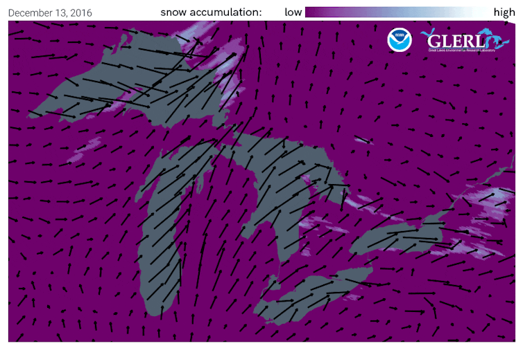
Wind directions from a storm in 2016 shows how lake-effect show piles up. NOAA
Once the snow reaches land, elevation contributes an additional effect. Land that slopes up from the lake increases lift in the atmosphere, enhancing snowfall rates. This mechanism is termed “orographic effect.” The Tug Hill plateau, located between the lake and the Adirondacks in western New York, is well known for its impressive snowfall totals.
In a typical year, annual snowfall in the “lee,” or downwind, of the Great Lakes approaches 200 inches in some places.
Residents in places like Buffalo are keenly aware of the phenomenon. In 2014, some parts of the region received upwards of 6 feet of snowfall during an epic lake-effect event Nov. 17-19. The weight of the snow collapsed hundreds of roofs and led to over a dozen deaths.
Lake-effect snowfall in the Buffalo area is typically confined to a narrow region where the wind is coming straight off the lake. Drivers on Interstate 90 often go from sunny skies to a blizzard and back to sunny skies over a distance of 30 to 40 miles.
The role of climate change
Is climate change playing a role in the lake-effect snow machine? To an extent.
Fall has warmed across the upper Midwest. Ice prevents lake water from evaporating into the overlying air, and it is forming later than in the past. Warmer summer air has led to warmer lake temperature into fall.
Models predict that with additional warming, more lake-effect snow will occur. But over time, the warming will lead to more of the precipitation falling as lake-effect rain, which already occurs in early fall, rather than snow.
Author

Michael A. Rawlins
Associate Director, Climate System Research Center, UMass Amherst
Disclosure statement
Michael A. Rawlins receives funding from the Department of Energy, the National Aeronautics and Space Administration, and the National Science Foundation.
Associate Director, Climate System Research Center, UMass Amherst
Disclosure statement
Michael A. Rawlins receives funding from the Department of Energy, the National Aeronautics and Space Administration, and the National Science Foundation.
Buried: Why the Great Lakes produce some of the world’s heaviest snow
Dennis Mersereau
Dennis Mersereau
WEATHER NETWORK
Digital Writer
Thursday, November 17th 2022, 8:42 pm - Cold winds blowing over a warm lake can produce some of the most dramatic and efficient snowstorms anywhere in the world.
VIDEO Lake-effect snow, how and why it happens
Snow gushed from the sky for three days straight.
Cold winds blowing up the length of Lake Erie set in motion a catastrophe that would damage hundreds of homes and businesses, shut down entire cities for days on end, and even force a mother-to-be to give birth at a fire station because no vehicles could get her to a hospital.
PODCAST: A state of emergency was called for the Great Buffalo Blizzard of 2014
A solid band of lake-effect snow rolled into western New York on November 17, 2014. This unwavering squall was as torrential as it was tenacious, producing whiteout conditions that wouldn’t finally cease until the 19th.
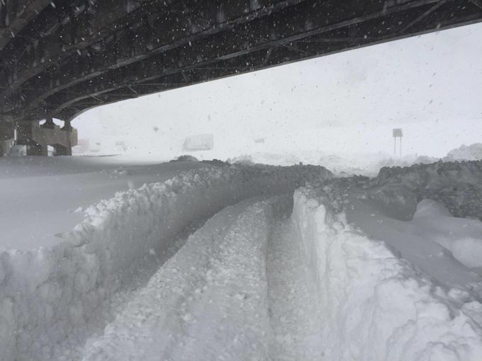
That days-long lake-effect snow event produced as much as 165 cm of snow near Buffalo, New York, burying some homes up to their second floors and immobilizing the area for days.
Western New York’s lake-effect snow disaster underscored one basic fact of living near lakes during the cold season: snow squalls are nothing to sneeze at.
Lake-effect snow and summertime thunderstorms are cousins
Lake-effect snow lands its characteristic punch because it’s born from the same process that creates a towering thunderstorm on a humid summer afternoon.
Snow squalls off the lakes are a product of convection. We experience most lake-effect snow during the fall and early winter months because there’s still a sharp temperature difference between the surface of the lakes and the much chillier winds blowing over the water.
DON'T MISS: Why does your long-range forecast change so often?
Some of that air comes in direct contact with those warmer waters, heating up that shallow layer of air like a camper holding their hands over a fire to stay warm. This air becomes warmer than its surroundings, allowing it to begin rising through the atmosphere.
A bigger difference between the temperature of the lake and the atmosphere above will cause the air to rise even more quickly, feeding the formation of snow showers similar to the way we’d see thunderstorms bubble up on a hot July day.
A dangerous game of fetch
If you can’t stand snow, you don’t want to make fetch happen.
Fetch is the distance that wind travels over open water. A longer fetch means that wind spends more time and travels more distance over the water, a key ingredient to the formation of lake-effect snow.
Stiff winds blowing across the water organize these snow showers into bands, blowing them over the lakeshores and bringing us the rounds of lake-effect that are so familiar during the leadup to the holiday season.
Meteorologists closely watch the direction of the wind for clues about where bands of snow will set up and how heavy they could grow.
A short fetch leads to multiple but narrow bands of snow that can cover a large area with a modest blanket of accumulation. A long fetch, on the other hand, leads to single, thick bands of snow.
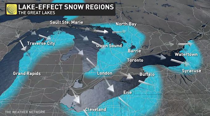
The Great Lakes are king, but it’s a widespread problem
The size, depth, and location of the Great Lakes makes this region prime real estate for lake-effect snow, but this phenomenon is possible across Canada and around the world.
Lake-effect snow is common in southern Manitoba during the early fall before the lakes freeze over. Sea-effect snow—which forms through the same process, just over the ocean instead—is a regular sight throughout the cold season across the Atlantic provinces.
We even see lake- and sea-effect snow around the world. Sapporo, Japan, is one of the snowiest cities in the world due to sea-effect snow burying the city of nearly two million people with metre after metre of powder each season.
Prevailing winds make certain parts of the Great Lakes more prone to these blockbuster snow events than others. Northwesterly winds blowing across Lake Huron and Georgian Bay leave communities like Kincardine, Goderich, and Barrie open to heavy bands of snow.
Lake Erie and Lake Ontario are infamous for their firehose-like bands of snow dumping on the Niagara region, eastern Ontario, and western New York because southwesterly winds achieve an exceptionally long fetch along the entire length of these lakes, feeding intense bands of snow that can last for days.
Frightening intensity meets a knife’s edge
Those legendary bands of snow can produce some of the most intense wintry conditions you’ll ever experience on the planet, akin to a vigorous wintertime thunderstorm.
The most powerful lake-effect events can produce snowfall rates that exceed 10 cm of snow an hour, overwhelming the ability for plows to keep roads clear for more than a few minutes at a time. Convection strong enough to produce that kind of ripping snowfall often leads to vivid lightning and loud claps of thunder.
Digital Writer
Thursday, November 17th 2022, 8:42 pm - Cold winds blowing over a warm lake can produce some of the most dramatic and efficient snowstorms anywhere in the world.
VIDEO Lake-effect snow, how and why it happens
Snow gushed from the sky for three days straight.
Cold winds blowing up the length of Lake Erie set in motion a catastrophe that would damage hundreds of homes and businesses, shut down entire cities for days on end, and even force a mother-to-be to give birth at a fire station because no vehicles could get her to a hospital.
PODCAST: A state of emergency was called for the Great Buffalo Blizzard of 2014
A solid band of lake-effect snow rolled into western New York on November 17, 2014. This unwavering squall was as torrential as it was tenacious, producing whiteout conditions that wouldn’t finally cease until the 19th.
That days-long lake-effect snow event produced as much as 165 cm of snow near Buffalo, New York, burying some homes up to their second floors and immobilizing the area for days.
Western New York’s lake-effect snow disaster underscored one basic fact of living near lakes during the cold season: snow squalls are nothing to sneeze at.
Lake-effect snow and summertime thunderstorms are cousins
Lake-effect snow lands its characteristic punch because it’s born from the same process that creates a towering thunderstorm on a humid summer afternoon.
Snow squalls off the lakes are a product of convection. We experience most lake-effect snow during the fall and early winter months because there’s still a sharp temperature difference between the surface of the lakes and the much chillier winds blowing over the water.
DON'T MISS: Why does your long-range forecast change so often?
Some of that air comes in direct contact with those warmer waters, heating up that shallow layer of air like a camper holding their hands over a fire to stay warm. This air becomes warmer than its surroundings, allowing it to begin rising through the atmosphere.
A bigger difference between the temperature of the lake and the atmosphere above will cause the air to rise even more quickly, feeding the formation of snow showers similar to the way we’d see thunderstorms bubble up on a hot July day.
How warm lakes help create snow showers on a cold dayLake-effect snow takes cold winds blowing over warm waters.
A dangerous game of fetch
If you can’t stand snow, you don’t want to make fetch happen.
Fetch is the distance that wind travels over open water. A longer fetch means that wind spends more time and travels more distance over the water, a key ingredient to the formation of lake-effect snow.
Stiff winds blowing across the water organize these snow showers into bands, blowing them over the lakeshores and bringing us the rounds of lake-effect that are so familiar during the leadup to the holiday season.
Meteorologists closely watch the direction of the wind for clues about where bands of snow will set up and how heavy they could grow.
A short fetch leads to multiple but narrow bands of snow that can cover a large area with a modest blanket of accumulation. A long fetch, on the other hand, leads to single, thick bands of snow.
The Great Lakes are king, but it’s a widespread problem
The size, depth, and location of the Great Lakes makes this region prime real estate for lake-effect snow, but this phenomenon is possible across Canada and around the world.
Lake-effect snow is common in southern Manitoba during the early fall before the lakes freeze over. Sea-effect snow—which forms through the same process, just over the ocean instead—is a regular sight throughout the cold season across the Atlantic provinces.
We even see lake- and sea-effect snow around the world. Sapporo, Japan, is one of the snowiest cities in the world due to sea-effect snow burying the city of nearly two million people with metre after metre of powder each season.
Prevailing winds make certain parts of the Great Lakes more prone to these blockbuster snow events than others. Northwesterly winds blowing across Lake Huron and Georgian Bay leave communities like Kincardine, Goderich, and Barrie open to heavy bands of snow.
Lake Erie and Lake Ontario are infamous for their firehose-like bands of snow dumping on the Niagara region, eastern Ontario, and western New York because southwesterly winds achieve an exceptionally long fetch along the entire length of these lakes, feeding intense bands of snow that can last for days.
WATCH: Why snow squalls are so difficult to predict
Storm Hunter explains why snow squalls are so difficult to predict
Mark Robinson has the details
Frightening intensity meets a knife’s edge
Those legendary bands of snow can produce some of the most intense wintry conditions you’ll ever experience on the planet, akin to a vigorous wintertime thunderstorm.
The most powerful lake-effect events can produce snowfall rates that exceed 10 cm of snow an hour, overwhelming the ability for plows to keep roads clear for more than a few minutes at a time. Convection strong enough to produce that kind of ripping snowfall often leads to vivid lightning and loud claps of thunder.
Multiple feet of snow cover the New York State Thruway near Buffalo, New York, during the lake-effect snowstorm in November 2014. (New York State Police/Facebook)
What’s scarier than the hours-long whiteouts and prolific thundersnow is the fact that these bands can be notoriously hard to predict.
Snow squalls are often so narrow that a couple of kilometres means the difference between a serene wintry scene and a nightmarish disaster that shuts down entire neighbourhoods for days at a time.
Just a tiny shift in wind direction or a tiny wobble in the band itself can shift those mammoth snow totals right along with it. The mounds of snow that fell south of Buffalo in 2014 would’ve hit the centre of the city itself if the band had wiggled just a few kilometres farther north.
Thumbnail image courtesy of Pixabay.
What’s scarier than the hours-long whiteouts and prolific thundersnow is the fact that these bands can be notoriously hard to predict.
MUST SEE: Why Ontario’s ‘snow snake’ caught many–including forecasters–off guard
Snow squalls are often so narrow that a couple of kilometres means the difference between a serene wintry scene and a nightmarish disaster that shuts down entire neighbourhoods for days at a time.
Just a tiny shift in wind direction or a tiny wobble in the band itself can shift those mammoth snow totals right along with it. The mounds of snow that fell south of Buffalo in 2014 would’ve hit the centre of the city itself if the band had wiggled just a few kilometres farther north.
Thumbnail image courtesy of Pixabay.
No comments:
Post a Comment