When Declaring Independence From Empire, Declare Our Interdependence With Each Other
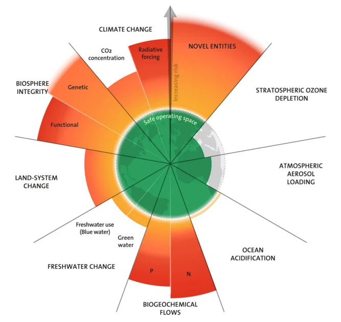
This graphic from Stockholm Resilience Institute depicts how humanity has breached 7 of 9 planetary boundaries that provide it a safe operating space. Most recently, the ocean acidification boundary was crossed. This demonstrates our failure to recognize the common good, the element which links the crises now facing us.
The Common Root of Our Multiple Crises
The world is confronted by a boggling array of crises, testing the limits of human comprehension, let alone hope. In the immediate moment, a crisis of global supply chains caused by the shutdown of the Hormuz Strait threatens not only the greatest energy shock in history – It also imperils food supplies with the cutoff of a substantial portion of global fertilizers.
Lesser known supply streams flowing out of the Persian Gulf are also coming to the fore. Helium vital for making semiconductors and operating medical equipment. Sulphur that is used for fertilizer and industrial processes. Aluminum that taps the cheap energy of the Gulf. Meanwhile, the war itself could escalate uncontrollably. The use of nuclear weapons is discussed as a real possibility. Greater proliferation of nuclear weapons is a likely outcome.
In the backdrop, too much so, the climate crisis sizzles along. 2026 setting up to be hottest year on record after a series of record or near record years. Winter Arctic icepack at the lowest extent before melt season. An El Nino some scientists fear may be the hottest in history, disrupting weather patterns around the world. Shutdown of the North Atlantic circulation seen as increasingly probable, spelling climate chaos around the world. And climate is only one element of an overall global ecological crisis in which multiple planetary boundaries are being breached, making the planet less habitable overall for humanity and all forms of life.
Piling on top of that is the rise of AI and the surveillance state led by Bond-villain-level techlords running corporations such as Palantir. We question who will have a job in a few years, even as wealth increasingly flows to the very top, leaving most behind. Just affording the basics of life is becoming difficult, verging on impossible, for growing numbers.
These are only the highlights of a world seemingly headed for apocalyptic outcomes. Yet if each individual crisis is wrapped in what appears to be irresolvable complexity, there is a common element in all of this. The global political crisis, the ecological crisis, the social-economic crisis, have a singular root – failure to recognize the common good and pursue it as the top priority. Nations, political and economic institutions, and powerful individuals pursue their own interests in a predatory manner, with little regard for the greater whole.
So the ecological commons is polluted and torn up. The atmosphere is made a dump for the spew of industrial civilization. The survival interests nations have in cooperation and peace are ignored in favor of foolish competitions led by national security elites, even as Skynet-like robotic weapons emerge. Corporations and oligarchs pursue their own profit and wealth no matter what the cost to society, while more people are kicked off the bus and to the streets.
This points the way toward the common solution for our converging crises. We must re-focus the common good. We must re-create the commons in our economies, societies and political institutions, and seek the social and political levels at which the common good can most feasibly be realized. In a paradoxical way, this might mean dissolving larger structures that pose impediments to the process. That plays into the larger political questions facing the U.S. and the world.
Toward a Declaration of Interdependence
In my most recent post, I called for a Declaration of Moral Independence from Empire. To say we can no longer affiliate with the increasingly visible evils of empire, with its corruptions, exploitations, wars and genocides. In this is a recognition that the global structure of empire extending its tentacles in all corners of the world acts as an obstacle to the common good. In fact, because empire concentrates power in the hands of the relative few at the expense of the many, it is really the opposite of the common good.
Increasingly, confronted with the lock powerful interests have on the federal government of the U.S., and the deep corruption that possesses federal institutions, people are asking if we might better pursue the common good in different political forms. The new Supreme Court decision gutting the Voting Rights Act and opening the way to Jim Crow congressional redistricting only adds to this sense. Ideas of independence for states such as California, historic regions such as New England, and bioregions such as Cascadia are discussed with a seriousness that was not conceivable a few years back. A nation that could elect Donald Trump twice does not, in the eyes of many, seem to have a united future. Trump has unleashed centrifugal tendencies on the left. If the Democrats sweep back to power, similar tendencies will surge on the right, led by states such as Texas where ideas of secession are strong.
The question through which all efforts must be filtered is interdependence. This is the very root of the common good, a recognition we all need each other. We live in a world of interconnected systems. When they are disrupted, people suffer and die, as we are learning with the Hormuz crisis. I fear most of us have no comprehension of the global food crisis that loss of fertilizer will cause, even as El Nino is disrupting harvests.
We should study the Soviet collapse, how the implosion of its systems led to sharply diminished life expectancy, mass unemployment, and the rise of criminal gangs and oligarchs. If the U.S. broke up in conflict, the results could be at least equally catastrophic. In the U.S., we rely on supply chains that span the continent and the world. Re-localization is a worthy goal and should be pursued, but not as an emergency response.
That is why I have proposed a Declaration of Moral Independence from Empire as a step which potentially preserves our commonalities while setting a path to a different political order. While declaring independence, we must also recognize our interdependence. We must see what draws us together, the common good we must jointly pursue.
As a thought process, consider what Trump and his cronies have cut from the federal budget. Scientific research across many fields, from health to climate and energy. Aid to support poor people in the U.S. and across the world. Public health both internationally and domestically. Disaster response. These cuts undermine the capacity of the federal government to “promote the general welfare” for which the Preamble to the Constitution calls. How can we re-create these vital functions?
Personally, as an inhabitant of Cascadia, I am acutely aware that before it was the name of a bioregion, it was the descriptor for the Cascadia Subduction Zone, a fault line off the coast capable of generating the most powerful type of earthquakes. Someday across Cascadia bridges will be down, power grids collapsed, all the circulatory systems on which we rely for daily life shattered. We’re going to need a lot of help from beyond. While ideas of independence are as strong on the U.S. side of Cascadia as anywhere in the country, we also need to look to networks of interdependence with our neighbors across the continent.
The common good where we can pursue it
A fundamental concept of governance is principle of subsidiarity. Accomplish tasks as close to home as possible. Do locally what can be achieved locally, or even hyperlocally. Situate everything at the most appropriate level, avoiding over-centralization, but centralizing where necessary. Where can we best concentrate the necessary resources? In some cases, such as marshaling response to disasters or building high-speed rail networks, larger structures will be needed. Especially living in a world fraught with increasing climate stress, we will need ways to help each other, in particular to share food when famines break out, as they will.
Through all of this, the key principle must be the common good. At what level can we best pursue it? In some cases it might be the neighborhood. In others the city or state. We are still learning what it means to organize at the bioregional level, though that will be increasingly important as we adapt to our climate-wracked world in our natural settings. And for some issues we will need broader alignment in some form, a reformed national government or new confederation. Of course, on some matters global alignment would be ideal, such as climate action, AI regulation and pandemic response. As we have seen, the Trump Administration is systemically stripping out the federal government’s capacity to pursue the common good in these and other areas. States and cities are stepping up to fill in the gaps, as interstate public health and climate alliances are now doing. It may be that the divisions between people and regions have grown so great that we must seek the common good closer to home, in our states and cities, bioregions and communities. We must seek alignment on the common good wherever we can, at whatever level we can.
If we understand the common root of our multiple global and national crises is the failure to recognize and work together for the common good, we understand the overarching project. To restore the commons, ecologically, politically, socially, economically. To build the institutions of commonality wherever we can, and to instill the principle of commonality in all our institutions. When seeking independence from old structures which have held us back, we must also seek to build and restore structures which strengthen our interdependence. When declaring independence from empire, we must also declare our interdependence upon each other. This is the basis of an order through which we can grapple with our multiple crises and find ways to work and live together. In the end, we survive together or not at all.
This first appeared on Patrick Mazza’s Substack page, The Raven.
To Stay in Our (Human) Wheelhouse Must Be Our Priority

Oneida Lake at Sunset. Photograph Source: John Brighenti – CC BY 2.0
“You can’t crush ideas by suppressing them. You can crush them by ignoring them. By refusing to think, refusing to change. And that’s precisely what our society is doing! …The unadmitted, inadmissable government …rules the… society by stifling the individual mind.” [Contradicting Shevek who calls him“crazy,” Bedap continues] No, brother, I’m sane. What drives people crazy is trying to live outside reality….The reality is pain…But it’s the lies, evasions of reality that drive you crazy…
–Bedap, reproving Shevek, in The Dispossessed by Ursula K.LeGuin
“A scientist can pretend that his work isn’t himself, it’s merely the impersonal truth. An artist can’t hide behind the truth. He can’t hide anywhere.”
–Shevek, in Ibid
By turning away from spiritual truth—by which Guenon meant the esoteric truth at the heart of the ancient religions- modern humanity had guaranteed its descent into confusion and breakdown.
–Paul Kingsnorth, Against the Machine
Sorry – I’m not “over it!” The loss of our coffeeshop after 22 years was profound for me. Although something to be grieved, it has not completely fit the pattern of the loss of a beloved person. Perhaps an indigenous person mourning the loss of their land would best understand this kind of grief, though our Cafe was not snatched from us by trickery and force. Rather, the loss, at least in part, was due to the hazards of staying small and in-place in a “growth economy.” With my faith being so very individual, so “made up,” I could look nowhere for help for what is a spiritual problem. Through these couple of years I have clung to truths I’d learned from experience could keep me from spiritual drowning, one of which is more mundane – keep walking, keep my life and its projects going, trust “the process.”
The other means is not mundane. To speak of it I will use the metaphysically referential terms “horizontal,” referring to relationships on the social, this-world plane, and “vertical,” the spiritual dimension that reaches down to the depths of hell and upwards to heaven and so is “imaginal.”
With the vertical for me having become shaky, much of the spiritual danger comes from the perplexities of horizontal social being. When you’ve lost your compass, and in an ever forward-marching, de-personalized and de-humanizing “Machine” context (I use the term favored by Paul Kingsnorth and other modern-age poets and prophets) that compulsively assures you you don’t need the “hell of other people,” or the hell of your assumed gender or the hell of nature or any of the limitations of being human, horizontal social reality makes for extremely treacherous going – if you still dare to care about unity, that is, and staying human.
In some way, the Cafe’s sacred quality protected me from these dangers and now I must learn to navigate them in its absence, so that this other way I’ve found of dealing with that loss has been to keep a residual faith, no matter what confusions assault me in relation to the people in my life, or in the limited circumference of my life in place, in the inward condition that feels right to my soul. I cling to the rightness in the occasional respite of a relaxed gut, momentary tensionlessness, which feels like grace. It requires trusting that (in a relational, connected, interdependent universe) I’m not supposed to feel damned, forsaken, despised, unwanted, etc. – feelings against which I have no protection in the social world without verticality.
Thus, recovery from this loss of my ‘sacred land’ is a process of recovering inward strength – and I stress, this is the strength and the wisdom I need in order to keep my faith in the rooted, in-place, small-city, family-centered urban life in the Mohawk Valley of New York State I have chosen and that keeps me differentiated from and in resistance to the Machine. But though strength is the goal, much of the time I’m just righting my “boat” after its last capsize; staying in relation to that fearsome and powerful sea of the Unconscious but – so far! – not actually drowning in it.
+++
Last month I made it a point, with Orin in mind, to get to the talk about nearby Oneida Lake, over at the Oneida County History Center. Orin had strong associations with the lake from childhood – his great-uncle Patsy’s camp was the site of family reunions, Sylvan Beach, the most popular resort spot at the east end of the lake, was a regular destination for family picnics. The first summer after we were married his grandmother told us the story as we sat in her kitchen, about taking the canal barge to Sylvan Beach with her young women friends from the factory.
By the end of the talk, besides learning about the communities and traditional economies around the lake (since the native people had been removed, that is) we had been introduced to many worthy folks the speaker had come across in his 51 years (producing 5 books in all) of research on the lake. We were left convinced of the many fine, salt-of-the-earth types in the region; even the “criminals” the fishing pirates, who have defied the state’s fishing laws and the police sent to enforce them, sounded more like “rascals” than criminals. They’ve been largely supported by the communities around the lake in what sounded to me like it could have been a defense of “the commons.”
It took Orin to bring up the real criminals during the q & a, as I knew – or rather feared – he would do. Feared, not – I emphasize – due to his being associated with gangsters, but for a different reason in this post-Cafe phase of our marriage when we no longer share its protection and trust has become more difficult. He told the story I’ve heard countless times, the discovery on that day in 1957 that the stranger staying at Uncle Patsy’s camp, toward whom tough Uncle Patsy was inexplicably being so meek and nice, running to the store to get him cigarettes, etc., was the notorious mafioso Joe Falcone, hiding out from the Appalachin-era anti-crime sweep. The speaker did not pick up on Orin’s story – did he sense an endangerment to his own picture of America the way it used to – and should – be? Was that my fear as well – that is, am I back on the side of the respectable white folks?
+++
In a fabulism of my own, I imagine Orin’s social behavior as remnants of his Sicilian heritage, which, correct or off-base, helps explain their inexplicability to me. They seem to me not so much patriarchal egoism, but a capacity for coldness (or “god-likeness,” in the way the prince in Giuseppe di Lampedusa’s The Leopard put it, at very least indifference to social mores, at worst, there are murders in Orin’s family tree). Not until the morning after – which happened to be Easter morning – did I recall that Orin’s insistence upon bringing up the left-out “darker element” in such respectable social settings, was, in fact, a behavior I had long depended upon him for! It worked, always, like magic, to make me feel socially at ease. His habit of changing the discourse, of bringing his outsider input into the inside had been for me, raised in and entirely conditioned by the genteel, white, middle class, educated “inside,” a gift – maybe a god-like one.
For many years, I did not know why his imperviousness to “what people think,” though it so easily can be interpreted as arrogance, was, in the main such a comforting bulwark for me. It came as a surprise when I at last realized that my capacity to “fit” in the good white liberal social milieu, like glove to hand – sweet as such a harmony is at times – invariably does injury to my soul. That is to say, there’s a subtle but very high a price to the fitting. Down deep this sacrifice of my individuality causes pain. On my own, I have little-to-no defense against “what other people think.” Orin, and the Cafe business we made together, was my defense against feeling this pain. Partnered to that Sicilian taciturnity built upon centuries of deep peasant mistrust of church and state, enabled me to stave off the caving to the inevitability of the Machine, to say no to all the voices telling us how a business should be run, to behave just as if we were protecting something sacred.
In the microcosm of myself, the danger in having no onboard protection against the social status quo, is real. When the pain gets ignored, my soul naturally protests, but the protest has nowhere to go except against myself. This defenselessness makes me – and, I suggest, others who, like me, carry the trauma of “mother wound” – desperate to be seen, validated (loved), in the one world I know: white liberal (capitalist) reality. Thus embraced in liberal reality one is still capable of doing good, but its a good that has no power against the Machine. One’s resistance to tyranny will not go to its radical root – partnered with a Sicilian or no – unless, one reach transcendent truth – the metaphysicalreality that’s “independent of all our struggles and notions.” That reality is indiscernible except by those who have the strength of their own goodness, which is individuality.
Without “metaphysically authenticated” individuality, no matter how much money and influence one has attained, one remains a slave to the Machine. That is, indifference to the real pain that comes with loss of my autonomy keeps me on the side of the master – the ego, incapable of opposing the given in materialist techno-capitalism because I’m busy drowning in it! Maintaining social/economic insiderhood at the expense of one’s soul that wants its individuality one becomes an enemy to oneself.
I may just be an extreme case, of course. But if I’m not so extreme, then this dilemma I describe – this kind of “innate cowardice” may be, for those of us who “pass” in liberal white reality, the challenge for individuality under what the character Shevek in Ursula K. LeGuin’s The Dispossessed calls “unadmitted, inadmissible” government. In any gathering of the very best of “my people,” in my one and only social world, I can never trust the other in me is included, because it is not! Excepting my own social enclave consisting of people powerfully attracted to our coffeeshop over 22 years, there are precious few social encounters I can fully trust. In the story I tell myself, the problem for me now, after having relied upon Orin to provide that indifference to what other people think, which, no question, allowed our Cafe its sacred aspect, is to have my own protection.
Rereading The Dispossessed in our book club turned out to be timely indeed! LeGuin tells so well the story of that struggle to preserve “autonomy of conscience even at the cost of becoming eccentric.” This is the struggle of the protagonist, (motherless!) Shevek, and his friends, living in a separate Anarchist world on a separate planet. The fact that even an anarchist world could not grant individuality as a right tells me there is something about this struggle that is universal, macrocosmic, as well as personal and microcosmic. If my writing communicates anything of value to other people, may it be that others who find the path to authentic strength to be nearly insurmountably difficult be assured they are not alone! I suspect there are others who passively accept the pained (traumatized) insider as personal problem, treatable with medication if one is lucky, or they find some other way around the dilemma of strength – addictions work well – never able to manage the difficult feat of being both good and strong. Further, I suspect that a strength that does not need protection is not strength but some form or other of unquestioned obedience to the Machine-as-God.
+++
By now, the dark alternative to the kind of individuality that can protect the soul from the smiley-face oppressor, is obvious; it’s fascism, yes, but fascism is also the bogeyman we won’t fully believe in until the brownshirts come knocking on our door. The subtler erasures of human efficacy, the meaning of being/ doing things at the humanly interactive level, staying within the lowlier, “hands-on” human “wheelhouse” is what should alarm us now. Every turn to rescue by technology reels us in (or out), except insofar as we do not cease our obedient commitment to the soul’s verticality, to reclaiming behaviors and knowledge largely already lost. I refer to the lost arts of making by hand, but even more so, left with just horizontal relatedness, to loss of ability to protect/defend the sacred, the human, the vulnerable. That verticality, with its illogical and unnecessary veneration of tradition, of loyalty to places and people, of a backwards conservatism, a hierarchy of good, needs our consciousness or it will be hierarchy of the worst.
Late as it is in this steady process of machinification, to give our loyalty to the most threatened thing in us – to the vulnerable, imaginative soul where lies true strength – it’s not too late. It is both the lowliest and the highest, location of the meeting of vertical and horizontal, which is in Christian terms the cross. While it wreaks mental havoc in the individual when denied, when obeyed consciously, in conscious creativity, it enlarges the individual into full social being, which is to be, not merely “good,” but an avatar of love. That is, we’re called to be artists who “cannot hide anywhere.”
Anyone reading my work can see I have far to go in becoming more adept at not hiding! Fortunately for me, there are still reminders we gave ourselves, back in the Cafe’s heyday, a trail of bread crumbs leading back to soul’s truth. Among them, and still going, are The Other Side’s artistic productions, its ongoing cultivation of the creative soil in Utica. This winter-into-spring has brought the birth of a bi-weekly music jam in our nonprofit space, and a readers’ theater has also launched. Last Friday, the jazz series we’ve kept going for 16 years featured guest Marko Marcinko, from PA. His powerful drumming as leader seemed to call forth similar assertiveness from the other musicians. The space was filled with energy. It brought back to me that old feeling, the power and excitement of being in the room with people actively making art, vehicles for the creative spirit. As good an exemplification as one can find for the world that can resist the Machine – one enervated by joy.