By Brian Lada, Accuweather.com
1/5

The Sanibel Causeway on Florida's Gulf Coast was washed out by Hurricane Ian last September. File Photo by POC3 Riley Perkofski/U.S. Coast Guard | License Photo
Hurricane Ian was the storm that defined the 2022 Atlantic Hurricane season with communities across Florida still grappling with the aftermath of one of the most catastrophic weather events in the United States last year.
On Monday, the National Hurricane Center released its final analysis of the monstrous storm. When reanalyzing data from the hurricane, meteorologists found that it was stronger than previously thought, propelling Ian into the upper echelon of hurricane intensity.
Just seven hours before making landfall on Sept. 28, peak winds in the eye of Hurricane Ian reached 160 mph, meeting the criteria of a Category 5 hurricane on the Saffir-Simpson Hurricane Wind Scale, the NHC said in the report. Previously, meteorologists believed that winds topped out at 155 mph, just 2 mph shy of Category 5 status.
Ian did not remain a Category 5 storm for long, and the hurricane lost some wind intensity right before landfall.
"Environmental conditions became less favorable soon thereafter, and Ian weakened slightly during the next several hours before it made landfall on the barrier island of Cayo Costa, Florida, at 19:05 UTC [3:05 p.m. EDT] 28 September with an intensity of 130 kt [150 mph]," the report stated.

A satellite image of Hurricane Ian on Sept. 28. A reanalysis by the National Hurricane Center found Ian was a Category 5 storm at this time but weakened shortly before landfall. Image courtesy of AccuWeather
Since record-keeping began, only 39 hurricanes have been classified as Category 5, with maximum sustained winds of at least 157 mph. However, only four made landfall on the U.S. mainland at such a magnitude: Hurricane Michael (2018), Hurricane Andrew (1992), Hurricane Camille (1969) and the Labor Day Hurricane (1935).
On Wednesday, the World Meteorological Organization announced that Ian would be retired from the list of hurricane names due to the death and destruction that it caused across the Caribbean and the United States.
It is not uncommon for the category of tropical systems to change after a post-storm analysis.
Seven months after Hurricane Michael slammed into the Florida Panhandle as a Category 4 storm, the NHC released a report saying that Michael briefly reached Category 5 status as it made landfall.
The category may be different in history books, but the slight change in wind speed is negligible when looking at the real-life impacts the storm had on the lives of people in the path of the hurricane.
The NHC echoed this sentiment in its reanalysis of Ian, stating that the NHC track issued during the storm has an uncertainty of around 10 and that "there is very little practical difference" between Ian being a Category 4 storm with winds of 155 mph or a Category 5 storm with winds of 160 mph.
Florida will once again be at risk for land-falling tropical systems this year, including the regions that faced Ian's wrath.
According to AccuWeather meteorologists, the 2023 Atlantic hurricane season will spawn 11 to 15 named storms and four to eight hurricanes. Additionally, two to four of these tropical systems will have a direct impact on the United States.
"The highest chance of direct and significant impacts will be from the Florida Panhandle around the entire state of Florida to the Carolina coast," said senior meteorologist and hurricane expert Dan Kottlowski, who has been issuing forecasts for AccuWeather for over four decades.
"There appears to be a lower chance for direct impacts over the western Gulf of Mexico and for the northeast U.S.," he said.
Hurricane Ian leaves trail of destruction in Florida
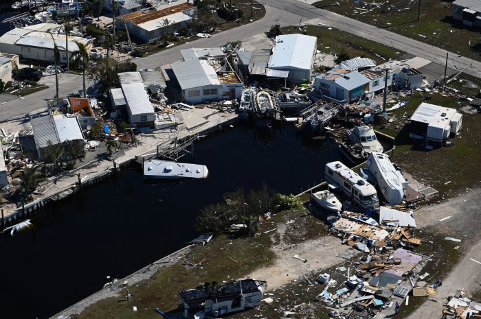
A U.S. Coast Guard MH-60 Jayhawk aircrew conducts flights over the southwest coast of Florida on October 1, 2022 to survey the damage from Hurricane Ian.
Photo by POC3 Riley Perkofski/U.S. Coast Guard | License Photo
No comments:
Post a Comment