Showing posts sorted by relevance for query CAHOKIA. Sort by date Show all posts

Saturday, February 01, 2020

New Study Debunks Myth Of Cahokia's Native American Lost Civilization

1/27/2020

A University of California, Berkeley, archaeologist has dug up ancient human feces, among other demographic clues, to challenge the narrative around the legendary demise of Cahokia, North America's most iconic pre-Columbian metropolis.


Painting of the Cahokia Mounds by William R. Iseminger [Credit: Cahokia Mounds Historic State Site]

In its heyday in the 1100s, Cahokia -- located in what is now southern Illinois -- was the center for Mississippian culture and home to tens of thousands of Native Americans who farmed, fished, traded and built giant ritual mounds.

By the 1400s, Cahokia had been abandoned due to floods, droughts, resource scarcity and other drivers of depopulation. But contrary to romanticized notions of Cahokia's lost civilization, the exodus was short-lived, according to a new UC Berkeley study.

The study takes on the "myth of the vanishing Indian" that favors decline and disappearance over Native American resilience and persistence, said lead author A.J. White, a UC Berkeley doctoral student in anthropology.

"One would think the Cahokia region was a ghost town at the time of European contact, based on the archaeological record," White said. "But we were able to piece together a Native American presence in the area that endured for centuries."

The findings, just published in the journal American Antiquity, make the case that a fresh wave of Native Americans repopulated the region in the 1500s and kept a steady presence there through the 1700s, when migrations, warfare, disease and environmental change led to a reduction in the local population.

White and fellow researchers at California State University, Long Beach, the University of Wisconsin-Madison and Northeastern University analyzed fossil pollen, the remnants of ancient feces, charcoal and other clues to reconstruct a post-Mississippian lifestyle.

Their evidence paints a picture of communities built around maize farming, bison hunting and possibly even controlled burning in the grasslands, which is consistent with the practices of a network of tribes known as the Illinois Confederation.

Unlike the Mississippians who were firmly rooted in the Cahokia metropolis, the Illinois Confederation tribe members roamed further afield, tending small farms and gardens, hunting game and breaking off into smaller groups when resources became scarce.


Credit: Herb Roe, University of California - Berkeley

The linchpin holding together the evidence of their presence in the region were "fecal stanols" derived from human waste preserved deep in the sediment under Horseshoe Lake, Cahokia's main catchment area.

Fecal stanols are microscopic organic molecules produced in our gut when we digest food, especially meat. They are excreted in our feces and can be preserved in layers of sediment for hundreds, if not thousands, of years.

Because humans produce fecal stanols in far greater quantities than animals, their levels can be used to gauge major changes in a region's population.

To collect the evidence, White and colleagues paddled out into Horseshoe Lake, which is adjacent to Cahokia Mounds State Historical Site, and dug up core samples of mud some 10 feet below the lakebed. By measuring concentrations of fecal stanols, they were able to gauge population changes from the Mississippian period through European contact.

Fecal stanol data were also gauged in White's first study of Cahokia's Mississippian Period demographic changes, published last year in the Proceedings of the National Academy of Sciences. It found that climate change in the form of back-to-back floods and droughts played a key role in the exodus of Cahokia's Mississippian inhabitants.

But while many studies have focused on the reasons for Cahokia's decline, few have looked at the region following the exodus of Mississippians, whose culture is estimated to have spread through the Midwestern, Southeastern and Eastern United States from 700 A.D. to the 1500s.

White's latest study sought to fill those gaps in the Cahokia area's history.

"There's very little archaeological evidence for an indigenous population past Cahokia, but we were able to fill in the gaps through historical, climatic and ecological data, and the linchpin was the fecal stanol evidence," White said.

Overall, the results suggest that the Mississippian decline did not mark the end of a Native American presence in the Cahokia region, but rather reveal a complex series of migrations, warfare and ecological changes in the 1500s and 1600s, before Europeans arrived on the scene, White said.

"The story of Cahokia was a lot more complex than, 'Goodbye, Native Americans. Hello, Europeans,' and our study uses innovative and unusual evidence to show that," White said.

Author: Yasmin Anwar | Source: University of California - Berkeley [January 27, 2020]

Monday, December 06, 2021

Augmented reality tours open as push to make Cahokia Mounds a National Park advances


Beth Hundsdorfer
Sat, December 4, 2021, 8:00 AM·2 min read

There’s a new way to explore an ancient place in Illinois.

Visitors of Cahokia Mounds State Historic Site can try experiencing it in “augmented reality,” or AR, to see the Grand Plaza as it appeared 1,000 years ago, the Palisade as it once stood and the exterior and interior of the temple that once stood atop Monks Mound.

Cahokia Mounds was the central hub and largest city built by the Mississippian culture of Native Americans. The site has been recognized as a National Historic Landmark, an Illinois State Historic Site and a World Heritage Site by the United Nations.

At its height, Cahokia stretched over six square miles and was home to 10,000 to 20,000 people. Set near the Mississippi River, Cahokia was a trade hub and an agriculture production site. There were 120 mounds in Cahokia, including the largest, Monks Mound. The Mississippians built them between 900 and 1400 AD, according to archeologists.

The augmented reality tour unveiling comes as there is a renewed push to make the site a part of the federal National Park System.

Illinois’ U.S. senators Dick Durbin and Tammy Duckworth, both Democrats, sent a letter to President Joe Biden Tuesday asking him to incorporate Cahokia Mounds into the National Park System. In 2016, a study found that Cahokia Mounds met all four of the criteria – significance, suitability, feasibility, and need for National Park Service management.

“We write to encourage you to use your authority under the Antiquities Act to designate the Cahokia Mounds State Historic Site as a unit of the National Park System,” Duckworth and Durbin wrote in the letter to Biden. “We support elevating, protecting, and sharing this important archeological and cultural resource that represents the people and landscapes that once made up one of America’s first cities in the Western Hemisphere.”

In April, Durbin introduced the Cahokia Mounds Mississippian Culture National Historical Park Act to change the current designation as a National Historic Landmark to a National Historic Park. This move would add protections for the ancient mounds that straddle St. Clair and Madison counties.

Visitors can experience the site in augmented reality by downloading the app at a cost of $4.99 to their Apple device, or they can rent an iPad for $15 at the site. Developers spent five years creating the new application that allows visitors to step back and experience Cahokia as it once was.

“Once the app is downloaded to your device, visit Cahokia Mounds and begin your tour at the Monks Mound parking lot where the first ‘Waypoint’ can be found,” Cahokia Mounds site superintendent Lori Belknap said in a news release. “These Waypoints are unique images mounted to concrete blocks and will launch the app once scanned.”

The Cahokia AR Tour application was developed and produced by the Cahokia Mounds Museum Society and Schwartz and Associates Creative of St. Louis and was funded by two grants from the National Endowment for the Humanities.

Saturday, May 16, 2020

Cahokia's rise parallels onset of corn agriculture

UNIVERSITY OF ILLINOIS AT URBANA-CHAMPAIGN, NEWS BUREAU
IMAGE
IMAGE: CORN CULTIVATION BEGAN IN THE VICINITY OF THE CITY OF CAHOKIA BETWEEN A.D. 900 AND 1000, RESEARCHERS REPORT IN A NEW STUDY. ITS ARRIVAL MAY HAVE CONTRIBUTED TO THE ABRUPT... view more 
CREDIT: GRAPHIC BY DIANA YATES
CHAMPAIGN, Ill. -- Corn cultivation spread from Mesoamerica to what is now the American Southwest by about 4000 B.C., but how and when the crop made it to other parts of North America is still a subject of debate. In a new study, scientists report that corn was not grown in the ancient metropolis of Cahokia until sometime between A.D. 900 and 1000, a relatively late date that corresponds to the start of the city's rapid expansion.
The findings are published in the journal American Antiquity.
The research team determined the age of charred corn kernels found in homes, shrines and other archaeological contexts in and around Cahokia. The researchers also looked at carbon isotopes in the teeth and bones of 108 humans and 15 dogs buried in the vicinity.
Carbon-isotope ratios differ among food sources, with isotope ratios of corn being significantly higher than those of almost all other native plant species in the region. By analyzing the ratio of carbon 12 to carbon 13 in teeth and bones, the team determined the relative proportion of different types of foods the people of Cahokia ate in different time periods.
The corn remnants and isotope analyses revealed that corn consumption began in Cahokia between 900 and 1000. This was just before the city grew into a major metropolis.
"There's been an idea that corn came to the central Mississippi River valley at about the time of Christ, and the evolution of maize in this part of the world was really, really slow," said retired state archaeologist Thomas Emerson, who led the study. "But this Cahokia data is saying that no, actually, corn arrived here very late. And in fact, corn may be the foundation of the city."
The research team included Illinois State Archaeological Survey archaeobotanist Mary Simon; bioarchaeologist Kristin Hedman; radiocarbon dating analyst Matthew Fort; and former graduate student Kelsey Witt, now a postdoctoral researcher at Brown University.
Beginning in about 1050, Cahokia grew from "a little village of a few hundred people to part of a city with 5,000 to 10,000 people in an archaeological instant," Emerson said. The population eventually expanded to at least 40,000. This early experiment in urban living was short-lived, however. By 1350, after a period of drought and civil strife, most of the city's population had dispersed.
Scientists who theorize that corn came to the central Mississippi River valley early in the first millennium A.D. are overlooking the fact that the plant had to adapt to a completely different light and temperature regime before it could be cultivated in the higher latitudes, said Simon, who conducted an exhaustive analysis of corn kernels found at Cahokia and elsewhere in the Midwest.
"Corn was originally cultivated in Mesoamerica," she said. "Its flowering time and production time are controlled by the amount of sunlight it gets. When it got up into this region, its flowering was no longer corresponding to the available daylight. If you planted it in the spring, it wouldn't even start to flower until August, and winter would set in before you could harvest your crop."
The plant had to evolve to survive in this northerly climate, Simon said.
"It was probably only marginally adapted to high latitudes in what is now the southwestern United States by 0 A.D.," she said. "So, the potential for successful cultivation in the Midwest at this early date is highly problematic."
When they analyzed the carbon isotopes in the teeth and bones of 108 individuals buried in Cahokia between 600 and 1400, researchers saw a signature consistent with corn consumption beginning abruptly between 950 and 1000, Hedman said. The data from dogs buried at and near Cahokia also corresponded to this timeline.
"That's where you see this big jump in the appearance of corn in the diet," Hedman said. "This correlates very closely with what Mary Simon is finding with the dates on the maize."
"Between 900 and 1000 is also when you start to see a real shift in the culture of Cahokia," Emerson said. "This was the beginning of mound construction. There was a massive growth of population and a dramatic shift in ideology with the appearance of fertility iconography."
Artifacts uncovered from Cahokia include flint-clay figurines of women engaged in agricultural activities and vessels marked with symbols of water and fertility. Some of the items depict crops such as sunflowers and squash that predated the arrival of corn.
"It wasn't like the Cahokians didn't already have an agricultural base when corn arrived on the scene," Simon said. "They were preadapted to the whole idea of cultivation."
The absence of corn iconography in artifacts from the city reflects corn's status as a relative newcomer to the region at the time Cahokia first flourished, Emerson said.
Built near present-day St. Louis, the ancient city of Cahokia was an early experiment in urban living.
###
The Illinois Department of Transportation and ISAS supported this research. ISAS is a division of the Prairie Research Institute at the University of Illinois at Urbana-Champaign.
Editor's notes:
The paper "Isotopic confirmation of the timing and intensity of maize consumption in Greater Cahokia" is available online and from the U. of I. News Bureau

Tuesday, April 13, 2021


Why was the ancient city of Cahokia abandoned? New clues rule out one theor
y.

Glenn Hodges
NATIONAL GEOGRAPHIC
4/12/2021


About a thousand years ago, a city grew in the floodplain known as the American Bottom, just east of what is now St. Louis in Illinois. In a matter of decades, it became the continent’s largest population center north of Mexico, with perhaps 15,000 people in the city proper and twice as many people in surrounding areas. A couple centuries after its birth it went into decline, and by 1400 it was deserted.

© Photograph by Ira Block, Nat Geo Image Collection Cahokia's central plaza is now part of a 2,200-acre historical site.

The story of Cahokia has mystified archaeologists ever since they laid eyes on its earthen mounds—scores of them, including a 10-story platform mound that until 1867 was the tallest manmade structure in the United States. They don’t know why Cahokia formed, why it grew so powerful, or why its residents migrated away, leaving it to collapse. Hypotheses are abundant, but data are scarce.


Now an archaeologist has likely ruled out one hypothesis for Cahokia’s demise: that flooding caused by the overharvesting of timber made the area increasingly uninhabitable. In a study published recently in the journal Geoarchaeology, Caitlin Rankin of the University of Illinois not only argues that the deforestation hypothesis is wrong, but also questions the very premise that Cahokia may have caused its own undoing with damaging environmental practices.

“Cahokia was the most densely populated area in North America prior to European contact,” she says. “Sometimes we think that big populations are the problem, but it’s not necessarily the population size. It’s how they’re managing and exploiting resources.”

Logical sense vs data


In 1993, two researchers from Southern Illinois University Edwardsville, Neal Lopinot and William Woods, suggested that perhaps Cahokia failed because of environmental degradation. They hypothesized that Cahokians had deforested the uplands to the east of the city, leading to erosion and flooding that would have diminished their agricultural yields and flooded residential areas.

Given the clear evidence that Cahokians had cut down thousands of trees for construction projects, the “wood-overuse hypothesis” was tenable. It fit the available data and made logical sense, and the archaeological community largely embraced it as a possible—or even likely—contributor to Cahokia’s decline. But little was done to test it.

In 2017, Rankin, then a doctoral student at Washington University in St Louis (where she’s now a research geoarchaeologist), began excavating near one of Cahokia’s mounds to evaluate environmental change related to flooding. She discovered something she hadn’t been expecting to find: clear evidence that there had been no recurrent flooding of the sort predicted by the wood-overuse hypothesis.

Her research showed that the soil on which the mound had been constructed was stable during the time of Cahokian occupation. The mound had been in a low-lying area near a creek that would likely have flooded according the wood-overuse hypothesis, but the soil showed no evidence of flood sediments.

Those results led Rankin to question the assumptions that led not just to that particular hypothesis, but to all the environmental narratives of Cahokia’s decline. The idea that societies fail because of resource depletion and environmental degradation—sometimes referred to as ecocide—has become a dominant explanatory tool in the last half century.

And the reason for that is clear: We do see that happening in past societies, and we fear that it is happening in our own. But our present environmental crisis might be inclining us to see environmental crises in every crevice of humanity’s past, Rankin says, whether they were actually there or not.

“The people who lived here in North America before the Europeans—they didn’t graze animals, and they didn’t intensively plow. We look at their agricultural system with this Western lens, when we need to consider Indigenous views and practices,” Rankin says.

A difference of worldview


Cahokians were part of what anthropologists call Mississippian culture—a broad diaspora of agricultural communities that stretched throughout the American Southeast between 800 and 1500 A.D. They cultivated corn and other crops, constructed earthen mounds, and at one point gathered into a highly concentrated urban population at Cahokia. Whether that was for political, religious, or economic reasons is unclear. But it’s not likely that they saw natural resources as commodities to be harvested for maximum private profit.

Cahokians cut a lot of trees—thousands of them were used to build what archaeologists believe were defensive fortifications—but that doesn’t mean they were treating them as fungible goods, or harvesting them in unsustainable ways, the way European-Americans often did. Maybe they were heedless of their environment and maybe they weren’t, Rankin says, but we certainly shouldn’t assume they were unless there’s evidence of it.

“Look at what happened with the bison,” Rankin says. Plains Indians hunted them sustainably. But “Europeans came in and shot all of them. That’s a Western mentality of resource exploitation—squeeze everything out of it that you can. Well that’s not how it was in these Indigenous cultures.”

Tim Pauketat, a leading Cahokia researcher and Rankin’s supervisor at the University o
f Illinois, agrees that the difference in cultural worldviews needs to be considered more seriously. “We’re moving away from a Western explanation—that they overused this or failed to do that—and instead we’re appreciating that they related to their environment in a different way.”

And that suggests that hypotheses for Cahokia’s decline and collapse are likely to become more complex. Tristram Kidder, an anthropologist at Washington University in St. Louis who chaired Rankin’s dissertation committee, says, “There is a tendency for people to want these monocausal explanations, because it makes it seem like there might be easy solutions to problems.”

Kidder teaches a class on climate change, and he says that’s a constant temptation, not just for the students but for himself—to try to master the problem by oversimplifying it. If Cahokians had just stopped cutting down trees, everything would have been fine. If we only started driving electric cars, everything will be fine. But the reality is much more complex than that, he says, and we have to grapple with that complexity.

Lopinot, one of the archaeologists who originally proposed the wood-overuse hypothesis in 1993, and who is now at Missouri State University, welcomes Rankin’s research. He knew at the time he presented his hypothesis that it was just a reasonable attempt to make sense of a mystery.

“Cahokia’s decline wasn’t something that happened overnight,” he says. “It was a slow demise. And we don’t know why people were leaving. It might have been a matter of political factionalization, or warfare, or drought, or disease—we just don’t know.


There are clues. In later years, Cahokians built a stockade encircling central Cahokia, suggesting that inter-group warfare had become a problem. And there is preliminary data suggesting there may have been a major drought in the region that would have made food production challenging. But those clues still need to be investigated, researchers say.

“Archaeology is not like physics, where you can set up controlled experiments and get the answers you’re looking for,” Rankin says. You have to get out there and dig, and you never know what you are going to find.


Saturday, July 23, 2022

North ‘plaza’ in Cahokia was likely inundated year-round, study finds

Peer-Reviewed Publication

UNIVERSITY OF ILLINOIS AT URBANA-CHAMPAIGN, NEWS BUREAU

wetland with stumps and logs 

IMAGE: RESEARCHERS TOOK SAMPLES FROM NEARBY WETLANDS TO DETERMINE THE ENVIRONMENTAL HISTORY OF THE NORTH PLAZA IN CAHOKIA. view more 

CREDIT: PHOTO COURTESY CAITLIN RANKIN

CHAMPAIGN, Ill. — The ancient North American city of Cahokia had as its focal point a feature now known as Monks Mound, a giant earthwork surrounded on its north, south, east and west by large rectangular open areas. These flat zones, called plazas by archaeologists since the early 1960s, were thought to serve as communal areas that served the many mounds and structures of the city.

New paleoenvironmental analyses of the north plaza suggest it was almost always underwater, calling into question earlier interpretations of the north plaza’s role in Cahokian society. The study is reported in the journal World Archaeology.

Cahokia was built in the vicinity of present-day St. Louis, beginning in about A.D. 1050. It grew, thrived for more than 300 years and was abandoned by 1400. Many mysteries surround the culture, layout and architecture of the city, in particular its relationship to water. Cahokia was built in a flood plain below the confluence of the Mississippi and Illinois rivers and would have been regularly infiltrated with flowing water, said Caitlin Rankin, a geoarchaeologist at the Illinois State Archaeological Survey who conducted the new research.

“Cahokia is the largest archaeological site in North America, but only about 1% of it has been excavated, so there’s so much about the site that we don’t know,” Rankin said.

Early in her encounters with the city’s layout, Rankin was baffled by the location and height of the north plaza.

“It’s a really strange area because it’s at a very low elevation, like the lowest elevation of the site,” she said. “And it’s in an old meander scar of the Mississippi River.”

Two creeks ran through the area, and it likely flooded whenever the Mississippi swelled after heavy rains.

To investigate the site, Rankin conducted test excavations and extracted sediment cores around the four mounds that define the north plaza. She also took soil samples in the same meander scar less than 5 kilometers from the plaza and analyzed stable carbon isotopes in these modern soils to determine isotope differences between wetlands, seasonal wetlands and prairie environments. Comparing these with carbon isotopes from ancient soils chronologically associated with the mounds gave insight into what types of plants had grown there in the past.

“What I learned is that this area remained wet throughout the year,” Rankin said. “There may have been some seasonal dryness, but overall, it was a wetland.”

Her findings challenge previous notions about this site being a plaza, which is generally thought of as a dry open area across which people walk and congregate. “Generally, those places aren’t underwater,” Rankin said.

How the north plaza was used remains a mystery, she said, but the study adds to the evidence that water was a central element of the city.

“Water was important to the people of Cahokia for a number of reasons,” she said. “They had a whole agricultural suite of wetland plants that they domesticated and relied on as food.” Water also was essential to their trade with people up and down the Mississippi River. And the cosmological beliefs of many Indigenous groups include creation stories that involve complex interactions with sky, water and earth.

“At Cahokia, you have these mounds emerging from this watery sphere,” she said. “And so that was a significant feature that probably resonated with their creation stories and their myths and their worldview.”

The Illinois State Archaeological Survey is a division of the Prairie Research Institute at the University of Illinois Urbana-Champaign.

The National Geographic Society and National Science Foundation supported this work.

Editor’s notes

To reach Caitlin Rankin, email rankinc@illinois.edu

The paper “The exceptional environmental setting of the north plaza, Cahokia Mounds, Illinois, USA” is available online and from the U. of I. News Bureau.

DOI: 10.1080/00438243.2022.2077824


CAPTION

The study focused on the north plaza, an expanse at a low elevation that is almost always inundated with water.

CREDIT

Photo courtesy Caitlin Rankin


CAPTION

Sediments from excavations at Mound 5 reveal that the north plaza was a wetland prior to, and after, mound construction.

CREDIT

Photo courtesy Caitlin Rankin

CAPTION

Caitlin Rankin stands in a trench dug in Mound 16, one of four mounds that delineate the north plaza.

CREDIT

Photo by Ann Merkle

Wednesday, July 03, 2024


New study adds to mystery of Cahokia exodus


WASHINGTON UNIVERSITY IN ST. LOUIS
Cahokia Mounds 

IMAGE: 

THE REMAINS OF THE MOST SOPHISTICATED PREHISTORIC NATIVE CIVILIZATION NORTH OF MEXICO ARE PRESERVED AT CAHOKIA MOUNDS STATE HISTORIC SITE IN ILLINOIS. ARCHAEOLOGIST NATALIE MUELLER'S NEW STUDY CASTS DOUBT ON A POPULAR THEORY ABOUT WHY THE ANCIENT CITY WAS ABANDONED.

view more 

CREDIT: PHOTO: JOE ANGELES / WASHINGTON UNIVERSITY


Nine hundred years ago, the Cahokia Mounds settlement just across the Mississippi River from present-day St. Louis bustled with roughly 50,000 people in the metropolitan area, making it one of the largest communities in the world. By 1400, however, the once-popular site was practically deserted, a mass departure that remains shrouded in mystery.

One popular theory is that the Cahokia residents abandoned the settlement after a massive crop failure brought on by a prolonged drought. But a new study in the journal The Holocene by Natalie Mueller, assistant professor of archaeology in Arts & Sciences at Washington University in St. Louis, and Caitlin Rankin, PhD ’20, suggests the Cahokians likely had other reasons to leave town.

Rankin dug deep into the soil at the historic Cahokia site to collect isotopes of carbon, atoms left behind by the plants growing when the human population collapsed and drought was common across the Midwest.

All plants use one of two types of carbon, Carbon 12 and Carbon 13, for photosynthesis, but not all plants do photosynthesis the same way. Plants adapted to dry climates — including prairie grasses and maize, an important new crop during the Cahokia period — incorporate carbon into their bodies at rates that leave behind a tell-tale signature when the plants die and decay.

Most of the other plants that the Cahokians would have harvested for food — including squash, goosefoot and sumpweed — will leave a different signature, one they share with plants from wetlands and native forests.

Rankin’s samples showed that ratios of Carbon 12 and Carbon 13 stayed relatively consistent during that crucial period — a sign there was no radical shift in the types of plants growing in the area. “We saw no evidence that prairie grasses were taking over, which we would expect in a scenario where widespread crop failure was occurring,” Mueller said.

The Cahokians are known for their ingenuity, and Rankin said they may have had the engineering and irrigation skills to keep crops flourishing under difficult conditions. “It’s possible that they weren’t really feeling the impacts of the drought,” said Rankin, now an archaeologist with the Bureau of Land Management in Nevada.

Mueller added that the sophisticated society that blossomed at Cahokia almost certainly included a storage system for grains and other foods. Residents also enjoyed a varied and diverse diet — including fish, birds, deer, bear and forest fruits and nuts — that would have kept them nourished even if a few food sources disappeared.

To get a better grasp of the diets and agricultural practices of Indigenous people of the Midwest, Mueller hopes to build a database that collects paleo-botanical evidence from across the region. “Gathering that information would help us see if people switched to different crops in response to climate change,” she said. She’s also planning to grow certain food crops in controlled conditions on campus to understand how they might have responded to ancient droughts and other challenges.

So, why did the Cahokians leave their land of plenty? Mueller suspects it was a gradual process. “I don’t envision a scene where thousands of people were suddenly streaming out of town,” she said. “People probably just spread out to be near kin or to find different opportunities.”

“They put a lot of effort into building these mounds, but there were probably external pressures that caused them to leave,” Rankin said. “The picture is likely complicated.”


This story was originally published on the Ampersand website.

Wednesday, January 18, 2023

UToledo archaeologist awarded NSF grant to study prehistoric city creation

The NSF awarded UToledo archaeologist Dr. Melissa Baltus a five-year grant to study prehistoric city creation going back nearly nine centuries in the ancient Native American city of Cahokia, located near modern-day St. Louis.

Grant and Award Announcement

UNIVERSITY OF TOLEDO

UToledo Archaeologist 

IMAGE: DR. MELISSA BALTUS, AN ASSOCIATE PROFESSOR OF ANTHROPOLOGY AT UTOLEDO, RECENTLY RECEIVED A FIVE-YEAR, $185,779 GRANT TO STUDY THE ANCIENT NATIVE AMERICAN CITY OF CAHOKIA, LOCATED NEAR MODERN-DAY ST. LOUIS. view more 

CREDIT: DANIEL MILLER, THE UNIVERSITY OF TOLEDO

The ancient Native American city of Cahokia is located near modern-day St. Louis, on the Illinois side of the Mississippi River.

That’s where archaeologist Dr. Melissa Baltus, an associate professor of anthropology at The University of Toledo, does her prehistoric research going back nearly nine centuries.

The National Science Foundation recently awarded Baltus a five-year, $185,779 grant to study neighborhoods that surrounded the city of Cahokia and their role in the creation of the city.

“We are pleased to receive NSF support for our archaeological investigation into whether outlying neighborhoods at the physical margins of the Native American city of Cahokia were socially peripheral or fully engaged in central city projects and how that affected the historical trajectory of that city,” Baltus said. “This may help people understand the nuanced relationship between social investment and local participation, diversity of neighborhood identities, and the futures of modern cities from a bottom-up, grass-roots perspective that considers ideological engagement and a sense of belonging as much as material benefit.”

The study, done in collaboration with Dr. Sarah Baires, associate professor of anthropology at Eastern Connecticut State University, will focus on the lived experiences and social dynamics of Indigenous people in two different neighborhoods of the past.

It’s expected to take four seasons of field work and analysis.

Baltus will create field school opportunities for undergraduate students to learn techniques of archaeological survey and excavation, plus laboratory analysis during the academic year.

Baltus and Baires said this also is an opportunity for the local community around the ancient city, which is now largely comprised of immigrant or first-generation community members, to engage with and understand the similarities and differences between their modern experience of a city and those of people living in that space in the past.

“Supporting research with federal funding is critical to create jobs and improve our economy. We unleash more American innovation when we nurture all Ohio talent,” U.S. Sen. Sherrod Brown said. “This award will help The University of Toledo advance our knowledge and continue Ohio’s leadership in research and innovation.”

The city of Cahokia was comprised of three precincts extending from St. Louis through East St. Louis to the bluff edge near Collinsville in Illinois.

“The outlying neighborhoods that we're exploring will be on the west and southeast edges of the Cahokia precinct, which forms the core of the Cahokia Mounds State Historic Site,” Baltus said.

The research will take into consideration local investments like architecture, infrastructure and neighborhood organization and the potential benefits of those investments in the form of access to certain goods, spaces or activities that coincide with an outlying neighborhood actively participating in a city's public works and community projects.

“Archaeology is uniquely situated to address these questions over the course of a city’s history, with a focus on material evidence for engagement, identity and inequality,” Baltus and Baires wrote in the proposal to the NSF. “By considering neighborhood diversity in relation to level of investment in the city, one can understand whether social, economic and political ties created through intentional engagement led people to stay and continue to participate in that city or, conversely, whether a lack of such ties may lead to more rapid abandonment of those neighborhoods.”

Friday, November 08, 2024

How Native Americans Guarded Their Societies Against Tyranny


 November 8, 2024
Facebook

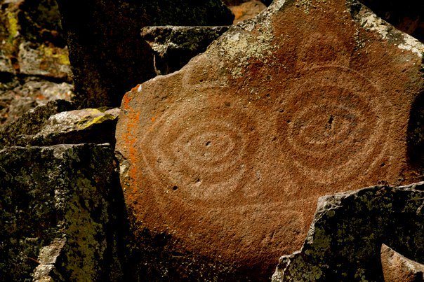
Tsagiglalal, or “She Who Watches,” pictograph in the Columbia River Gorge. Photo: Jeffrey St. Clair.

When the founders of the United States designed the Constitution, they were learning from history that democracy was likely to fail – to find someone who would fool the people into giving him complete power and then end the democracy.

They designed checks and balances to guard against the accumulation of power they had found when studying ancient Greece and Rome. But there were others in North America who had also seen the dangers of certain types of government and had designed their own checks and balances to guard against tyranny: the Native Americans.

Although most Americans today don’t know it, there were large centralized civilizations across much of North America in the 10th through 12th centuries. They built massive cities and grand irrigation projects across the continent. Twelfth-century Cahokia, on the banks of the Mississippi River, had a central city about the size of London at the time. The sprawling 12th-century civilization of the Huhugam had several cities of more than 10,000 people and a total population of perhaps 50,000 in the Southwestern desert.

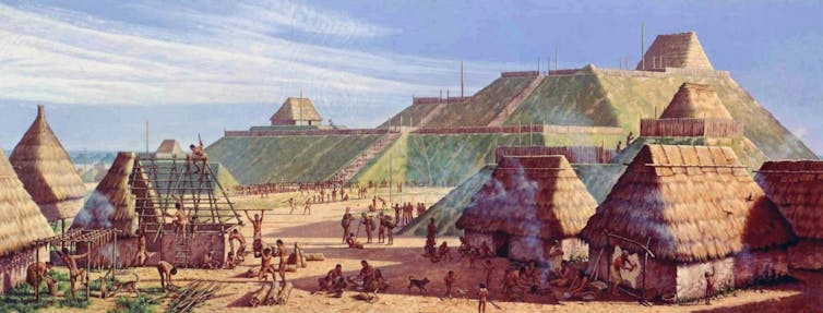
A painting shows people erecting wooden and thatch buildings against a backdrop of massive flat-topped mounds.
An artist’s depiction of life in Cahokia.
Michael Hampshire for the Cahokia Mounds State Historic Site via Wikimedia CommonsCC BY-SA

The ruins of these constructions remain, more than 1,000 years later, in places as far-flung as PhoenixSt. Louis and north Georgia.

The American Colonists and founders thought Native American societies were simple and primitive – but they were not. As research has found, including my own, and as I explain in my book, “Native Nations: A Millennium in North America,” Native American communities were elaborate consensus democracies, many of which had survived for generations because of careful attention to checking and balancing power.

Powerful rulers led many of these civilizations, combining political and religious power, much as monarchs of Europe in later centuries would claim a divine right to rule.

In the 13th century, though, a global cooling trend began, which has been called the Little Ice Age. In part because of that cooling, large-scale farming became more difficult, and these large civilizations struggled to feed their people. Elites began hoarding wealth. The people wanted change.

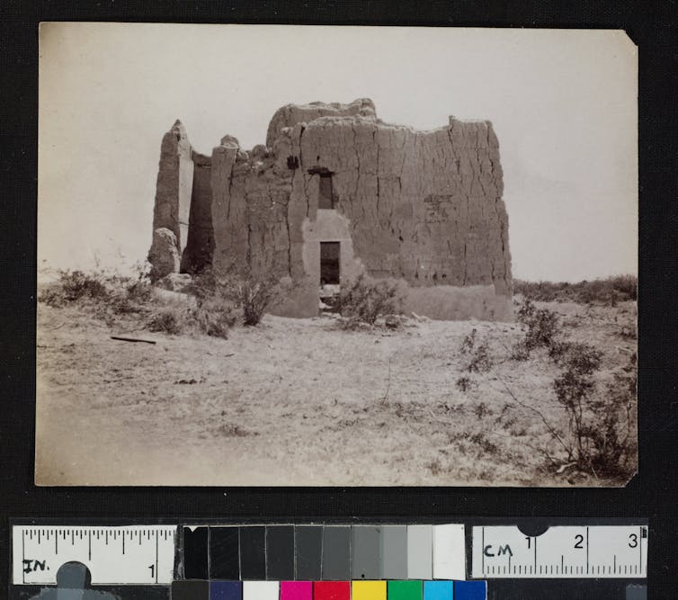
A massive adobe structure.
Casa Grande, an adobe castle that was home to the rulers of the Huhugam, as seen in 1892. photoCL 215 (112), Huntington Library

Spreading out

The residents of North America’s great cities responded to these stresses by reversing the centralization of power and wealth. Some revolted against their leaders. Others simply left the cities and spread out into smaller towns and farms. All across the continent, they built smaller, more democratic and more egalitarian societies.

Huge numbers left Cahokia’s realm entirely. They found places that still had game to hunt and woods full of trees for firewood and building, both of which had declined near Cahokia due to its rapid growth.

The population of the central city of Cahokia fell from perhaps 20,000 people to only 3,000 by 1275. At some point the elite left as well, and by the late 15th century the cities of Cahokia’s realm were completely gone.

Encouraging engaged democracy

As they formed these new and more dispersed societies, the people who had overthrown or fled the great cities and their too powerful leaders sought to avoid mesmerizing leaders who made tempting promises in difficult times. So they designed complex political structures to discourage centralization, hierarchy and inequality and encourage shared decision-making.

These societies intentionally created balanced power structures. For example, the oral history of the Osage Nation records that it once had one great chief who was a military leader, but its council of elder spiritual leaders, known as the “Little Old Men,” decided to balance that chief’s authority with that of another hereditary chief, who would be responsible for keeping peace.

Another way some societies balanced power was through family-based clans. Clans communicated and cooperated across multiple towns. They could work together to balance the power of town-based chiefs and councils.

An ideal of leadership

Many of these societies required convening all of the people – men, women and children – for major political, military, diplomatic and land-use decisions. Hundreds or even thousands might show up, depending on how momentous the decision was.

They strove for consensus, though they didn’t always achieve it. In some societies, it was customary for the losing side to quietly leave the meeting if they couldn’t bring themselves to agree with the others.

Leaders generally governed by facilitating decision-making in council meetings and public gatherings. They gave gifts to encourage cooperation. They heard disputes between neighbors over land and resources and helped to resolve them. Power and prestige came to lie not in amassing wealth but in assuring that the wealth was shared wisely. Leaders earned support in part by being good providers.

‘Calm deliberation’

The Native American democracy that the U.S. founders were most likely to know about was the Iroquois Confederacy. They call themselves the Haudenosaunee, the “people of the longhouse,” because the nations of the confederacy have to get along like multiple families in a longhouse.

In their carefully balanced system, women ran the clans, which were responsible for local decisions about land use and town planning. Men were the representatives of their clans and nations in the Haudenosaunee council, which made decisions for the confederacy as a whole. Each council member, called a royaner, was chosen by a clan mother.

The Haudenosaunee Great Law holds a royaner to a high standard: “The thickness of their skin shall be seven spans – which is to say that they shall be proof against anger, offensive actions and criticism. Their hearts shall be full of peace and good will.” In council, “all their words and actions shall be marked by calm deliberation.”

The law said the ideal royaner should always “look and listen for the welfare of the whole people and have always in view not only the present but also the coming generations, even those whose faces are yet beneath the surface of the ground – the unborn of the future Nation.”

Of course, people do not always live up to their values, but the laws and traditions of Native nations encouraged peaceful discussion and broad-mindedness. Many Europeans were struck by the difference. The French explorer La Salle in 1678 noted with admiration of the Haudenosaunee that “in important meetings, they discuss without raising their voices and without getting angry.”

Politicians, government officials and everyday Americans might find inspiration in the models of democracy created by Native Americans centuries ago. There was an additional ingredient to the political and social balance: Leaders looked ahead and sought to protect the well-being of every person, even those not yet born. The people, in exchange, had a responsibility to not enmesh their royaners in less serious matters, which the Haudenosaunee Great Law called “trivial affairs.”The Conversation

This article is republished from The Conversation under a Creative Commons license. Read the original article.

Kathleen DuVal is Professor of History at the University of North Carolina at Chapel Hill.


LA REVUE GAUCHE - Left Comment: Native America and the Evolution of Democracy