It’s possible that I shall make an ass of myself. But in that case one can always get out of it with a little dialectic. I have, of course, so worded my proposition as to be right either way (K.Marx, Letter to F.Engels on the Indian Mutiny)
Tuesday, December 05, 2023
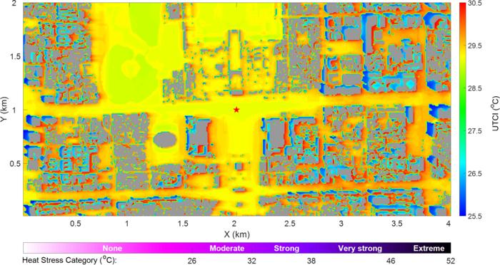
Real-time assessments of regional weather and human comfort index on 10-meter-resolution were provided over Tiananmen area, Beijing
HORIZONTAL DISTRIBUTION OF UNIVERSAL THERMAL CLIMATE INDEX IN ℃ AT 2-METER-OFF GROUND AT 10 A.M. JULY 1ST 2021, HIGHER VALUE INDICATES MORE HEAT STRESS.
This study is led by Dr. Xiaoran Guo and Dr. Chao Yan (both from Institute of Urban Meteorology, China Meteorological Administration). A fast urban micro-meteorology model was developed and applied over the central Beijing region in summer during a large outdoor event. In comparison with conventional weather forecast methods, the main feature of this model lies in the fine spacial structures of wind, air temperature, humidity and human comfort index revealed by the simulation, which is adequate to capture the shapes of local green belts, water surfaces and 3-D buildings. With these urban morphology resolved, their blockage effects on wind fields and sun lights are calculated as well as the evaporations over certain land type. To realize fast simulation, the wind fields around building cluster were constructed according to statistical relationships and empiracal parameterizations, which largely improve the computational efficiency comparing with traditional CFD methods. To quantify the comprehensive influences of weather and environment on human physiological process, universal thermal climate index was calculated and visualized as a main product for the weather service.
Taking the simulated horizontal distribution of human comfort index as an example, at 10 a.m. july 1st 2021, there were cool areas at the west sides of each building hidden in their shadows, while the east sides were generally under higher heat stress, partly due to the weak wind within building’s lee-side cavity zone. In contrast, through the evaporation processes, the hot stresses were considerably reduced by water surface while effectiveness of vegetation were limited. Through model verification, their results were generally in good agreement with measurements.
See the article:
Guo X, Yan C, Miao S. 2023. A rapid modeling method for urban microscale meteorology and its applications. Science China Earth Sciences, 66(10): 2224‒2238
(A) LATITUDINAL VARIABILITY IN THE TEMPERATURE RESPONSES TO LCCS (ΔTLCC) AND IN THE RATIOS OF ΔTLCC TO THE OVERALL TEMPERATURE VARIATION (ΔT) AT THE SAME LOCATION OVER THE SAME PERIOD; (B) SEASONAL ΔTLCC PATTERNS IN FOUR LATITUDE ZONES.
Land cover changes (LCCs) affect surface temperatures at local scale through biophysical processes. However, limited by the coarse spatial resolution of available data, past observation-based studies mainly focused on the potential effects of virtual afforestation/deforestation using the space-for-time assumption. Prof. Li and his team firstly generated a high-resolution temperature dataset, and then explored the actual effects of all types of realistic LCCs by adopting the space-and-time scheme and utilizing extensive satellite observations.
They identified a total of 529,128 1-km pixels experienced LCC from 2006 to 2015. The widely studied afforestations/deforestations accounted for 46.28%, whereas previously underexplored transitions within non-forest vegetation types and almost unnoticed changes involving non-vegetation types occurred with proportions of 18.62% and 35.10%, respectively, illustrating the necessity to explore the comprehensive influences of all LCC types instead of considering only the influences of forest changes, as has been done in previous research.
The average temperature in the areas with LCCs increased by 0.08 K globally, but varied significantly across latitudes, ranging from -0.05 K to 0.18 K. These effects accounted for up to 44.6% of overall concurrent warming, emphasizing the importance of LCC biophysical influences. By comparing the importance of different LCC processes within a unified framework, the researchers found that cropland expansions dominated cooling effects in the northern mid-latitudes, whereas forest-related LCCs caused warming effects elsewhere.
Unlike the symmetric assumption of potential effects, the researchers revealed obvious asymmetries in the actual effects: LCCs with warming effects occurred more frequently, with stronger intensities, than LCCs with cooling effects. Even for the mutual changes between two covers in the same region, warming LCCs generally had larger magnitudes than their cooling counterparts. Attribution analysis indicated that the asymmetric temperature effects was caused by a combination of asymmetric changes in transition fractions and driving variables. These findings demonstrated that the increase in temperature resulting from a specific LCC cannot be counteracted by simply performing its reverse LCC of the same area during the same period, providing a new perspective on the land management and climate adaptation policies.
INSTITUTE OF ATMOSPHERIC PHYSICS, CHINESE ACADEMY OF SCIENCES
IMAGE:
DIAGRAM DEPICTING THE TWO MAIN PROCESSES FOR QUASI-LINEAR SURFACE TEMPERATURE AND OUTGOING LONGWAVE RADIATION (OLR). LEFT: ENHANCEMENT OF MERIDIONAL SURFACE TEMPERATURE GRADIENT BY THE GREENHOUSE EFFECT OF WATER VAPOR; RIGHT: RE-ROUTING PART OF OLR FROM WARM PLACES TO COLD PLACES BY POLEWARD ENERGY TRANSPORT.
Curious about what drives Earth's climate sensitivity? A recent study in Advances in Atmospheric Sciences explores the complex links transforming the relationship between surface temperature and outgoing longwave radiation (OLR) from quartic to quasi-linear. Led by Dr. Jie Sun from Florida State University, this research unravels hidden mechanisms shaping our planet's climate, providing fresh insights into why the temperature and OLR relation deviates from the quartic pattern stated by the Stefan-Boltzmann law.
What is the Stefan-Boltzmann law? Greenhouse gases in the atmosphere create a contrast between surface thermal emission, linked to the fourth power of surface temperature, and OLR.
Prof. Xiaoming Hu from Sun Yat-sen University, the corresponding author of the study, explained, "Vertical convective energy transport acts like an atmospheric mixer, swirling temperatures within a column. This allows the relation between surface temperature and OLR to still follow the quartic pattern by lowering the radiative emission layer."
The study uncovers how various factors influence surface temperature and OLR. The greenhouse effect of water vapor acts as a magnifier, amplifying temperature differences across Earth's surface without altering the latitudinal variation of OLR. This suppresses the nonlinearity between OLR and surface temperature.
Poleward energy transport, on the other hand, functions as equalizers, harmonizing temperature disparities across different regions of the globe. One of the by-products of this global heat redistribution is the re-routing of OLR from warm places to cold places, acting to reduce OLR difference across different regions. This, in turn, further suppresses the nonlinearity.
Prof. Ming Cai from Florida State University highlighted, "Understanding these complex climate interactions is akin to decoding a puzzle. Each piece brings us closer to deciphering our planet's climate intricacies."
By illuminating these connections, scientists make significant strides in comprehending Earth's climate and how its intricate components orchestrate the overall climate sensitivity, namely not only energy output rate but also where the output takes place.
A Quasi-Linear Relationship between Planetary Outgoing Longwave Radiation and Surface Temperature in a Radiative-Convective-Transportive Climate Model of a Gray Atmosphere
No comments:
Post a Comment