M7.8 Philippines earthquake triggers tsunami warning across Asia
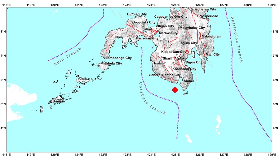
A magnitude-7.8 earthquake hit off Sarangani early on June 8, destroying buildings, disrupting utility services across parts of Mindanao, and forcing the suspension of classes and government work, Inquirer reports. The tectonic tremor struck at 7:37 am at a depth of 33 km, with its epicentre located 32 km south of Maasim.
The disaster highlights the extreme vulnerability of the southern Philippines to the Pacific Ring of Fire – where high-magnitude underwater quakes pose a dual threat of severe localized destruction and wider regional tsunami risks that can disrupt multiple Southeast Asian nations simultaneously. The timing is particularly damaging, paralysing the region on the official opening day of the school year.
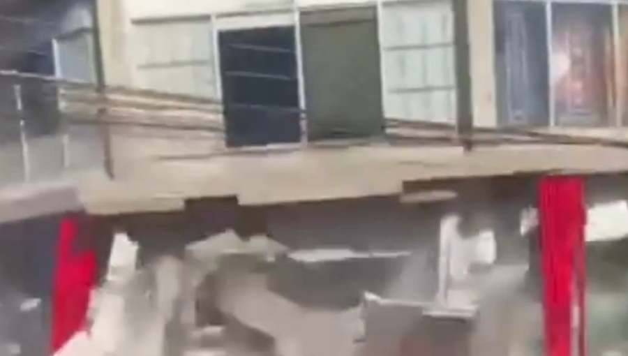
According to Aljazeera, footage on official social media channels showed a three-storey building housing a Jollibee restaurant collapsing in a cloud of debris in General Santos City. Other structures suffered smashed windows and caved-in roofs. The initial shock lasted roughly 30 seconds in Koronadal City, severing internet, electricity, and water networks. A magnitude aftershock followed shortly after at 7:49 am.
The Philippine Institute of Volcanology and Seismology (PHIVOLCS) registered the highest shaking at Instrumental Intensity VIII in Malapatan, Sarangani. General Santos City experienced Intensity VII, whilst Intensity VI hit Palimbang and Senator Ninoy Aquino. Intensity V shaking reached Davao City, Kidapawan City, Carmen, Bagumbayan, Kalamansig, President Quirino, Sibuco, and Siocon. Instrumental Intensity VII was also recorded in Koronadal City and Santa Maria.
The threat extended to regional waters. The Pacific Tsunami Warning Centre warned that coastal areas in the Philippines could face waves reaching up to 3 metres. Ocean swells of up to 1 metre were deemed possible along shorelines in Malaysia and Indonesia, prompting coastal safety alerts across the Philippines, Indonesia, and Japan.
President Ferdinand Marcos activated national crisis institutions, including the Office of Civil Defence and the National Disaster Risk Reduction and Management Council, on June 8. The premier urged immediate coastal evacuations to higher ground. Concurrently, Phivolcs instructed maritime operators to secure vessels away from the waterfront or remain in deep water offshore. No casualties have been confirmed whilst the evaluation of the disaster zone continues.
At least 15 people have been killed and another 129 have been injured after a magnitude-7.8 earthquake hit the southern Philippines and northeast Indonesia early on June 8.
The quake hit at 7:37am local time off the coast of General Santos City on Mindanao, the Philippines' largest southern island. The Philippine Institute of Volcanology and Seismology has since said the earthquake occurred at a depth of 10km.
According to the BBC, officials from the Philippine Office of Civil Defense said 12 of the deaths were recorded in the Soccsksargen region, which includes South Cotabato, Sultan Kudarat, Sarangani and General Santos City. Rodrigo Sosmeña, director of the local civil defence office, said at least 129 people were injured in the same region.
More than two dozen buildings, many of them commercial properties, were damaged by the earthquake. Images from General Santos City showed several collapsed structures, including a damaged supermarket and a branch of fast-food chain Jollibee.
Several countries across the region, including the Philippines, Indonesia and Japan, issued tsunami warnings following the quake, although most have since been lifted.
President Ferdinand Marcos Jr said he had directed all relevant government agencies to respond immediately, the BBC added, and urged residents in affected areas to move to higher ground.
7.8 magnitude earthquake rocks the Philippines, triggering tsunami warnings across region
The strongest earthquake to hit the Philippines this year was centered at sea and caused damage in a key coastal city, knocking down power and setting off 1-metre tsunami waves along nearby coasts, officials said.
A 7.8-magnitude earthquake struck the southern Philippines on Monday, killing at least 19 people, collapsing buildings, and sparking tsunami warnings across the region.
Authorities in the Philippines and Indonesia urged residents in affected coastal regions to move to higher ground immediately, after the offshore quake hit about 24 kilometres west of Mindanao island's Sarangani province, the United States Geological Survey said.
The earthquake caused the collapse of at least one building in General Santos, a tuna-processing city of more than 700,000 people that is also a commercial hub in the south.
"As of now, there is one reported death and four injured. This is only an initial report," said Master Sergeant Robert Dagon of the General Santos City police.
"Many buildings were affected, but I cannot enumerate them now because we are busy with ongoing rescues," he added.
Videos posted to social media showed a shopping centre with a Jollibee fast food restaurant reduced to rubble in General Santos, while a school building that officials said was unoccupied crumpled in another city.
Philippine President Ferdinand Marcos suspended school classes in affected areas of Mindanao while calling on residents in coastal areas to evacuate immediately.
"Move to higher ground now. Do not wait," he said. "Your life is more important than anything left behind."
Tsunami warnings triggered
The powerful earthquake triggered tsunami warnings across several countries in the Pacific.
The Philippine Institute of Volcanology and Seismology monitored 1-metre waves in the provinces of Sultan Kudarat and Sarangani, and the Pacific Tsunami Warning Center (PTWC) said tsunami waves up to 3 metres were possible on some coasts of the Philippines.
The PTWC also said in a notice that tsunami waves were possible "within the next three hours" along the coasts of the Philippines, Indonesia, Palau, Taiwan and Papua New Guinea.

Indonesia's national disaster agency, meanwhile, instructed officials in the North Sulawesi capital, Manado, northern Gorontalo province and the Sangihe islands "to immediately direct their residents to evacuate in an orderly manner to higher ground".
Japanese authorities separately issued a tsunami advisory for swathes of its Pacific coast, projecting waves of up to one metre to hit different regions from 11:30am local time.
Malaysia’s Meteorological Department issued a tsunami warning for Sabah state on Borneo island and smaller sea changes were possible in Taiwan, Japan, Papua New Guinea and several island nations and territories in the western Pacific. An advisory for Guam was lifted about two hours after the quake and there was no threat to Hawaii, the PTWC said.
The strongest earthquake to hit the Philippines this year was was centered at sea about 13 kilometers (8 miles) southwest of General Santos and was caused by movement in the Cotabato Trench at a depth of 10 kilometers (6.2 miles), according to the Philippine Institute of Volcanology and Seismology.

Aftershocks up to 6.5 magnitude followed, the U.S. Geological Survey said. It measured the original quake at 55 kilometers (34 miles) deep. Variations in measurements by different agencies are common in the immediate aftermath of an earthquake.
Earthquakes are a near-daily occurrence in the Philippines, which is situated on the Pacific "Ring of Fire", an arc of intense seismic activity stretching from Japan through Southeast Asia and across the Pacific basin.
Eastern Mindanao was rocked by a pair of earthquakes of 7.4 and 6.7 magnitude in October that killed at least eight people.
No comments:
Post a Comment