Scientists map radioactive soil in Western Europe
For the new map, scientists were able to differentiate between radionuclides released by military tests and radionuclides released by the Chernobyl accident. Photo by Katrin Meusburger, et al. / Scientific Reports
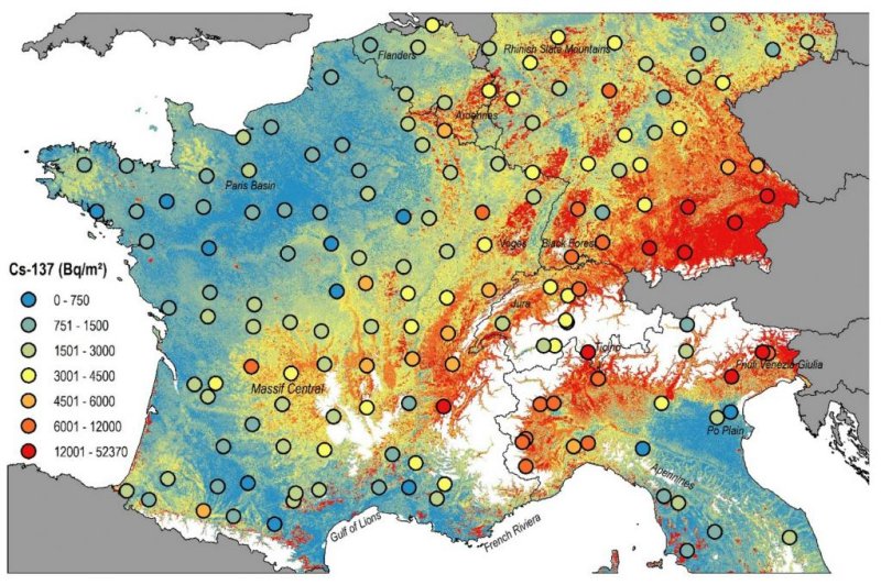
July 16 (UPI) -- Using old data and a new measurement technique, scientists have mapped radioactive soil contamination in Switzerland and several surrounding countries.
Researchers used a new analysis method to calculate caesium and plutonium concentrations in an archive of European soil samples. The team published their new map on Thursday in the journal Scientific Reports.
Over the last half-century, particularly during the 1960s, the two radionuclides were released during dozens of military nuclear tests. Caesium was also released by the Chernobyl accident in 1986.
"We have created a new map to provide a basis for estimating the soil loss since the anthropogenic release of radionuclides," first study author Katrin Meusburger, researcher with the group Environmental Geoscience at the University of Basel, said in a news release. "To do this, it is important to know the proportion of radioactive fallout from Chernobyl."
RELATED 75 years ago, 'Trinity' test ushered in nuclear age, changed the world
In addition to revealing the long-term effects of nuclear fallout, the new map can also help researchers analyze soil erosion rates since the 1960s.
The soil archive used by scientists featured samples collected from beneath grassland, land that has remained stable over the last several decades.
The new analysis method allowed researchers to differentiate between the radionuclides caused by military testing and the caesium released into the environment by the Chernobyl fallout.
RELATED Cold War nuclear bomb tests help scientists measure age of whale sharks
"Unlike with the previous map, we can now distinguish between the sources of nuclear fallout," said Meusburger.
The new map suggests caesium released during the nuclear tests spread out across the atmosphere's upper layers before being carried to the ground by rain. The nuclear tests-derived caesium is relatively evenly distributed in European soils, though it is found in slightly greater concentrations across wetter regions, including Massif Central, the Ardennes and Brittany.
Because the caesium released by the Chernobyl accident failed to reach such high altitudes, remaining in the tropospheric level, its footprint is much smaller. Rains quickly brought the Chernobyl caesium back to the ground, contaminating only the soil beneath the plume that circled Ukraine in the aftermath of the explosion.
RELATED Arctic climate change: Recent carbon emissions worse than ancient methane
The mapping effort revealed higher Chernobyl caesium concentrations in Alsace, Franche-Comté and the foothills of the Alps, northern Italy and southern Germany.
No comments:
Post a Comment