Crews struggle to stop fire bearing down on Lake Tahoe
1 of 18
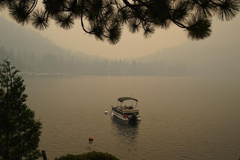
Smoke from the Caldor Fire, shrouds Fallen Leaf Lake near South Lake Tahoe, Calif., Tuesday, Aug. 24, 2021. The massive wildfire, that is over a week old, has scorched more than 190 square miles, (492 square kilometers) and destroyed hundreds of homes since Aug. 14. It is now less than 20 miles from Lake Tahoe. (AP Photo/Rich Pedroncelli)
1 of 18
Smoke from the Caldor Fire, shrouds Fallen Leaf Lake near South Lake Tahoe, Calif., Tuesday, Aug. 24, 2021. The massive wildfire, that is over a week old, has scorched more than 190 square miles, (492 square kilometers) and destroyed hundreds of homes since Aug. 14. It is now less than 20 miles from Lake Tahoe. (AP Photo/Rich Pedroncelli)
SOUTH LAKE TAHOE, Calif. (AP) — A Northern California fire that gutted hundreds of homes advanced toward Lake Tahoe on Wednesday as thousands of firefighters tried to box in the flames, and a thick yellow haze of the nation’s worst air enveloped tourists.
In Southern California, at least a dozen homes and outbuildings were damaged or destroyed after a fire broke out Wednesday afternoon and quickly ran through tinder-dry brush in mountains northeast of Los Angeles. Evacuations were ordered for about 1,000 people.
Crews mounted an air attack to keep the South Fire from the tiny communities of Lytle Creek and Scotland near the Cajon Pass in San Bernardino County. By nightfall, the fire appeared to be mostly contained.
To the north, a new fire erupted in the Sierra Nevada foothills and quickly burned at least 1,000 acres of land near New Melones Lake in Calaveras County, prompting evacuations.
Meanwhile, the Caldor Fire spread to within 20 miles (32 kilometers) southwest of Lake Tahoe, eating its way through rugged timberlands and “knocking on the door” of the basin that straddles the California-Nevada state line, California’s state fire chief Thom Porter warned this week.
Ash rained down and tourists ducked into cafes, outdoor gear shops and casinos on Lake Tahoe Boulevard for a respite from the unhealthy air.
South Lake Tahoe and Tahoe City on the west shore had the nation’s worst air pollution at midmorning Wednesday, reaching 334, in the “hazardous” category of the 0-500 Air Quality Index, according to AirNow, a partnership of federal, state and local air agencies.
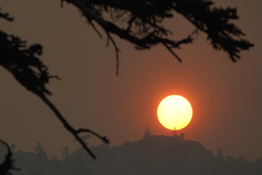
South of Tahoe, Rick Nelson and his wife, Diane, had planned to host a weekend wedding at Fallen Leaf Lake, where his daughter and her fiance had met. However, the smoke caused most of the community to leave. The sun was an eerie blood orange, and the floats and boats in the lake were obscured by haze Tuesday.
In the end, the Nelsons spent two days arranging to have the wedding moved from the glacial lake several hours southwest to the San Francisco Bay Area.
“Everybody’s trying to make accommodations for the smoke. And I think it’s becoming a reality for us, unfortunately,” Diane Nelson said. “I just think that the smoke and the fires have gotten bigger, hotter and faster-moving.”
Climate change has made the West warmer and drier in the past 30 years and will continue to make the weather more extreme and wildfires more destructive, according to scientists.
Although there were no evacuations ordered for Lake Tahoe, it was impossible to ignore a blanket of haze so thick and vast that it closed schools for two days in Reno, Nevada, which is about 60 miles (100 kilometers) from the fire.
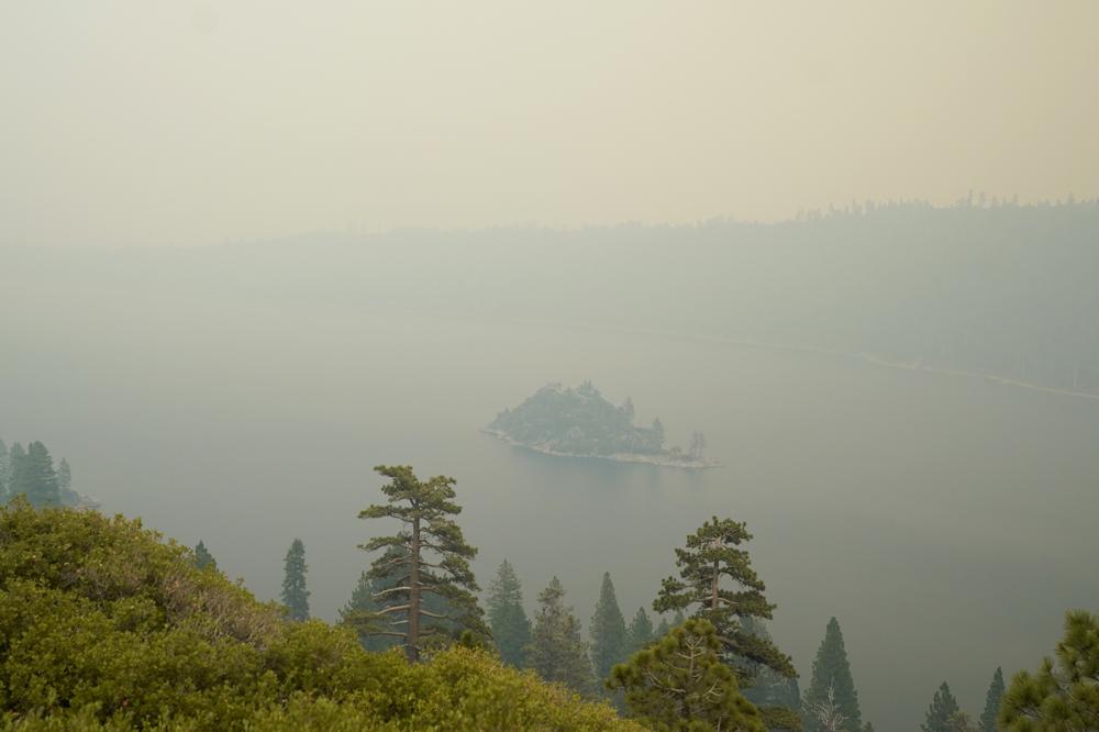
Lake Tahoe's Emerald Bay is shrouded in smoke from the Caldor Fire, near South Lake Tahoe, Calif., Tuesday, Aug. 24, 2021. The massive wildfire, that is over a week old, has scorched more than 190 square miles, (492 square kilometers) and destroyed hundreds of homes since Aug. 14. It is now less than 20 miles from Lake Tahoe.
(AP Photo/Rich Pedroncelli)
The school district that includes Reno reopened most schools on Wednesday, citing improved air quality conditions. However, the Washoe County School District’s schools in Incline Village on the north shore of Lake Tahoe remained closed, the district said in a statement.
The Caldor fire has scorched more than 197 square miles (510 square kilometers) and destroyed at least 461 homes since Aug. 14 in the Sierra Nevada southwest of the lake. It was 11% contained and threatened more than 17,000 structures.
The western side of the blaze continued to threaten more than a dozen small communities and wineries. On the fire’s eastern side, crews bulldozed fire lines, opened up narrow logging roads and cleared ridgetops in hopes of stopping its advance, fire officials said.
More than 2,500 firefighters were on the line and more resources were streaming in, including big firefighting aircraft, fire officials said.
Meanwhile, California’s Dixie Fire, the second-largest in state history at 1,148 square miles (2,973 square kilometers), was burning only about 65 miles (104 kilometers) to the north. New evacuations were ordered after winds pushed the blaze to the northeast on Wednesday, as flames crossed State Route 44 and headed toward campgrounds near Eagle Lake.
The Dixie Fire, which broke out July 13, was 43% contained. At least 682 homes were among more than 1,270 buildings that have been destroyed.
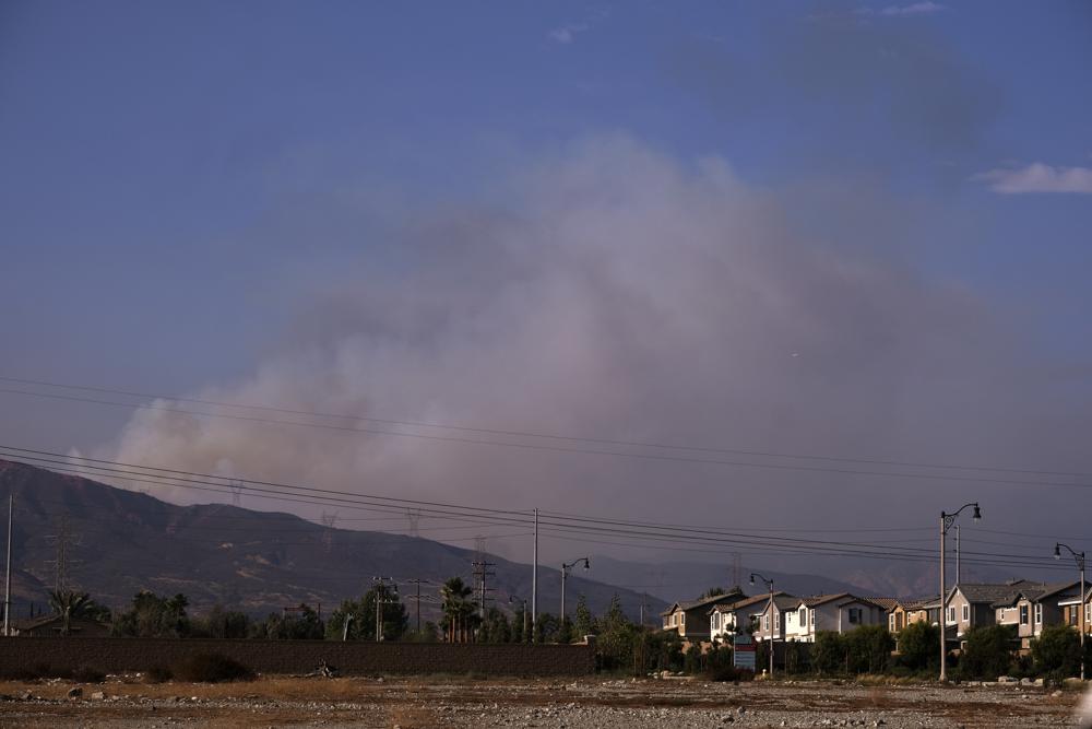
Smoke rises from the mountains as the South fire burns in San Bernardino County north of Rialto, Calif., seen from Fontana, Calif., Wednesday, Aug. 25, 2021. In Southern California, an unknown number of remote homes and outbuildings burned after a fire broke out Wednesday afternoon and quickly ran through tinder-dry brush in mountains northeast of Los Angeles. Evacuations were ordered, and crews mounted an air attack to keep the South Fire from the tiny communities of Lytle Creek and Scotland near the Cajon Pass in San Bernardino County. (AP Photo/Ringo Chiu)
In the southern Sierra Nevada, there was growing concern after the French Fire expanded near Lake Isabella, a popular fishing and boating destination.
“The fire really made a big push and put up a huge column of smoke,” fire spokesman Alex Olow said Wednesday. Because flames were still active, assessment teams have been unable to get into neighborhoods to see if any homes were damaged, he said.
About 10 communities were under evacuation orders. The fire has blackened 32 square miles (83 square kilometers) since Aug. 18.
Nationally, 92 large fires were burning in a dozen mainly Western states, according to the National Interagency Fire Center in Boise, Idaho.
Northern California has experienced a series of disastrous blazes that have burned hundreds of homes, and many remain uncontained.
On Tuesday, President Joe Biden declared that a major disaster exists in California and ordered federal aid made available to local governments, agencies and fire victims in four northern counties ravaged by blazes dating back to July 14.
California wildfire dangers may be spreading south
By CHRISTOPHER WEBER and JOHN ANTCZAK
1 of 22
LOS ANGELES (AP) — A wildfire that burned several homes near Los Angeles may signal that the region is facing the same dangers that have scorched Northern California.
The fire in San Bernardino County erupted Wednesday afternoon, quickly burned several hundred acres and damaged or destroyed at least a dozen homes and outbuildings in the foothills northeast of LA, fire officials said. Crews used shovels and bulldozers and mounted an air attack to keep the South Fire from the tiny communities of Lytle Creek and Scotland near the Cajon Pass.
Some 600 homes and other buildings were threatened along with power transmission lines, and 1,000 residents were under evacuation orders.
By nightfall, firefighters appeared to have gained the upper hand and few flames were to be seen. But the blaze was worrying because Southern California’s high fire season is typically later in the year when strong, dry Santa Ana winds blast out of the interior and flow toward the coast.


After a few cooler days, the southern region was expected to see a return of hot weather heading into the weekend. In addition to dangerously dry conditions, the region is faced with firefighting staffing that is increasingly stretched thin, said Lyn Sieliet, spokeswoman for the San Bernardino National Forest.
“Some of our firefighters that we normally have on our forests are working on fires in Northern California, or Idaho and Washington,” she told KTLA-TV. “We don’t have the full staff that we normally do.”
The largest fires in the state and in the nation were in Northern California, where they have burned down small mountain towns and destroyed huge swaths of tinder-dry forest.
The Caldor Fire destroyed some 500 homes since Aug. 14 in the Sierra Nevada southwest of Lake Tahoe, including much of the tiny hamlet of Grizzly Flats. It was 12% contained and threatened more than 17,000 structures.
Buck Minitch, a firefighter with the Pioneer Fire Protection District, was called to the fire lines last week while his wife fled their Grizzly Flats home with their two daughters, three dogs, a kitten and duffel bag of clothes, the San Jose Mercury News reported.
Hannah Minitch evacuated to her parents’ property and the next morning received a text from her husband showing only a chimney where their house once stood. The two briefly wept together during a telephone call before he got back to work.
“‘We’ve got nothing left here,’” she recalled him saying. “‘I’ve got to go protect what’s left for other people.’”
At times the wind-driven fire was burning 1,000 acres of land per hour and on Wednesday it was less than two dozen miles from Lake Tahoe, an alpine vacation and tourist spot that straddles the California-Nevada state line.

There weren’t any evacuations in Tahoe but the fire continued to cast a sickly yellow pall of smoke over the scenic region.
South Lake Tahoe and Tahoe City on the west shore had the nation’s worst air pollution at midmorning Wednesday, according to AirNow, a partnership of federal, state and local air agencies.
Meanwhile, California’s Dixie Fire, the second-largest in state history at 1,160 square miles (3,004 square kilometers), was burning only about 65 miles (104 kilometers) to the north. It was 45% contained. Some 700 homes were among nearly 1,300 buildings that have been destroyed.
In the southern Sierra Nevada, there was growing concern as the French Fire expanded near Lake Isabella, a popular fishing and boating destination. About 10 communities were under evacuation orders. The fire has blackened 32 square miles (83 square kilometers) since Aug. 18.
Smoke from the fires had fouled air farther south. The South Coast Air Quality Management District issued an advisory through Thursday morning for large portions of Los Angeles, Riverside and San Bernardino counties.
Nationally, 92 large fires were burning in 13 mainly Western states, according to the National Interagency Fire Center in Boise, Idaho.
Climate change has made the West warmer and drier in the past 30 years and will continue to make the weather more extreme and wildfires more destructive, according to scientists.
By CHRISTOPHER WEBER and JOHN ANTCZAK
1 of 22
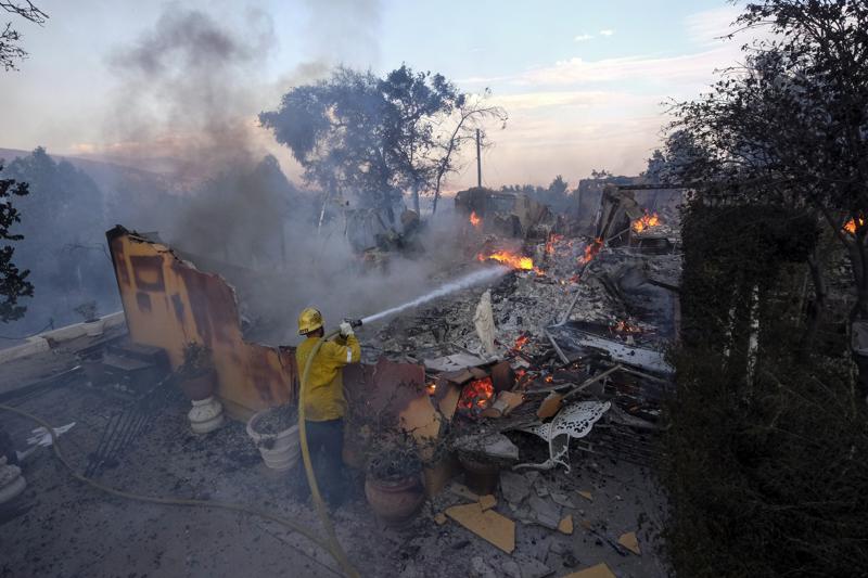
A firefighter tries to extinguish the flames at a burning house as the South Fire burns in Lytle Creek, San Bernardino County, north of Rialto, Calif., Wednesday, Aug. 25, 2021. (AP Photo/Ringo H.W. Chiu)
LOS ANGELES (AP) — A wildfire that burned several homes near Los Angeles may signal that the region is facing the same dangers that have scorched Northern California.
The fire in San Bernardino County erupted Wednesday afternoon, quickly burned several hundred acres and damaged or destroyed at least a dozen homes and outbuildings in the foothills northeast of LA, fire officials said. Crews used shovels and bulldozers and mounted an air attack to keep the South Fire from the tiny communities of Lytle Creek and Scotland near the Cajon Pass.
Some 600 homes and other buildings were threatened along with power transmission lines, and 1,000 residents were under evacuation orders.
By nightfall, firefighters appeared to have gained the upper hand and few flames were to be seen. But the blaze was worrying because Southern California’s high fire season is typically later in the year when strong, dry Santa Ana winds blast out of the interior and flow toward the coast.


“Some of our firefighters that we normally have on our forests are working on fires in Northern California, or Idaho and Washington,” she told KTLA-TV. “We don’t have the full staff that we normally do.”
The largest fires in the state and in the nation were in Northern California, where they have burned down small mountain towns and destroyed huge swaths of tinder-dry forest.
The Caldor Fire destroyed some 500 homes since Aug. 14 in the Sierra Nevada southwest of Lake Tahoe, including much of the tiny hamlet of Grizzly Flats. It was 12% contained and threatened more than 17,000 structures.
Buck Minitch, a firefighter with the Pioneer Fire Protection District, was called to the fire lines last week while his wife fled their Grizzly Flats home with their two daughters, three dogs, a kitten and duffel bag of clothes, the San Jose Mercury News reported.
Hannah Minitch evacuated to her parents’ property and the next morning received a text from her husband showing only a chimney where their house once stood. The two briefly wept together during a telephone call before he got back to work.
“‘We’ve got nothing left here,’” she recalled him saying. “‘I’ve got to go protect what’s left for other people.’”
At times the wind-driven fire was burning 1,000 acres of land per hour and on Wednesday it was less than two dozen miles from Lake Tahoe, an alpine vacation and tourist spot that straddles the California-Nevada state line.

There weren’t any evacuations in Tahoe but the fire continued to cast a sickly yellow pall of smoke over the scenic region.
South Lake Tahoe and Tahoe City on the west shore had the nation’s worst air pollution at midmorning Wednesday, according to AirNow, a partnership of federal, state and local air agencies.
Meanwhile, California’s Dixie Fire, the second-largest in state history at 1,160 square miles (3,004 square kilometers), was burning only about 65 miles (104 kilometers) to the north. It was 45% contained. Some 700 homes were among nearly 1,300 buildings that have been destroyed.
In the southern Sierra Nevada, there was growing concern as the French Fire expanded near Lake Isabella, a popular fishing and boating destination. About 10 communities were under evacuation orders. The fire has blackened 32 square miles (83 square kilometers) since Aug. 18.
Smoke from the fires had fouled air farther south. The South Coast Air Quality Management District issued an advisory through Thursday morning for large portions of Los Angeles, Riverside and San Bernardino counties.
Nationally, 92 large fires were burning in 13 mainly Western states, according to the National Interagency Fire Center in Boise, Idaho.
Climate change has made the West warmer and drier in the past 30 years and will continue to make the weather more extreme and wildfires more destructive, according to scientists.
Gaps in wildfire smoke warning network leave people exposed
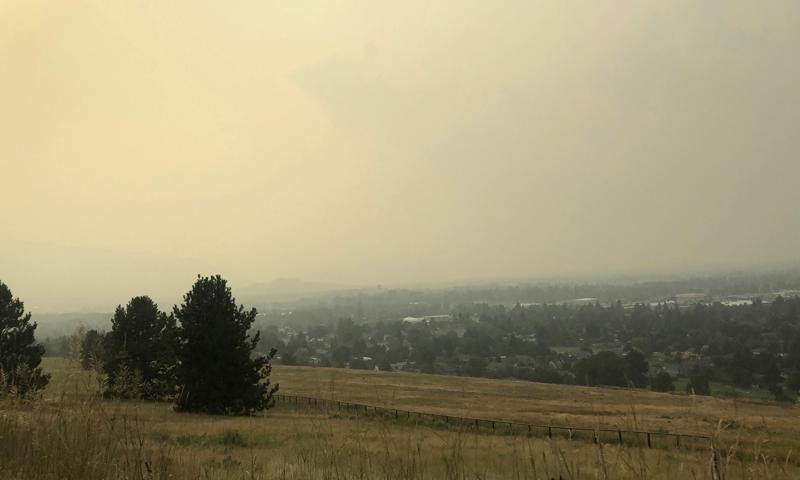
Smoke that has traveled from wildfires in Montana and the Western U.S., covers the Missoula Valley on Tuesday, Aug. 3, 2021, obscuring visibility and creating unhealthy air quality in Missoula, Mont.
By MATTHEW BROWN and PADMANANDA RAMA
1 of 5
1 of 5
Smoke that has traveled from wildfires in Montana and the Western U.S., covers the Missoula Valley on Tuesday, Aug. 3, 2021, obscuring visibility and creating unhealthy air quality in Missoula, Mont.
(AP Photo/Padmananda Rama)
BILLINGS, Mont. (AP) — Huge gaps between air quality sensors in the western U.S. have created blind spots in the warning system for wildfire smoke plumes sweeping North America this summer, amid growing concern over potential health impacts to millions of people exposed to the pollution.
Government programs to alert the public when smoke pollution becomes unhealthy rely on about 950 permanent monitoring stations and dozens of mobile units that can be deployed around major fires.
Those stations are heavily concentrated around major cities on the West Coast and east of the Mississippi River — a patchwork that leaves some people unable to determine local risks from smoke, including in rural areas where air quality can quickly degrade when fires ignite nearby. The problem persists far beyond fire lines because wildfire smoke travels for thousands of miles and loses its tell-tale odor yet remains a danger to public health.
The monitoring gaps underscore what officials and public health experts say is a glaring shortage of resources for a type of pollution growing worse as climate change brings increasingly long and destructive wildfire seasons to the U.S. West, southern Europe and eastern Russia.
Microscopic particles in wildfire smoke can cause breathing issues and more serious problems for people with chronic health conditions. Long-term effects remain under study but some researchers estimate chronic smoke exposure causes about 20,000 premature deaths a year in the U.S.
“It’s a very frustrating place to be where we have recurring health emergencies without sufficient means of responding to them,” said Sarah Coefield, an air quality specialist for the city of Missoula, Montana. “You can be in your office just breathing smoke and thinking you’re OK because you’re inside, but you’re not.”
Missoula, perched along the Clark Fork River with about 75,000 people, is surrounded by mountains and has become notorious as a smoke trap. All across the region are similar mountain valleys, many without pollution monitors, and smoke conditions can vary greatly from one valley to the next.
Montana has 19 permanent monitoring stations. That’s about one for every 7,700 square miles (20,000 square kilometers) or an area almost as big as New Jersey. New Jersey has 30.
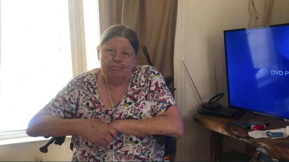
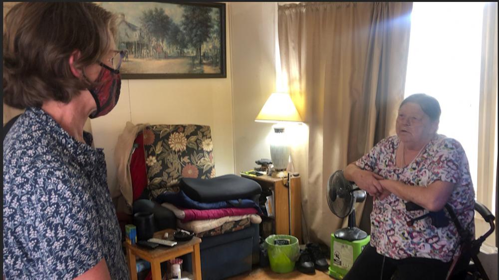
THURSDAY, AUG. 12, 2021 - Maureen Fogarty poses for a photo in her home on Thursday, Aug. 12, 2021, in Missoula, Mont. Fogarty, who has lung cancer and suffers from breathing problems, breathes with the aid of oxygen and air filters provided by Climate Smart, a small non-profit group founded to bring attention to global warming and help residents adapt to changes in climate. (AP Photo/Padmananda Rama)
Data on air quality is particularly sparse in eastern Montana, where smoke from a 266-square-mile (690-square-kilometer) fire on the Northern Cheyenne Indian Reservation got so bad this month that officials closed a health clinic when air filters couldn’t keep up with the pollution.
The smoke prompted tribal authorities to shield elders and others who were at risk by extending an evacuation order for Lame Deer, a town of about 2,000 people that sits beneath fire-scarred Badger Peak and is home to the tribal government complex.
But on the same day, Lame Deer and surrounding areas were left out of a pollution alert from state officials, who said extremely high smoke particle levels made the air unhealthy across large areas of Montana and advised people to avoid prolonged exertion to protect their lungs. A pollution sensor on the reservation had burned in the fire, and the nearest state Department of Environmental Quality monitor, about 30 miles (48 kilometers) away, showed an air quality reading of “good.”
That left tribal officials to judge the pollution hazard based on how far they could see — a crude fallback for areas without monitors. On a scale of one to 20, “I would say the smoke was a 19,” tribal spokesperson Angel Becker said.
“What makes it difficult is that Lame Deer is sitting in between a couple of ravines,” she added. “So when you get socked in (with smoke), it just sits here and that’s not good for elders or kids that have asthma or any breathing issues.”
Doug Kuenzli, who supervises Montana’s air quality monitoring program, said regulators recognize the need for more data on smoke but high-grade monitors can be prohibitively expensive — $10,000 to $28,000 each.
Oregon expanded its network over the past two years with five new monitors along the state’s picturesque coastline where smoke only recently became a recurring problem, said Tom Roick with the Oregon Department of Environmental Quality.
“We’re seeing more prevalence of wildfire smoke and increased intensity,” Roick said. “It’s not because we have more monitoring; it’s getting worse.”
Throughout the West, public health officials have struggled to get the message about dangers of smoke to at-risk communities, such as migrant workers who spend lots of time outdoors, people in houses without air filters and the elderly. Children, too, are more at risk of health problems.
That’s no small subset of society: People over 65 and children under 18 make up 40% of the population, said Kaitlyn Kelly, a wildfire smoke pollution specialist with the Washington Department of Health.
Rapid technological advancements mean households can buy their own monitoring equipment for around $250. The equipment is not as reliable as government stations, officials said, but the data from many of the privately-owned sensors is now displayed on an interactive smoke exposure map by the U.S. Environmental Protection Agency and Forest Service.
Although inaccurate readings have been reported for some consumer-grade sensors, officials said they can help fill blind spots in the government’s network. The number in use is fast increasing — from about 6,000 private sensors last year to more than 10,000 currently, according to EPA.
“There’s still gaps,” said Kelly. “The low-cost sensors are the first step in filling in the gaps where we don’t have (government) monitors.”
In Missoula, a small non-profit group founded to bring attention to global warming is going beyond warning people about smoke. It’s providing makeshift air filters and portable air cleaners to the homebound elderly and impoverished households.
Vinette Rupp, a 74-year-old Missoula woman who received a portable air cleaner, said she “can almost taste it” when the smoke gets thick in town. Neighbor Maureen Fogarty, 67, who has lung cancer and suffers from breathing problems, said her coughing has eased since she got one of the filters.
“Well it’s a lifesaver because I can breathe easier now,” Fogarty said. “The way it is, you know, you’ve got to come and go and you’re bringing in the unhealthy air, and it’s gonna affect you.”
Climate Smart Missoula, which provided the portable air cleaner, also makes and distributes filters through a local food bank. Costing about $30 apiece — versus $150 or more for a manufactured unit — the do-it-yourself purifiers are endorsed by public health officials. They’re crafted from box fans with high-efficiency furnace filters duct-taped to the back to trap pollution particles as air passes through.
Climate Smart Missoula director Amy Cilimburg said she and a colleague have built roughly 200 of them, paid for largely with donations.
“Our strategies for dealing with wildfire smoke were pray for rain, or leave town, or suffer — and that seemed inadequate,” Cilimburg said “It’s kind of caught up with us, even though scientists have told us it’s coming. I felt like we needed to get to work.”
—-
Follow Matthew Brown on Twitter: @MatthewBrownAP
BILLINGS, Mont. (AP) — Huge gaps between air quality sensors in the western U.S. have created blind spots in the warning system for wildfire smoke plumes sweeping North America this summer, amid growing concern over potential health impacts to millions of people exposed to the pollution.
Government programs to alert the public when smoke pollution becomes unhealthy rely on about 950 permanent monitoring stations and dozens of mobile units that can be deployed around major fires.
Those stations are heavily concentrated around major cities on the West Coast and east of the Mississippi River — a patchwork that leaves some people unable to determine local risks from smoke, including in rural areas where air quality can quickly degrade when fires ignite nearby. The problem persists far beyond fire lines because wildfire smoke travels for thousands of miles and loses its tell-tale odor yet remains a danger to public health.
The monitoring gaps underscore what officials and public health experts say is a glaring shortage of resources for a type of pollution growing worse as climate change brings increasingly long and destructive wildfire seasons to the U.S. West, southern Europe and eastern Russia.
Microscopic particles in wildfire smoke can cause breathing issues and more serious problems for people with chronic health conditions. Long-term effects remain under study but some researchers estimate chronic smoke exposure causes about 20,000 premature deaths a year in the U.S.
“It’s a very frustrating place to be where we have recurring health emergencies without sufficient means of responding to them,” said Sarah Coefield, an air quality specialist for the city of Missoula, Montana. “You can be in your office just breathing smoke and thinking you’re OK because you’re inside, but you’re not.”
Missoula, perched along the Clark Fork River with about 75,000 people, is surrounded by mountains and has become notorious as a smoke trap. All across the region are similar mountain valleys, many without pollution monitors, and smoke conditions can vary greatly from one valley to the next.
Montana has 19 permanent monitoring stations. That’s about one for every 7,700 square miles (20,000 square kilometers) or an area almost as big as New Jersey. New Jersey has 30.
THURSDAY, AUG. 12, 2021 - Maureen Fogarty poses for a photo in her home on Thursday, Aug. 12, 2021, in Missoula, Mont. Fogarty, who has lung cancer and suffers from breathing problems, breathes with the aid of oxygen and air filters provided by Climate Smart, a small non-profit group founded to bring attention to global warming and help residents adapt to changes in climate. (AP Photo/Padmananda Rama)
The smoke prompted tribal authorities to shield elders and others who were at risk by extending an evacuation order for Lame Deer, a town of about 2,000 people that sits beneath fire-scarred Badger Peak and is home to the tribal government complex.
But on the same day, Lame Deer and surrounding areas were left out of a pollution alert from state officials, who said extremely high smoke particle levels made the air unhealthy across large areas of Montana and advised people to avoid prolonged exertion to protect their lungs. A pollution sensor on the reservation had burned in the fire, and the nearest state Department of Environmental Quality monitor, about 30 miles (48 kilometers) away, showed an air quality reading of “good.”
That left tribal officials to judge the pollution hazard based on how far they could see — a crude fallback for areas without monitors. On a scale of one to 20, “I would say the smoke was a 19,” tribal spokesperson Angel Becker said.
“What makes it difficult is that Lame Deer is sitting in between a couple of ravines,” she added. “So when you get socked in (with smoke), it just sits here and that’s not good for elders or kids that have asthma or any breathing issues.”
Doug Kuenzli, who supervises Montana’s air quality monitoring program, said regulators recognize the need for more data on smoke but high-grade monitors can be prohibitively expensive — $10,000 to $28,000 each.
Oregon expanded its network over the past two years with five new monitors along the state’s picturesque coastline where smoke only recently became a recurring problem, said Tom Roick with the Oregon Department of Environmental Quality.
“We’re seeing more prevalence of wildfire smoke and increased intensity,” Roick said. “It’s not because we have more monitoring; it’s getting worse.”
Throughout the West, public health officials have struggled to get the message about dangers of smoke to at-risk communities, such as migrant workers who spend lots of time outdoors, people in houses without air filters and the elderly. Children, too, are more at risk of health problems.
That’s no small subset of society: People over 65 and children under 18 make up 40% of the population, said Kaitlyn Kelly, a wildfire smoke pollution specialist with the Washington Department of Health.
Rapid technological advancements mean households can buy their own monitoring equipment for around $250. The equipment is not as reliable as government stations, officials said, but the data from many of the privately-owned sensors is now displayed on an interactive smoke exposure map by the U.S. Environmental Protection Agency and Forest Service.
Although inaccurate readings have been reported for some consumer-grade sensors, officials said they can help fill blind spots in the government’s network. The number in use is fast increasing — from about 6,000 private sensors last year to more than 10,000 currently, according to EPA.
“There’s still gaps,” said Kelly. “The low-cost sensors are the first step in filling in the gaps where we don’t have (government) monitors.”
In Missoula, a small non-profit group founded to bring attention to global warming is going beyond warning people about smoke. It’s providing makeshift air filters and portable air cleaners to the homebound elderly and impoverished households.
Vinette Rupp, a 74-year-old Missoula woman who received a portable air cleaner, said she “can almost taste it” when the smoke gets thick in town. Neighbor Maureen Fogarty, 67, who has lung cancer and suffers from breathing problems, said her coughing has eased since she got one of the filters.
“Well it’s a lifesaver because I can breathe easier now,” Fogarty said. “The way it is, you know, you’ve got to come and go and you’re bringing in the unhealthy air, and it’s gonna affect you.”
Climate Smart Missoula, which provided the portable air cleaner, also makes and distributes filters through a local food bank. Costing about $30 apiece — versus $150 or more for a manufactured unit — the do-it-yourself purifiers are endorsed by public health officials. They’re crafted from box fans with high-efficiency furnace filters duct-taped to the back to trap pollution particles as air passes through.
Climate Smart Missoula director Amy Cilimburg said she and a colleague have built roughly 200 of them, paid for largely with donations.
“Our strategies for dealing with wildfire smoke were pray for rain, or leave town, or suffer — and that seemed inadequate,” Cilimburg said “It’s kind of caught up with us, even though scientists have told us it’s coming. I felt like we needed to get to work.”
—-
Follow Matthew Brown on Twitter: @MatthewBrownAP
No comments:
Post a Comment