Northern Ontario is hotter than Florida, claiming Canada’s hot spot
Dennis Mersereau
Thu, June 22, 2023

If you’re looking for bright sunshine and summery temperatures, pack your sunscreen and hop the next flight to Moosonee.
A firm ridge of high pressure parked over northern Ontario made the sunny shores of James Bay the national hotspot two days in a row this week. It’s not exactly a dry heat, either, which makes this rare spell of early summer warmth even more uncomfortable for the region.
DON’T MISS: Living in an Earthship, this Ontario couple inspired others to build their own
Thermometers in Moosonee registered a balmy 33.4°C on Thursday afternoon, making it the hottest town in Canada on June 22. That high is more than 10 degrees above seasonal for the first full day of summer.

Hudson Bay Heat
Thursday’s high in northern Ontario was also hotter than the afternoon high in most of Florida’s major cities, including Miami, Tampa, Orlando, and Key West, though it was muggier in the Sunshine State than it was in Moosonee.
Despite the difference, there certainly is a touch of humidity in the air to accentuate the warmth up north. Moosonee’s afternoon dew point value registered around 16°C on Thursday. A dew point that high represents enough moisture for anyone to break a sweat beneath the toasty afternoon sun.
Humidex values in the area approached 40 at times on Thursday—a formidable reading for anywhere in Canada, let alone communities way up north.

WARMTHONSetup
The staying power of the ridge made this heat a multi-day affair. Wednesday’s national high temperature peaked not far from Moosonee, with Attawapiskat registering an afternoon high of 33.5°C.
Heat warnings issued by Environment and Climate Change Canada (ECCC) continue across northern Ontario for at least one more day.
Forecasters expect daytime highs to hit or exceed the 30-degree mark in far northern Ontario again on Friday before a cold front arrives to bump temperatures back down toward seasonal. Thunderstorms are possible across northern Ontario on Friday as the cold front plows into the warm, unstable air parked over the region.

FridayAnomaly
Communities throughout northern sections of Ontario and Quebec will have to closely monitor the potential for wildfire ignition and growth over the next couple of days. This spell of hot temperatures could exacerbate ongoing wildfires and allow additional blazes to spark throughout the region.
WATCH: What a ‘Rex block’ means for your weather
Click here to view the video
This is northern Ontario’s second stretch of impressive heat so far this season. We saw a similar run of 30-degree readings in Moosonee at the end of May, during which the town came close to breaking its all-time May temperature record.
Much like the heat we saw here a month ago, this week’s unusual warmth is the result of a Rex block over the eastern half of North America. This pattern occurs when an upper-level low essentially gets ‘stuck’ south of a ridge of high pressure aloft, jamming up the atmosphere with consistent weather for days on end.
RELATED: Seekers of heat and storms in southern Ontario may be disappointed, again

REX BLOCK
Folks beneath the ridge generally see calm conditions and unseasonable warmth, while those experiencing the trough see an extended period of cooler and unsettled weather.
Sure enough, that trough is keeping the summer heat away from southern Ontario and casting an unseasonable chill over much of the eastern United States. Charlotte, North Carolina, only hit 22°C beneath a grey sky on Wednesday, which is nearly 10 degrees below seasonal for the city around the summer solstice
This pattern will begin to progress as we head into the weekend, allowing the ridge to break down and finally move east toward the Atlantic provinces. We’ll likely see a trough take its place by next week, allowing cooler-than-seasonal temperatures and periods of rain to return to most of Ontario for the final week of June.
WATCH: This Canadian beach feels so tropical it's nicknamed 'Little Mexico'
Click here to view the video
Dennis Mersereau
Thu, June 22, 2023
If you’re looking for bright sunshine and summery temperatures, pack your sunscreen and hop the next flight to Moosonee.
A firm ridge of high pressure parked over northern Ontario made the sunny shores of James Bay the national hotspot two days in a row this week. It’s not exactly a dry heat, either, which makes this rare spell of early summer warmth even more uncomfortable for the region.
DON’T MISS: Living in an Earthship, this Ontario couple inspired others to build their own
Thermometers in Moosonee registered a balmy 33.4°C on Thursday afternoon, making it the hottest town in Canada on June 22. That high is more than 10 degrees above seasonal for the first full day of summer.
Hudson Bay Heat
Thursday’s high in northern Ontario was also hotter than the afternoon high in most of Florida’s major cities, including Miami, Tampa, Orlando, and Key West, though it was muggier in the Sunshine State than it was in Moosonee.
Despite the difference, there certainly is a touch of humidity in the air to accentuate the warmth up north. Moosonee’s afternoon dew point value registered around 16°C on Thursday. A dew point that high represents enough moisture for anyone to break a sweat beneath the toasty afternoon sun.
Humidex values in the area approached 40 at times on Thursday—a formidable reading for anywhere in Canada, let alone communities way up north.
WARMTHONSetup
The staying power of the ridge made this heat a multi-day affair. Wednesday’s national high temperature peaked not far from Moosonee, with Attawapiskat registering an afternoon high of 33.5°C.
Heat warnings issued by Environment and Climate Change Canada (ECCC) continue across northern Ontario for at least one more day.
Forecasters expect daytime highs to hit or exceed the 30-degree mark in far northern Ontario again on Friday before a cold front arrives to bump temperatures back down toward seasonal. Thunderstorms are possible across northern Ontario on Friday as the cold front plows into the warm, unstable air parked over the region.
FridayAnomaly
Communities throughout northern sections of Ontario and Quebec will have to closely monitor the potential for wildfire ignition and growth over the next couple of days. This spell of hot temperatures could exacerbate ongoing wildfires and allow additional blazes to spark throughout the region.
WATCH: What a ‘Rex block’ means for your weather
Click here to view the video
This is northern Ontario’s second stretch of impressive heat so far this season. We saw a similar run of 30-degree readings in Moosonee at the end of May, during which the town came close to breaking its all-time May temperature record.
Much like the heat we saw here a month ago, this week’s unusual warmth is the result of a Rex block over the eastern half of North America. This pattern occurs when an upper-level low essentially gets ‘stuck’ south of a ridge of high pressure aloft, jamming up the atmosphere with consistent weather for days on end.
RELATED: Seekers of heat and storms in southern Ontario may be disappointed, again
REX BLOCK
Folks beneath the ridge generally see calm conditions and unseasonable warmth, while those experiencing the trough see an extended period of cooler and unsettled weather.
Sure enough, that trough is keeping the summer heat away from southern Ontario and casting an unseasonable chill over much of the eastern United States. Charlotte, North Carolina, only hit 22°C beneath a grey sky on Wednesday, which is nearly 10 degrees below seasonal for the city around the summer solstice
This pattern will begin to progress as we head into the weekend, allowing the ridge to break down and finally move east toward the Atlantic provinces. We’ll likely see a trough take its place by next week, allowing cooler-than-seasonal temperatures and periods of rain to return to most of Ontario for the final week of June.
WATCH: This Canadian beach feels so tropical it's nicknamed 'Little Mexico'
Click here to view the video
Scott Sutherland
Fri, June 23, 2023

Canada was an extreme global hotspot in an extremely hot May
Earth just experienced one of its hottest months of May of the past 172 years, but parts of Canada were so warm during the month that it pushed temperatures to a new record high for the entire continent of North America.
NOAA and NASA have ranked May 2023 as the third warmest month of May since record keeping began in the 1800s. From their data, only May of 2020 and 20216 were hotter. Meanwhile, Europe’s Copernicus Climate Change Service says that the month was tied for 2nd warmest with May 2015, and the data collected by the Japanese Meteorological Agency has it ranked even higher, as the hottest month of May since 1891.
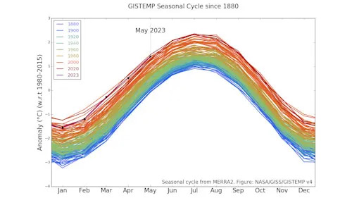
May-2023-GISTEMP-Seasonal-graph-NASA-GISS
(NASA GISS)
According to NOAA, a major contribution to the month being so warm was the extreme heat of the planet’s oceans. Based on their records, sea surface temperatures in May were 0.85°C above the 20th century average — nearly one-tenth of a degree higher than the previous record, set during the super El Niño of 2016.
This is quite remarkable, given that in May 2016 we were still in the midst of that record-setting El Niño event, while in 2023 the new El Niño had not even been officially declared.

Global-Ocean-Temp-Anom-May-2023-NOAA
Global ocean sea surface temperature anomalies for the month of May from 1850-2023, as compared to the 20th century average. May 2023 ranks as the hottest of the 173 monthly records. (NOAA NCEI)
From the first five months of global temperatures they’ve gathered, and with comparisons to how month-to-month temperatures progressed in previous years, NOAA scientists give 2023 a nearly 90 per cent chance of ending up as one of the top five warmest years in the record books. There is a roughly 50 per cent chance that it will be one of the top three hottest.
Canada sets climate extremes
During the month of May, the western half of Canada set new records due to a severe ‘heat dome’ that settled over the region.

Record-Temps-Northern-Canada-May13-2023
Although NOAA ranked the month as only the 11th warmest across the contiguous United States, due to this extreme heat across Canada, it was still the hottest month of May for the entire continent of North America.
The severity of the heat becomes more obvious when viewed on the global scale. The map below shows global temperature anomalies (compared to the 30-year average temperature from 1991-2020). Canada, and especially across eastern Northwest Territories and western Nunavut, stands out prominently.

May-2023-map-blended-mntp-NOAA
(NOAA)
Record-low Antarctic sea ice
After tracking at record-low levels through the end of 2022 and the beginning of 2023, Antarctic sea ice reached a new minimum extent at the end of February, beating out the previous record minimum set just a year earlier.
Since the beginning of May, sea ice extent in the Southern Ocean has, once again, been at record-low levels. As of June 22, the second day of southern winter, there is roughly 11.3 million square kilometres of ice in the waters around Antarctica. Compared to the same day in 2022, which had just barely set a new record low at the time, there is over 2 million square kilometres of ice ‘missing’ this year.

Antarctic-Sea-ice-Jun-22-2023-NSIDC
Antarctic sea ice extent, in millions of square kilometres, as of June 22, 2023, compared to the previous years, going back to 1979. The inset graph shows a close-up view to emphasize how much lower the extent is now compared to the previous record minimum from 2022. (NSIDC)
Record-high carbon dioxide
One of the driving forces behind the heat and loss of sea ice is the new record-high levels of carbon dioxide in Earth’s atmosphere.
According to the World Meteorological Organization, “Carbon dioxide levels measured at NOAA’s Mauna Loa observatory in Hawaii peaked at 424 parts per million in May, continuing a steady climb further into territory not seen for millions of years, according to the US National Oceanic and Atmospheric Administration (NOAA). Mauna Loa is the benchmark monitoring station in WMO's Global Atmosphere Watch network.”

Carbon dioxide June 23 2023 - mlo two years
The past two years worth of carbon dioxide measurements at Mauna Loa and Mauna Kea in Hawaii show that the peak concentration (in May of each year) has exceeded 420 ppm, and reached 424 ppm in 2023. (Scripps Institution of Oceanography)
“Measurements of CO2 obtained by NOAA’s Global Monitoring Laboratory averaged 424.0 parts per million (ppm) in May, the month when CO2 peaks in the Northern Hemisphere. That's an increase of 3.0 ppm over May 2022.”
Prior to the Industrial Revolution, going back roughly 10,000 years, carbon dioxide levels fluctuated in the atmosphere, but remained around an average of about 280 parts per million (ppm).

Carbon dioxide June 23 2023 - mlo 10k years
Carbon dioxide levels measured from proxies (ice cores, tree rings, etc) are combined here with modern records to produce a look at the past 10,000 years. (Scripps Institution of Oceanography)
With CO2 now consistently reaching a peak of over 420 ppm, this represents a more than 50 per cent increase compared to pre-industrial levels.
“The findings are of particular concern, given that the lifetime of CO2 in the atmosphere lasts for many decades, thus committing the planet to future warming,” the WMO stated.
(Thumbnail courtesy NASA GISS)
No comments:
Post a Comment