It’s possible that I shall make an ass of myself. But in that case one can always get out of it with a little dialectic. I have, of course, so worded my proposition as to be right either way (K.Marx, Letter to F.Engels on the Indian Mutiny)
Plants have microscopically small pores on the surface of their leaves called stomata. These help plants regulate the influx of carbon dioxide for photosynthesis. They also prevent the loss of too much water and withering away during drought.
The stomatal pores are surrounded by two guard cells. If the internal pressure of these cells drops, they slacken and close the pore. If the pressure rises, the cells move apart and the pore widens.
The stomatal movements are thus regulated by the guard cells. Signaling pathways in these cells are so complex that it is difficult for humans to intervene with them directly. However, researchers of the Julius-Maximilians-Universität (JMU) Würzburg in Bavaria, Germany, nevertheless found a way to control the movements of stomata remotely—using light pulses.
Light-sensitive protein from algae used
The researchers succeeded in doing this by introducing a light-sensitive switch into the guard cells of tobacco plants. This technology was adopted from optogenetics. It has been successfully exploited in animal cells, but the application in plant cells it is still in its infancy.
The team led by JMU biophysicist and guard cell expert Professor Rainer Hedrich describes their approach in the journal Science Advances. JMU researchers Shouguang Huang (first author), Kai Konrad and Rob Roelfsema were significantly involved.
The group used a light-sensitive protein from the alga Guillardia theta as a light switch, namely the anion channel ACR1 from the group of channelrhodopsins. In response to light pulses, the switch ensures that chloride flows out of the guard cells and potassium follows. The guard cells lose internal pressure, slacken and the pore closes within 15 minutes. "The light pulse is like a remote control for the movement of the stomata," says Hedrich.
Anion channel hypothesis confirmed
"By exposing ACR1 to light, we have bridged the cell's own signaling chain, thus proving the hypothesis that the opening of anion channels is essential and sufficient for stomatal closure," Hedrich says. The exposure to light had almost completely prevented the transpiration of the plants.
With this knowledge, it is now possible to cultivate plants with an increased number of anion channels in the guard cells. Plants equipped in this way should close their stomata more quickly in response to approaching heat waves and thus be better able to cope with periods of drought.
"Plant anion channels are activated during stress; this process is dependent on calcium. In a follow up optogenetics project, we want to use calcium-conducting channelrhodopsins to specifically allow calcium to flow into the guard cells cell through exposure to light and to understand the mechanism of anion channel activation in detail," Hedrich says.
Basic scientific research can also benefit from the results from Würzburg: "Our new optogenetic tool has enormous potential for research," says the JMU professor. "With it, we can gain new insights into how plants regulate their water consumption and how carbon dioxide fixation and stomatal movements are coupled."
More information: Optogenetic control of the guard cell membrane potential and stomatal movement by the light-gated anion channel GtACR1, Science Advances (2021). DOI: 10.1126/sciadv.abg4619
On average, Dutch breeding birds have become more numerous in the period 1980-2010. The common species have even done better than birds in other European countries. Farmland birds are an exception: they declined sharply both in the Netherlands and elsewhere in Europe.
Dat blijkt uit onderzoek van de stichting Centrum voor Landbouw en Milieu (CLM) en het Centrum voor Milieuwetenschappen van de Universiteit Leiden (CML), online open access gepubliceerd in het Britse tijdschrift Bird Study.
In Europe, rarity played a key role
The authors looked for factors that could explain the increase and decrease of bird species in the Netherlands. They suggested that habitattype was the most important factor: for example, the intensification of agriculture could explain the decline in farmland birds.
But in 2015, a British study on bird trends in Europe from 1980 to 2010 appeared with a surprising conclusion: it was not habitat type but bird rarity that was most closely related to developments in bird populations: Common species became more rare and rare species became less rare. Wil Tamis of the CML offers a possible explanation for this population development: "It could be, for example, that in conservation policy there is more attention for these rare species, which caused them to increase in number."
Species in all rarity classes in the Netherlands are doing better
Helias Udo de Haes of the CML explains that they predicted a different trend in the Netherlands: "We suspected that in the Netherlands, it was exactly the other way around. But neither of the hypotheses proved tenable: in the Netherlands, species in all rarity classes increased, which is good news for nature. We did confirm our hypothesis that in the Netherlands habitat is a more important factor than rarity."
Nature policy pays off
According to the researchers, the fact that the habitat factor was not dominant in the European study was probably due to differences between the European regions: the intensification of agriculture occurred in most regions, but not in others. On average, the effect of habitats is therefore not so great at the European level.
In the Netherlands, it was mainly the waterfowl, marsh and forest birds that improved significantly. The main causes are probably the expansion of areas with water, marsh and forest, the improvement of water quality and the aging of the forests. In addition, dead trees remained in the forest more often. Thus, nature policy appears to be effective for those areas.
Larger bird species do better
Based on impressions from the field, the authors had also expected larger bird species to do better than smaller ones. For example, they saw increasing numbers of storks, herons, buzzards and geese. They did indeed find a difference, but it did not turn out to be statistically significant: "The explanation is probably that the British had left the geese out of their study," says Wouter van der Weijden of the Centre for Agriculture and Environment. "To keep the comparison pure, we had to do the same, even though the geese in the Netherlands have actually become more numerous. All in all, we dare to conclude that the larger species are indeed doing better than the smaller ones."
Impact insect decline not yet visible
Finally, the authors also expected that the food choice of birds would have an effect on the increase and decrease of different species. The researchers based their suspicion on, for example, the alarming reports about the decline of insects. But the group of insectivorous birds did not do worse in the Netherlands than the other groups.It is possible that the strong decline in insects only took place after 2000, i.e. in the last decade of their research period, which made it difficult to identify the effect.
Both regional and European analysis for targeted nature policy
According to Udo de Haes research illustrates the importance of regional as well as European trend analyses. "It reveals various trends and factors. It is important to combine both scale levels for a targeted nature policy. It has also become clear once again that we have to pay much more attention to the birds of the farmlands. In addition, research is needed into trend differences in a wider range of habitats (such as urban, coastal, heathland and dune), and a wider range of species groups. Think of subgroups of insectivores, generalists versus specialists, migratory birds versus resident birds and protected versus non-protected species. That could be very informative."
More information: Helias A. Udo de Haes et al, Comparison of breeding bird trends between the Netherlands and Europe, Bird Study (2021). DOI: 10.1080/00063657.2021.1939652
Bill aims to spend billions to fix nation's aging dams
by Michael Casey
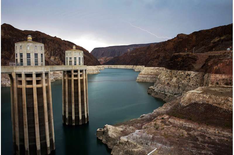
In this July 28, 2014, file photo, lightning strikes over Lake Mead near Hoover Dam that impounds Colorado River water at the Lake Mead National Recreation Area in Arizona. Lawmakers in Congress have introduced a bill that would pump tens of billions of dollars into fixing and upgrading the country's dams. The bill, introduced by Democratic U.S. Rep. Annie Kuster of New Hampshire, proposed to spend nearly $26 billion to make the repairs that would enhance safety and increase the power generation capacity of the country's dams.Credit: AP Photo/John Locher, File
Lawmakers in Congress on Friday introduced a bill that would pump tens of billions of dollars into fixing and upgrading the country's dams.
The Twenty-First Century Dams Act, introduced by Democratic U.S. Rep. Annie Kuster of New Hampshire, proposes to spend nearly $26 billion to make the repairs that would enhance safety and increase the power generation capacity of the country's 90,000 dams. It also calls for removing any dams that have outlived their usefulness.
"We have the opportunity to build stronger, more resilient water infrastructure and hydropower systems in the United States, and the Twenty-First Century Dams Act advances an innovative plan to rehabilitate, retrofit, or remove U.S. dams to bolster clean energy production while taking steps to conserve our waterways for generations to come," Kuster said in a statement.
The bill, which U.S. Sen. Dianne Feinstein is expected to introduce in the Senate, comes amid concerns that thousands of dams are at increasing risk of failure, especially as climate change is leading to more frequent and intense storms. State and local officials have long acknowledged the problems but complain they lack the funds to properly inspect, repair and maintain their dams.
In 2019, The Associated Press identified at least 1,688 high-hazard dams rated in poor or unsatisfactory condition as of the prior year in 44 states and Puerto Rico. The AP analysis noted that the actual number is almost certainly higher.
The AP's investigation focused on high-hazard dams—which could kill people if they were to fail—that were found by inspectors to be in the worst condition. Georgia led the way with 198 high-hazard dams in unsatisfactory or poor condition, followed by North Carolina with 168 and Pennsylvania with 145.
Inspection reports cited a variety of problems: leaks that can indicate a dam is failing internally; unrepaired erosion from past instances of overtopping; holes from burrowing animals; tree growth that can destabilize earthen dams; and spillways too small to handle a large flood.
In this July 25, 2018 photograph, a man pushes a stroller while walking a dog at the foot of the Wachusett Reservoir Dam, which holds back up to 65 billion gallons of water, in Clinton, Mass. Lawmakers in Congress have introduced a bill that would pump tens of billions of dollars into fixing and upgrading the country's dams. The bill, introduced by Democratic U.S. Rep. Annie Kuster of New Hampshire, proposed to spend nearly $26 billion to make the repairs that would enhance safety and increase the power generation capacity of the country's dams. Credit: AP Photo/Charles Krupa, File
The nation's dams are on average more than a half-century old, but there is no national standard for inspecting them. That's led to a patchwork of state regulations in which some high-hazard dams are inspected annually while others wait up to five years.
"Deficient and unregulated dams pose a public-safety threat to thousands of U.S. citizens, their property, and the environment," Lori Spragens, executive director of the Association of State Dam Safety Officials, said in a statement. "Recent dam failures and incidents show the urgent need for stronger state and federal dam safety programs and policies to ensure the safety of communities living near dams."
In May 2020, the hydroelectric Edenville Dam in Michigan failed during heavy rains, unleashing a torrent of water on the Tittabawassee River, which then overwhelmed Sanford Dam downstream. The flooding caused more than $250 million in damage, drained lakes that had been formed by the dams and forced thousands of residents to evacuate their homes.
Kuster's bill, which has the support of the hydropower industry and environmental groups, would offer a 30% tax credit for qualifying dams for safety, environmental improvements, grid flexibility, and dam removals.
"Hydropower's existing fleet plays a significant role in America's clean energy infrastructure, and will play a critical role in achieving President Biden's goal of a zero-carbon electricity grid," Malcolm Woolf, the CEO and president of the National Hydropower Association, said in a statement. "With the right tools, we can optimize generation efficiency and output, make environmental enhancements, and bolster dam safety."
It also would provide funding that aims to reconnect about 10,000 miles (16,000 kilometers) of rivers through the removal of 1,000 dams.
"Healthy, free-flowing rivers are essential to our future as we face the challenges of climate change. Investing in dam removal and river restoration will revitalize ecosystem health, improve public safety and strengthen communities," Tom Kiernan, the president of American Rivers, said in a statement.
An example of the seabed morphology data acquired with the multibeam echosounder showing eroded seafloor at a submarine canyon head off Grays Harbor, Washington.
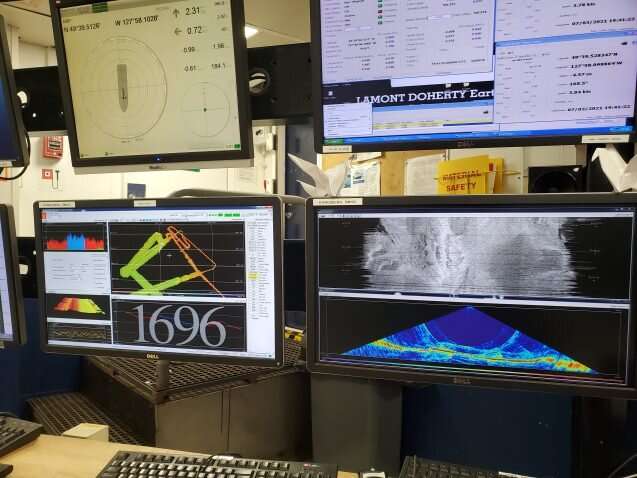
Down in the main lab of the R/V Marcus Langseth, you'll find an array of monitors—46, to be exact!—all displaying information about the data we're collecting. While many of the screens are dedicated to monitoring the seismic data and the instrumentation related to collecting the seismic data, there are two screens that display data related to the multibeam echo sounder. A multibeam echo sounder is an instrument mounted to the hull of the vessel that emits sound waves in a fan shape beneath the ship. The sound waves travel through the water to the seafloor and back to the instrument. The time it takes for the sound waves to return is used to determine the depth of the seafloor, which gives us information on the shape of the seafloor—known as bathymetry. This information complements the deep subsurface imaging provided by the seismic data.
The two monitors dedicated to the multibeam allow us to control and see thedatathat is being collected. One of the screens shows the multibeam data in map view, allowing us to see the coverage and set the parameters for the instrument (Figure 1, left screen). The other screen is split into two windows that display the data in real time (Figure 1, right screen). The top window displays theseafloorreflectivity, a measure of the hardness or roughness of the seabed. The bottom window displays the data as a side swath, which essentially is a side view of the data as if we were looking at it from the behind the vessel.
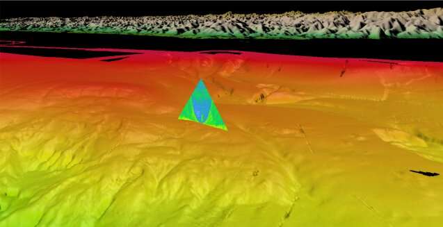
What exactly are we looking for in the multibeam data? In Figure 2, below, we can see a dynamic environment at the seafloor in southern Oregon with gullies, channels, and landslides all imaged along this small section of the margin. In addition to seafloor imaging, modern multibeam systems are capable of imaging gas bubbles within the water column. A methane seep can be seen in the new dataset which corresponds to a previously identified seep that may contain helium leaking from the Earth's mantle. New imaging techniques (Figure 3) are allowing researchers to better locate where these methane seeps are emanating from the seafloor.
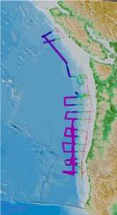
Figure 4: The coverage of new multibeam bathymetry data collected during our survey. As of June 30, the vessel has collected about 26,500 square kilometers of new data, with the rainbow-colored sections outlining the surveyed area.
Figure 1: Picture of the two screens in the main lab dedicated to the multibeam echo sounder. The left screen displays the map of coverage and windows to adjust parameters. The right screen displays the data in real time in two different formats.
Figure 2: A 3D perspective view of southern Oregon with physiographic annotations and fan view image of a methane seep. More information on methane seep exploration and seafloor mapping is available from NOAA’s Pacific Marine Environmental Laboratory
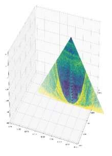
Figure 3: Annotated water-column swath of multibeam data with methane seeps identified.
Figure 4: The coverage of new multibeam bathymetry data collected during our survey. As of June 30, the vessel has collected about 26,500 square kilometers of new data, with the rainbow-colored sections outlining the surveyed area.
Figure 1: Picture of the two screens in the main lab dedicated to the multibeam echo sounder. The left screen displays the map of coverage and windows to adjust parameters. The right screen displays the data in real time in two different formats.
Careful review and interpretation of multibeam and sonar data in previous studies reveal thousands of methane seeps all scattered along the Cascadia margin. During our expedition, with the multibeam we have confirmed the location of some of these previously mapped seeps but have also identified some new ones. With careful and attentive eyes, you can spot these methane seeps in real time through the side-sweep window. However, the seeps are small in comparison to the spatial coverage of the multibeam, so they are really easy to miss and can disappear from the screen with a blink of an eye. Because of that, we mainly confirm and identify the methane seeps during the processing steps of the multibeam data. While processing the data, we are able to stack and filter to more accurately image and locate the methane seeps (Figure 3).
The multibeam data can reveal many important and interesting insights about the seafloor. Incorporating the new multibeam data collected on this cruise is one step further to having a complete high-resolution seafloor map and catalog of methane seeps along Cascadia.
Ordovician black shales of the Mount Hare Formation, Road River Group (approximately 465 million years old) rise above conglomerates of the Aberdeen Member. The dangerous rapids of Aberdeen Canyon (Nan Zhak Nadhàdlaii), created by the Peel River cutting through the resistant conglomerates, appear at bottom left. Credit: Erik Sperling
Hundreds of millions of years ago, in the middle of what would eventually become Canada's Yukon Territory, an ocean swirled with armored trilobites, clam-like brachiopods and soft, squishy creatures akin to slugs and squid
A trove of fossils and rock layers formed on that ancient ocean floor have now been unearthed by an international team of scientists along the banks of the Peel River a few hundred miles south of the Arctic's Beaufort Sea. The discovery reveals oxygen changes at the seafloor across nearly 120 million years of the early Paleozoic era, a time that fostered the most rapid development and diversification of complex, multi-cellular life in Earth's history.
"It's unheard of to have that much of Earth's history in one place," said Stanford University geological scientist Erik Sperling, lead author of a July 7 study detailing the team's findings in Science Advances. Most rock formations from the Paleozoic Era have been broken up by tectonic forces or eroded over time. "There's nowhere else in the world that I know of where you can study that long a record of Earth history, where there's basically no change in things like water depth or basin type."
Oxygen was scarce in the deep water of this and other oceans at the dawn of the Paleozoic, roughly 541 million years ago. It stayed scarce until the Devonian, roughly 405 million years ago, when, in a geological blink—no more than a few million years—oxygen likely rocketed to levels close to those in modern oceans and the diversity of life on Earth exploded. Big, predatory fish appeared. Primitive ferns and conifers marched across continents previously ruled by bacteria and algae. Dragonflies took flight. And all of this after nearly four billion years of Earth's landscapes being virtually barren.
Scientists have long debated what might have caused the dramatic shift from a low oxygen world to a more oxygenated one that could support a diverse web of animal life. But until now, it has been difficult to pin down the timing of global oxygenation or the long-term, background state of the world's oceans and atmosphere during the era that witnessed both the so-called Cambrian explosion of life and the first of Earth's "Big Five" mass extinctions, about 445 million years ago at the end of the Ordovician.
"In order to make comparisons throughout these huge swaths of our history and understand long-term trends, you need a continuous record," said Sperling, an assistant professor of geological sciences at Stanford's School of Earth, Energy & Environmental Sciences (Stanford Earth).
Context for past life
With permission from the Na Cho Nyak Dun and Tetlit Gwitch'in communities in Yukon, Sperling's team, which included researchers from Dartmouth College and the Yukon Geological Survey, spent three summers at the Peel River site. Arriving by helicopter, the research team hacked through brush with machetes beside Class VI rapids to collect hundreds of fist-sized samples of rock from more than a mile of interbedded layers of shale, chert and lime mudstone.
Back at Sperling's lab at Stanford, a small army of summer undergraduates and graduate students worked over five summers to help analyze the fossils and chemicals entombed in the rocks. "We spent a lot of time splitting open rocks and looking at graptolite fossils," Sperling said. Because graptolites evolved a vast array of recognizable body shapes relatively quickly, the pencil-like markings left by the fossils of these colony-dwelling sea creatures give geologists a way to date the rocks in which they're found.
Once the researchers had finished identifying and dating graptolite fossils, they ground the rocks in a mill, then measured iron, carbon, phosphorous and other elements in the resulting powder to assess the ocean conditions at the time and place where the layers formed. They analyzed 837 new samples from the Peel River site, as well as 106 new samples from other parts of Canada and 178 samples from around the world for comparison.
Winners and losers
The data show low oxygen levels, or anoxia, likely persisted in the world's oceans for millions of years longer than previously thought—well into the Phanerozoic, when land plants and early animals began to diversify. "The early animals were still living in a low oxygen world," Sperling said. Contrary to long-held assumptions, the scientists found Paleozoic oceans were also surprisingly free of hydrogen sulfide, a respiratory toxin often found in the anoxic regions of modern oceans.
When oxygen eventually did tick upward in marine environments, it came about just as larger, more complex plant life took off. "There's a ton of debate about how plants impacted the Earth system," Sperling said. "Our results are consistent with a hypothesis that as plants evolved and covered the Earth, they increased nutrients to the ocean, driving oxygenation." In this hypothesis, the influx of nutrients to the sea would have given a boost to primary productivity, a measure of how quickly plants and algae take carbon dioxide and sunlight, turn them into new biomass—and release oxygen in the process.
The change probably killed off graptolites. "Although more oxygen is really good for a lot of organisms, graptolites lost the low oxygen habitat that was their refuge," Sperling said. "Any environmental change is going to have winners and losers. Graptolites might have been the losers."
More information: Erik A. Sperling et al, A long-term record of early to mid-Paleozoic marine redox change, Science Advances (2021). DOI: 10.1126/sciadv.abf4382
Example image of two meteorites deployed during a field test near Walker Lake, Nevada. The meteorites are marked with orange flags. Note the dark shadow of the quadrictoper drone. Credit: Robert Citron et al.
Planetary scientists estimate that each year, about 500 meteorites survive the fiery trip through Earth's atmosphere and fall to our planet's surface. Most are quite small, and less than 2% of them are ever recovered. While the majority of rocks from space may not be recoverable due to ending up in oceans or remote, inaccessible areas, other meteorite falls are just not witnessed or known about.
But new technology has upped the number known falls in recent years. Doppler radar has detected meteorite falls, as well as all-sky camera networks specifically on the lookout for meteors. Additionally, increased use of dashcams and security cameras have allowed for more serendipitous sightings and data on fireballs and potential meteorite falls.
A team of researchers is now taking advantage of additional technology advances by testing out drones and machine learning for automated searches for small meteorites. The drones are programmed to fly a grid search pattern in a projected "strewn field" for a recent meteorite fall, taking systematic pictures of the ground over a large survey area. Artificial intelligence is then used to search through the pictures to identify potential meteorites.
"Those images can be analyzed using a machine-learning classifier to identify meteorites in the field among many other features," said Robert Citron of the University of California, Davis, in a recent paper published in published in Meteoritics & Planetary Science.
Citron and his colleagues have tested their conceptual drone setup several times, mostly recently in the area of a known 2019 meteorite fall near Walker Lake, Nevada. Their proof-of-concept meteorite classifier deploys a combination of "different convolution neural networks to recognize meteorites from images taken by drones in the field," the team writes.
Video from “Meteorite Men” which describes a strewn field.
While this specific test revealed a number of false positives for rocks previously unidentified, the software was able to correctly identify test meteorites placed by the researchers on the dry lake bed in Nevada. Citron and his team are very optimistic about the potential of their system, particularly in searching for small meteorites and finding them in remote regions.
Citron told Universe Today the main challenge for setting up the system was assembling a training dataset for the machine learning classifier.
"Since a future meteorite fall could occur on any terrain," he said via email, "the system needed an object detection algorithm trained with examples of many types of meteorites on various terrain types. To create a properly trained object detection network, thousands of example images are required."
Citron and colleagues assembled images of meteorites from the internet and added in "posed" photos of meteorites from their collection on various terrains. This allowed them to properly train the machine learning model to minimize the number of ordinary rocks flagged as false detections.
A bright meteor caught by one of the Global Fireball Network’s cameras from the Rancho Mirage Observatory (Eric McLaughlin) on April 7, 2019. Credit: NASA Meteorite Tracking and Recovery Network
"Fortunately, every field test we gain more data that we can incorporate into the dataset and use to retrain the object detection network and improve the accuracy," Citron said. "So, we will continue to try and improve the detection accuracy. Currently we need a better drone with a higher resolution camera."
Studying meteorites and knowing their origins helps scientists determine the composition of some 40 asteroid families in the asteroid belt, and also aids in understanding the early evolution of the solar system. The researchers said that the remote camera network information combined with being able to find and study freshly fallen meteorites is crucial in determining what asteroid family might have produced the meteoritic debris, and if it was from a particular collision event.
"If the meteorite can be recovered, a fireball's light curve and deceleration profile also provides information about how its kinetic energy is deposited in the Earth's atmosphere," the team wrote in their paper. "That information can be used to improve predictions at what altitude asteroids of this material type fragment that are big enough to cause damaging airbursts."
However, finding meteorites from an observed fall can be very difficult, since meteorites can be scattered over a wide area.
"Smaller falls are more frequent but deliver less meteorite fragments which are therefore harder to locate," Citron said. "It takes approximately 100 man-hours to find one meteorite fragment, so if we can improve on that we can sample more of these small falls and get better insight into the orbits and therefore source regions of incoming meteors."
An example of a small, freshly-fallen meteorite in situ, found and photographed by Geoffrey Notkin. This specimen is Ash Creek, an L6 stone meteorite, which fell on February 15, 2009 in McLennan County, Texas, following a bright daytime fireball. This was the first time Doppler radar was used to locate specimens. Credit: Geoffrey Notkin
Citron said that his team's drone system is intended for smaller falls that would not attract meteorite hunters. But the team's work has attracted the admiration of one noted meteorite hunter, Geoffrey Notkin of the Discovery Channel's "Meteorite Men."
"Dr. Citron's current work in this area is fascinating, especially his bold experiments with drones in real-world situations," Notkin said via email. "The most exciting concept here is the coupling of modern drones with machine learning that can recognize the visual characteristics of meteorites in situ. Given time, this methodology could eliminate some of the tedium of searching for freshly-fallen meteorites on foot and also facilitate recoveries in areas that are difficult or dangerous for humans to search in person."
Notkin added that he has long thought that drones and uncrewed aerial vehicles (UAVs) could play a useful role in meteorite recovery, and in fact, he carried out some early experiments in 2010 and 2011, but the drones and UAVs of the time were either not advanced enough or not available to non-military personnel.
But as technology continues to improve, Citron said, and "with a larger training dataset, updated classification scheme, and improved imaging hardware, machine learning coupled to an autonomous drone survey could prove a valuable tool for increasing the number of meteorite fragments found from fresh falls."
More information: Robert I. Citron et al, Recovery of meteorites using an autonomous drone and machine learning, Meteoritics & Planetary Science (2021). DOI: 10.1111/maps.13663
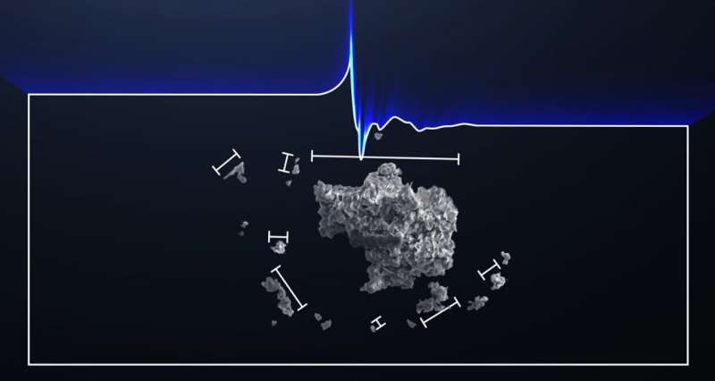
ANOTHER chunk of a rare space rock has been dug up in a muddy field.
Experts believe it is part of a 4.5billion-year-old meteorite, thought to be the first to land in Britain in 30 years. 1The latest find was in the Cotswolds village of WoodmancoteCredit: SWNS
The latest fragment was unearthed about four miles from the first.
The yellow-green rock, containing the building blocks of life, is bigger than the original find. And it bears a likeness to a human face, some say. It almost certainly belongs to the same meteor which was seen burning up over Gloucestershire in February.
Fragments were later found in sheep poo on a farm in Winchcombe.
The latest find was in the Cotswolds village of Woodmancote.
Chemist Derek Robson, of Loughborough, Leics, hailed his discovery as a “very special moment”.
Scientists discover solar system ingredients inside Winchcombe meteorite
Researchers have been conducting scientific investigations on a meteorite that fell in the UK. The meteorite is known as the Winchcombe meteorite and landed in a driveway in Winchcombe, Gloucestershire, in March of this year. The meteorite is 4.5 billion years old, making it a very rare type of rock that was around at the birth of the solar system.
Researchers say the meteorite still holds its unique chemistry, so they will be able to get an idea of the ingredients present at the birth of the solar system from studying its chemical composition. Scientists have been able to date the rock with initial analysis showing it is an extremely rare type of meteorite called a carbonaceous chondrite. Meteorites of that type are rich in carbon, water, and organic matter.
Investigators have been specifically probing the organic matter present in the meteorite. Researcher Professor Mark Sephton says the organic molecules in the rock are older than the Earth itself. He notes that similar molecules would have rained down on the early Earth before life emerged and could represent the first chemical steps towards life in the early solar system.
The organic molecules in the meteorite could be leftover ingredients from the early recipe for life on Earth. A small part of the organic content of the meteorite is present as free molecules that can be extracted using solvents. However, the larger part is present as a large organic network requiring heat and hydrogen to break into small fragments that can be investigated.
Simply finding the meteorite was a challenge. A team of researchers was able to pinpoint its location using images and video footage. Among the data used to locate the meteorite were images captured by the UK Fireball Network. European scientists say that about 20 meteorites land on earth each year over the UK, most no bigger than the size of a sugar cube, making them difficult to find.
Astronomers map interstellar dust grains in Milky Way
Between the stars in our Milky Way, vast amounts of tiny dust grains are floating aimlessly around. They form the building blocks of new stars and planets. But we still don't know what elements exactly are available to form planets like Earth. A research team at SRON led by Elisa Costantini has now matched observations from X-ray telescopes with data from synchrotron facilities to create a map of interstellar grains in the Milky Way.
If our galaxy shrank to the point where stars were the size of marbles, there would still be about a thousand kilometers between each of them. So it is safe to say that galaxies consist mostly of empty space. Still, this space is not as empty as you might think. It is filled with the so-called interstellar medium. The larger part of this is made up of tenuous gas, but around one percent is in the form of tiny grains of about 0.1 micron—one thousandth the width of a human hair.
These grains are formed during the life cycle of stars. A star, and the planets around it, are formed by a collapsing cloud of gas and dust. When the star evolves toward the end of its life, it expels a good fraction of its mass in the surrounding medium, creating new material for dust formation. If the star ends its life with a supernova explosion, it will further enrich the environment with even more gas and dust. This in turn will eventually constitute new building blocks for stars and planets. As Carl Sagan said, "We are made of stardust." But what elements exactly are available in the interstellar medium to form planets like Earth is still unknown.
The interstellar dust research group at SRON Netherlands Institute for Space Research, led by Elisa Costantini, has now studied the interstellar grains in our Milky Way using X-ray radiation. They were able, for the first time, to explore the properties of the dust in central regions of the galaxy, and found that those grains are consistently made of a glassy silicate: Olivine, which is a compound of magnesium, iron, silicon and oxygen. The interaction with stellar radiation and cosmic rays melted these grains to form little glassy irregular spheres. When moving further out to more diffuse regions away from the galactic center, the team found clues for the presence of a larger variety in dust composition. This may give rise to diversified planetary systems. It might even be that our planetary system is the exception rather than the norm.
Costantini comments, "Our solar system was formed in the outer regions of the galaxy and is the result of a complex sequence of events, including nearby supernova explosions. It remains an open question what is the right environment to form planetary systems and which of these events are vital to form a planet where life can flourish."
To get to their results, Costantini and her group matched observations from X-ray telescopes and synchrotron facilities. They used the latter to characterize the features that interstellar dust analogues like silicates, oxides and sulfates produce in X-rays. Then they compared these to the astronomical data to find the best matches. Observing several lines of sight allowed them to explore different environments of the Milky Way.
The research team used using the synchrotron facilities Soleil-LUCIA beamline, the Dubble-ESRF beamline and the Titan electron microscope at the University of Cadiz. On the astronomical side, they used the X-ray observatories XMM-Newton (ESA) and Chandra (NASA).


 rise above conglomerates of the Aberdeen Member. The dangerous rapids of Aberdeen Canyon (Nan Zhak Nadhàdlaii), created by the Peel River cutting through the resistant conglomerates, appear at bottom left. Credit: Erik Sperling")

 on April 7, 2019. Credit: NASA Meteorite Tracking and Recovery Network")