Friday, May 27, 2022

Rivers can suddenly change course – scientists used 50 years of satellite images to learn where and how it happens


Satellite image of the Irrawaddy River delta in Myanmar, a major rice growing area.
European Space Agency, CC BY-SA

Published: May 26, 2022
THE CONVERSATION

Throughout history, important cities around the world have flourished along river banks. But rivers can also be destructive forces. They routinely flood, and on rare occasions, they can abruptly shift pathways.

These “channel-jumping” events, which are called avulsions, have caused some of the deadliest floods in human history. Avulsions on China’s Yellow River killed over 6 million people in the late 19th and early 20th centuries. Similar events have been linked to the decline of Mesopotamian civilization along the Tigris and Euphrates rivers in what is now Iraq, Kuwait, Turkey and Syria.

In a newly published study, I worked with colleagues to map the global distribution of avulsions on river fans and deltas. We used satellite images of over 100 rivers from 1973 to the present, providing a half-century of bird’s-eye views of global river evolution.

We discovered 113 river avulsion events in temperate, tropical and dry climates. Of these events, 33 were on alluvial fans. These land forms develop when rivers flow out of mountains or canyons onto an open plain or into the ocean and spread out, depositing dirt and gravel in a triangle-shaped area.

The other 80 events occurred on river deltas – fertile, low-lying regions where slower-moving rivers branch into many channels that empty into lakes or the ocean, creating networks of wetlands. We used this novel data set to answer a simple question: What determines where avulsions happen?

The Mississippi River has changed course repeatedly over the past 7,000 years, depositing sediment that created much of the land of southern Louisiana.

Water seeks the lowest path

Avulsions occur because of sediment deposition. Over time, rivers deposit sediment at the avulsion site, choking up the river with sediment. Water always flows downhill, so as its current course becomes increasingly blocked, it eventually jumps to a new location.

Much like earthquakes, river avulsions happen periodically in the same places. They disperse sediment and water across the rivers’ flood plains, producing these formations’ characteristic triangular shape.

One recent example occurred in 2008, when the Kosi River in India shifted its course by over 60 miles (100 kilometers) in a matter of days, displacing over 3 million people.

In the U.S., the Mississippi River has changed course many times over the past 7,000 years. Today, a multi-dam control structure in central Louisiana keeps it from jumping its banks and joining with the Atchafalaya River, but scientists have warned that a mega-flood could overwhelm these barriers, causing widespread economic damage across southern Louisiana.

A river may not change course more than once over many decades, or even centuries. Scientists’ understanding of where these events occur is poor, and rests largely on a handful of detailed observations on large deltas, plus laboratory and computer models.
In this lab experiment, a river delta is built through repeated avulsions. As the river emerges from the canyon (left side), it slows and deposits sediment. When the river’s path becomes blocked, it changes course and drops sediment in new areas, creating a fan-shaped delta over time.


Three kinds of avulsions

Our global database revealed three distinct types of avulsions. First, the 33 avulsions on alluvial fans occurred when the rivers exited canyons. Once the rivers no longer flowed through confined valleys, they were able to spill over to one side or another toward the lowest ground.

The 80 avulsions that happened on deltas were influenced by forces in their backwaters. A river’s backwater is the zone where the speed of the current is affected by the presence of the ocean or lake at the river’s end. In this zone, the river current either slows down or speeds up in response to changing flood conditions. Scientists can estimate the backwater length from the size and slope of the river.

For example, the Mississippi River has a backwater length of nearly 300 miles (480 kilometers), which means that the speed of its flow is affected by the Gulf of Mexico all the way to a point north of Baton Rouge, Louisiana. Steeper rivers can have a backwater length scale as short as 0.6 miles (1 kilometer).
The Old River Control Structure complex in central Louisiana was built to keep the Mississippi River (left) from diverting into the Atchafalaya River, which runs off to the bottom right. Three dams allow 30% of the Mississippi’s flow to spill into the Atchafalaya and keep the rest flowing down the Mississippi’s current course (lower left to upper right). US Army Corps of Engineers/Wikipedia

When a river is flowing normally, it slows down in its backwater stretch and drops sediment onto the riverbed. However, when floods occur, the larger volume of faster-moving water erodes the riverbed.

This effect starts at the river’s mouth and moves upstream, in the opposite direction from the water’s flow, erasing some of the sedimentation that has built up prior to the flood. Ultimately, this interplay between sedimentation and erosion causes the river to choke up with sediment at a location that roughly coincides with the backwater length.

Our database showed that 50 of the 80 avulsion events that occurred on deltas happened approximately at the backwater length. For example, the Catatumbo River in South America changed course in 1982 about 6.5 miles (10.5 kilometers) inland from the point where it flows into Venezuela’s Lake Maracaibo – close to its backwater length, which is 8.5 miles (13.7 kilometers).

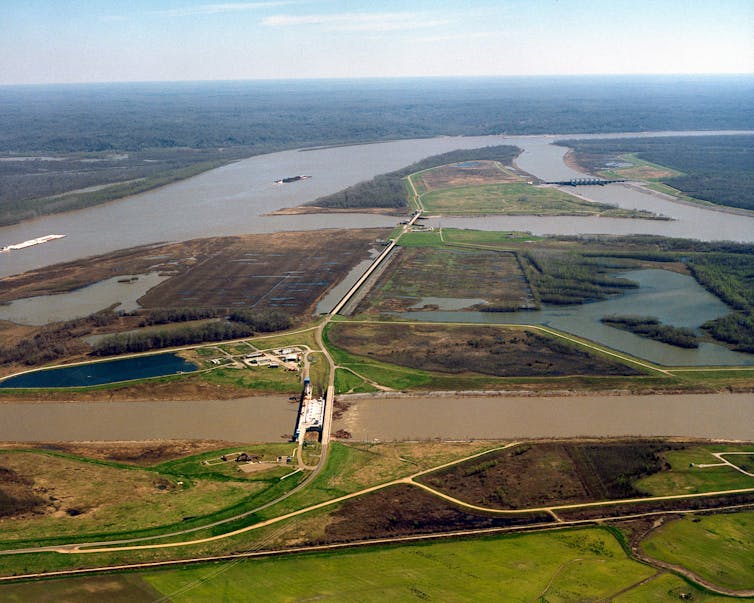
Some rivers can change course far upstream


However, we also discovered a new class of avulsions on deltas that did not reflect either valley confinement or the backwater length. These rivers changed course far upstream from the point where they were affected by the lakes or oceans at their mouths.

These deltas were either on steep tropical islands like Madagascar and Papua New Guinea or in desert environments such as Eritrea. In these places, rivers carry exceptionally large quantities of sediment during floods.

When the rivers flood, they erode their beds starting at their mouths and working backward far upriver, similar to large rivers like the Mississippi. However, the combination of long typical flood durations and exceptionally high sediment loads during floods enables the erosion to progress far upstream. As a result, these rivers can change course well above the backwater zone where avulsions happen in large coastal rivers.

More water, more sediment

Our description of these three types of avulsions provides the first framework for predicting where rivers will change course on fans and deltas worldwide. These findings have crucial implications, especia
lly for river deltas, which are home to some 340 million people around the world.


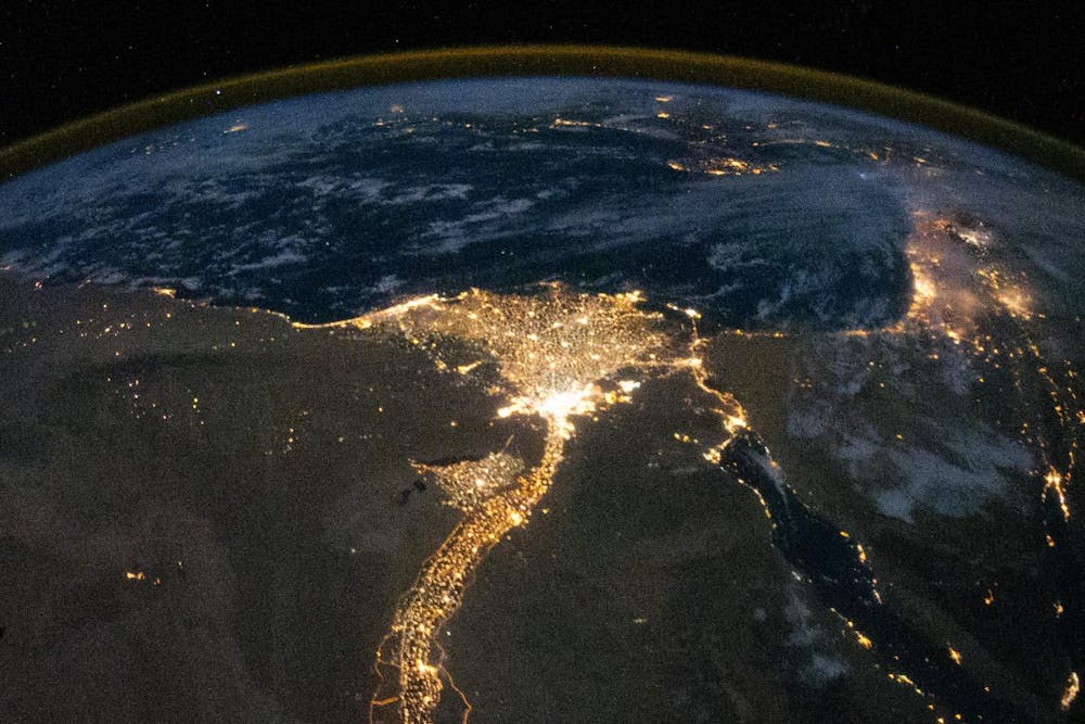
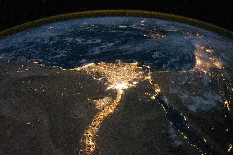
An aerial view of the Nile River delta at night from the International Space Station. Metropolitan Cairo is the bright area at the base of the fan. NASA

Most deltas are only a few feet above sea level, and some are very densely populated, such as the Mekong and Ganges-Brahmaputra deltas. Our results show that avulsion sites on deltas can move from their historic locations to new areas. Rapid sea level rise can move avulsion sites inland on deltas, exposing new communities to catastrophic flood risks.

We also found that rivers in our second group – those where avulsions occur in the backwater zone – can shift into the third group, where avulsions happen significantly farther upstream. We find that this can happen if the typical duration of flooding on a river or the river’s sediment supply changes.

Climate change is already increasing flooding in many parts of the world and washing more sediments into rivers. Land use changes, such as converting forests to farmlands, also are increasing sediment loads. In my view, it is imperative to understand how such changes can affect dynamic, volatile river systems – and the people who live around them – well into the future.

Author
Vamsi Ganti
Assistant Professor of Geography, University of California Santa Barbara
Disclosure statement
Vamsi Ganti receives funding from the National Science Foundation, and the donors of the American Chemical Society Petroleum Research Fund.


Severe Drought in Sacramento Valley Slams Farmers, Salmon and Migratory Birds
The drought has stunted grasses that Josh Davy's cattle usually feed on, so he prepares hay for them at his ranch near Red Bluff. (Miguel Gutierrez Jr./CalMatters)

Rachel Becker
CALMATTERS
May 26,2022

LONG READ


Standing on the grassy plateau where water is piped onto his property, Josh Davy wished his feet were wet and his irrigation ditch full.

Three years ago, when he sank everything he had into 66 acres of irrigated pasture in Shasta County, Davy thought he’d drought-proofed his cattle operation.

He’d been banking on the Sacramento Valley’s water supply, which was guaranteed even during the deepest of droughts almost 60 years ago, when irrigation districts up and down the valley cut a deal with the federal government. Buying this land was his insurance against droughts expected to intensify with climate change.

But this spring, for the first time ever, no water is flowing through his pipes and canals or those of his neighbors: The district won’t be delivering any water to Davy or any of its roughly 800 other customers.

'Without the water, we have dirt. It's basically worthless.'
Mathew Garcia, rice farmer, Glenn County

Without rain for rangeland grass where his cows forage in the winter, or water to irrigate his pasture, he will probably have to sell at least half the cows he’s raised for breeding and sell all his calves a season early. Davy expects to lose money this year — more than $120,000, he guesses, and if it happens again next year, he won’t be able to pay his bills.

“I would never have bought [this land] if I had known it wasn’t going to get water. Not when you pay the price you pay for it,” he said. “If this is a one-time fluke, I’ll suck it up and be fine. But I don’t have another year in me.”

Since 1964, the water supply of the western Sacramento Valley has been virtually guaranteed, even during critically dry years, the result of an arcane water rights system and legal agreements underlying operations of the Central Valley Project, the federal government’s massive water management system.

But as California weathers a third year of drought, conditions have grown so dry and reservoirs gotten so low that the valley’s landowners and irrigation districts are being forced to give up more water than ever before. Now, this region, which has relied on the largest portion of federally managed water flowing from Lake Shasta, is wrestling with what to do as its deal with the federal government no longer protects them.

 
An irrigation canal on Davy’s pasture in Shasta County is bone-dry on April 27, 2022. (Miguel Gutierrez Jr./CalMatters)

All relying on the lake’s supplies will make sacrifices: Many are struggling to keep their cattle and crops. Refuges for wildlife also will have to cope with less water from Lake Shasta, endangering migratory birds. And the eggs of endangered salmon that depend on cold water released from Shasta Dam are expected to die by the millions.

For decades, water wars have pitted growers and ranchers against nature, north against south. But in this new California, where everyone is suffering, no one is guaranteed anything.

“In the end, when one person wins, everybody loses,” Davy said. “And we don’t actually solve the problem.”


Portioning out the river's precious water


This parched valley was once a land of floods, regularly inundated when the Sacramento River overflowed to turn grasslands and riverbank forests into a vast, seasonal lake.

Colonizers who flooded into California on the tide of the Gold Rush of 1849 staked their claims to the river’s flow with notices posted to trees in a system of “first in time, first in right.”

The river was corralled by levees, the region replumbed with drainage ditches and irrigation canals. Grasslands and swamps lush with tules turned to ranches and wheat fields, then to orchards, irrigated pasture and rice.

The federal government took over in the 1930s, when it began building the Central Valley Project’s Shasta Dam, which displaced the Winnemem Wintu people. A 20-year negotiation between water rights holders — the colonizers, who comprised miners, landowners and irrigation districts — and the U.S. Bureau of Reclamation culminated in a deal in 1964.


Today, under the agreements, which were renewed in 2005, nearly 150 landowners and irrigation districts that supply almost half a million acres of agriculture in the western Sacramento Valley are entitled to receive about three times more water than Los Angeles and San Francisco use in a year.

It’s a controversial amount in the parched state. Before this year, the Sacramento River Settlement Contractors, as they’re called, received the largest portion of the federally managed supply of water that flows from Shasta Lake. It’s more than cities receive, more than wildlife refuges, more even than other powerful agricultural suppliers like the Westlands Water District farther south.

Their contract bars the irrigation districts’ supply from being cut by more than a quarter in critically dry years. During the last drought in 2014, federal efforts to cut it to 40% of the contracted amount were met with resistance, and deliveries ultimately increased to the full 75% allocation for the dry year.

But this year, facing exceptionally dry conditions, the irrigation districts negotiated with state and federal agencies, and agreed in March to reduce their water deliveries to 18%. Other agricultural suppliers with less senior rights are set to get nothing.

'Urban water use statewide increased 18.9 percent between March 2020 and 2022.'CalMatters California Water and Drought Tracker

Growers understand that they have to sacrifice some water this year, said Thaddeus Bettner, general manager for Glenn-Colusa Irrigation District, the largest of the Sacramento River Settlement Contractors and one of the largest irrigation districts in the state. But he wondered why irrigation districts in the western Sacramento Valley draw so much of the blame.

“I understand we’re bigger than everybody so we catch the focus,” Bettner said. “We’re just trying to survive this year. Frankly, it’s just complete devastation up here. And it’s unfortunate that the view seems to be that we should get hurt even more to save fish.”

Cutting deliveries to growers means that more water can flow through the rivers, which slightly raises the chances for more endangered winter-run Chinook salmon to survive this year.

“They had the water rights to take 75% of their allocation instead of 18%, and we were anticipating another total bust,” said Howard Brown, senior policy advisor with NOAA Fisheries’ West Coast Region. “One hundred percent temperature-dependent mortality [of salmon eggs] would not have been something out of reason to imagine.”

Yet more than half the eggs of endangered winter-run Chinook salmon are expected to die this year, according to the National Marine Fisheries Service.


Low water levels at Shasta Lake on April 25, 2022. (Miguel Gutierrez Jr./CalMatters)

State and federal biologists are racing to move some of the adult salmon to a cooler tributary of the Sacramento River and a hatchery.

“We’re spreading the risk around, and putting our eggs in different baskets,” Brown said. “The animal that’s on the flag of California is extinct. How many can we afford to lose before we lose our identity as people and as citizens of California?”


'Nothing like I thought I'd ever see' in the Sacramento Valley


In any other year, Davy would run his cattle on rain-fed rangeland he leases in Tehama County until late spring before moving the herd to his home pasture, kept green and lush with spring and summer irrigation.

Davy, who grew up roping and running cattle, supports his career as a full-time rancher with his other full-time job as a farm adviser with the University of California Cooperative Extension, specializing in livestock, rangelands and natural resources.

Three years ago, he sold his home in Cottonwood, on the Shasta-Tehama county line, for a fixer-upper nearby with holes in the floor, a shoddy electrical system and windows that wouldn’t close. This fixer-upper had two inarguable selling points: a view of Mount Shasta, and water from the Anderson-Cottonwood Irrigation District, a settlement contractor.

This year, without rain, the grass where his cows forage through the winter crunches underfoot.

“This grass should be up to my waist right now,” Davy said, readying a chute he would soon use to transport his cattle. He unloaded hay from his pickup to feed the cows and calves until he could move them — unheard of, he said, in April. 
Cattle feed on hay in Tehama County. (Miguel Gutierrez Jr./CalMatters)

Forty miles away, his pasture, green from the April rains, is faring a little better — but the green can’t last without irrigation. Thinking about it too hard makes Davy feel sick.

“I try to stick to what I can get done today, and then assume next year I’ll be OK. I think that’s the mantra for agriculture: Next year will be better,” he said.

About 75 miles south of Davy’s ranch, rangeland and irrigated pastures open up to orchards and thousands of acres of empty rice fields.

“Nothing like I thought I’d ever see,” said Mathew Garcia, gazing at one of his dry rice fields in Glenn, about an hour and a half north of Sacramento.

In any other year, he would have been preparing to seed and flood the crumbled clay. This year, he had to abandon even the one field he’d planned to irrigate from a well; the ground was too thirsty to hold the water.

Garcia’s water comes from two different irrigation districts with settlement contracts. This year, the roughly 420 acres he farms will see water deliveries either eliminated or too diminished to plant rice. He’ll funnel the water instead to his tenant’s irrigated pasture where cattle graze.

“Without the water, we have dirt. It’s basically worthless,” Garcia said. “It’s very depressing.”


California is one of the main rice producers in the United States, and almost all is grown in the Sacramento Valley. It’s an especially water-demanding crop: The plants and evaporation drink up about two-thirds of the flows; the rest dribbles through the earth to refill groundwater stores or flows back into irrigation ditches that supply other crops, rivers and wetlands.

Garcia places some of the blame on the weather. But he also blames federal regulators, who allow water to flow from the reservoirs year-round for fish, wildlife and water quality.

“Everybody says, well, you shouldn’t farm in the desert. Does this look like a desert to you? No. It looks like fertile, beautiful farmland with the most amazing irrigation system that’s ever been put in. And they’re just taking the water from it. They’re creating a desert,” Garcia said

. 
Mathew Garcia, standing in one of his fallow rice fields in Glenn, says he can't plant anything this year because of reduced water deliveries. (Miguel Gutierrez Jr./CalMatters)

In the depths of California’s last historic drought from 2012 through 2016, Garcia could still plant his fields. Even with last year’s reduced water deliveries, he planted — filling the gaps in water supply by pumping from his groundwater wells.

Garcia will survive this year: He credits his wife’s foresight to purchase crop insurance years ago. Without it, he said, he’d be done — he’d have to sell land, maybe find another job.

“If this drought sustains, I don’t know how long insurance is going to last. And then at what point do you throw in the towel?” said Garcia. “​​There’s a teetering point somewhere. Everybody’s is different. I don’t know where mine is yet.”

Local water suppliers anticipate that about 370,000 acres of cropland will go fallow in the western Sacramento Valley, the result of diminished deliveries to the settlement contractors. Most of those acres lie in Colusa and Glenn counties, where agriculture is the epicenter of the economy. Money and jobs radiate from the fields to the crop dusters and chemical suppliers, rice driers and warehouses.

And, like the water, jobs for farmworkers have dried up.

For nine years, Sergio Cortez has been traveling from Jalisco, Mexico, to work in Sacramento Valley fields. This is the driest he’s ever seen it, and he knows that next year could be worse.

“Aquí el agua es todo, pues,” he said. “Al no haber agua, pues no hay trabajo.” Water is everything, he said. If there’s no water, there’s no work.

The parking lot at the migrant farmworker housing in Colusa County where Cortez and his family live for part of the year was full of cars and pickups that would normally be parked at the fields. Cortez hadn’t worked in two days.

For Adolfo Morales Martinez, 74, it had been a month since he worked. And, at the end of April, his unemployment benefits were about to end.

“Desesperados. Estamos desesperados,” he said. “Pues en el campo gana uno poquito, no? Y sin nada? No mas.” We’re desperate, he said. In the fields, he can earn a little. But now, nothing.

Normally Morales Martinez drives a tractor, readying rice fields for planting. Now it’s like a desert, his wife, Alma Galavez, said.

“Eso está desértico, vea. Todo. Nada, nada. Está feo y triste,” she said. There’s nothing. It’s ugly and sad.

Extreme effects on salmon and birds, too

Environmental advocates and California tribes have been fighting the growers’ and irrigation districts’ claim to California’s finite water supply for years, citing inadequate water to maintain water quality and temperatures for endangered fish and the Sacramento Delta.

“People who have built their farms in the desert, or in areas where their water has to be exported to them, need to think about changing. Because that’s what’s killing the state,” said Caleen Sisk, chief and spiritual leader of the Winnemem Wintu Tribe, whose lands were flooded with the damming of Lake Shasta.

To Sisk, the salmon that once spawned in the tributaries above the Central Valley signal the region’s health. “If there are no salmon, there will be no people soon,” she said.

Federal scientists estimate that last year about three-quarters of endangered winter-run Chinook salmon eggs died because the water downstream of a depleted Lake Shasta was too warm. Only about 3% of the salmon ultimately survived to migrate downriver.

“It’s been clear for decades that there was a need to reduce diversions,” said Doug Obegi, senior attorney with the Natural Resources Defense Council. “The consequences are just becoming more and more extreme.”

In 2020, California sued the Trump administration over what it said were flawed federal assessments for how the Central Valley Project’s operations harm endangered species.

The judge sent the federal plans back for more work and approved what he called a “reasonable interim approach“ that called for prioritizing fish and public safety over irrigation districts. He called the contracts an “800-pound gorilla” and said they “make it exceedingly and increasingly difficult” for the federal government to be “sufficiently protective of winter-run [salmon].”

U.S. Bureau of Reclamation spokesperson Gary Pitzer said the agency worked with the districts to reach an agreement on how much water to deliver because “it’s the right thing to do, particularly during drought — one of the worst on record.”

Environmental advocacy groups applauded the reduced allocations to the Sacramento Valley irrigation districts. But they also raised concerns that other irrigation districts with similar contracts elsewhere in the state would still see their full dry-year allocations, and cautioned that the temperatures will still kill salmon by the scores this year.

Wildlife refuges where birds can rest and eat during their 4,000-mile winter journeys along the Pacific Flyway also are receiving significantly less water this year.

Curtis McCasland, manager of the Sacramento National Wildlife Refuge Complex, expects less than half a typical year’s water supply to be delivered to the refuges this year — cobbled together from purchased water supplies, federal deliveries and, he hopes, storm flows this winter.

North of Sacramento, the five refuges in the complex are painstakingly tended wilderness in a sea of agriculture. More than a century ago, wetlands fanned out for miles on either side of the flood-prone Sacramento River. Now, more than 90% of the state’s wetlands are gone, drained for fields, homes and businesses. Those remaining in these refuges now depend on water flowing from Shasta Dam and shunted through irrigation canals.

At the end of April, the Colusa National Wildlife Refuge offered an oasis among the barren rice fields, which normally provide about two-thirds of the migrating bird’s calories. Dark green bulrushes rose from shallow ponds where shorebirds jackhammered their bills in and out of the muck.

 
An American bittern feeds at the Colusa National Wildlife Refuge 
on April 28, 2022. (Miguel Gutierrez Jr./CalMatters)

McCasland knows all this lush green can’t last. As he steered an SUV past black-necked stilts picking their way through the water and ducklings paddling ferociously, he talked of bracing for another dry year.

“Instead of being those postage stamps in a sea of rice, we’re going to be postage stamps in a sea of fallow fields,” McCasland said.

In a typical year, the refuge wetlands that depend on federal water get much less water than the settlement contractors are entitled to — about 4% of the total, McCasland estimates. And he worries that this year, whatever water they do receive won’t be enough to keep all these birds fed and healthy.

More than a million birds descend on the refuges every winter to rest and find food. More stop in the surrounding rice fields, which are largely dry this year.

“In years where Shasta is at a normal or average level, it should be no problem to get us the water,” he said. “In years like this, certainly it’s going to be terribly difficult.”

The drought may already have taken a toll. Last November, only 745,000 birds landed in the refuge, a decrease of more than 700,000 from November of 2019, although some may have remained farther north because of unseasonably balmy weather there.

The refuges are like a farm, where McCasland and his colleagues carefully cultivate tule, shrubs and grasses with pulses of summertime irrigations. With less water this summer, these wintertime food sources for birds will dry and shrivel. And with less water during the peak of fall and winter migrations, hungry birds will be packed together in the few remaining marshes — raising the risk of outbreaks from diseases like avian botulism or cholera.

“There’s not a lot of places for these birds to go,” McCasland said. “The Sacramento Valley has always been the bankable piece. ... They do have wings, they may be able to move through.” But, he added, “the question is, what happens next?”

CalMatters Photo Editor Miguel Gutierrez contributed to this story.
Heatwave, water shortage: Pakistan’s mango production likely to drop by 50pc


By News Report
May 27, 2022

KARACHI: The chief of a growers and exporters association has said Pakistan's mango production is expected to decline by around 50% this year, as the crop has been severely hit by unusually high temperatures and water shortages, a British wire service reported on Thursday.

Pakistan witnessed an extreme heatwave this month, with temperatures in the south crossing 50 degrees Celsius (122 degrees Fahrenheit). The South Asian nation had jumped from winter to summer without experiencing a spring, according to the country's Climate Change Ministry.

Scientists have warned that more than a billion people are at risk from the effects of heat in the region, linking the early onset of an intense summer to climate change. "The heatwave has affected it (the crop) greatly because the temperature in March was 28.29 degrees Celsius, but all of a sudden it hit 42," said Waheed Ahmed, head of the Pakistan Fruit and Vegetable Exporters, Importers and Merchants Association.

He said the heat at the time of the flowering of mango trees affected production greatly, adding that Pakistan was facing a 50% drop in mango production this year as a result. Though the heat ripens the succulent yellow fruit, the untimely early rise in temperatures, coupled withwater shortages, has badly affected the crop. "When the unripened fruit is ready, it requires water, which helps the mango grow to a good size," said grower and contractor Gul Hassan in Tando Allah Yar, in Sindh. "There is no water in Sindh."

Ahmed said Pakistan is the world’s fifth largest producer of mangoes after India, China, Thailand, and Indonesia.

Pakistan’s average mango production is nearly 1.8 million tonnes, but likely to be around half that this year, he said, adding the association has cut its export target by 25,000 tonnes compared with last year to 125,000 tonnes.

Seattle democracy vouchers increase donations, number of candidates in city elections


Peer-Reviewed Publication

UNIVERSITY OF WASHINGTON

Each odd-year election cycle since 2017, four $25 democracy vouchers have arrived in the mail for registered voters in Seattle.

Each voucher can be donated to a single campaign for city office or dispersed to separate campaigns. According to the Seattle Ethics and Elections Commission, or SEEC, the goals of the democracy voucher program are to increase the number of voters donating to municipal elections and the number of candidates in those elections.

But is it working?

New research from the University of Washington says yes.

“We found a really big effect on donation activity,” said Alan Griffith, UW assistant professor of economics. “Together with that, we found big effects on small donations. There’s a lot more money being given to candidates in Seattle and more money coming from more donors.”

The study, published online May 19, will appear in the Journal of Public Economics.

Researchers analyzed the effect of the voucher program on Seattle city council races during the first two election cycles post-implementation. Then, they compared the outcomes pre- and post-vouchers to the next six largest cities in Washington and the largest cities in California. The California cities had populations much closer to Seattle’s, but different rules for elections and public campaigns.

Per 100,000 people, Seattle’s program increased donations by approximately $31,000, or 53%, per race and increased the number of donors per race by 350%. Candidates received about 270% more dollars through small donations, which are donations of less than $200. The study also revealed an 86% increase in the number of candidates and a large decrease in incumbent electoral success.

“How campaigns learn to interact in a world with democracy vouchers is an interesting question,” Griffith said. “Everybody has $100 to give out and the intention of the program is to shift the fundraising attention and the policy toward those people instead of people who can write big checks.”

In the 2015 Seattle City Council races, before the voucher program, candidates raised more than $400,000 per race from more than 2,000 donors on average. Due to the amount of money required to run campaigns and the relatively small number of donations, concern grew that public policy was dictated by those who had the means to donate.

That same year, city voters passed a ballot initiative that included the democracy vouchers program. When the vouchers are redeemed, the SEEC distributes the value to the campaign.

In 2017, the first year of the program, vouchers were redeemable by candidates in the city council and city attorney races. Mayoral elections were included in 2021. Nearly $1.75 million per cycle was distributed over the first two election cycles post-implementation (2017 and 2019).

“There’s been a lot of talk in Congress about scaling up and building other programs that look like Seattle’s,” Griffith said. “There’s a lot of non-government organizations that are trying to push expansion of this into different cities. People that are pushing this as a way to solve the problem of there being too much money in politics.”

The study found that between 2% and 5% of vouchers are used, meaning there is a substantial amount of money that isn’t being donated. The Seattle campaign differs from other programs in that no large grant is given to fund campaigns. It also allows voters to direct money without having to commit any of their own funds.

“There’s really no other program that gives vouchers,” Griffith said. “Seattle’s program is unique in that you’re given free money to give out. We’re not aware of any other programs that are like this.”

Thomas Noonen, who graduated from UW in 2020 with a bachelor’s degree in economics, co-authored the study.

For more information, contact Griffith at alangrif@uw.edu.

Researchers aim X-rays at century-old plant secretions for insight into Aboriginal Australian cultural heritage

By revealing the chemistry of plant secretions, or exudates, these studies build a basis for better understanding and conserving art and tools made with plant materials.

Peer-Reviewed Publication

DOE/SLAC NATIONAL ACCELERATOR LABORATORY

For tens of thousands of years, Aboriginal Australians have created some of the world’s most striking artworks. Today their work continues long lines of ancestral traditions, stories of the past and connections to current cultural landscapes, which is why researchers are keen on better understanding and preserving the cultural heritage within.

In particular, knowing the chemical composition of pigments and binders that Aboriginal Australian artists employ could allow archaeological scientists and art conservators to identify these materials in important cultural heritage objects. Now, researchers are turning to X-ray science to help reveal the composition of the materials used in Aboriginal Australian cultural heritage – starting with the analysis of century-old samples of plant secretions, or exudates.

Aboriginal Australians continue to use plant exudates, such as resins and gums, to create rock and bark paintings and for practical applications, such as hafting stone points to handles. But just what these plant materials are made of is not well known.

Therefore, scientists from six universities and laboratories around the world turned to high-energy X-rays at the Stanford Synchrotron Radiation Lightsource (SSRL) at the Department of Energy’s SLAC National Accelerator Laboratory and the synchrotron SOLEIL in France. The team aimed X-rays at 10 well-preserved plant exudate samples from the native Australian genera EucalyptusCallitrisXanthorrhoea and Acacia. The samples had been collected more than a century ago and held in various institutions in South Australia.

The results of their study were clearer and more profound than expected.

“We got the breakthrough data we had hoped for,” said Uwe Bergmann, physicist at University of Wisconsin-Madison and former SLAC scientist who develops new X-ray methods. “For the first time, we were able to see the molecular structure of a well-preserved collection of native Australian plant samples, which might allow us to discover their existence in other important cultural heritage objects.”

Researchers today published their results in the Proceedings of the National Academy of Sciences.

Looking below the surface

Over time, the surface of plant exudates can change as the materials age. Even if these changes are just nanometers thick, they can still block the view underneath.

“We had to see into the bulk of the material beneath this top layer or we’d have no new information about the plant exudates,” SSRL Lead Scientist Dimosthenis Sokaras said.

Conventionally, molecules with carbon and oxygen are studied with lower-energy, so-called “soft” X-rays, that would not be able to penetrate through the debris layer. For this study, researchers sent high-energy X-ray photons, called “hard” X-rays, into the sample. The photons squeezed past foggy top layers and into the sample’s elemental arrangements beneath. Hard X-rays don’t get stuck in the surface, whereas soft X-rays do, Sokaras said.

Once inside, the high-energy photons scattered off of the plant exudate’s elements and were captured by a large array of perfectly aligned, silicon crystals at SSRL. The crystals filtered out only the scattered X-rays of one specific wavelength and funneled them into a small detector, kind of like how a kitchen sink funnels water drops down its drain.

Next, the team matched the wavelength difference between the incident and scattered photons to the energy levels of a plant exudate’s carbon and oxygen, providing the detailed molecular information about the unique Australian samples.

A path for the future

Understanding the chemistries of each plant exudate will allow for a better understanding of identification and conservation approaches of Aboriginal Australian art and tools, Rafaella Georgiou, a physicist at Synchrotron SOLEIL, said.

“Now we can go ahead and study other organic materials of cultural importance using this powerful X-ray technique,” she said.

Researchers hope that people who work in cultural heritage analysis will see this powerful synchrotron radiation technique as a valuable method for determining the chemistries of their samples.

“We want to reach out to that scientific community and say, ‘Look, if you want to learn something about your cultural heritage samples, you can come to synchrotrons like SSRL,’” Bergmann said.

Hummingbirds may struggle to go any further uphill


Peer-Reviewed Publication

THE COMPANY OF BIOLOGISTS

Any animal ascending a mountain experiences a double whammy of impediments: the air gets thinner as it also becomes colder, which is particularly problematic for creatures struggling to keep warm when less oxygen is available. For tiny animals with the highest-octane lifestyles, such as hovering hummingbirds, the challenges of relocating to higher levels to evade climate change may be too much, but no one knew whether these extraordinary aviators may have more gas in the tank to keep them aloft at higher altitudes.

As Anna’s hummingbirds (Calypte anna) are comfortable up to elevations of ~2800 m, Austin Spence from the University of Connecticut, USA, and Morgan Tingley from the University of California, Los Angeles, USA, were curious to find out how hummingbirds that originated from close to sea level and those that live at the loftier end of the range would cope when transported well above their natural habitat to an altitude of 3800m. They publish their discovery in Journal of Experimental Biology (https://journals.biologists.com/jeb) that the birds struggle to hover and suffer a 37% drop in their metabolic rate at that height – in addition to becoming torpid for most of the night to conserve energy – making it unlikely that they can relocate to higher altitudes.

To find out how the agile aeronauts fared at high altitude, Spence lured the animals into net traps, from sites 10m above sea level (Sacramento, CA) up to 2400m (Mammoth Lakes, CA), then he and Hannah LeWinter (Humboldt State University, USA) transported them to an aviary in western California at 1215m. Once the birds had spent a few days in their new home, the scientists set up a tiny funnel into which the birds could insert their heads as they hovered while sipping tasty syrup, and measured the birds’ O2 consumption (metabolic rate). Spence and LeWinter also measured the hummingbird’s CO2 production (another measure of metabolic rate) overnight, as the tiny creatures allowed their metabolism to tumble when they became torpid – a form of mini hibernation – to conserve energy while they slept. Then, the duo relocated the birds to a nearby research station near the peak of Mount Barcroft , CA (3800m) where the air is thinner (~39% less oxygen) and colder (~5°C), and after ~4days at the new altitude, Spence and LeWinter remeasured the birds’ metabolic rates as they hovered and how often and deeply the birds went into torpor as they slumbered.

Even though the hovering hummingbirds should have been working harder to remain aloft in the thin air 1000m above their natural range, the birds actually experienced a 37% drop in their metabolic rate. And when the team compared the energy used by birds that originated close to sea level and from the higher end of their range, they all struggled equally on the mountain top. ‘Overall, these results suggest low air pressure and oxygen availability may reduce hovering performance in hummingbirds when exposed to the acute challenge of high-elevation conditions’, says Spence.

In addition to struggling to hover, the birds resorted to dropping their metabolic rate and became torpid for lengthier periods at night, spending more than 87.5% of the chilly high-altitude night in torpor. ‘It means that even if they’re from a warm or cool spot, they use torpor when its super-cold, which is cool’, says Spence. And when the team checked the size of the animals’ lungs, to find out whether the birds that originated from higher altitudes had larger lungs to compensate for their meagre oxygen supply, they did not. But the birds did have larger hearts to circulate oxygen around the body.

What does this mean for the hummingbird’s future as climate change forces them to find more comfortable conditions? ‘Our results suggest lower oxygen availability and low air pressure may be difficult challenges to overcome for hummingbirds’, says Spence, meaning that the birds will likely have to shift north in search of cooler climes.

**********************

IF REPORTING THIS STORY, PLEASE MENTION JOURNAL OF EXPERIMENTAL BIOLOGY AS THE SOURCE AND, IF REPORTING ONLINE, PLEASE CARRY A LINK TO: https://journals.biologists.com/jeb/article-lookup/doi/10.1242/jeb.243294

REFERENCE: Spence, A. R., LeWinter, H. and Tingley, M. W. (2022). Anna’s hummingbird (Calypte anna) physiological response to novel thermal and hypoxic conditions at high elevations. J. Exp. Biol. 225, jeb243294. doi:10.1242/jeb.243294.

DOI:10.1242/jeb.244313

This article is posted on this site to give advance access to other authorised media who may wish to report on this story. The story posted here is COPYRIGHTED. Advance permission is required before any and every reproduction of this article in full from permissions@biologists.com.

THIS ARTICLE IS EMBARGOED UNTIL THURSDAY, 26 MAY 2022, 18:00 HRS EDT (23:00 HRS BST)

FIRST BATS & BIRDS NOW THIS

Offshore wind farms could disturb marine mammal behavior #ASA182


As the number and size of offshore turbines increase, so does the possible disruption to aquatic life.

Reports and Proceedings

ACOUSTICAL SOCIETY OF AMERICA

DENVER, May 26, 2022 – When an offshore wind farm pops up, there is a period of noisy but well-studied and in most cases regulated construction. Once the turbines are operational, they provide a valuable source of renewable energy while emitting a constant lower level of sound.

Frank Thomsen, of DHI, will discuss how this constant noise may impact wildlife in his presentation, "Operational underwater sound from future offshore wind turbines can affect the behavior of marine mammals." The session will take place May 26 at 4:25 p.m. Eastern U.S. as part of the 182nd Meeting of the Acoustical Society of America at the Sheraton Denver Downtown Hotel.

Thomsen and colleagues reviewed published sound levels from operational wind farms to identify trends with turbine size. In general, the larger the turbine, the higher the noise emissions.

However, newer wind farms using quieter driving technology can to a certain extent cancel out the impact of larger turbines. Older gear box technology reaches disruptive levels for marine mammals up to 6.3 kilometers away. In contrast, newer direct drive turbines are expected to only impact animal behavior within a 1.4-kilometer radius.

"It is very unlikely that operational noise will lead to any injury or even hearing impairment, but behavioral changes could be a concern, as our study shows," Thomsen said. "It's possible that impact zones of individual turbines overlap, but that still does not mean that the wind farm is a no-go area for marine life. We see harbor porpoises frequently swimming in the vicinity of turbines."

The long-term consequences of this noise on wildlife are still largely unknown. The impact could depend on the number of turbines and their overlapping affected areas.

In theory, the sound can lead to behavior changes in marine mammals and mask calls from whales, but harbor porpoises are frequently seen swimming in the vicinity of wind farms in Europe, so it may not be as simple as it seems.

"Since offshore wind farms have a relatively long lifespan, and there will be many of them, the potential impacts should not be overlooked," said Thomsen. "The point of our work is to raise awareness."

----------------------- MORE MEETING INFORMATION -----------------------

USEFUL LINKS

Main meeting website: https://acousticalsociety.org/asa-meetings/

Technical program: https://eventpilotadmin.com/web/planner.php?id=ASASPRING22

Press Room: https://acoustics.org/world-wide-press-room/


WORLDWIDE PRESS ROOM

In the coming weeks, ASA's Worldwide Press Room will be updated with additional tips on dozens of newsworthy stories and with lay language papers, which are 300 to 500 word summaries of presentations written by scientists for a general audience and accompanied by photos, audio and video. You can visit the site during the meeting at http://acoustics.org/world-wide-press-room/.


PRESS REGISTRATION

We will grant free registration to credentialed journalists and professional freelance journalists. If you are a reporter and would like to attend, contact AIP Media Services at media@aip.org.  For urgent requests, staff at media@aip.org can also help with setting up interviews and obtaining images, sound clips, or background information.


ABOUT THE ACOUSTICAL SOCIETY OF AMERICA

The Acoustical Society of America (ASA) is the premier international scientific society in acoustics devoted to the science and technology of sound. Its 7,000 members worldwide represent a broad spectrum of the study of acoustics. ASA publications include The Journal of the Acoustical Society of America (the world's leading journal on acoustics), JASA Express Letters, Proceedings of Meetings on Acoustics, Acoustics Today magazine, books, and standards.

Race, ethnicity, and poverty linked to worse outcomes in children treated for high-risk neuroblastoma


Cancer of immature nerve cells arising from the adrenal gland, nerve ganglia or the neck. This causes abdominal pain, diarrhea or constipation, lumps of tissue under the skin, wheezing and weight loss.
Condition Highlight
Urgent medical attention is usually recommended by healthcare providers
Condition Highlight
Can be dangerous or life threatening if untreated
How common is condition?
Very rare (Fewer than 1,000 cases per year in Canada)
Is condition treatable?
Treatable by a medical professional
Does diagnosis require lab test or imaging?
Requires lab test or imaging
Time taken for recovery
Can last several years or be lifelong
Condition Image

Reports and Proceedings

DANA-FARBER CANCER INSTITUTE

BOSTON - Children with high-risk neuroblastoma had worse outcomes if they were from certain racial/ethnic groups or were on public rather than private insurance, despite being treated in clinical trials with standardized protocols, according to a study led by investigators from Dana-Farber/Boston Children’s Cancer and Blood Disorders Center.

The study shows that young patients from historically marginalized populations or from lower-income backgrounds had poorer five-year survival rates even when they were assigned to receive uniform initial treatment after diagnosis with high-risk neuroblastoma.

“These findings recapitulate what we have known for decades at the population level—children from historically marginalized groups are less likely to survive their cancer,” said Puja J. Umaretiya, MD, a clinical fellow in pediatric hematology/oncology at Dana-Farber/Boston Children’s. “They add an essential next layer to our understanding of racial and ethnic disparities in childhood cancer, and that is that enrollment on clinical trials is not enough to achieve racial and ethnic equity in survival.” Umaretiya is presenting the study results at the American Society of Clinical Oncology (ASCO) Annual meeting, being held June 3-7, 2022, and the study is included in the ASCO press program.

“Clinical trials represent highly standardized care – yet even when receiving care on clinical trials, children with high-risk neuroblastoma do not experience the same outcomes based on their race, ethnicity, and whether they live in poverty,” said Umaretiya, lead author of the study. “This is key, because thus far attention has been paid to getting historically marginalized groups to trials with the assumption that this will reduce survival disparities, but our data suggest that in pediatrics, trial-enrollment is a first step, but clearly not a sufficient one.”

Senior author is Kira Bona, MD, MPH, a pediatric oncologist at Dana-Farber/Boston Children’s with research focused on identifying poverty-associated outcome disparities in childhood cancer and developing interventions to mitigate those disparities.

Bona notes, “That stark racial/ethnic disparities in survival persist despite clinical trial participation makes it crystal clear that pediatric oncology trials must incorporate health equity interventions. If a new gene mutation were found to increase risk for trial-enrolled patients, pediatric oncology would not hesitate to begin intervening. That same urgency must apply to these data. It is imperative that pediatric oncologists begin to test healthcare delivery and supportive care interventions in our trials just like we do new drugs.”

The study looked at outcomes in 696 children enrolled in three Children’s Oncology Group (COG) clinical trials of treatment for high-risk neuroblastoma. Neuroblastoma is a type of cancer that forms in nerve tissue. It frequently begins in one of the adrenal glands but can also originate in the neck, chest, abdomen, or spine. High-risk disease is defined by age, how widely the disease has spread, and biologic characteristics of the cancer cells. The prognosis for long-term survival remains challenging. Treatment is usually an intensive combination of chemotherapy, surgery, stem cell transplantation, radiation, and immunotherapy.

Of the 696 patients in the COG trials, 11% were Hispanic, 16% were Black non-Hispanic, 4% were other non-Hispanic, and 69% were white non-Hispanic. One-third of the children were household poverty-exposed (covered by public insurance); 26% were exposed to neighborhood level poverty (living in a high-poverty ZIP code defined by 20% or more of the population living below the federal poverty line).

The five-year overall survival rate varied by race/ethnicity (47% for Hispanic children; 50% for other non-Hispanic children; 61% for white non-Hispanic children; and 63% for Black non-Hispanic children.) After adjusting for disease-associated factors, Hispanic children were 1.8 times more likely to die and other non-Hispanic patients were 1.5 times more likely to die than white non-Hispanic children.

Patients who had only public insurance (a proxy for household poverty) had a 53% five-year survival rate compared to 63% for others.  The survival rate was also lower – 54% -- in children living in neighborhood level poverty compared with 62% for others.

 “A huge strength of the way that this dataset was created is that we have the ability to look at potential mechanisms that may explain these survival disparities,” said Umaretiya. “For the first time, we will be able to ask whether certain groups experienced delays in therapy or were more likely to stop participating in trials perhaps because of competing family needs secondary to poverty. Most importantly, we will be able to start to look at what happens after relapse – a time when we know treatment becomes less standardized, which may increase the chance that racial, ethnic, or socioeconomic privilege helps some families access life-extending therapy for their children while others are less able to. Understanding what happens after relapse will be essential to guiding interventions to improve survival disparities and we are excited to take this on next.”

About Dana-Farber/Boston Children's Cancer and Blood Disorders Center

Dana-Farber/Boston Children's Cancer and Blood Disorders Center – one of the nation's top pediatric cancer centers, according to U.S. News & World Report – brings together two internationally known research and teaching institutions that have provided comprehensive care for pediatric oncology and hematology patients since 1947. The Harvard Medical School affiliates share a clinical staff that delivers inpatient care at Boston Children's Hospital and most outpatient care at Dana-Farber Cancer Institute. Follow the center on Twitter at @DFBC_PedCare.