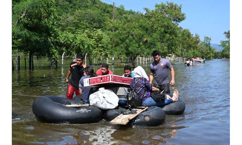
Residents evacuate a flooded area in Baracoa, Honduras on November 8, 2020
NOVEMBER 14, 2020
Honduras, Guatemala and Nicaragua announced evacuations Friday as a second major hurricane in days closed in on Central America with the region still reeling from deadly storm Eta last week.
Eta killed more than 200 people across Central America, with heavy rain bursting river banks and triggering landslides as far north as Chiapas, Mexico.
The US National Hurricane Center (NHC) in Miami has now confirmed that another major hurricane is approaching Honduras, Nicaragua and Guatemala, whose populations total more than 30 million.
The NHC forecasts Tropical Storm Iota to become a Category 2 or 3 hurricane as it moves into the same shell-shocked countries, hitting Nicaragua and Honduras by late Sunday or early Monday—less than two weeks after Eta hit.
Authorities in Honduras on Friday ordered the evacuation by police and the army of people in the area of San Pedro Sula—the country's second city and industrial capital, located 180 kilometers (110 miles) north of Tegucigalpa.
"Our red alert (in Honduras) orders mandatory evacuations," Julissa Mercado of Honduras' Emergency Response Agency told AFP.
The San Pedro Sula valley was hit hard by Eta and about 40,000 people are still in shelters across the country.
In Nicaragua relief agencies began to evacuate some indigenous communities from the Coco River, on the border with Honduras, which could be affected by heavy rains and floods due to the storm.
"We are asking you to calmly prepare" for the hurricane that "threatens to cause floods and disasters," Rose Cunnigham, the mayor of Waspam, on the border with Honduras, urged the community over a local radio station.
Waspam authorities on Friday sent boats to evacuate the community in Cabo Gracias a Dios, the cape where the Coco River flows into the Caribbean along the "Mosquito Coast", and buses to transport people from the village of Bihmuna.
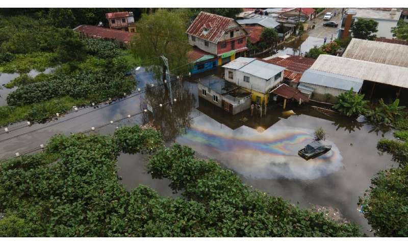
The town of Morales in Guatemala's Izabal Department is seen flooded following the passage of storm Eta on November 7, 2020
Guatemala's disaster management agency CONRED meanwhile called on residents in the country's most threatened areas in the north and northeast to voluntarily evacuate to shelters. It also recommended avoiding waterways and other risky areas.
"Our ground is already oversaturated," said Guatemala's President Alejandro Giammattei.
"So it's to be expected that we will have more farming and infrastructure damage," he warned after meeting his Honduran counterpart, Juan Orlando Hernandez, in Guatemala City.
Eta hit the Caribbean coast of Nicaragua as a Category 4 storm and was one of the strongest November storms ever recorded.
Warmer seas caused by climate change are making hurricanes stronger for longer after landfall, increasing the destruction they can wreak, scientists say.
Guatemala's Giammattei on Friday accused industrialized nations of being responsible for the catastrophes caused by climate change that are ravaging the area.
"Central America is one of the regions where climate change is felt the most," he told reporters.
The region is hit by "catastrophic floods, extreme droughts and the greatest poverty" but nonetheless receives "the least help on behalf of these industrialized nations", he said.
This year's hurricane season has seen a record 30 named tropical storms wreak havoc across the southeastern United States, the Caribbean and Central America.
The NHC was even forced to switch to the Greek alphabet after 2020's storms exhausted its list of Latin names.
Explore further Storm Eta leaves 150 dead or missing in Guatemala
© 2020 AFP
Hurricane Iota to deal another catastrophic blow to Central America
By Courtney Spamer, Accuweather.com & UPI Staff

Hurricane Iota strengthened into a Category 4 storm early Monday. Photo courtesy of NOAA
Nov. 16 (UPI) -- Areas of Central America still reeling from a humanitarian crisis caused by the deadly Hurricane Eta are now under threat from an equally powerful tropical system -- Hurricane Iota.
At 1 a.m. EST on Monday, the national Hurricane Center said Iota had strengthened into a Category 3 hurricane on the Saffir-Simpson Hurricane Wind Scale. Iota is the sixth major hurricane, meaning it is a Category 3 or higher, to churn in the Atlantic this season.
Just 40 minutes later, Iota was found to have rapidly strengthened into a dangerous Category 4 hurricane.
As of 1:40 a.m. EST Monday, Iota was packing a serious punch with sustained winds of 140 mph. Iota continued to move westward at 10 mph with its center located about 190 miles east-southeast of Cabo Gracias on the Nicaragua-Honduras border. Hurricane watches and warnings are in effect for much of the coast.
Besides Iota, the most recent major hurricane in the Atlantic was Hurricane Eta. Hurricane Eta made landfall as a Category 4 hurricane on Nov. 3, in Nicaragua, which was among the top five strongest storms to ever hit the nation. Eta also carved a path of destruction through Honduras and Guatemala, unleashing feet of rain, tremendous flooding and killing more than 100.
Central America is still facing a humanitarian crisis following Eta's deadly blow. Millions are enduring dangerous conditions in the storm's wake -- with concerns over waterborne diseases and COVID-19 complicating recovery. And the situation could become even more dire as Iota creeps toward the coast.
"With Eta having gone through less than 2 weeks ago, Hurricane Iota will place another devastating blow to the region. No amount of words can describe the problems this system will add to the crisis already occurring in the area," AccuWeather Senior Meteorologist Matt Rinde said.
Iota is forecast to pick up some forward speed and continue to move westward toward the border of Honduras and Nicaragua. Along the way, heavy rainfall will inundate northern Colombia and northwestern Venezuela, as well as southern Jamaica.
In addition to widespread rainfall, Iota will be moving through an area of low wind shear and warm water -- around 84 degrees Fahrenheit -- in the western Caribbean Sea, encouraging the hurricane to strengthen into an even more powerful hurricane.
"Exactly how long Iota is able to to hang out in that favorable environment will ultimately determine how long it could be a major [Category 3 or higher] hurricane," said AccuWeather Senior Meteorologist Rob Miller.
RELATED Subtropical Storm Theta makes 2020 a record year for named storms
The exact track it takes, the strength and forward speed as it plows onshore in Central America will determine how grim the situation will become.
"It is possible that Iota could track north of Honduras, allowing the areas hardest hit by Hurricane Eta to be spared. But it is even more likely that Honduras and Nicaragua take a direct hit from Iota," warned Miller.
Should Iota make landfall in Nicaragua as a hurricane, it would be only the second time in history the country would be hit by two hurricanes in one season. The last time it occurred was in 1971, when Hurricane Irene and Hurricane Edith hit Nicaragua.
In Central America, building seas will be the first impact, coming on Sunday. Next would be the outer bands of Iota, that will bring heavy rain to Nicaragua and eastern Honduras as early as Monday morning, then gusty winds.
The exact strength of Iota at landfall will dictate the wind gusts experienced by the storm. If Iota makes landfall as a Category 4 hurricane, with sustained winds of 130 mph or greater, the effects could be devastating.
In addition to the strongest, most distructive winds being found at the coast near landfall, so too will be the most impactful storm surge from Iota.
Storm surge of 1-3 feet will stretch from near Claura in Honduras to Haulover, Nicaragua, with the most severe surge, 10-15 feet (3-5 meters) between Puerto Cabezas and Nina Yari. This same area experienced coastal inundation from Eta earlier this month.
Even still, the most widespread and greatest threat to lives and property from the new cyclone is expected to be dealt by serious flooding caused by feet of rainfall. Major river flooding and flash flooding could occur with a vast area of 12-18 inches across the mountainous terrain of Honduras, the most likely location for the AccuWeather Local StormMax of 30 inches.
Even more widespread amounts of 2-4 inches are forecast from Guatemala to central Nicaragua, worsening ongoing flooding and clean-up efforts.
With all of the mountainous terrain and the very saturated ground following Hurricane Eta, mudslides are a definite concern with the new tropical threat.
Given the threat posed by devastating storm surge, catastrophic flooding inland and devastating winds, Iota will be a 5 on the AccuWeather RealImpact Scale for Hurricanes over Central America. This is based on the life-threatening heavy rainfall that will lead to catastrophic flooding, damaging winds, storm surge and a number of other economic factors.
Tropical Storm Iota developed Friday afternoon in the central Caribbean just hours after the system had become Tropical Depression 31. Iota strengthened into a hurricane early Sunday morning and officially became the 13th hurricane of the season. 2020 is now just two shy of the record number of hurricanes to churn in the Atlantic in one season held by 2005.
In fact, this is the first time the NHC has ever gotten this far into the Greek alphabet during a tropical season.
Iota strengthened into a Category 3 hurricane early Monday morning and officially became the sixth major hurricane of the season. Five other major hurricanes churned in the Atlantic this season: Laura, Teddy, Delta, Epsilon and Eta.
This year set the record for the most tropical storms to be named in one Atlantic hurricane season as Theta became the 29th tropical storm of the season earlier this week.
Theta continued to swirl in the Atlantic Basin on Saturday morning, after spinning between the Azores and Canary Islands into Sunday morni
By Courtney Spamer, Accuweather.com & UPI Staff
Hurricane Iota strengthened into a Category 4 storm early Monday. Photo courtesy of NOAA
Nov. 16 (UPI) -- Areas of Central America still reeling from a humanitarian crisis caused by the deadly Hurricane Eta are now under threat from an equally powerful tropical system -- Hurricane Iota.
At 1 a.m. EST on Monday, the national Hurricane Center said Iota had strengthened into a Category 3 hurricane on the Saffir-Simpson Hurricane Wind Scale. Iota is the sixth major hurricane, meaning it is a Category 3 or higher, to churn in the Atlantic this season.
Just 40 minutes later, Iota was found to have rapidly strengthened into a dangerous Category 4 hurricane.
As of 1:40 a.m. EST Monday, Iota was packing a serious punch with sustained winds of 140 mph. Iota continued to move westward at 10 mph with its center located about 190 miles east-southeast of Cabo Gracias on the Nicaragua-Honduras border. Hurricane watches and warnings are in effect for much of the coast.
Besides Iota, the most recent major hurricane in the Atlantic was Hurricane Eta. Hurricane Eta made landfall as a Category 4 hurricane on Nov. 3, in Nicaragua, which was among the top five strongest storms to ever hit the nation. Eta also carved a path of destruction through Honduras and Guatemala, unleashing feet of rain, tremendous flooding and killing more than 100.
Central America is still facing a humanitarian crisis following Eta's deadly blow. Millions are enduring dangerous conditions in the storm's wake -- with concerns over waterborne diseases and COVID-19 complicating recovery. And the situation could become even more dire as Iota creeps toward the coast.
"With Eta having gone through less than 2 weeks ago, Hurricane Iota will place another devastating blow to the region. No amount of words can describe the problems this system will add to the crisis already occurring in the area," AccuWeather Senior Meteorologist Matt Rinde said.
Iota is forecast to pick up some forward speed and continue to move westward toward the border of Honduras and Nicaragua. Along the way, heavy rainfall will inundate northern Colombia and northwestern Venezuela, as well as southern Jamaica.
In addition to widespread rainfall, Iota will be moving through an area of low wind shear and warm water -- around 84 degrees Fahrenheit -- in the western Caribbean Sea, encouraging the hurricane to strengthen into an even more powerful hurricane.
"Exactly how long Iota is able to to hang out in that favorable environment will ultimately determine how long it could be a major [Category 3 or higher] hurricane," said AccuWeather Senior Meteorologist Rob Miller.
RELATED Subtropical Storm Theta makes 2020 a record year for named storms
The exact track it takes, the strength and forward speed as it plows onshore in Central America will determine how grim the situation will become.
"It is possible that Iota could track north of Honduras, allowing the areas hardest hit by Hurricane Eta to be spared. But it is even more likely that Honduras and Nicaragua take a direct hit from Iota," warned Miller.
Should Iota make landfall in Nicaragua as a hurricane, it would be only the second time in history the country would be hit by two hurricanes in one season. The last time it occurred was in 1971, when Hurricane Irene and Hurricane Edith hit Nicaragua.
In Central America, building seas will be the first impact, coming on Sunday. Next would be the outer bands of Iota, that will bring heavy rain to Nicaragua and eastern Honduras as early as Monday morning, then gusty winds.
The exact strength of Iota at landfall will dictate the wind gusts experienced by the storm. If Iota makes landfall as a Category 4 hurricane, with sustained winds of 130 mph or greater, the effects could be devastating.
In addition to the strongest, most distructive winds being found at the coast near landfall, so too will be the most impactful storm surge from Iota.
Storm surge of 1-3 feet will stretch from near Claura in Honduras to Haulover, Nicaragua, with the most severe surge, 10-15 feet (3-5 meters) between Puerto Cabezas and Nina Yari. This same area experienced coastal inundation from Eta earlier this month.
Even still, the most widespread and greatest threat to lives and property from the new cyclone is expected to be dealt by serious flooding caused by feet of rainfall. Major river flooding and flash flooding could occur with a vast area of 12-18 inches across the mountainous terrain of Honduras, the most likely location for the AccuWeather Local StormMax of 30 inches.
Even more widespread amounts of 2-4 inches are forecast from Guatemala to central Nicaragua, worsening ongoing flooding and clean-up efforts.
With all of the mountainous terrain and the very saturated ground following Hurricane Eta, mudslides are a definite concern with the new tropical threat.
Given the threat posed by devastating storm surge, catastrophic flooding inland and devastating winds, Iota will be a 5 on the AccuWeather RealImpact Scale for Hurricanes over Central America. This is based on the life-threatening heavy rainfall that will lead to catastrophic flooding, damaging winds, storm surge and a number of other economic factors.
Tropical Storm Iota developed Friday afternoon in the central Caribbean just hours after the system had become Tropical Depression 31. Iota strengthened into a hurricane early Sunday morning and officially became the 13th hurricane of the season. 2020 is now just two shy of the record number of hurricanes to churn in the Atlantic in one season held by 2005.
In fact, this is the first time the NHC has ever gotten this far into the Greek alphabet during a tropical season.
Iota strengthened into a Category 3 hurricane early Monday morning and officially became the sixth major hurricane of the season. Five other major hurricanes churned in the Atlantic this season: Laura, Teddy, Delta, Epsilon and Eta.
This year set the record for the most tropical storms to be named in one Atlantic hurricane season as Theta became the 29th tropical storm of the season earlier this week.
Theta continued to swirl in the Atlantic Basin on Saturday morning, after spinning between the Azores and Canary Islands into Sunday morni
No comments:
Post a Comment