Kate Nicholson
Sun, 21 January 2024

The UK is blanketed by "unusual" danger-to-life wind warnings ahead of Storm Isha.
Storm Isha is on its way – but, as the ninth named storm the UK has faced since summer ended, why are meteorologists calling it “unusual”?
Why is Isha a ‘rare’ storm?
The UK has seen plenty of storms recently, particularly named ones – after all, Storm Henk was only earlier this month.
If a storm has been named, it means they pose a threat to life.
The Met Office names them in alphabetically order. Isha is the ninth storm of the winter season (which technically begins in September) so it is named after the ninth letter.
The Met Office has explained that storm was triggered by the subsiding of the cold Arctic air which had been hanging over the UK – meaning air from the Atlantic came in.
The weather has therefore become much milder in temperature, but it’s much wetter and windier, too.
And that’s why meteorologists keep saying Isha is of particular interest – the UK does not often see storms which see the whole country hit by weather warnings.
According to Sky News, Met Office forecaster Ellie Glaisyer said that the “main thing” about Isha is that it is “very widespread” – and it’s “relatively rare” to have the whole of the UK covered by a warning.
“That’s the main difference to previous storms we have seen,” she said.
Channel 4 weather presenter Liam Dutton echoed this, writing on X (formerly Twitter): “Storm Isha is unusual because the disruptive winds cover a very large area.”
What weather will Isha bring?
The Met Office has already issued an amber weather warning for wind for the north and south-west of England, Wales, large parts of Northern Ireland and central and southern Scotland, from Sunday into Monday.
Another warning will be introduced for Sussex and Kent from Monday morning.
Winds of up to 80mph are expected along the UK coasts, and many places will see gusts of 50-60mph inland.
There’s a risk to life in coastal areas, and yellow flood warnings are expected for the next two days.
Ireland’s meteorological service, Met Eireann, has also introduced amber wind warnings for Sunday, which will escalate into a red storm warning for coastal areas in the north of the country on Monday.
Amber means there’s a good chance of power cuts, and other services could be impacts. Buildings may be damaged, journeys may be lengthened or cancelled altogether and some roads and bridges may close.
It also means injuries and danger to life likely from large waves and beach material thrown onto coastal roads, sea fronts and property.
A red weather warning means people need to seek cover and protect themselves or their properties.
A yellow wind warning will be in place covering Northern Ireland, north Wales, northern England and much of Scotland from Tuesday until midday on Wednesday.
The winds will gradually east throughout Monday, and overnight it should be a “calmer interlude” according to the Met Office – although it will be wet and windy again on Tuesday.
Five dead as Storm Isha brings winds of 107mph
ITV News reports from up and down the country as winds surpass 100mph in some areas
Monday 22 January 2024

Five people have died across the UK and Ireland as Storm Isha continues to cause disruption, leaving thousands without power.
Gales reached over 100mph in places after wind warnings were issued by the Met Office on Monday.
Transport Scotland said a gust of 107mph was recorded on the Tay Bridge, while the Met Office is recording the highest wind speed as 99mph at Brizlee Wood in Northumberland.
The bad weather has caused a series of fatal accidents, including a man reportedly falling into an exposed manhole Bradford.

Severe travel disruption as trains and flights cancelled
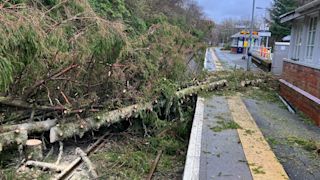
Storm Jocelyn is coming hot on the heels of Storm Isha
Meanwhile, an 84-year-old man died after riding as a passenger in a car that crashed into a fallen tree in Grangemouth, Falkirk, on Sunday, Police Scotland have said.
He was sat in front seat and was declared dead at the scene, the force confirmed. The other occupants of the Hyundai were not injured.
First Minister Humza Yousaf paid tribute to the man, and warned of further disruption from the upcoming Storm Jocelyn.
Commuters were warned that ScotRail services would stop at 7pm on Tuesday, with no rush hour services on Wednesday morning – the second cancellation this week.
A 60-year-old man died in a road collision involving two vans and a fallen tree in Limavady, County Londonderry.
The Police Service of Northern Ireland has confirmed the man was killed on Sunday.
In Ireland, two people have died in separate road incidents. A man in his 40s died in Mayo on Sunday after a storm-related car crash.
A woman in her 20s, who was a passenger in a van, also died after it hit a tree in Co Louth at 1.50am on Monday.
Multiple other people have been taken to hospital with serious injuries as a result of the storm.
It comes as the powerful storm swept in on Sunday battering the UK and Ireland and causing forecasters to enforce "unusual" danger-to-life wind warnings, with concerns a tornado may hit parts of Britain.
A number of weather warnings, including two amber wind alerts, were put in place by the Met Office across the UK, with a Status Red wind warning issued for several Republic of Ireland counties.
The next storm due to hit the UK and Ireland has been named by the Irish Meteorological Service as Storm Jocelyn, which is expected to cause strong winds from Tuesday night into Wednesday morning.
CCTV footage from Lincolnshire shows the moment a roof is ripped from a house and narrowly misses a moving car
Rail, air and sea travel disruption
Rail, sea and air travellers are facing significant disruption, with closures, cancellations and delays across a number of services after Storm Isha tore through the UK.
Rush-hour trains have been axed for many on Monday after the storm battered parts of the country, bringing warnings of possible tornadoes and danger-to-life winds.
Network Rail says routes continue to be impacted by Storm Isha after previously imposing 50mph speed restrictions to keep passengers and trains safe from falling trees and debris blown onto tracks.
Severe travel disruption as trains and flights cancelled
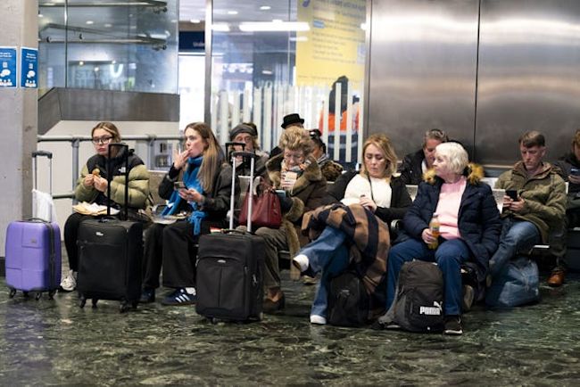
Meanwhile, air traffic control restrictions were in place, leading to flight cancellations and causing some planes to divert.
In Scotland, the Irish Sea and the English Channel many ferry trips have been cancelled.
Power blackouts, flying debris and fallen trees as weather warnings continue
Northern Ireland Electricity Networks said 45,000 customers were without power, while Electricity North West also said thousands of properties in north-west England had lost their supply.
Widespread power cuts in the Republic of Ireland were affecting more than 170,000 properties.
Fallen trees have affected transport, with Traffic Scotland reporting stretches of the M9 and M74 were among roads closed throughout the night, while the A1 southbound was closed at Thorntonloch due to an overturned lorry.
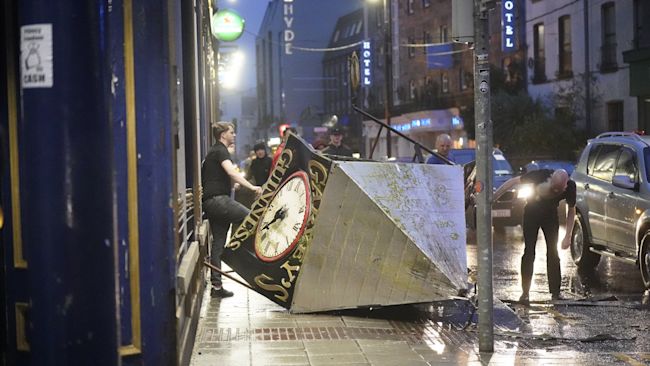
The Met Office has said “everybody” will be affected by the storm, while ITV Weather's Manali Lukha said it is "really unusual to see the whole country covered in wind warnings".
According to the forecaster, the highest recorded wind speed during Storm Isha was 99mph at Brizlee Wood in Northumberland, with gusts of 90mph at Capel Curig in Snowdonia on Sunday.
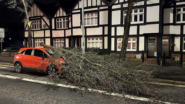
Transport Scotland said a gust of 107mph was recorded on the Tay Bridge and the Met Office said there was one of 84mph at Salsburgh, North Lanarkshire.
A rare red warning for wind in north-east Scotland was in place until 5am on Monday, with amber warnings covering much of the UK until 6am and further yellow warnings covering the entire country until noon.
A further yellow warning for wind for Scotland, Northern Ireland, north Wales and northern England is active from 4pm on Tuesday until noon on Wednesday.
Heavy downpours battered some places, with 28 flood warnings in place in England and 50 in Scotland.

Why is the UK experiencing so many named storms?
Storm Isha is the ninth named storm to hit the UK since the season began in September.
Each storm is named when it poses a risk to people and they are given names beginning with consecutive letters of the alphabet.
The record number of named storms in one year is when the Met Office began the practice in 2015-16, with Storm Katie being the 11th and final storm of the season.
If there are three more named storms between next week and August, this year will mark a new record.
Cold Arctic air pushing south into North America is making the jet stream more active, the Met Office said, and because it flows from west to east, it is bringing stormier weather to the UK.


