Doyle Rice, USA TODAY
Updated Thu, September 28, 2023
Let the dance begin.
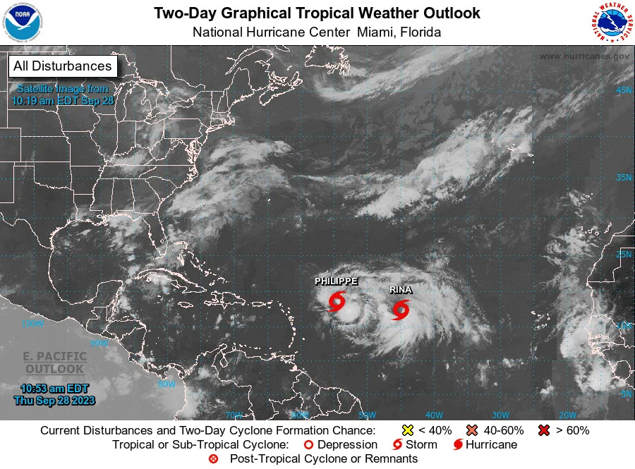
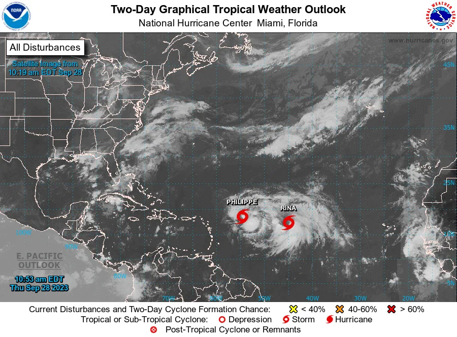
Tropical Storm Rina formed Thursday morning in the Atlantic Ocean, not far from Tropical Storm Philippe. Forecasters from the National Hurricane Center say the two systems might begin to interact with one another as they spin in the open ocean far from land, in a complex dance − almost like a square dance − known as the Fujiwhara Effect.
According to meteorologist Matt Lanza's blog The Eyewall, "the two systems would track close enough to one another to impact each other’s track." In this case, Philippe would likely slow, stall, or get pushed to the south since it’s ahead of Rina, and Rina would basically slingshot over the top of Philippe either west or northwest and out to sea, he said.
Miami-based meteorologist John Morales, writing on X, said the two storms are now separated by less than 700 miles and that "they're expected to pivot around each other, with one becoming more dominant. Now, neither is expected to hit the Caribbean."
What is the Fujiwhara Effect?
Basically, the Fujiwhara Effect describes the rotation of two storms around each other. It's most common with tropical cyclones such as typhoons or hurricanes, but it also occurs in other cases.
When two hurricanes spinning in the same direction pass close enough to each other, they begin an intense dance around their common center, the National Weather Service said.
The effect is thought to occur when storms get about 900 miles apart.
Square dancing and ice skaters
Storms involved in the Fujiwhara Effect are rotating around one another as if they had locked arms and were square dancing. Rather than each storm spinning about the other, they are actually moving about a central point between them, as if both were tied to the same post and each swung around it separately from the other.
A good way to picture this is to think of two ice skaters who skate quickly toward each other, nearly on a collision course, grab hands as they are about to pass and spin vigorously around in one big circle with their joined hands at the center.
The effect is named after Dr. Sakuhei Fujiwhara who was the chief of the Central Meteorological Bureau in Tokyo shortly after the first World War. In 1921, he wrote a paper describing the motions of "vortices" in water. Water vortices, such as whirlpools, are little water whirls that spin around.
What is the path of Philippe and Rina?
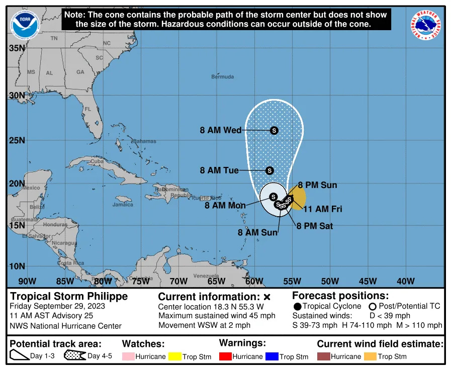
The National Hurricane Center, in its 5 p.m. ET forecast discussion for Tropical Storm Philippe, said that its "trackforecast is challenging, in part due to Philippe's close proximity to Tropical Storm Rina." During the next few days, Philippe will likely move slowly southwestward as it rotates around Rina currently to its east, the hurricane center said.
As of Thursday evening, the center of Philippe was located 525 miles east of the northern Leeward islands. It had winds of 45 mph and was crawling along at 2 mph.
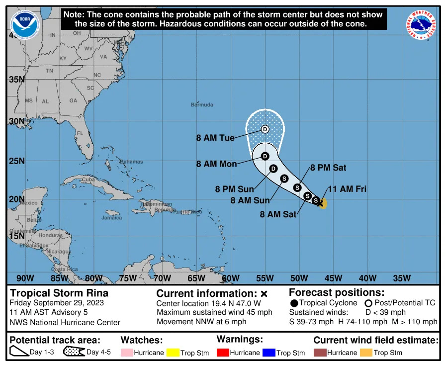
As for Rina, the tropical storm is moving northwestward, with a forward speed near 14 mph. Rina "should begin to turn more westward today and continue this general motion for the next several days."
"Confidence in the track forecast (for Rina) is lower than normal based on the model spread and uncertainty regarding the potential interaction with Tropical Storm Philippe during the next several days," the hurricane center said.
No coastal watches or warnings are in effect for either storm, and there were no hazards affecting land.
The National Hurricane Center, in its 5 p.m. ET forecast discussion for Tropical Storm Philippe, said that its "trackforecast is challenging, in part due to Philippe's close proximity to Tropical Storm Rina." During the next few days, Philippe will likely move slowly southwestward as it rotates around Rina currently to its east, the hurricane center said.
As of Thursday evening, the center of Philippe was located 525 miles east of the northern Leeward islands. It had winds of 45 mph and was crawling along at 2 mph.
As for Rina, the tropical storm is moving northwestward, with a forward speed near 14 mph. Rina "should begin to turn more westward today and continue this general motion for the next several days."
"Confidence in the track forecast (for Rina) is lower than normal based on the model spread and uncertainty regarding the potential interaction with Tropical Storm Philippe during the next several days," the hurricane center said.
No coastal watches or warnings are in effect for either storm, and there were no hazards affecting land.
Track Tropical Storm Philippe
Rina is the 18th storm of the season
Tropical Storm Rina is the 18th Atlantic named storm of the 2023 Atlantic hurricane season, said Colorado State University research meteorologist Phil Klotzbach, on X. "That's the 3rd-most on record through September 28, trailing 2020 (23 named storms) and 2021 (19 named storms)."
Tropical Storm Rina is the 18th Atlantic named storm of the 2023 Atlantic hurricane season, said Colorado State University research meteorologist Phil Klotzbach, on X. "That's the 3rd-most on record through September 28, trailing 2020 (23 named storms) and 2021 (19 named storms)."
Track Tropical Storm Rina
Tropical Storm Rina forms, could mix with Tropical Storm Philippe, hurricane center says
Richard Tribou, Orlando Sentinel
Updated Thu, September 28, 2023
Orlando Sentinel/TNS
A slowing Tropical Storm Philippe might end up mixing with the newly formed Tropical Storm Rina in the coming days, according to the National Hurricane Center.
As of 11 a.m. the NHC said Philippe was located about 560 miles east of the Caribbean’s northern Leeward Islands moving west-northwest at 2 mph with maximum sustained winds of 50 mph.
“A slow westward or southwestward motion is expected during the next few days,” forecasters said. “Little change in strength is forecast during the next few days.”
Tropical-storm-force winds extend out up to 175 miles.
The storm’s slowing forward movement gives uncertainty to the forecast, with the latest five-day cone of uncertainty projecting it will avoid a direct path over the Caribbean islands, and a shift to the north. Its sluggishness puts it in a potential path to mix with the season’s latest named storm, Tropical Storm Rina.
“A complicating factor to this track forecast is the proximity of an area of disturbed weather to the east of the cyclone,” forecasters said. “Some models are still showing a binary interaction between the two systems, which will largely depend on the strength of each.”
The NHC began advisories on Tropical Storm Rina at 11 a.m. Thursday.
It was located about 1,190 miles east of the northern Leewards moving north-northwest at 10 mph with maximum sustained winds of 40 mph. Tropical-storm-force winds extend out 60 miles.
“The storm is expected to turn more westward later today or tomorrow,” forecasters said. “Some gradual strengthening is forecast during the next few days.”
Forecasters said persistent shear and its close proximity and uncertain interaction with Tropical Storm Philippe should limit intensification, so it is not expected to form into a hurricane.
“Confidence in the track forecast is lower than normal based on the model spread and uncertainty regarding the potential interaction with Tropical Storm Philippe during the next several days,” forecasters said.
The 2023 Atlantic hurricane season is now ranked third for storm formation through Sept. 28, according to hurricane expert Philip Klotzbach with Colorado State University.
While only the 17th storm with a designated name, 2023 also had an unnamed 18th subtropical storm in January.
It trails only the 23 named storms seen by this date in 2020, and the 19 seen by this date in 2021. 2020 ended up with a record-tying 31 systems that year, which was also seen in 2005, with both years forming several storms in October and November. 2021 ended up with 21 systems for the year.
The hurricane season runs through Nov. 30.
Philippe drifts northwest as odds remain high for new system to form
Robin Webb, Angie DiMichele, Bill Kearney, South Florida Sun-Sentinel
Thu, September 28, 2023
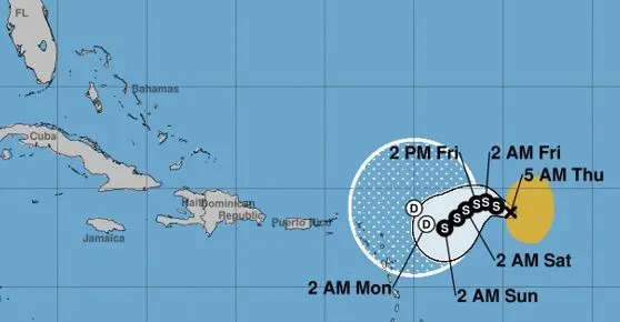
Tropical Storm Philippe is expected to drift for the next few days as it nears the Caribbean, though it may curve and skirt that boundary. Following to the east, a second system is highly likely to strengthen into a tropical depression, or possibly Tropical Storm Rina.
The National Hurricane Center expects some slight fluctuations in intensity as Philippe moves west-northwest or west. It’s unclear at this point if the storm will maintain its tropical cyclone status if it reaches the northern Leeward Islands, or if it will weaken by that point. In general, forecasters anticipate an overall slow weakening trend later this weekend and weekend as the storm continues to encounter storm-shredding wind shear and dry air.
Tropical-storm-force winds from Philippe, which extend outward up to 175 miles from its center, could begin arriving in northern Caribbean islands as early as Friday, including Anguilla and the U.S. and British Virgin Islands, according to the National Hurricane Center.
From Friday to Monday, Philippe could produce 2 to 4 inches of rain across the islands of the northeastern Caribbean, the Virgin Islands and eastern Puerto Rico. Western Puerto Rico could see 1 to 2 inches of rain. Areas hardest hit by rainfall could see isolated urban and small stream flooding.
As of 5 a.m. Thursday, Philippe was located about 560 miles east of the far eastern Caribbean, moving west-northwest at 5 mph. Its maximum sustained winds are holding steady at 50 mph.
The system that could soon become a tropical depression or tropical storm was located about halfway between the Cabo Verde Islands off Africa and the far eastern Caribbean and had a 90% chance of developing within two to seven days, the hurricane center said as of 2 a.m. Thursday.
Its showers and thunderstorms had become more concentrated, and forecasters said conditions are favorable for it to develop if it stays far enough away from Philippe to its west. The hurricane center said it is expected to become a tropical depression or storm in about a day or so and will move northwest across the Atlantic.
So far this season in the Atlantic, there have been 16 named storms, six of which were hurricanes. Of those, three were major hurricanes, meaning Category 3 or above.
Those were Hurricane Lee, a rare Category 5; Hurricane Franklin, a Category 4; and Hurricane Idalia, which made landfall on Florida’s Big Bend region at Category 3 strength on Aug. 30.
Hurricane season officially runs through Nov. 30.
What is the Fujiwhara Effect?
Aaron Barker
Thu, September 28, 2023
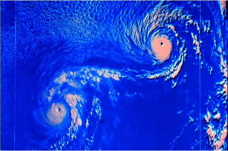
Hurricanes are among the most intense weather systems on the planet. When two tropical cyclones get too close for comfort, a delicate dance can happen and lead to some unusual things.
Meteorologists call this tropical tango the Fujiwhara Effect. It happens when two tropical cyclones get close enough to each other to create a shared center, forcing the two storms to whip around that common central point.
If one of the storms is stronger than the other, the effect usually leads to the weaker one being gobbled up by the more powerful cyclone. If the storms are similar in strength, they can sometimes merge or just slingshot around each other and continue on their way. On rare occasions, the storms can combine into a larger storm, according to the National Weather Service.
BRYAN NORCROSS DISCUSSES POSSIBILITY OF FUJIWHARA EFFECT HAPPENING WITH PHILIPPE, RINA

A demonstration of the three scenarios typically seen during the Fujiwhara Effect.
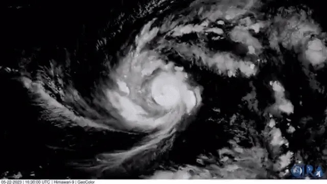
This lesson in physics was demonstrated by Super Typhoon Hinnamnor in 2022 in the Pacific Ocean. Hinnamnor devoured a weaker tropical low that was near it.
The video below shows how Hinnamnor, indicated by the hurricane symbol, pulled the weaker tropical cyclone, indicated by the L symbol, toward it. Eventually, the hurricane overpowered the weaker storm and absorbed it.
According to NOAA, the cyclones need to be between 350 and 860 miles of each other to begin rotating around their common center. That distance is dependent on the size of the storms.
Bryan Norcross: More than meets the eye to new study about tropical cyclones
Aaron Barker
Thu, September 28, 2023
Hurricanes are among the most intense weather systems on the planet. When two tropical cyclones get too close for comfort, a delicate dance can happen and lead to some unusual things.
Meteorologists call this tropical tango the Fujiwhara Effect. It happens when two tropical cyclones get close enough to each other to create a shared center, forcing the two storms to whip around that common central point.
If one of the storms is stronger than the other, the effect usually leads to the weaker one being gobbled up by the more powerful cyclone. If the storms are similar in strength, they can sometimes merge or just slingshot around each other and continue on their way. On rare occasions, the storms can combine into a larger storm, according to the National Weather Service.
BRYAN NORCROSS DISCUSSES POSSIBILITY OF FUJIWHARA EFFECT HAPPENING WITH PHILIPPE, RINA
A demonstration of the three scenarios typically seen during the Fujiwhara Effect.
This lesson in physics was demonstrated by Super Typhoon Hinnamnor in 2022 in the Pacific Ocean. Hinnamnor devoured a weaker tropical low that was near it.
The video below shows how Hinnamnor, indicated by the hurricane symbol, pulled the weaker tropical cyclone, indicated by the L symbol, toward it. Eventually, the hurricane overpowered the weaker storm and absorbed it.
According to NOAA, the cyclones need to be between 350 and 860 miles of each other to begin rotating around their common center. That distance is dependent on the size of the storms.
Bryan Norcross: More than meets the eye to new study about tropical cyclones
Angeli Gabriel
Wed, September 27, 2023 at 5:39 PM MDT·2 min read
FOX Weather hurricane specialist Bryan Norcross breaks down the complex tropical cyclone data used in a recently published study in Nature.
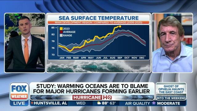
Titled "Seasonal advance of intense tropical cyclones in a warming climate," the study states that intense tropical cyclones have been occurring earlier than usual in most tropical oceans since the 1980s. Researchers said this phenomenon is largely driven by the warming effects of greenhouse gas forcing.
The study has gained much attention in the weather news space, including some outlets stating that this year’s active hurricane season in the Atlantic is demonstrative of the study’s findings.
However, Norcross analyzed the study and said there are a few aspects to consider.
New satellite images show powerful Super Typhoon Mawar approaching the U.S. island territory of Guam.
He notes that first, the study has a global perspective. This means that it includes data about hurricanes, which are tropical cyclones in the Atlantic, along with typhoons and other tropical cyclones of different names around the world. He said that much of what the study covers involved tropical cyclones on the western side of the Pacific Ocean.
5 DIFFERENT NAMES FOR HURRICANES AROUND THE WORLD
Also, the time period of the data set used ranges from 1981 to 2017, which introduces a couple of complexities. According to Norcross, this period of 36 years includes half of a suppressed hurricane era and about half of an enhanced hurricane era.
"That suppressed area was caused by air pollution coming from Europe, kind of shielding the Atlantic Ocean we know now," he said. "So, that's not in the picture now."
Because of this, the upward trend that seems apparent in the data set from the 1980s appears to be influenced by the exceptionally lower numbers of hurricanes in the Atlantic, as caused by European air pollution.
Whether this year’s active hurricane season in the Atlantic is demonstrative of the global tropical cyclone activity remains to be seen.
Tropical cyclone activity occurs throughout the year around the world, according to the State Department. The Atlantic hurricane season runs from June through November, cyclones in the South Pacific Ocean and Indian Ocean typically occur between November and April and typhoon season in the Northwest Pacific Ocean runs from April through December.
Original article source: Bryan Norcross: More than meets the eye to new study about tropical cyclones
Wed, September 27, 2023 at 5:39 PM MDT·2 min read
FOX Weather hurricane specialist Bryan Norcross breaks down the complex tropical cyclone data used in a recently published study in Nature.
Titled "Seasonal advance of intense tropical cyclones in a warming climate," the study states that intense tropical cyclones have been occurring earlier than usual in most tropical oceans since the 1980s. Researchers said this phenomenon is largely driven by the warming effects of greenhouse gas forcing.
The study has gained much attention in the weather news space, including some outlets stating that this year’s active hurricane season in the Atlantic is demonstrative of the study’s findings.
However, Norcross analyzed the study and said there are a few aspects to consider.
New satellite images show powerful Super Typhoon Mawar approaching the U.S. island territory of Guam.
He notes that first, the study has a global perspective. This means that it includes data about hurricanes, which are tropical cyclones in the Atlantic, along with typhoons and other tropical cyclones of different names around the world. He said that much of what the study covers involved tropical cyclones on the western side of the Pacific Ocean.
5 DIFFERENT NAMES FOR HURRICANES AROUND THE WORLD
Also, the time period of the data set used ranges from 1981 to 2017, which introduces a couple of complexities. According to Norcross, this period of 36 years includes half of a suppressed hurricane era and about half of an enhanced hurricane era.
"That suppressed area was caused by air pollution coming from Europe, kind of shielding the Atlantic Ocean we know now," he said. "So, that's not in the picture now."
Because of this, the upward trend that seems apparent in the data set from the 1980s appears to be influenced by the exceptionally lower numbers of hurricanes in the Atlantic, as caused by European air pollution.
Whether this year’s active hurricane season in the Atlantic is demonstrative of the global tropical cyclone activity remains to be seen.
Tropical cyclone activity occurs throughout the year around the world, according to the State Department. The Atlantic hurricane season runs from June through November, cyclones in the South Pacific Ocean and Indian Ocean typically occur between November and April and typhoon season in the Northwest Pacific Ocean runs from April through December.
Original article source: Bryan Norcross: More than meets the eye to new study about tropical cyclones
No comments:
Post a Comment