UK
Winter snow warning as Polar Vortex threatens most savage December for 11 years
Story by Nathan Rao • Yesterday
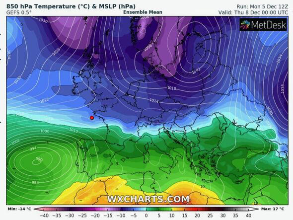
Government forecasters have issued the first cold weather alert of the season amid warnings this week for dangerous Arctic air spreading over the UK. Temperatures could plummet to -15C in the Highlands of Scotland ahead of the weekend while up to four inches of snow is forecast for the region.
VIDEO
Duration 2:43
View on Watch
Britons have been urged to 'take action' to prepare for the cold blast, which threatens to hold out until mid-December.
Jim Dale, a meteorologist for British Weather Services, said: "This is not about panicking, but being ready and prepared in the run-up to Christmas.
"It is important to make sure you are stocked up for the cold weather to prevent a panic when it happens.
"This is especially important this close to Christmas and with other factors that could leave shelves not very well stocked during the cold period."
Freezing temperatures and heavy snowfall in parts later this week will lead to icy pavements and dangerous driving conditions, he warned.
He said: "There will be hazards in parts of the country in terms of snowfall and ice on the roads and pavements.
"This will bring the risk of slipping and will make for dangerous driving conditions.
"The key is to be prepared for if this comes off and do things a little bit ahead of time."
‘Polar Vortex' threatens most savage December freeze for more than a decade
Winter snow warning as Polar Vortex threatens most savage December for 11 years
Story by Nathan Rao • Yesterday
Government forecasters have issued the first cold weather alert of the season amid warnings this week for dangerous Arctic air spreading over the UK. Temperatures could plummet to -15C in the Highlands of Scotland ahead of the weekend while up to four inches of snow is forecast for the region.
VIDEO
Duration 2:43
View on Watch
Britons have been urged to 'take action' to prepare for the cold blast, which threatens to hold out until mid-December.
Jim Dale, a meteorologist for British Weather Services, said: "This is not about panicking, but being ready and prepared in the run-up to Christmas.
"It is important to make sure you are stocked up for the cold weather to prevent a panic when it happens.
"This is especially important this close to Christmas and with other factors that could leave shelves not very well stocked during the cold period."
Freezing temperatures and heavy snowfall in parts later this week will lead to icy pavements and dangerous driving conditions, he warned.
He said: "There will be hazards in parts of the country in terms of snowfall and ice on the roads and pavements.
"This will bring the risk of slipping and will make for dangerous driving conditions.
"The key is to be prepared for if this comes off and do things a little bit ahead of time."
‘Polar Vortex' threatens most savage December freeze for more than a decade
© WX Charts
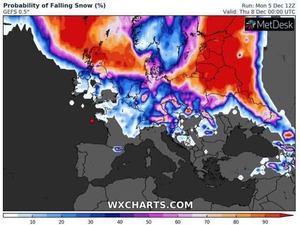
Snow risk this week© WX Charts
Northern Scotland is braced for blizzards on Wednesday to dump up to four inches of snow across the region
The Met Office has issued a severe weather warning across Grampian, the Highlands, Orkney and Shetland, and Central Tayside and Fife.
Severe cold weather could hamper railway services and other travel networks while triggering delays on the roads.
Elderly and vulnerable people have been warned to take extra care while others have been urged to keep an eye on neighbours as the cold strikes.
The Met Office with the UK Health Security Agency (UKHSA) has issued a level three 'severe weather action' alert which will stay in force between Wednesday and the start of next week.
Dr Agostinho Sousa, consultant in public health medicine at UKHSA, said: "Cold weather can have serious consequences for health, and older people and those with heart or lung conditions can be particularly at risk.
"If you have a pre-existing medical condition, you should heat your home to a temperature that is comfortable for you."
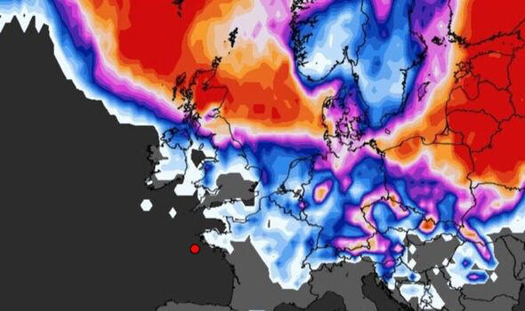
Polar vortex moves across the UK© WX Charts
Met Office deputy chief meteorologist Rebekah Sherwin added: "Temperatures will start to dip this week, with daytime temperatures struggling to get above freezing in many places from mid-week onwards.
"However, the cold air from the Arctic will also bring brighter conditions, with some dry, sunny spells in many areas, particularly away from the coast."
Keep-fitters with underlying health conditions are warned to take extra care exercising in extreme cold.
Health and wellness coach Ryan French, founder of Military Outdoor Fitness (MOFit), based in London, Greenwich, said: "Training in cold weather, as in very hot weather, does carry some risk, so it is important to prepare.
"This is especially true of people with asthma because studies show cold weather can increase bronchoconstriction-a narrowing of the airways.
"If you are training outside in the cold weather, make sure to have your inhaler to hand."
As temperatures plummet, bookies have once more slashed the odds on festive snow with Ladbrokes offering 11-10 from 6-4 on a White Christmas.
Spokesman Alex Apati said: "White Christmas punters look set to get their wish this year, if the latest odds are anything to go by."
Netweather meteorologist Nick Finnis warned a 'chunk of the tropospheric Polar vortex' will 'drip south towards the UK bringing Arctic air'.
He said: "A chunk of the tropospheric polar vortex will push out from the Arctic southwards over Scandinavia and the Norwegian Sea before moving across Britain later [this] week.
"Winds will turn northerly by mid-week and will introduce colder air from the arctic across all parts through the second half of the week."
Exacta Weather's James Madden added: "In addition to the snow, it is also going to become exceptionally cold and widespread frosts will develop across the whole country and deliver problems/warnings for ice in places from midweek.
"This will also allow the fallen snow to persist in many places while temperatures drop as low as -10C or lower in the coldest spots."
The last time Britain was hit by heavy snow in December was 2010 which also brought the last widespread White Christmas.
Snow risk this week© WX Charts
Northern Scotland is braced for blizzards on Wednesday to dump up to four inches of snow across the region
The Met Office has issued a severe weather warning across Grampian, the Highlands, Orkney and Shetland, and Central Tayside and Fife.
Severe cold weather could hamper railway services and other travel networks while triggering delays on the roads.
Elderly and vulnerable people have been warned to take extra care while others have been urged to keep an eye on neighbours as the cold strikes.
The Met Office with the UK Health Security Agency (UKHSA) has issued a level three 'severe weather action' alert which will stay in force between Wednesday and the start of next week.
Dr Agostinho Sousa, consultant in public health medicine at UKHSA, said: "Cold weather can have serious consequences for health, and older people and those with heart or lung conditions can be particularly at risk.
"If you have a pre-existing medical condition, you should heat your home to a temperature that is comfortable for you."
Polar vortex moves across the UK© WX Charts
Met Office deputy chief meteorologist Rebekah Sherwin added: "Temperatures will start to dip this week, with daytime temperatures struggling to get above freezing in many places from mid-week onwards.
"However, the cold air from the Arctic will also bring brighter conditions, with some dry, sunny spells in many areas, particularly away from the coast."
Keep-fitters with underlying health conditions are warned to take extra care exercising in extreme cold.
Health and wellness coach Ryan French, founder of Military Outdoor Fitness (MOFit), based in London, Greenwich, said: "Training in cold weather, as in very hot weather, does carry some risk, so it is important to prepare.
"This is especially true of people with asthma because studies show cold weather can increase bronchoconstriction-a narrowing of the airways.
"If you are training outside in the cold weather, make sure to have your inhaler to hand."
As temperatures plummet, bookies have once more slashed the odds on festive snow with Ladbrokes offering 11-10 from 6-4 on a White Christmas.
Spokesman Alex Apati said: "White Christmas punters look set to get their wish this year, if the latest odds are anything to go by."
Netweather meteorologist Nick Finnis warned a 'chunk of the tropospheric Polar vortex' will 'drip south towards the UK bringing Arctic air'.
He said: "A chunk of the tropospheric polar vortex will push out from the Arctic southwards over Scandinavia and the Norwegian Sea before moving across Britain later [this] week.
"Winds will turn northerly by mid-week and will introduce colder air from the arctic across all parts through the second half of the week."
Exacta Weather's James Madden added: "In addition to the snow, it is also going to become exceptionally cold and widespread frosts will develop across the whole country and deliver problems/warnings for ice in places from midweek.
"This will also allow the fallen snow to persist in many places while temperatures drop as low as -10C or lower in the coldest spots."
The last time Britain was hit by heavy snow in December was 2010 which also brought the last widespread White Christmas.
USA
Monstrous storm could bring tornadoes, blizzard conditions to central US next weekStory by Alex Sosnowski • TODAY
A much more dynamic and volatile weather pattern is looming for the United States as the atmosphere begins to shift gears following a quieter start to December. By early next week, numerous small, weak disturbances will be replaced by one massive storm that could wreak havoc on cross-country travel as well as pose a significant threat to lives and property, AccuWeather meteorologists warn.
"The stage is being set for extreme weather conditions over the U.S. next week, especially for the middle of the nation," AccuWeather Chief On-Air Meteorologist Bernie Rayno said.

Monstrous storm could bring tornadoes, blizzard conditions to central US next week
© Provided by AccuWeather
The orientation of the jet stream will play a big factor in the development of the major storm.
This week's weather will feature impacts from a series of weak storms that will deliver drenching rain from the south-central region to the Atlantic coast and stripes of snow from the Rockies to the Upper Midwest and interior Northeast.
One of the foundational pieces of next week's storm was located thousands of miles west of North America on Wednesday. A large storm loaded with moisture over the northern Pacific was forecast to swing toward Alaska late this week then southeastward toward the western United States this weekend.

Monstrous storm could bring tornadoes, blizzard conditions to central US next week© Provided by AccuWeather
From this weekend to next week, the jet stream will change from its current nearly west-to-east configuration to a very convoluted setup that favors at least one major storm.
The first phase of that storm will unfold this weekend, as it brings a substantial amount of rain to coastal areas and lower elevations and mountain snow to the Pacific coast. As the storm then moves across the Rockies, it will remain potent before it eventually reorganizes into a monstrous system by early next week over the Great Plains and Mississippi Valley.
As warm and moist air begins to flow northward from the Gulf of Mexico, shifting and strengthening winds above the ground to the jet stream level will spark powerful thunderstorms over portions of the South Central states during the first part of next week.
As warm and moist air begins to flow northward from the Gulf of Mexico, shifting and strengthening winds above the ground to the jet stream level of the atmosphere will spark powerful thunderstorms over portions of the South Central states during the first part of next week.


Winter Storm Prompts Blizzard Warnings In Northern Plains
The Weather Channel
"Not only is there likely to be an outbreak of severe thunderstorms with this [weather pattern], but multiple tornadoes are possible," Rayno said. "The setup could bring a greater number of tornadoes, compared to last week's outbreak in the Southern states as it seems there will be just too much energy available in the atmosphere for that not to occur."

Monstrous storm could bring tornadoes, blizzard conditions to central US next week© Provided by AccuWeather
There is a significant chance of tornadoes to be on the ground from Tuesday afternoon to Tuesday night over portions of the interstate 20, 30, 40 and 55 corridors, Rayno added.
Severe thunderstorms could occur west of the I-55 corridor late Monday and may extend well to the east from the Great Lakes to the Tennessee Valley on Wednesday.
Outside of severe thunderstorms, the surging moisture can produce locally heavy rain in parts of the same area. While the downpours are likely to bring yet another boost to river levels on the Mississippi and Ohio rivers, too much rain may fall too fast for small streams and artificial drainage systems to handle, which could result in some flooding around urban areas.
The dynamic storm will have a cold and wintry side as well.
Frigid air that has been hovering over south-central Canada for days will be pulled southward by the strengthening storm.
As this cold air is injected into the storm, a zone of high winds and heavy snow will unfold from portions of the central Rockies to the northern Plains from the early to the middle part of next week

Monstrous storm could bring tornadoes, blizzard conditions to central US next week© Provided by AccuWeather
An all-out blizzard will likely unfold in at least part of the zone from Colorado to the Dakotas and northern Minnesota from Tuesday to Wednesday, Rayno said.
"Portions of the North Central states could be dealing with a doozy of a storm," AccuWeather Long-Range Meteorologist Brandon Buckingham said. "Moisture that is transported from the Gulf of Mexico all the way to the northern Plains by next Tuesday should be impressive."
The cold component of the storm will result in windswept, powdery snow with accumulation totals ranging from inches to a foot or more. Extensive blowing and drifting and difficult-to-impossible travel conditions in portions of the interstate 29, 90 and 94 corridors could occur.
But even as the storm pivots inland from the Pacific Ocean later this weekend to early next week, areas of heavy snow will break out in portions of Nevada, Arizona, Utah, New Mexico, Idaho, Colorado and Wyoming. Travel via interstates 15, 25, 40 70 and 80 could be adversely affected.

Monstrous storm could bring tornadoes, blizzard conditions to central US next week© Provided by AccuWeather
Strong winds from the storm will also develop in portions of the Southwest and the southern High Plains. These winds could kick up dust, raise the wildfire danger and lead to vehicle rollovers on area highways.
AccuWeather forecasters say where the worst conditions in terms of snow and severe weather, including tornadoes, will occur will be determined by how quickly the storm strengthens and the track it eventually takes. AccuWeather's team of meteorologists will continue to examine the latest weather data available and refine forecasts as needed in the coming days.
Another risk forecasters will be exploring in association with the upcoming massive central U.S. storm will be the possibility of a spin-off or secondary storm later next week along the Atlantic coast. This potential storm could also produce its own zone of gusty winds, heavy rain and inland pockets of ice and snow.
"Not only is there likely to be an outbreak of severe thunderstorms with this [weather pattern], but multiple tornadoes are possible," Rayno said. "The setup could bring a greater number of tornadoes, compared to last week's outbreak in the Southern states as it seems there will be just too much energy available in the atmosphere for that not to occur."
Monstrous storm could bring tornadoes, blizzard conditions to central US next week© Provided by AccuWeather
There is a significant chance of tornadoes to be on the ground from Tuesday afternoon to Tuesday night over portions of the interstate 20, 30, 40 and 55 corridors, Rayno added.
Severe thunderstorms could occur west of the I-55 corridor late Monday and may extend well to the east from the Great Lakes to the Tennessee Valley on Wednesday.
Outside of severe thunderstorms, the surging moisture can produce locally heavy rain in parts of the same area. While the downpours are likely to bring yet another boost to river levels on the Mississippi and Ohio rivers, too much rain may fall too fast for small streams and artificial drainage systems to handle, which could result in some flooding around urban areas.
The dynamic storm will have a cold and wintry side as well.
Frigid air that has been hovering over south-central Canada for days will be pulled southward by the strengthening storm.
As this cold air is injected into the storm, a zone of high winds and heavy snow will unfold from portions of the central Rockies to the northern Plains from the early to the middle part of next week
Monstrous storm could bring tornadoes, blizzard conditions to central US next week© Provided by AccuWeather
An all-out blizzard will likely unfold in at least part of the zone from Colorado to the Dakotas and northern Minnesota from Tuesday to Wednesday, Rayno said.
"Portions of the North Central states could be dealing with a doozy of a storm," AccuWeather Long-Range Meteorologist Brandon Buckingham said. "Moisture that is transported from the Gulf of Mexico all the way to the northern Plains by next Tuesday should be impressive."
The cold component of the storm will result in windswept, powdery snow with accumulation totals ranging from inches to a foot or more. Extensive blowing and drifting and difficult-to-impossible travel conditions in portions of the interstate 29, 90 and 94 corridors could occur.
But even as the storm pivots inland from the Pacific Ocean later this weekend to early next week, areas of heavy snow will break out in portions of Nevada, Arizona, Utah, New Mexico, Idaho, Colorado and Wyoming. Travel via interstates 15, 25, 40 70 and 80 could be adversely affected.
Monstrous storm could bring tornadoes, blizzard conditions to central US next week© Provided by AccuWeather
Strong winds from the storm will also develop in portions of the Southwest and the southern High Plains. These winds could kick up dust, raise the wildfire danger and lead to vehicle rollovers on area highways.
AccuWeather forecasters say where the worst conditions in terms of snow and severe weather, including tornadoes, will occur will be determined by how quickly the storm strengthens and the track it eventually takes. AccuWeather's team of meteorologists will continue to examine the latest weather data available and refine forecasts as needed in the coming days.
Another risk forecasters will be exploring in association with the upcoming massive central U.S. storm will be the possibility of a spin-off or secondary storm later next week along the Atlantic coast. This potential storm could also produce its own zone of gusty winds, heavy rain and inland pockets of ice and snow.
No comments:
Post a Comment