Here's what it means for weather in the US.

Doyle Rice, USA TODAY
Fri, September 9, 2022
La Niña just won't go away.
Meteorologists say that for the third straight year, La Niña will persist throughout the winter in the Northern Hemisphere. This is the first "triple-dip" La Niña of the century, according to a recent update from the United Nations' World Meteorological Organization.
This La Niña began in September 2020.
The La Niña climate pattern is a natural cycle marked by cooler-than-average ocean water in the central Pacific Ocean. It is one of the main drivers of weather in the United States and around the world, especially during late fall, winter and early spring.
It's the opposite to the more well-known El Niño, which occurs when Pacific ocean water is warmer than average. While this would be the first "triple-dip" La Niña this century, it's not unprecedented for the pattern to last more than nine months to a year, which is typical for a La Niña, according to ABC News.
What is La Niña?: Does it bring more snow? How climate pattern could affect US weather.
Yosemite in peril: How climate change’s grip is altering America’s national parks
A new normal? Climate change exposes growing gap between weather we've planned for – and what's coming
What does La Niña mean for winter in the US?
A typical La Niña winter in the U.S. brings cold and snow to the Northwest and unusually dry conditions to most of the southern tier of the U.S., according to NOAA's Climate Prediction Center. The Southeast and Mid-Atlantic also tend to see warmer-than-average temperatures during a La Niña winter.
Meanwhile, New England and the Upper Midwest into New York tend to see colder-than-average temperatures, the Weather Channel said.
Climate change also plays a role
However, the WMO said all naturally occurring climate events now take place in the context of human-induced climate change, which is increasing global temperatures, exacerbating extreme weather and climate, and impacting seasonal rainfall and temperature patterns.
“It is exceptional to have three consecutive years with a La Niña event," said WMO Secretary-General Petteri Taalas in a news release. "Its cooling influence is temporarily slowing the rise in global temperatures – but it will not halt or reverse the long-term warming trend,” he added.
Where did the term La Niña come from?
Both La Niña and El Niño are Spanish language terms: La Niña means "little girl," while El Niño means "little boy," or "Christ child." South American fishermen first noticed periods of unusually warm water in the Pacific Ocean in the 1600s, the National Oceanic and Atmospheric Administration said. The full name they used was "El Niño de Navidad" because El Niño typically peaks around December.
The entire natural climate cycle is officially known by climate scientists as El Niño – Southern Oscillation (ENSO), a see-saw dance of warmer and cooler seawater in the central Pacific Ocean.
During La Niña events, trade winds are even stronger than usual, pushing more warm water toward Asia, NOAA said. Off the west coast of the Americas, upwelling increases, bringing cold, nutrient-rich water to the surface.
This article originally appeared on USA TODAY: 'Triple-dip' La Niña forecast: What does that mean for US weather?
La Nina winter 2022-23 could mean tornado outbreaks, blizzards and everything in between
Do you remember the last two winters? Well, if forecasts for a rare-triple dip La Niña are accurate, the country is in store for more weather extremes.
The National Oceanic and Atmospheric Administration released an updated outlook Thursday that said there was a 91 percent chance the pattern would be in control through November and a 54 percent chance through March 2023.
A substantial amount of cooler-than-average water in the east-central Pacific and long-range climate models give forecasters confidence that the La Niña pattern will continue.
FARMERS’ ALMANAC DECLARES PARTS OF US ‘HIBERNATION ZONE’ WITH PREDICTED ‘GLACIAL, SNOW-FILLED’ WINTER
During a typical La Niña winter, the southern tier of the country tends to be drier and warmer, and the northern half is usually colder and snowier than usual.
Where moisture and temperature extremes meet, areas can resemble battle zones. If the right ingredients are in place, tornado outbreaks can impact the South and the country’s heartland.
"Preliminary research indicates that La Niña corresponds to an especially active phase for tornadoes over the Deep South with a relatively high frequency of cold-season outbreaks of EF2 or stronger tornadoes," the National Weather Service office in Jackson, Mississippi, said.
The combination of an active jet stream, plenty of moisture and a clash of air masses helped produce a record-breaking deadly tornado outbreak in December 2021. The outbreak included a rare EF-4 long-track tornado that flatted parts of Mayfield, Kentucky.
HOW SALMON NUMBERS RISE AND FALL DURING EL NINO AND LA NINA
On the other side of the spectrum, snowstorms and blizzards are usually common where deep moisture meets frigid air.
Communities from Maine through the Plains and to the Pacific Northwest reported record-breaking snowfall events during the past winter and there is nothing in the outlook that says the extreme events won’t happen in the northern tier again.
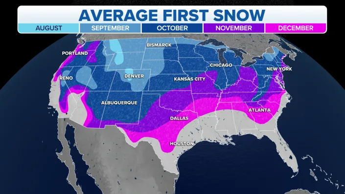
Average date of the first snowfall of the season.
NOAA’s Climate Prediction Center believes the La Niña three-peat will be only the third time on record for the occurrence.
Usually, the El Niño-Southern Oscillation, or what is commonly called the ENSO, tends to act more seesaw-like, flipping between La Niña and El Niño more frequently.
Long-term model guidance shows high chances of La Niña drastically waning during the spring.
A diminishing La Niña would put the world in neutral status until ocean temperatures and complex pressure patterns decide the future of the state of the ENSO.

NOAA ENSO Forecast showing the possibilities of La Nina, El Nino and neutral status.
Doyle Rice, USA TODAY
Fri, September 9, 2022
La Niña just won't go away.
Meteorologists say that for the third straight year, La Niña will persist throughout the winter in the Northern Hemisphere. This is the first "triple-dip" La Niña of the century, according to a recent update from the United Nations' World Meteorological Organization.
This La Niña began in September 2020.
The La Niña climate pattern is a natural cycle marked by cooler-than-average ocean water in the central Pacific Ocean. It is one of the main drivers of weather in the United States and around the world, especially during late fall, winter and early spring.
It's the opposite to the more well-known El Niño, which occurs when Pacific ocean water is warmer than average. While this would be the first "triple-dip" La Niña this century, it's not unprecedented for the pattern to last more than nine months to a year, which is typical for a La Niña, according to ABC News.
What is La Niña?: Does it bring more snow? How climate pattern could affect US weather.
Yosemite in peril: How climate change’s grip is altering America’s national parks
A new normal? Climate change exposes growing gap between weather we've planned for – and what's coming
What does La Niña mean for winter in the US?
A typical La Niña winter in the U.S. brings cold and snow to the Northwest and unusually dry conditions to most of the southern tier of the U.S., according to NOAA's Climate Prediction Center. The Southeast and Mid-Atlantic also tend to see warmer-than-average temperatures during a La Niña winter.
Meanwhile, New England and the Upper Midwest into New York tend to see colder-than-average temperatures, the Weather Channel said.
Climate change also plays a role
However, the WMO said all naturally occurring climate events now take place in the context of human-induced climate change, which is increasing global temperatures, exacerbating extreme weather and climate, and impacting seasonal rainfall and temperature patterns.
“It is exceptional to have three consecutive years with a La Niña event," said WMO Secretary-General Petteri Taalas in a news release. "Its cooling influence is temporarily slowing the rise in global temperatures – but it will not halt or reverse the long-term warming trend,” he added.
Where did the term La Niña come from?
Both La Niña and El Niño are Spanish language terms: La Niña means "little girl," while El Niño means "little boy," or "Christ child." South American fishermen first noticed periods of unusually warm water in the Pacific Ocean in the 1600s, the National Oceanic and Atmospheric Administration said. The full name they used was "El Niño de Navidad" because El Niño typically peaks around December.
The entire natural climate cycle is officially known by climate scientists as El Niño – Southern Oscillation (ENSO), a see-saw dance of warmer and cooler seawater in the central Pacific Ocean.
During La Niña events, trade winds are even stronger than usual, pushing more warm water toward Asia, NOAA said. Off the west coast of the Americas, upwelling increases, bringing cold, nutrient-rich water to the surface.
This article originally appeared on USA TODAY: 'Triple-dip' La Niña forecast: What does that mean for US weather?
La Nina winter 2022-23 could mean tornado outbreaks, blizzards and everything in between
Do you remember the last two winters? Well, if forecasts for a rare-triple dip La Niña are accurate, the country is in store for more weather extremes.
The National Oceanic and Atmospheric Administration released an updated outlook Thursday that said there was a 91 percent chance the pattern would be in control through November and a 54 percent chance through March 2023.
A substantial amount of cooler-than-average water in the east-central Pacific and long-range climate models give forecasters confidence that the La Niña pattern will continue.
FARMERS’ ALMANAC DECLARES PARTS OF US ‘HIBERNATION ZONE’ WITH PREDICTED ‘GLACIAL, SNOW-FILLED’ WINTER
During a typical La Niña winter, the southern tier of the country tends to be drier and warmer, and the northern half is usually colder and snowier than usual.
Where moisture and temperature extremes meet, areas can resemble battle zones. If the right ingredients are in place, tornado outbreaks can impact the South and the country’s heartland.
"Preliminary research indicates that La Niña corresponds to an especially active phase for tornadoes over the Deep South with a relatively high frequency of cold-season outbreaks of EF2 or stronger tornadoes," the National Weather Service office in Jackson, Mississippi, said.
The combination of an active jet stream, plenty of moisture and a clash of air masses helped produce a record-breaking deadly tornado outbreak in December 2021. The outbreak included a rare EF-4 long-track tornado that flatted parts of Mayfield, Kentucky.
HOW SALMON NUMBERS RISE AND FALL DURING EL NINO AND LA NINA
On the other side of the spectrum, snowstorms and blizzards are usually common where deep moisture meets frigid air.
Communities from Maine through the Plains and to the Pacific Northwest reported record-breaking snowfall events during the past winter and there is nothing in the outlook that says the extreme events won’t happen in the northern tier again.
Average date of the first snowfall of the season.
NOAA’s Climate Prediction Center believes the La Niña three-peat will be only the third time on record for the occurrence.
Usually, the El Niño-Southern Oscillation, or what is commonly called the ENSO, tends to act more seesaw-like, flipping between La Niña and El Niño more frequently.
Long-term model guidance shows high chances of La Niña drastically waning during the spring.
A diminishing La Niña would put the world in neutral status until ocean temperatures and complex pressure patterns decide the future of the state of the ENSO.
NOAA ENSO Forecast showing the possibilities of La Nina, El Nino and neutral status.
No comments:
Post a Comment