It hasn't been a lake for a century. An atmospheric river just made it one again
Tue November 30, 2021
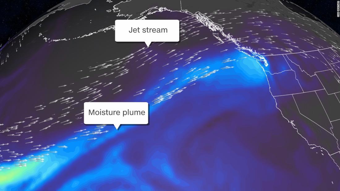
(CNN)Another atmospheric river will be streaming into western Washington and parts of British Columbia, Canada, this week.
While back-to-back-to-back systems for the region seem a bit like a broken record lately, the phenomenon is truly significant.
Rivers in the sky have led to landslides blocking roads, rivers inundating towns, and in one case, returning an old lake bed back into a lake.
British Columbia typically sees atmospheric river events in the month of November, just as the Pacific Northwest does. The problem for both regions this year has been the consistency of the systems, with no breaks for drying in between.
"The first atmospheric river event hit us hard on November 13 to 16, and it dumped a lot, 150-300 mm (roughly 6 to 11 inches), of precipitation in less than 48 hours," Johnson Zhong, a meteorologist for Environment Canada said.
There has also been rain on top of fresh snow, which has exacerbated flooding.
"There was up to 30-50 cm (1-1.5 feet) of fresh snow at 1500-2500 meters (5,000-8,000 feet) high," he observed. "One of our atmospheric river events rained much higher than 2500 meters, so that rain melted the snow and helped create the flooding."
One of the areas seeing the greatest amount of flooding was the Sumas area, about 50 miles east of Vancouver.
"One hundred years ago there was a Sumas lake. Then they pumped the water out to make good farmland. It has been farmland for the last 100 years, and now it's a lake again," Zhong explained.
He added more than half of the egg and dairy supply for Vancouver come from that farmland, which has hit the region exceptionally hard.
The unprecedented amount of rain has created major flooding, washing out bridges and roads, completely cutting off many other small Canadian towns to the rest of the world.
Merritt, British Columbia, is one of those towns.
"Merritt is a town of 7,000 people and is totally flooded," Zhong said. "That town is in an area that doesn't get a lot of rain. But with the combination of rain and snowmelt, the entire town flooded. The water and sewage system went down, and the entire town had to be evacuated."
British Columbia has suffered a great deal since the summer months.
They endured a relentless heatwave that gripped the entire region and killed nearly 600 people.
They also experienced wildfires that completely wiped the town of Lytton off the map.
Fresh burn scars from the wildfires are also making the flooding and mudslide potential worse, Zhong pointed out.
Mudslides and landslides are a major concern for both British Columbia and Washington.
"Persistent rainfall over the last few weeks has dramatically increased soil moisture to high levels across western Washington," the National Weather Service (NWS) office in Seattle reported. "Heavy rainfall of an additional 1 to 3 inches in the mountains and up to 1.5 inches in the lowlands has fallen over the last 24 hours. Therefore, the increased threat of landslides will continue through today despite the heaviest rainfall coming to an end."
In the Seattle area, which is soaked as well, they hope all the rain doesn't come at once.
Seattle is experiencing its wettest fall on record. The Seattle-Tacoma airport has recorded 18.91 inches of rain for September through November, and more is on the way.
By Tuesday, the month could end as one of the top wettest Novembers on record. With an additional 2 to 3 inches of rain expected to fall, more flooding is Inevitable.
"The big factor that will affect the scope of expected impacts will be how much of a break we receive in areas where river flooding continues today," the NWS in Seattle emphasized.
The Nooksack and Skagit Rivers, north of Seattle, are still rising and have yet to crest, so more rainfall on top of already rising rivers could create major flooding issues for nearby towns.
"It remains unclear how rivers in these areas will respond to additional rainfall over the next 2 days," NWS Seattle added.
Climate Impact on atmospheric rivers
Marty Ralph, director of the Center for Western Weather and Water Extremes at the Scripps Institution of Oceanography in San Diego, said the climate crisis may be intensifying atmospheric rivers in the West.
"Warmer atmospheric temperatures, in general, will mean the freezing levels are higher than they've been in the past," Ralph told CNN. "But while storms vary, even without climate change and some can be extra warm, just by natural situation, it's clear the background warming should increase the [freezing] levels."
Ralph explained a higher freezing level, the altitude at which rain transitions to snow, can be dangerous with a wet landscape and full rivers.
"This makes for extra potential potency to the impact," he said. "The rivers are already high again, so this one's going to pack a wallop."
Warmer air can also hold more water vapor, which fuels atmospheric rivers. Ralph noted as the atmosphere gets warmer due to climate change, the intensity of storms will likely increase and become more hazardous.
"As a scientist, my role is to help raise awareness that the situation is looking to be like a strong to extreme [atmospheric river], and the implications of that are for additional heavy rain and — given the situation on land — flooding," he said. "People should really look to their normal weather information provider for hazardous situations for specific guidance on what to do, because it seems to me that this is a pretty serious situation."

No comments:
Post a Comment