SCHADENFREUDE
More snow in forecast for Greater Victoria, wind chill values near -20 C for parts of Island
As snow continues to fall throughout parts of Vancouver Island with multiple warnings in effect for freezing temperatures, snowfall, and hazardous highway conditions, police are advising drivers stay of the roads if possible.
While the snow may be good news for people enjoying snow sports and children looking to toboggan, Saanich police reported “degrading road conditions” throughout the capital region this morning, creating less-than-ideal driving conditions.
“Avoid driving unless necessary as icy roads and snow continue to build up on all roadways,” advised Saanich Const. Spencer Loverock.
Environment Canada updated an Arctic outflow warning early Sunday for Greater Victoria and eastern Vancouver Island forecasting wind chill values as low as -20 C — near record cold temperatures — today through Wednesday.
An Arctic ridge of high pressure over the B.C. Interior will bring “strong and bitterly cold outflow winds” to coastal communities beginning tonight, said the national weather forecaster. The outflow winds will create wind chill values of -20 and lower. Mainland inlets and areas are more likely to experience these very cold wind chill values.
Environment Canada also issued a snowfall warning advising that an “unstable air mass” and colder outflow winds will bring further accumulations of up to five centimetres of snow throughout Greater Victoria and the Gulf Islands. That warning was lifted just before 11 a.m. Even greater amounts could fall on the east coast from Duncan to Nanaimo, where the warning remains in effect.
The weather forecaster is advising Islanders to adjust their driving as “rapidly accumulating snow will make travel difficult.” Another 5 cm of snow is forecast to fall over the Malahat portion of the Trans-Canada Highway from Goldstream to Mill Bay.
Drive B.C. has issued a winter driving advisories for Highway 14 between Metchosin and Sooke, the Trans-Canada between Chemainus and Mill Bay, and the Malahat. Travel is not recommended unless absolutely necessary.
Several B.C. Transit routes in Greater Victoria have detours due to the snow.
The Victoria Harbour Cats baseball team, on its official Twitter page, offered to get vulnerable seniors, fans and supporters, to essential destinations using its four-wheel-drive vehicle.
More than 1,000 B.C. Hydro customers in the central Island were without power early Sunday morning. By 10 a.m., that number was down to about 340 customers around Courtenay, Nanaimo, and Qualicum Beach.
Cold weather prompted the opening of a warming centre in Victoria at the James Bay United Church at 511 Michigan St. from 8:30 a.m. to 7:30 p.m. starting Christmas Day until Dec. 29.
An emergency warming centre has also been opened in Campbell River. It will operate from 8 p.m. to 8 a.m. nightly until Dec. 30.
Meanwhile, bird lovers are reminding residents with hummingbird feeders to keep them filled and unfrozen. The B.C. SPCA advises feeders that are left empty or left to freeze can lead to starvation for the birds that have come to rely on them.
“If you commit to winter feeding, you must commit fully," says the SPCA website. Non-migratory hummingbirds may come to rely on this food source and will suffer if it is interrupted.
In current freezing temperatures, its advised to bring your feeder in overnight to prevent freezing and put it back out first thing in the morning or alternate between two feeders.
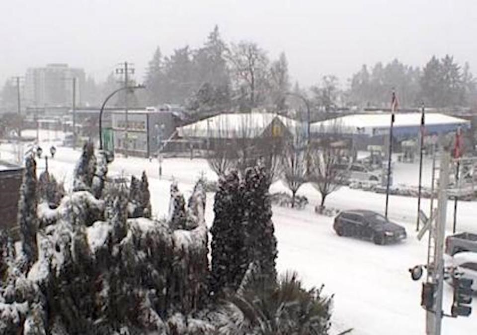
Metro Vancouver wakes up to a 'White Christmas' — in pictures
It was a rare snowy Christmas Day morning around Metro
Vancouver

Several ducks are seen swimming in a Vancouver park on Christmas Day
alongside a family enjoying the snow with their dog. (Enzo Zanatta/CBC)

An Anna's hummingbird is pictured sitting on a snowy stem in Richmond, B.C. on Christmas Day. (Submitted by Richard Topping)

A pond in a Vancouver park is seen flanked by snow-blanketed trees. (Enzo Zanatta/CBC)
By Elizabeth McSheffrey Global News
Posted December 26, 2021
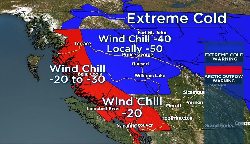
Environment Canada has issued warnings for extreme cold, winter storms, snowfall and chilly Arctic winds for much of the province.

A “bitterly cold airmass” has settled over the B.C. Interior, the federal agency said Sunday, warning that overnight lows could range between minus 30C and minus 50C with the wind chill.
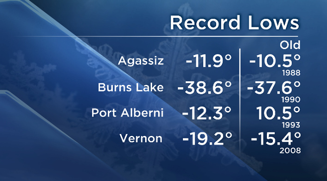
Records were broken in Agassiz, Burns Lake, Port Alberni and Vernon on Sunday, with temperatures of minus 11.9C, minus 38.6C, minus 12.3C and minus 19.2C, respectively.
Vernon made the greatest leap — it’s previous record for Dec. 26 was minus 15.4 in 2008.
Some parts of B.C. have already shattered records for the coldest Dec. 26 on record. Global News
READ MORE: Flooding, fires and heat: A year of unprecedented weather extremes in B.C.
Extreme cold warnings are in effect for the Cariboo region, 100 Mile area, Peace River region, Cassiar Mountains, and Bulkley Valley and the Lakes District.
A warning has also been issued for Fort Nelson, Williston, Yellowhead, McGregor, Prince George, Watson Lake, the Muncho Lake and Stone Mountain parks, and Stuart-Nechako region.
The cold will last until Monday morning, Environment Canada forecasts, with some moderation in temperature on Monday afternoon.

Meanwhile, Arctic wind warnings have been issued for the Central Coast regions, East Vancouver Island, Greater Victoria, the Howe Sound area, Metro Vancouver, the Sunshine Coast, and Fraser Valley.
Wind chills below minus 20C are expected between Sunday night and Wednesday, with “near record temperatures” early in the week, said Environment Canada.
The City of Vancouver has released a list of facilities with shelter space, including the Langara YMCA, Cascades and Tenth churches, the Evelyne Saller Centre, and the Bud Osborn EWR.
On Sunday, temperatures were 10C below the seasonal average for Vancouver with a high of minus 4C and a wind chill of minus 13C.
The winter conditions also prompted a series of travel advisories and road closures throughout the province, along with ferry cancellations in Upper Arrow Lake on Sunday morning.
Via DriveBC, the Ministry of Transportation is discouraging non-essential travel on several portions of Highways 1, 14, 17 and 3.
A snowfall warning of up to four centimetres has also been issued for East Vancouver Island.
No comments:
Post a Comment