Powerful winds to wallop B.C.'s South Coast in aftermath of Vancouver tornado
Meteorologists issued wind warnings for Lower Mainland,
one day after rare waterspout caused damage at UBC

Meteorologists issued heavy wind warnings for the Lower Mainland and other parts of B.C.'s coast on Sunday, one day after a rare waterspout was spotted over the ocean near Vancouver International Airport, bringing fierce winds to the UBC campus.
The winds toppled trees, blocked roads and disrupted transit on Saturday evening, sparking cleanup efforts and a brief tornado alert from Environment and Climate Change Canada.
The alert lasted only 24 minutes before the funnel cloud vanished, but the incident came amid a very windy weekend in the region, with worse conditions on the way.
Winds are forecast to reach at least 80 km/h starting Monday in Metro Vancouver, and are expected to reach 110 km/h on other parts of the B.C. coast, warned a special weather statement issued Sunday,
'It's scary'
Laura De Pascale was heading home from the UBC Fencing Club with a friend on Saturday when they saw lightning.
"Then it started pouring hail," she recalled. "There was just a bunch of swirling branches and leaves.
"And suddenly, I don't think I fully realized at the time, I didn't even notice the tree that fell behind my car."
She said the strong winds caused a trolley line to break and fall right outside her car door.
"Once you have power lines starting to come down on your car, it's scary," she said.
De Pascale and her friends were able to head home without injury but it's not an event she will soon forget.
"I still feel a bit of disbelief and it's hard not to think about what could have gone wrong."
No injuries have been reported from Saturday's weather event. Several people recorded videos of the waterspout, a tornado that forms above water, and posted them to social media.
Bus routes affected by downed trolley lines
TransLink said trolley repair likely won't begin until Monday morning, as arborists aren't expected to finish the clean-up of fallen trees and debris until late Sunday evening.
That means regular bus service may not commence until Tuesday.
Routes 004 and 014 will continue to use West 16th Avenue to reach the campus, while the 99 bus will use Chancellor Boulevard, Tina Lovgreen, spokesperson for TransLink, said in an emailed statement.
Winds picked up across Metro Vancouver over the weekend, with other parts of the region seeing downed trees and branches unrelated to the tornado.
Meteorologists continue to analyze the phenomenon that descended over UBC on Saturday around 5 p.m., but it's not the first time B.C.'s coast has seen a funnel cloud.
"Waterspouts can occur over the Strait of Georgia or other coastal waters throughout the year — it's not actually all that uncommon. However, this one was quite a large one," Bobby Sekhon, a federal meteorologist with Environment and Climate Change Canada, told CBC News.
"Seeing it close to land is a little bit more rare, especially moving through land … certainly close to populated centres."
Sekhon said it was caused by a "broad trough" of low pressure, with cold air atop warm air, creating an "unstable environment" combined with "spin" in the atmosphere on Saturday.
"Those ingredients kind of came together and formed this waterspout," he said.
And although the phenomenon is not unprecedented in this region, this one was rare for its size — and how close it got to a major city.
He said winds in funnel clouds can hit 80 to 100 km/h or more, but this one did not register on local weather stations.
Sekhon said the chances of another waterspout or tornado are very slight.
"Any time you see a funnel or even worse, a tornado, over water or over land it can be life-threatening — there can be strong wind speeds," Sekhon said. "You want to stay away from anything that might be flying around."
With files from Nadia Jannif
'Ultra-rare' November tornado hits
Vancouver, B.C., damage reported
Sunday, November 7th 2021, 9:52 pm - Witnesses in Vancouver, B.C., captured video and photos of a tornado over the Strait of Georgia Saturday that reportedly came ashore and caused minor tree damage at the University of British Columbia (UBC) and immediate vicinity. No injuries have been reported.
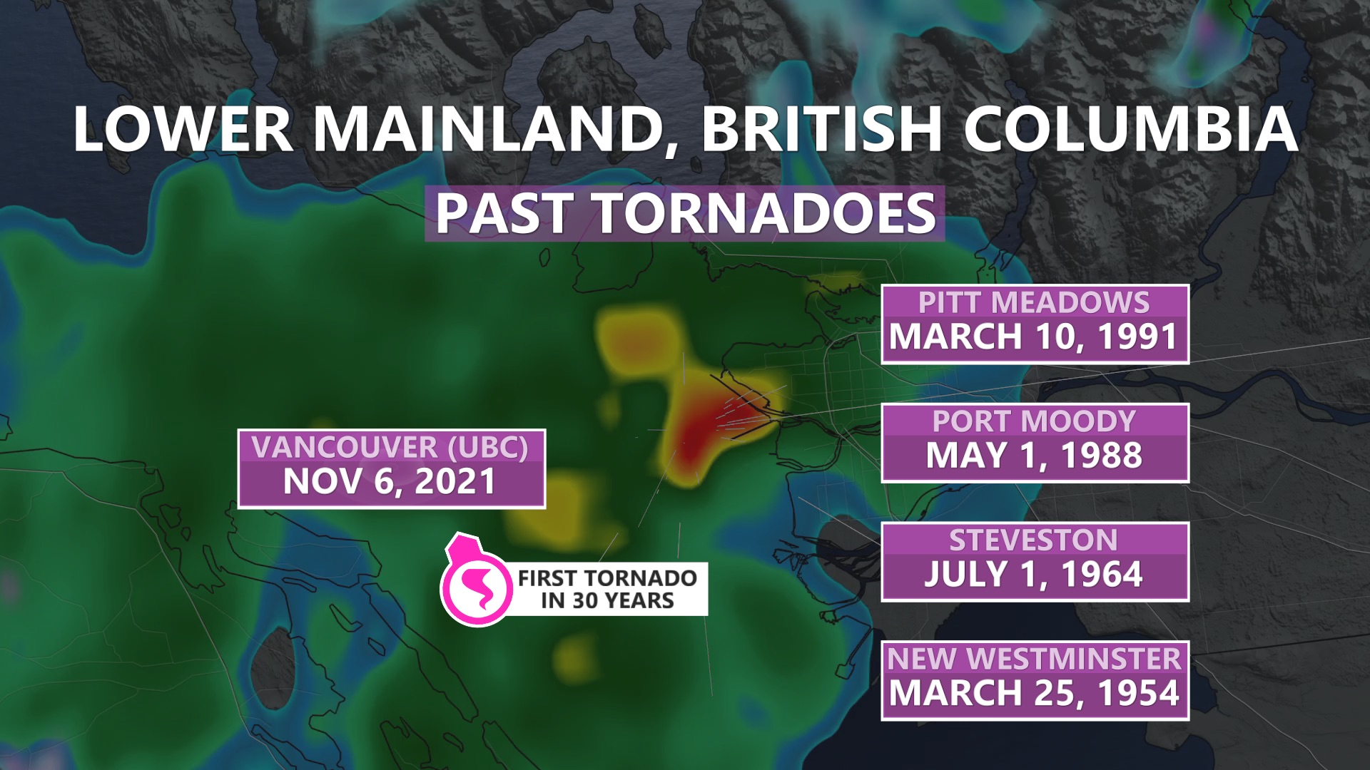
B.C. is not a hot spot for tornadoes at any time of the year, so for one to occur there in the heart of fall is certainly a rare occurrence.
Witnesses in Vancouver, B.C., captured video and photos of a tornado over the Strait of Georgia Saturday that reportedly came ashore and caused minor tree damage at the University of British Columbia (UBC) and immediate vicinity. No injuries have been reported.
SEE ALSO: Nearly 600 lives claimed by B.C.'s historic, record-breaking heat wave
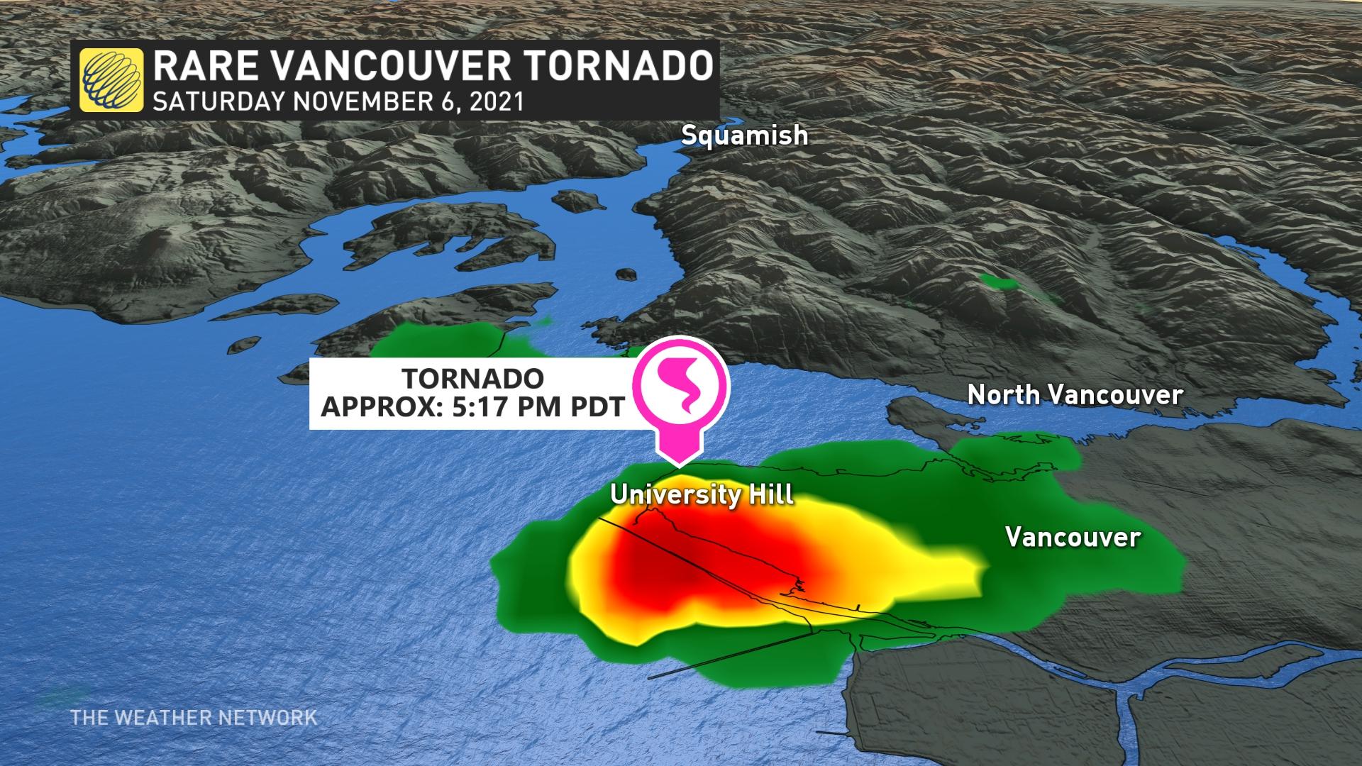
At the time on Saturday evening, Environment and Climate Change Canada (ECCC) stated a waterspout was spotted west of Vancouver International Airport, and was moving north toward western Vancouver and the mouth of Howe Sound including Bowen Island, prompting tornado watches for Howe Sound and the North Shore.
The watches were soon dropped, and power outages and damage were reported at and surrounding the UBC campus, though it's not clear if the electricity cuts were related. The tornado is under investigation.
The Western University-based Northern Tornadoes Project (NTP) sent out a tweet early Sunday morning calling it a "ultra-rare" November supercell tornado.
According to NTP, the City of Vancouver has only seen three tornadoes in recorded history (F1 in 1956, F0 in 1962, F0 in 1976), with twisters also occurring in nearby communities New Westminster (F1 in 1954), Steveston (F1 in 1964), Port Moody (F0 in 1988) and Pitt Meadows (F0 in 1991).
It didn't take long for the visuals to make it onto social media, and below is a selection of what has been circulating.
GO HERE The Weather Network - 'Ultra-rare' November tornado hits Vancouver, B.C., damage reported
Cleanup underway after possible Vancouver tornado; more strong winds forecast
By Simon Little Global News
Posted November 7, 2021 
Video offers an up-close look at strong winds associated with a large waterspout that spotted on the edge of Metro Vancouver on Saturday. The unusual meteorological phenomenon prompted Environment Canada to briefly issue a tornado watch.
Cleanup efforts are underway after rare funnel cloud occurred near the University of British Columbia, and meteorologists are warning that another powerful storm is on the way.
A massive waterspout was spotted near Vancouver International Airport around 5:30 p.m. Saturday, and moved north in the Strait of Georgia to the edge of UBC before dissipating. The incident prompted Environment Canada to issue a rare tornado watch for the region.
On Sunday, Environment Canada said further investigation was required to determine whether a tornado occurred at the time of landfall, and to assess its strength.
“I can confirm it was basically we had a cold, unstable flow and in that was embedded some fairly convective cells and this one formed into a supercell, which spawned a tornadic water spout — and that means it’s basically a tornado that formed over the water,” Environment Canada Meteorologist Mike Gismondi said.


“We’re not sure at this point whether or not at the time it moved on land, whether it was a tornado — we’re sending a couple of people out to take some photos and try and do an assessment of the damage to to confirm whether or not there was a tornado when it moved on to the land.”
Gismondi described the incident as “extremely rare,” noting that smaller waterspouts are common over the Strait of Georgia, but nothing this strong or long-lasting.
READ MORE: Large funnel cloud near Vancouver prompts brief tornado watch for Howe Sound, North Shore
Strong winds from the system uprooted trees and sent branches flying in the UBC area Saturday evening, even damaging some vehicles.
Dozens of residents of the University Endowment Lands woke up Sunday morning to discover they were still without power.
TransLink said University Boulevard, one of the key routes to UBC, was closed to all traffic and that the number 004, 014 and 099 buses were all being diverted through West 16th Avenue and Chancellor Boulevard.
“Our crews are working hard to restore service as they wait for the City of Vancouver to clear the large number of fallen trees,” TransLink said in a media release.
“We have been advised, this could take several days, until regular access is opened to traffic on this route.”

Gismondi said it could be several days to a week before Environment Canada will be able to say more about the incident with certainty, and that data will be assessed by tornado experts in the prairies.
However, he said if the event is confirmed to be a tornado, it would likely be of “F0” strength, the weakest category.
He added that while it is difficult to attribute any individual extreme weather event to climate change, the recent string of incidents was noteworthy.
“This year, we’ve seen the heat dome and now this. And then we also had the deepest low (pressure system) off the Northwest Pacific ever recorded,” he said.
“You know, all in the same year certainly seems to be trending towards a pattern.”
More strong winds in forecast
While another waterspout appears unlikely, Environment Canada issued special weather statements for most of the South and Central Coast warning of strong winds on Monday.
The alerts stretch from Metro Vancouver to Haida Gwaii, with the exception of central Vancouver Island. Environment Canada is warning of strong southeast winds of up to 110 km/h, except for the inner South Coast waters, where they are forecast to be up to 80 km/h.
READ MORE: Record-breaking ‘bomb cyclone’ weakens as it hits B.C.: Here’s what you need to know
“A rapidly deepening weather system will generate strong southeast winds over the west coast of Vancouver Island, Central Coast and Haida Gwaii beginning Monday evening,” Environment Canada said.
“The southeast winds will quickly progress into the inner south coast waters. The weather system will remain very intense Tuesday and these blustery conditions are expected to continue.”
Environment Canada said the exact track and strength of the storm systems remains uncertain, and urged people to monitor local media for updates.
© 2021 Global News, a division of Corus Entertainment Inc.
No comments:
Post a Comment