LOOK: 55 YEARS AGO, NASA TOOK ‘THE PICTURE OF THE CENTURY’
Lunar Orbiter 2 showed us the Moon in a whole new light.
JON KELVEY
11.6.2021 3:00 AM
MORE THAN A HALF-CENTURY AGO, NASA led a revolution in lunar science. In the 1960s, the space agency launched five orbital expeditions to map the surface of the Moon and scout out potential landing sites for a crewed mission. Dubbed the Lunar Orbiters 1 through 5, these missions were the key to the United States beating the Soviet Union to land a human on the Moon. Along the way, the Lunar Orbiters changed how we look at our nearest cosmic neighbor — and especially Lunar Orbiter 2.
Technically, all five of the Lunar Orbiter missions did their job — they mapped the Moon and made human trips possible. But Lunar Orbiter 1 had a rocky start.
“[NASA] figured that they needed three successful missions to actually fulfill the primary mission, which was studying various candidate landing sites for the Apollo missions,” Matt Shindell, curator at the National Air and Space Museum, tells Inverse.
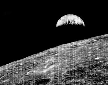
Lunar Orbiter 1, launched in August 1966, was a mixed bag. It successfully entered orbit around the Moon, the first American spacecraft to do so (the Soviets got there first in April that year with Luna 10), and took the first image of the Earth from the perspective of the Moon.
But Lunar Orbiter 1’s high-resolution camera failed, so the images are pretty low-res. These blurry images lacked the kind of detail necessary to scout Apollo Landing sites — NASA had to try again with Lunar Orbiter 2.

The first image of Earth, taken from orbit around the Moon by Lunar Orbiter 1. NASA
“Lunar Orbiter 2, on the other hand, was a perfect success,” Shindell says. Launched from Cape Canaveral on November 6, 1966, Lunar Orbiter 2 flew to the Moon and stayed active until October 1967, snapping photos that “made headlines for just how impressive and clear they were,” Shindell adds.
For that, Lunar Orbiter 2 claims the accolade of being the first entirely successful Lunar Orbiter mission, paving the way for Neil Armstrong’s boot print on the Moon.
NAILING THE PICTURE — The Lunar Orbiter spacecraft were technically identical to one another, and all shared a unique imaging system different from any of NASA’s other planetary science spacecraft.
For example, NASA’s Ranger missions to the Moon — also in the 1960s — used television cameras, while later spacecraft would use digital imaging systems. In comparison, the Lunar Orbiters used an intricate mechanical system to shoot on 70mm Kodak aerial film, develop the film themselves, and then scan and transmit the resulting images back to Earth. Each probe was also equipped with an 80mm wide-angle lens and 610mm high-resolution lens, the latter designed to take detailed photos of the lunar surface.
On Lunar Orbiter 1, the high-resolution camera malfunctioned, and the images turned out to be a fuzzy mess. But the craft did manage to snap a breathtaking wide-angle shot of the Earth and Moon. It was a captivating and thought-provoking image, but only half of the probe’s intended mission.
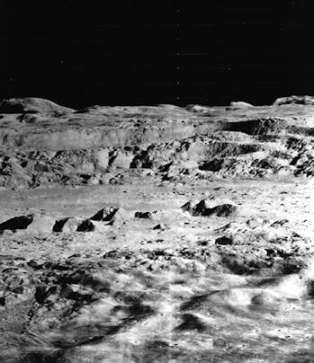
Both of Lunar Orbiter 2’s lenses functioned beautifully, snapping stunning, never-before-seen details of the lunar surface, including an image of the Copernicus Crater.

The image of Copernicus Crater on the Moon hailed as “The Picture of the Century” by LIFE Magazine. NASA
“It was called ‘The Picture of the Century,’ by Life Magazine,” Shindell says. This image and others from the mission have since been eclipsed by the many subsequent majestic, full-color photos we hungrily devour every time NASA releases them for general consumption.
Yet, Shindell says, “for its time, these Lunar Orbiter 2 images were incredibly impressive and people took note of them.”
PICTURES WITH PURPOSE — The crisp and clear pictures didn’t just make headlines. NASA used these images to understand what they might be dealing with if and when they put boots on the regolith, as it were.
Essentially, the Lunar Orbiters were just one part of a massive reconnaissance project that included four successful Ranger missions, hard landers that crashed into the Moon and took pictures all the way down, and five successful soft-landing Surveyor landers.
At the time, a team led by Egyptian-American geologist Farouk El-Baz studied the images from the Lunar Orbiter missions, applying the same principles used to study aerial photography to understand geology on Earth. From the photographs, they gleaned vital clues about the realities of the lunar surface, “based on the angle at which the shadows were falling, and other types of physical evidence in the image that revealed different geologic information,” Shindell says.

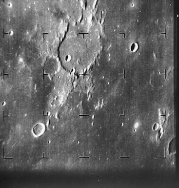
An image of the Moon’s Guericke Crater, taken by Ranger 7.NASA
There was a critical difference in El-Baz’s work on Earth: On our planet, geologists can visit the place by air to “ground truth” their image analysis. El-Baz and his team had to rely on second-hand information coming from the Ranger and Surveyor landings for the Moon.
Shindell says they still learned a great deal, but he points out that NASA ultimately decided to play it safe in case the assumptions about the lunar surface turned out to be wrong when it came to the Apollo crewed missions.
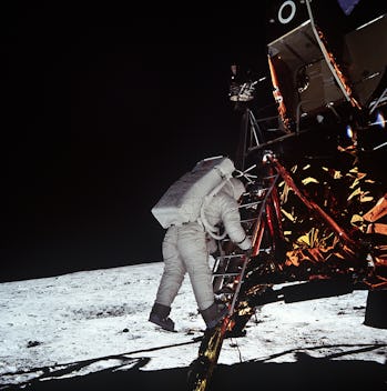
“If you look at the lunar module when sitting on the surface of the Moon, on the Apollo 11 landing, the ladder is actually pretty high up,” Shindell says.
Astronauts Neil Armstrong and Buzz Aldrin had to hop down from the lander to the Moon’s surface, and “that was partly because they have built-in this extra kind of margin for, ‘what if the lunar module sinks a little bit into the regolith?’”

Buzz Aldrin dangling above the lunar surface.NASA
The caution would prove unnecessary since the lunar surface — as El-Baz, the geologists, and the Lunar Orbiters, Rangers and Surveyors predicted — was relatively stable and capable of supporting humans and machines.
A FORGOTTEN LEGACY — Lunar Orbiter 2 sent more than 200 images of the Moon and space to Earth. The pictures show almost 1.6 million square miles of the lunar surface, including the site of Ranger 8’s crash-landing, which occurred in 1965. This location, not coincidentally, is just 15 miles away from where Apollo 11 eventually landed in the Sea of Tranquility.
These images have slipped from public memory, obscured by time and other stunning images like those taken by Neil Armstrong’s Hasselblad camera on the lunar surface itself. Yet 55 years later, the Lunar Orbiter missions should be celebrated for capturing — for the first time — the entire near-side of the Moon and 95 percent of the far side in detailed aerial photographs. These photographs are still used — and improved — by researchers today as they study Earth’s natural satellite.
“There’s been an effort at NASA Ames to reprocess a lot of the images that came back from the Lunar Orbiter program,” Shindell says. To do this, scientists are using new digital processing techniques invented long after the Lunar Orbiter went up to space.
“We now know there was even greater detail in those images than we were able to at first see.” Truly a cosmic gift that keeps giving.
11.6.2021 3:00 AM
MORE THAN A HALF-CENTURY AGO, NASA led a revolution in lunar science. In the 1960s, the space agency launched five orbital expeditions to map the surface of the Moon and scout out potential landing sites for a crewed mission. Dubbed the Lunar Orbiters 1 through 5, these missions were the key to the United States beating the Soviet Union to land a human on the Moon. Along the way, the Lunar Orbiters changed how we look at our nearest cosmic neighbor — and especially Lunar Orbiter 2.
Technically, all five of the Lunar Orbiter missions did their job — they mapped the Moon and made human trips possible. But Lunar Orbiter 1 had a rocky start.
“[NASA] figured that they needed three successful missions to actually fulfill the primary mission, which was studying various candidate landing sites for the Apollo missions,” Matt Shindell, curator at the National Air and Space Museum, tells Inverse.
Lunar Orbiter 1, launched in August 1966, was a mixed bag. It successfully entered orbit around the Moon, the first American spacecraft to do so (the Soviets got there first in April that year with Luna 10), and took the first image of the Earth from the perspective of the Moon.
But Lunar Orbiter 1’s high-resolution camera failed, so the images are pretty low-res. These blurry images lacked the kind of detail necessary to scout Apollo Landing sites — NASA had to try again with Lunar Orbiter 2.

The first image of Earth, taken from orbit around the Moon by Lunar Orbiter 1. NASA
“Lunar Orbiter 2, on the other hand, was a perfect success,” Shindell says. Launched from Cape Canaveral on November 6, 1966, Lunar Orbiter 2 flew to the Moon and stayed active until October 1967, snapping photos that “made headlines for just how impressive and clear they were,” Shindell adds.
For that, Lunar Orbiter 2 claims the accolade of being the first entirely successful Lunar Orbiter mission, paving the way for Neil Armstrong’s boot print on the Moon.
NAILING THE PICTURE — The Lunar Orbiter spacecraft were technically identical to one another, and all shared a unique imaging system different from any of NASA’s other planetary science spacecraft.
For example, NASA’s Ranger missions to the Moon — also in the 1960s — used television cameras, while later spacecraft would use digital imaging systems. In comparison, the Lunar Orbiters used an intricate mechanical system to shoot on 70mm Kodak aerial film, develop the film themselves, and then scan and transmit the resulting images back to Earth. Each probe was also equipped with an 80mm wide-angle lens and 610mm high-resolution lens, the latter designed to take detailed photos of the lunar surface.
On Lunar Orbiter 1, the high-resolution camera malfunctioned, and the images turned out to be a fuzzy mess. But the craft did manage to snap a breathtaking wide-angle shot of the Earth and Moon. It was a captivating and thought-provoking image, but only half of the probe’s intended mission.
Both of Lunar Orbiter 2’s lenses functioned beautifully, snapping stunning, never-before-seen details of the lunar surface, including an image of the Copernicus Crater.

The image of Copernicus Crater on the Moon hailed as “The Picture of the Century” by LIFE Magazine. NASA
“It was called ‘The Picture of the Century,’ by Life Magazine,” Shindell says. This image and others from the mission have since been eclipsed by the many subsequent majestic, full-color photos we hungrily devour every time NASA releases them for general consumption.
Yet, Shindell says, “for its time, these Lunar Orbiter 2 images were incredibly impressive and people took note of them.”
PICTURES WITH PURPOSE — The crisp and clear pictures didn’t just make headlines. NASA used these images to understand what they might be dealing with if and when they put boots on the regolith, as it were.
Essentially, the Lunar Orbiters were just one part of a massive reconnaissance project that included four successful Ranger missions, hard landers that crashed into the Moon and took pictures all the way down, and five successful soft-landing Surveyor landers.
At the time, a team led by Egyptian-American geologist Farouk El-Baz studied the images from the Lunar Orbiter missions, applying the same principles used to study aerial photography to understand geology on Earth. From the photographs, they gleaned vital clues about the realities of the lunar surface, “based on the angle at which the shadows were falling, and other types of physical evidence in the image that revealed different geologic information,” Shindell says.

An image of the Moon’s Guericke Crater, taken by Ranger 7.NASA
There was a critical difference in El-Baz’s work on Earth: On our planet, geologists can visit the place by air to “ground truth” their image analysis. El-Baz and his team had to rely on second-hand information coming from the Ranger and Surveyor landings for the Moon.
Shindell says they still learned a great deal, but he points out that NASA ultimately decided to play it safe in case the assumptions about the lunar surface turned out to be wrong when it came to the Apollo crewed missions.
“If you look at the lunar module when sitting on the surface of the Moon, on the Apollo 11 landing, the ladder is actually pretty high up,” Shindell says.
Astronauts Neil Armstrong and Buzz Aldrin had to hop down from the lander to the Moon’s surface, and “that was partly because they have built-in this extra kind of margin for, ‘what if the lunar module sinks a little bit into the regolith?’”

Buzz Aldrin dangling above the lunar surface.NASA
The caution would prove unnecessary since the lunar surface — as El-Baz, the geologists, and the Lunar Orbiters, Rangers and Surveyors predicted — was relatively stable and capable of supporting humans and machines.
A FORGOTTEN LEGACY — Lunar Orbiter 2 sent more than 200 images of the Moon and space to Earth. The pictures show almost 1.6 million square miles of the lunar surface, including the site of Ranger 8’s crash-landing, which occurred in 1965. This location, not coincidentally, is just 15 miles away from where Apollo 11 eventually landed in the Sea of Tranquility.
These images have slipped from public memory, obscured by time and other stunning images like those taken by Neil Armstrong’s Hasselblad camera on the lunar surface itself. Yet 55 years later, the Lunar Orbiter missions should be celebrated for capturing — for the first time — the entire near-side of the Moon and 95 percent of the far side in detailed aerial photographs. These photographs are still used — and improved — by researchers today as they study Earth’s natural satellite.
“There’s been an effort at NASA Ames to reprocess a lot of the images that came back from the Lunar Orbiter program,” Shindell says. To do this, scientists are using new digital processing techniques invented long after the Lunar Orbiter went up to space.
“We now know there was even greater detail in those images than we were able to at first see.” Truly a cosmic gift that keeps giving.
No comments:
Post a Comment