Britain’s New Polar Research Vessel Docks in Antarctica for First Time

Britain’s new polar research vessel, the RRS Sir David Attenborough, docked in Antarctica on December 17 a week after reaching the region on its maiden voyage. The much-maligned vessel, which received numerous reports in the British media due to cost overruns and construction delays, departed the U.K. in mid-November and will be conducting its research and resupply mission not returned home till June 2022.
The vessel, which gained international attention when the British voted to name it Boaty McBoatface, was handed over to the Natural Environment Research Council (NERC) late in 2020. She spent the last year undergoing additional outfitting and training for its crew as well as correcting some technical issues that appeared during the tests. After departing Harwick, England on November 16 and a brief stop in Portsmouth, she completed a three-and-a-half week transit to the Falkland Islands before officially entering Antarctica on December 13.
“The ship is a state-of-the-art research and logistics vessel, enabled by world-class infrastructure, that has been delivered by an amazing team of professional and technical experts from BAS and our industry partners,” says Jon Ager, Programme Director (AIMP), for the British Antarctic Survey which is operating the vessel.
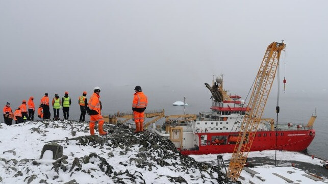
Her first call in Antarctica is at Rothera Research Station, the UK’s largest Antarctic research station on the continent. She is transporting station personnel, food, fuel, and cargo for the resupply of Britain’s research programs.

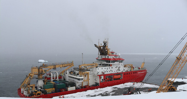
Docked at the Rothera Research Station (William Clark photo courtesy of BAS)
The RRS Sir David Attenborough’s arrival at Rothera Research Station also marks the first time the new purpose-built wharf has been used to berth the ship. The wharf which measures more than 240 feet was completed in 2020 by the Antarctic Infrastructure Modernization (AIMP). It enables Britain’s new polar research ship to berth safely and helps the station run more efficiently with a new crane to launch small science boats, a personnel gangway, and a floating pontoon to deploy scientific instruments.
The RRS Sir David Attenborough’s arrival also marks the start of the new construction season with activity on the Discovery Building for the third year in a row, a new state of the art, science, and operations facility for Rothera Research Station. Due to the harsh, cold Antarctic environment, construction can only take place during the Antarctic summer months. Over 50 members of a specialist construction team arrived last month and will work until April on erecting the main steel structure, installation of ground floor pre-cast concrete slabs, ground drainage, and site-wide services.
“Everyone on board is thrilled to arrive at Rothera for the first time,” said Will Whatley, Captain of the RRS Sir David Attenborough. “This is a really exciting and proud moment for us, and another huge milestone to have achieved. As we’ve traveled further South, we’ve had the chance to put the ship through its paces in Antarctic conditions and I’m pleased to report the ship has performed really well.”
After calling at Rothera, the RRS Sir David Attenborough will continue its mission South, making calls at Signy, King Edward Point, and Bird Island research stations, and heading to the Stange Ice Front for its ice trials.

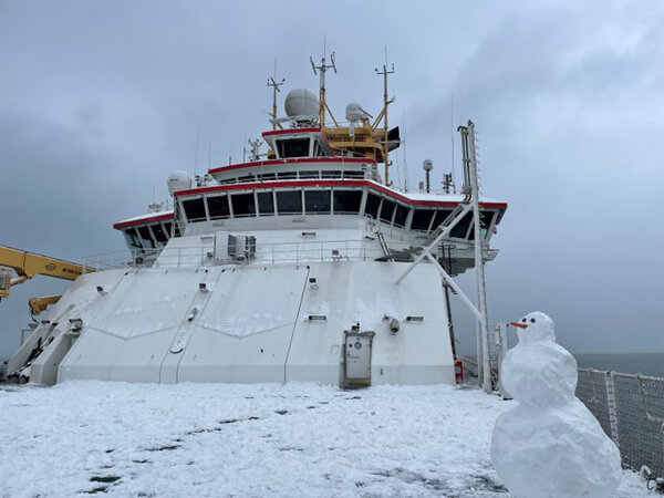
Fun moment during the three-and-a-half week trip from the UK to the Antarctic (Jenna Plank photo courtesy of BAS)
Norwegian Researchers Build a Floating "Ocean Lab"

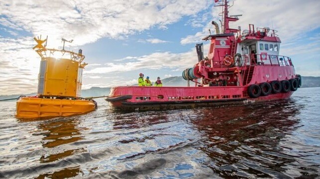
Just off the small island of Munkholmen, outside the city Trondheim, the first of two observation buoys is now installed to collect data from the fjord. With a diameter of five meters and a yellow colour, the buoy is easy to spot from land. The buoys will be powered primarily by wind and solar, and don’t need to be permanently manned.
“It is probably an understatement to call this a buoy. A floating laboratory would probably be a better description,” says SINTEF researcher Emlyn Davies.
He is a marine scientist and has helped to develop some of the equipment that will be undertaking continuous measurements of marine environmental data. The research buoy will be important for testing ocean sensor technology, the education of future marine scientists, and establishing long-term data on the status of the environment in the fjord.
The information from the buoys will be used for increasing environmental understanding and for developing and updating models. Ocean models can forecast things like current conditions and algae blooms, but more knowledge is needed in order to further develop them.
The floating laboratory will also contribute to making local environmental policy more knowledge-based.
Important part of “OceanLab”
The second buoy, which has a diameter of about two metres, will be located outside Ingdalen in the municipality of Orkland. Both buoys are part of OceanLab, which will host one of the world’s most advanced array of data collection platforms for marine research.
According to Davies, OceanLab is a new and state-of-the-art national research infrastructure that is being established in Trondheim. It is a collaborative venture between SINTEF and NTNU, funded by the Research Council of Norway. OceanLab will contribute to research on underwater robotics, aquaculture, autonomous shipping and environmental research. The observation buoys are particularly important for increasing understanding of the environment in the fjord.
The data collected will be made available in real time on a digital platform for anyone who is interested.
“As we gradually develop new ways of utilising resources in the ocean, we also have an increasing need to collect data. This is important in order to develop good ocean models that can predict the impact of developments – something which is also one of the goals of the UN Ocean Decade. This will provide us with more knowledge about the consequences of what we do. One example of this is the increasing interest in harvesting more of the smallest organisms found in the sea, such as Calanus finmarchius and krill. The data we collect will provide a better understanding of how these affect the environment,” says Davies.
Collecting large amounts of marine research data
The buoy off Munkholmen will collect data on everything that happens close to it, such as the weather, waves, current and temperature, and it is specially equipped to monitor underwater life.
It will have a range of features, including particle imaging, acoustic communication and a plug-and-play interface for customised sensors. In practice, this means that researchers can add and remove sensors as required. The floating lab will also have equipment that can take photos of organisms that are invisible to the human eye, such as phytoplankton.
“By looking at the kind of plankton here, what it looks like and how it changes during the course of the season, we will be able to see, for example, how the River Nid affects the ecosystem in the fjord. With climate change we are seeing more extreme weather with heavy rain that carries water from the land and out to the ocean. When sediment enters the fjord it blocks the light. One of the effects is that it prevents algae from growing, which in turn results in a reduction in the food available for organisms and lowers oxygen production. To understand these kinds of changes and their consequences, we need to collect environmental data over the longer-term,” says Davies.
One of the most advanced instruments on the buoy is called CytoSub. This equipment creates on-site images by lowering an instrument called a flow cytometer, which produces microscope images and fluorescence signatures of particles and plankton right down to nano-level.
The reason is that phytoplankton are critical organisms for ocean ecosystems. Phytoplankton produce about 50 per cent of the world’s oxygen. They also harness energy from sunlight which scientists can measure by using light sensors. The plankton is also a primary source of food that in turn is eaten by larger organisms.
No random placement
The position of the buoy at Munkholmen has been calculated by using a 3D model developed by SINTEF called SINMOD. This model system connects and simulates physical and biological processes in the ocean. According to SINMOD the selected point is representative of much of the fjord.
“Even if the data is only collected in one place, what is happening in Trondheim Fjord may be representative of ocean conditions elsewhere in the world. For example, if the sediment darkens the water and has an impact on nature, then that knowledge is transferable to other coastal areas,” says Davies. “They will serve as a platform that can support faster technology development and prototyping of new sensors, as well as comparisons of different sensors that measure the same thing in different ways. Here we can test new technology while it is being developed."
Testing this type of technology is often both costly and time-consuming, but here the researchers and tech companies will only be a few hundred meters away.
“We can get here in minutes, plug in what we want to test and obtain the data very quickly,” says Davies.
Creating power for own consumption
SINTEF Ocean has acquired the buoy from the British company Hydrosphere, which has supplied the buoy in accordance with a design developed by Mobilis in France. They have developed the buoy specifically for OceanLab.
“This is the largest buoy we have developed so far. It has four chambers for sensors and measuring equipment and it has also been adapted for power generation using solar cells, wind cells and spare fuel cells so that it is self-sufficient in electricity – even in winter, says John Caskey of Hydrosphere.
This article appears courtesy of Gemini News and may be found in its original form here.
The opinions expressed herein are the author's and not necessarily those of The Maritime Ex
No comments:
Post a Comment