Discovery of 72-kilometer fault line on Canada's Vancouver Island
A team of geologists, mineralogists and Earth and ocean scientists affiliated with institutions in Canada, the U.S. and France has discovered a 72-kilometer fault line on Canada's Vancouver Island. In their project, reported in the journal Tectonics, the group discovered the fault line after finding evidence of an earthquake on the Saanich Peninsula thousands of years ago.
Earth scientists have long suspected that parts of the Georgia Basin in Canada has a seismic history. But evidence of earthquakes has been difficult to find due to the forest cover in the region. In this new effort, the researchers conducted analysis of historical imagery, conducted remote sensing, hiked through forests and conducted shallow geophysical surveys to learn more about the possible seismic history of the Saanich Peninsula, which is situated on the southeastern part of Vancouver Island.
Part of their effort included digging trenches for clues, which led them to find minerals in rock that suggested magnetic field changes over time—an indication of rock formations that were broken or pulled apart and strong evidence of a fault line. In continuing to study such formations, they found further evidence of a fault line that ran for approximately 72 kilometers.
Additionally, study of the fault line showed it to be of the slip-dip kind, where blocks of rock move up and down against each other, rather than the side-to-side sliding that occurs in other fault lines. The research team named it the XEOLXELEK-Elk Lake Fault, and noted that it runs diagonally (northwest to southeast) along the Saanich Peninsula north of Victoria.
The researchers also note that should an earthquake occur at the site, it is likely that it would generate a tsunami because the fault line passes under the Saanich Inlet. Such a tsunami could strike places in Canada, such as Victoria and Vancouver, and places in the U.S. such as Seattle, Bellingham, Olympia and Tacoma. They also note that it is impossible to tell how soon an earthquake might strike the region, but note that evidence they gathered suggested the last one was approximately 2,300 to 4,700 years ago and that it was likely between magnitude 6.1 and 7.6.
More information: Nicolas Harrichhausen et al, Discovery of an Active Forearc Fault in an Urban Region: Holocene Rupture on the XEOLXELEK‐Elk Lake Fault, Victoria, British Columbia, Canada, Tectonics (2023). DOI: 10.1029/2023TC008170
© 2023 Science X Network
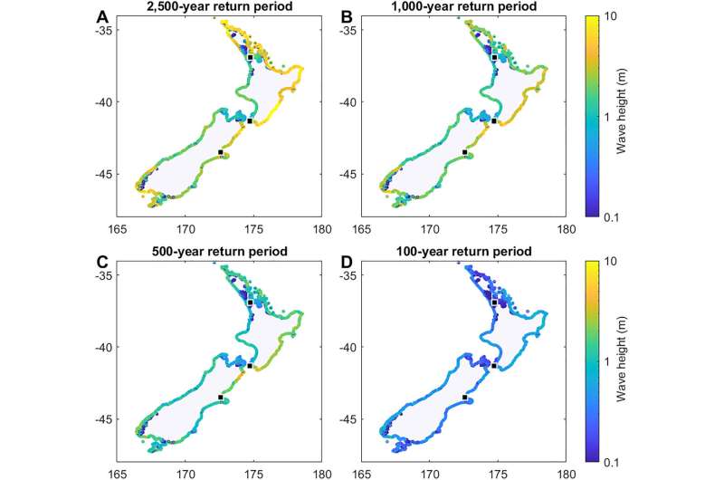
Model shows New Zealand should expect 15-meter tsunami every 580 years

A team of geographers, Earth scientists and environmental scientists affiliated with several institutions in New Zealand, working with that country's National Institute of Water and Atmospheric Research, has found that it is possible to model the number and type of tsunamis that are likely to strike a given area over a given period of time.
In their paper published in the journal Journal of Geophysical Research: Solid Earth, the group describes the model they built and the types of data they gave it to help them gain some insight into the number and types of earthquakes New Zealand is likely to experience in the coming years, along with possible tsunamis.
New Zealand is known for its periodic earthquakes—just seven years ago, the 7.8 magnitude Kaikōura quake struck parts of Marlborough and northern Canterbury. Less well known are its tsunamis. This is likely because they happen far less often. The last major tsunami to strike New Zealand was in 1868, and that was triggered by an earthquake in Chile.
Still, because New Zealand sits near two subduction zones, scientists know that one is likely to strike sometime in the future. The only questions are when and how big will it be. To make some educated guesses, the researchers involved in this new study created a model designed to show earthquakes and related tsunamis that have struck in the past and to predict when they may strike in the future.
Prior research efforts have uncovered historical records of earthquakes but they only go back approximately a century and a half. Prior geological research has also revealed evidence of older quakes and resulting tsunamis, but such studies have not been able to reveal much about the long histories of earthquakes striking New Zealand. The researchers used data from such studies to create their model and added other data, such as information about the geometry of the region, fault system physics and the physical locations of faults in the region, and the amount of friction that has been measured.
They then ran simulations covering 30,000 years of simulated history showing all the likely earthquakes that have struck the region during that time. It showed 2,585 earthquakes with magnitudes ranging from 7.0 to 9.25. The model also showed which subduction zones are likely to be the source of earthquakes causing locally generated tsunamis. They then calculated the size of tsunamis based on earthquake strength and found that the largest would likely be approximately 28 meters. The model also suggested that New Zealand is likely to experience a tsunami of at least five meters every 77 years, and one of 15 meters every 580 years.
More information: Laura Hughes et al, A Novel Method to Determine Probabilistic Tsunami Hazard Using a Physics‐Based Synthetic Earthquake Catalog: A New Zealand Case Study, Journal of Geophysical Research: Solid Earth (2023). DOI: 10.1029/2023JB027207
Journal information: Journal of Geophysical Research: Solid Eart© 2023 Science X Network

No comments:
Post a Comment