SPACE/COSMOS
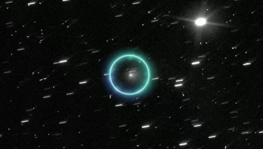
An interstellar comet that sparked speculation about extraterrestrial visitors has departed the solar system after making its closest approach to Earth at 270 million kilometres on December 19, with Russian scientists dismissing claims the object could be an alien spacecraft, RIA Novosti reported on December 24.
The object designated 3I/ATLAS was discovered on July 1, 2025, by a Chilean telescope operated by NASA's Asteroid Terrestrial-impact Last Alert System. Its high velocity, exceeding 50 kilometres per second, and unusual trajectory identified it as interstellar.
Harvard University astronomer Abi Loeb published an article suggesting the cosmic object could have technological origins with a crew inside, claiming aliens might be hostile and planning to approach Earth covertly from the direction of the Sun. "The consequences could be catastrophic for humanity," Loeb stated in his blog, provoking media sensation.
Natan Eismont, lead researcher at Russia's Space Research Institute, stated nothing surprising occurred in the comet's behaviour.
"Of course it has peculiarities, such as increased carbon dioxide content. Otherwise there are no miracles, everything within known physics. Changes in velocity can be related to gas and dust emissions, which is typical for comets," Eismont stated.
The researcher noted that controversy raised by Loeb proved beneficial by attracting public attention to science and potentially increasing funding for planetary defence programmes. Observation capabilities are growing, raising chances of detecting genuinely dangerous objects in time, Eismont stated. "I think Loeb understands perfectly well that everything he says is fiction," the researcher noted.
Loeb's article, published on a preprint site, contains an important caveat describing the work as "primarily a pedagogical exercise".
The comet's coma measures approximately 24 kilometres in diameter. Its trajectory suggested it arrived from the thick disc of the Milky Way galaxy, estimated at seven billion years old, rather than the younger thin disc containing the 4.5 bn-year-old solar system.
NASA scientists believe the object could have originated in an ancient planetary system predating our own.
3I/ATLAS became the third known visitor from another star system in eight years. The Pan-STARRS telescope detected cigar-shaped asteroid 1I/Oumuamua in 2017, whilst Crimean amateur astronomer Gennady Borisov spotted the first interstellar comet 2I/Borisov in 2019.
Eismont stated such discoveries will increase in coming years as telescope capabilities improve sharply. Interstellar objects visited the solar system previously but could not be registered, whilst visits from other galaxies are possible though far rarer.
Stardust study resets how life’s atoms spread through space
image:
Dust clouds reflect starlight around the star R Doradus. As it nears the end of its life, the star is shedding its outer layers, forming clouds of gas and dust around it (shown here in pink and yellow). Scientists have long believed that starlight illuminating these clouds could power a stellar wind. But the colour of the light around the star reflected by dust, , shows that the dust grains are too small to explain the star’s wind. The image was taken in polarised visible light with VLT/SPHERE. In the centre in yellow and orange, we see ALMA’s image showing the surface of the star.
view moreCredit: ESO/T. Schirmer/T. Khouri; ALMA (ESO/NAOJ/NRAO)
Starlight and stardust are not enough to drive the powerful winds of giant stars, transporting the building blocks of life through our galaxy. That’s the conclusion of a new study from Chalmers University of Technology, Sweden, of red giant star R Doradus. The result overturns a long-held idea about how the atoms needed for life are spread.
“We thought we had a good idea of how the process worked. It turns out we were wrong. For us as scientists, that’s the most exciting result”, says Theo Khouri, astronomer at Chalmers and joint leader of the study.
To understand the origins of life on Earth, it’s important for astronomers to understand how giant stars power their winds. For decades, scientists have believed that winds from red giant stars — which seed the galaxy with carbon, oxygen, nitrogen and other elements essential for life — are powered when starlight pushes against grains of newly formed dust. The new observations of R Doradus challenge this picture.
Red giant stars are the older, cooler cousins of the Sun. As they age, they lose large amounts of material through stellar winds, enriching the space between stars with the raw ingredients for future planets and life. Despite their importance, the physical mechanism driving these winds has remained uncertain.
Astronomers studying the nearby red giant star R Doradus have found that the tiny grains of stardust surrounding the star are too small to be pushed outward by starlight strongly enough to escape into interstellar space.
The study, led by researchers at Chalmers University of Technology, is published in the scientific journal Astronomy & Astrophysics.
“Using the world’s best telescopes, we can now make detailed observations of the closest giant stars. R Doradus is a favourite target of ours – it’s bright, nearby, and typical of the most common type of red giant”, says Theo Khouri. “
The team observed R Doradus using the Sphere instrument on ESO’s Very Large Telescope, measuring light reflected by dust grains in a region roughly the size of our Solar System. By analysing polarised light at different wavelengths, the researchers determined the size and composition of the grains, finding them consistent with common forms of stardust such as silicates and alumina.
The observations were then combined with advanced computer simulations that model how starlight interacts with dust.
“For the first time, we were able to carry out stringent tests of whether these dust grains can feel a strong enough push from the star’s light”, says Thiébaut Schirmer.
The push of starlight is not enough, the team was surprised to find. The grains surrounding R Doradus are typically only about one ten-thousandth of a millimetre across — far too small for starlight alone to drive the star’s wind into space.
“Dust is definitely present, and it is illuminated by the star,” says Thiébaut Schirmer. “But it simply doesn’t provide enough force to explain what we see.”
The findings point to other, more complex processes playing a major role. The team has previously used the ALMA telescope to capture images of enormous bubbles rising and falling on the surface of R Doradus.
“Even though the simplest explanation doesn’t work, there are exciting alternatives to explore,” says Wouter Vlemmings, professor at Chalmers and co-author of the study. “Giant convective bubbles, stellar pulsations, or dramatic episodes of dust formation could all help explain how these winds are launched.”
More about the research
The study, “An empirical view of the extended atmosphere and inner envelope of the asymptotic giant branch star R Doradus II. Constraining the dust properties with radiative transfer modelling”, is published in Astronomy & Astrophysics.
The research was carried out as part of the cross-disciplinary project “The origin and fate of dust in our Universe” funded by the Knut and Alice Wallenberg Foundation as a collaboration between researchers at Chalmers University of Technology and the University of Gothenburg.
The team consists of Thiébaut Schirmer, Theo Khouri, Wouter Vlemmings, Gunnar Nyman, Matthias Maercker, Ramlal Unnikrishnan, Behzad Bojnordi Arbab, Kirsten K. Knudsen, and Susanne Aalto. All the co-authors are based at Chalmers University of Technology, Sweden, except Gunnar Nyman, at the University of Gothenburg, Sweden.
The team used the instrument Sphere (Spectro-Polarimetric High-contrast Exoplanet REsearch) on the Very Large Telescope (VLT), located at the Paranal Observatory in Chile. The VLT is operated by ESO, the European Southern Observatory. Sweden is one of ESO’s 16 member states.
More about the star
R Doradus is a red giant star located only 180 light years from Earth in the southern hemisphere constellation of Dorado, the Swordfish. Born with a mass similar to the Sun’s, it is now nearing the end of its life. It’s an example of an AGB star (AGB = asymptotic giant branch). Such stars lose their outer layers to interstellar space in the form of dense stellar winds made of gas and dust. R Doradus loses the equivalent of a third of the Earth’s mass every decade. Other similar stars can lose mass hundreds or thousands of times faster. In the distant future, several billion years from now, the Sun is expected to become a star just like R Doradus.
Wide-field view of the region of the sky around the star R Doradus.
Credit
ESO/Digitized Sky Survey 2/Davide De Martin
The sky above ESO’s VLT (Very Large Telescope) in Chile. The star R Doradus lies just to the left of the telescope at the centre of the image, close to the Large Magellanic Cloud, here visible as a bright fuzzy patch in the sky.
Credit
P. Horálek/ESO
Journal
Astronomy and Astrophysics
Method of Research
Observational study
Subject of Research
Not applicable
Article Title
An empirical view of the extended atmosphere and inner envelope of the asymptotic giant branch star R Doradus
AI enabled launch vehicles: Next potential disruptive technology after reusability
Tsinghua University Press
The global space industry has entered a new phase, characterized by the construction of large-scale satellite constellation construction, human lunar exploration and development and others. As the prerequisite and foundation of all space activities, space transportation systems are experiencing rapid growth in the scale of access to space. Especially with the increasing commercialization, it is expected that within the next 20 years, the scale of access to space will exceed several hundred thousand tons, with annual launch numbers reaching tens of thousands, and this number will continue to rise. Space transportation systems face the challenge of low-cost, high-frequency, and highly reliable airline-flight-mode development.
The rapidly developing reusable technology can effectively solve the current issue of high launch costs. However, high-frequency launches and highly reliable flights still remain significant challenges. In recent years, artificial intelligence (AI) technology has rapidly developed and has become important across various industries. Enabled space transportation with AI technology holds great promise in addressing the challenges of high-frequency launches and highly reliable flights in the era of large-scale access to space. It is expected to become the next disruptive technology in the field of space transportation, following reusability.
AI can be enabled in four scenarios to achieve agile testing and launch preparation, significantly improve flight reliability, achieve rapid maintenance and efficient safety operation & control.
Based on AI methods, the authors’ goal is to build an intelligent space transportation system that includes smart test launches, high-reliability flight, agile maintenance assessment, and efficient operation control, aiming to achieve test, inspection, and decision-making times for large launch vehicles at the hour level. By integrating return-to-launch-site (RTLS) technology, the system will enable hour-level re-launches after recovery. The autonomous fault location time for test launches will reach the minute level, and the flight reliability will improve by 1-2 orders of magnitude even in case of non-fatal faults. Meanwhile reliable and agile health assessment and maintenance strategies are established to support the optimization of reusable lifespan of launch vehicles. Besides, the integrated space-earth situational awareness, flight operation management scheduling, and coordinated control are realized to support the reliable and safe operation management and control of the entire space-earth system.
Original Source
Haipeng Chen, Xiaowei Wang, Feng Zhang. AI Enabled Launch Vehicle: Next Potential Disruptive Technology After Reusability [J]. Chinese Journal of Aeronautics, 2025, 38(10): 103756, https://doi.org/10.1016/j.cja.2025.103756.
About Chinese Journal of Aeronautics
Chinese Journal of Aeronautics (CJA) is an open access, peer-reviewed international journal covering all aspects of aerospace engineering, monthly published by Elsevier. The Journal reports the scientific and technological achievements and frontiers in aeronautic engineering and astronautic engineering, in both theory and practice. CJA is indexed in SCI (IF = 5.7, Q1), EI, IAA, AJ, CSA, Scopus.
Journal
Chinese Journal of Aeronautics
Article Title
AI Enabled Launch Vehicle: Next Potential Disruptive Technology After Reusability
ACA-SIM: A robust way to decode satellite signals over complex waters
image:
The spatial distribution of field-measured data used in this study.
view moreCredit: Journal of Remote Sensing
A new study introduces ACA-SIM (atmospheric correction based on satellite–in situ matchup data), a neural-network-based atmospheric correction algorithm that uses real satellite–Aerosol Robotic Network-Ocean Color (AERONET-OC) matchups to improve the accuracy of atmospheric correction over coastal waters. By learning from real-world satellite radiance and in-situ reflectance data, ACA-SIM significantly reduces errors and striping artifacts in ocean color products, outperforming existing models in turbid water and complex-aerosol conditions such as the Bohai Sea, North Africa dust zones, and Australian bushfire regions.
Coastal waters are among the most dynamic and complex environments on Earth, where suspended sediments, dissolved organic matter, and aerosols make satellite observation extremely challenging. Traditional atmospheric correction methods often rely on simplified assumptions that fail in turbid or dusty regions, resulting in inaccurate retrievals of ocean color and water quality parameters. The difficulty is further amplified by sensor noise and striping artifacts. Due to these challenges, it is essential to develop a robust atmospheric correction approach that can adapt to real-world conditions in coastal environments, improving the reliability of global ocean color observations.
Researchers from Xiamen University published (DOI: 10.34133/remotesensing.0886) their findings in the Journal of Remote Sensing on October 16, 2025. Their paper presents ACA-SIM (atmospheric correction based on satellite–in situ matchup data)—an atmospheric correction algorithm based on satellite–Aerosol Robotic Network-Ocean Color (AERONET-OC) matchup data—which uses neural networks trained on real satellite and field measurements. The method addresses the persistent problem of retrieving accurate remote-sensing reflectance (Rrs) from coastal waters affected by aerosols, dust, and smoke, offering a promising alternative to existing NASA approaches.
The ACA-SIM algorithm employs a multilayer neural network trained on more than 8,800 satellite–AERONET-OC matchups spanning diverse water and aerosol types worldwide. Unlike previous models that relied on simulated data, ACA-SIM directly incorporates real-world sensor effects—such as striping and stray light—into its learning process. When tested against independent field data, ACA-SIM achieved an average mean absolute percentage difference (MAPD) of ~15% in blue spectral bands, compared with ~32% for OC-SMART and >50% for NASA's standard algorithm. It maintained stable performance even under high solar angles, strong glint, or absorbing aerosol conditions, demonstrating its resilience and general applicability to various coastal environments.
To construct the training dataset, the team combined satellite top-of-atmosphere reflectance (ρt) from MODIS-Aqua with in-situ Rrs from more than 40 AERONET-OC stations worldwide. These matchups captured a wide range of observation geometries, turbidity levels, and aerosol types—from marine and continental aerosols to strongly absorbing dust and smoke. A four-layer multilayer perceptron (512–256–128–64 neurons) was optimized to predict Rrs at 12 MODIS wavelengths between 412 and 869 nm. Validation against AERONET-OC and ship-based datasets confirmed that ACA-SIM consistently outperforms NASA and OC-SMART methods in both accuracy and robustness. When applied to MODIS-Aqua imagery over the Bohai and Yellow Seas, West Africa dust regions, and Australian bushfire zones, ACA-SIM eliminated negative Rrs values, minimized striping artifacts, and preserved realistic water-mass patterns—delivering clean, physically consistent ocean color maps even in challenging atmospheric conditions.
“Our goal was to let the algorithm learn from reality rather than simulation,” said Prof. Zhongping Lee, corresponding author of the study. “By training ACA-SIM on genuine satellite–field matchups, we allowed it to capture subtle sensor behaviors and atmospheric effects that synthetic datasets cannot reproduce. The outcome is a smarter, more reliable correction system that ensures accurate monitoring of coastal ecosystems under even highly complex atmospheric scenarios.”
The team compiled global AERONET-OC data (2002–2024) and matched them with MODIS-Aqua satellite radiance within a ±1-hour window to ensure temporal consistency. A rigorous data-quality screening excluded contaminated pixels while preserving moderately glinted or hazy cases to enhance model generalization. The neural network was trained using 80% of the matchups and validated on the remaining 20%, with early-stopping criteria to prevent overfitting. Statistical metrics—including coefficient of determination (R²), MAPD, and bias—were used to benchmark ACA-SIM against NASA Standard and OC-SMART algorithms.
The success of ACA-SIM highlights the power of data-driven approaches in Earth observation. The researchers plan to extend this framework to other satellite sensors such as VIIRS and Sentinel-3, aiming for a unified, cross-platform atmospheric correction model. By generating consistent and accurate ocean color products, ACA-SIM could transform long-term coastal monitoring, improve assessments of algal blooms, sediment transport, and carbon fluxes, and ultimately support sustainable management of marine environments in an era of accelerating climate change.
###
References
DOI
Original Source URL
https://doi.org/10.34133/remotesensing.0886
Funding information
We are grateful for the financial support from the National Key Research and Development Program of China (2022YFC3104901), the National Natural Science Foundation of China (#42430107), Fujian Ocean Innovation Laboratory, Fujian Satellite Data Development, Co., Ltd., and Fujian Haisi Digital Technology Co., Ltd.
About Journal of Remote Sensing
The Journal of Remote Sensing, an online-only Open Access journal published in association with AIR-CAS, promotes the theory, science, and technology of remote sensing, as well as interdisciplinary research within earth and information science.
Journal
Journal of Remote Sensing
Subject of Research
Not applicable
Article Title
Atmospheric Correction of Coastal Waters Based on Satellite–AERONET-OC Matchups
When satellites fall short: How 5G and GNSS team up for reliable urban positioning
Aerospace Information Research Institute, Chinese Academy of Sciences
image:
Deeply integrated fusion of commercial 5G NR multi-beam signals and GNSS.
view moreCredit: Satellite Navigation
Finding accurate locations in dense cities has long challenged satellite-based navigation, where tall buildings and signal blockage often lead to large errors or complete service loss. A new study presents a deeply integrated positioning approach that combines commercial 5G New Radio (NR) signals with Global Navigation Satellite Systems (GNSS) to overcome these limitations. By strengthening 5G signal tracking and deeply fusing it with satellite measurements, the method significantly improves both ranging stability and positioning accuracy. Real-world tests show that the system maintains reliable performance even in heavily obstructed environments and when only a few satellites are available, offering a promising solution for robust urban navigation.
GNSS technologies underpin modern navigation, from smartphones to autonomous vehicles, but their reliability drops sharply in urban canyons, shaded streets, and complex outdoor environments. Traditional solutions often rely on inertial sensors or vision-based systems, which add cost, computational burden, or sensitivity to environmental conditions. Meanwhile, commercial 5G networks are rapidly expanding worldwide, providing dense infrastructure and wide bandwidth that are attractive for positioning. However, practical challenges—including multipath interference, clock bias, and complex multi-beam transmissions—have limited their real-world use for navigation. Based on these challenges, there is a clear need for an integrated approach that can fully exploit 5G signals while compensating for the weaknesses of satellite navigation.
In a study published (DOI: 10.1186/s43020-025-00183-8) in Satellite Navigation in 2025, researchers from Wuhan University, The Chinese University of Hong Kong (Shenzhen), and Shandong University of Science and Technology report a new positioning framework that tightly integrates commercial 5G NR signals with GNSS. The approach is designed to improve navigation reliability in urban environments where satellite signals are frequently degraded. By combining advanced 5G signal tracking with real-time fusion of satellite and cellular measurements, the system delivers more accurate and stable positioning under real-world conditions.
The research introduces a deep fusion strategy that enhances both signal tracking and positioning estimation. At the signal level, the team developed a method that jointly uses 5G synchronization and reference signals to stabilize tracking in environments affected by multipath interference. This design substantially reduces ranging errors compared with conventional 5G-only approaches. To further improve performance under weak signal conditions, a phase-stabilized Kalman filter was incorporated into the tracking loop, helping maintain accurate carrier phase estimates even when signal quality drops.
Beyond signal processing, the study applies an extended Kalman filter to deeply fuse 5G and GNSS measurements. Unlike loosely and tightly coupled methods, the fused position and clock estimates are fed back to correct the 5G tracking process in real time. Field experiments conducted in complex outdoor environments show that this deep integration significantly improves positioning accuracy in both horizontal and vertical directions. Importantly, the system continues to deliver reliable positioning when satellite visibility is severely limited—conditions under which conventional GNSS solutions often fail. These results demonstrate the practical value of combining 5G and satellite navigation in real urban settings.
“This work shows that commercial 5G signals can do much more than support communication,” an author of the study said. “By deeply integrating 5G with GNSS and addressing real-world challenges such as multipath and clock errors, we demonstrate a practical pathway toward reliable urban positioning. The key advantage is robustness—our system continues to work when satellite-only solutions struggle. This opens new possibilities for navigation in cities, where reliable positioning is often the hardest to achieve.”
The findings point to a wide range of applications in urban navigation and location-based services. Autonomous vehicles, delivery robots, smart transportation systems, and connected infrastructure could all benefit from more reliable positioning in challenging environments. Because the method leverages existing commercial 5G networks, it can be deployed without major changes to current infrastructure. As cities become more connected and navigation demands increase, deeply integrated 5G–GNSS solutions like this one may play a key role in enabling safe, accurate, and continuous positioning for next-generation intelligent systems.
###
References
DOI
Original Source URL
https://doi.org/10.1186/s43020-025-00183-8
Funding information
The National Natural Science Foundation of China (42171417);
Medium- and Long-term Scientific and Technological Planning Projects for Radio, Television and Audio-Visual Networks;
Guangxi Science and Technology Major Project (AA22068072);
Major Science and Technology Project of Jiangsu Province (No.BG2024003).
About Satellite Navigation
Satellite Navigation (E-ISSN: 2662-1363; ISSN: 2662-9291) is the official journal of Aerospace Information Research Institute, Chinese Academy of Sciences. The journal aims to report innovative ideas, new results or progress on the theoretical techniques and applications of satellite navigation. The journal welcomes original articles, reviews and commentaries.
Journal
Satellite Navigation
Subject of Research
Not applicable
Article Title
5G NR robust tracking and positioning with GNSS assistance
Article Publication Date
8-Dec-2025
No comments:
Post a Comment