Canadian Hurricane Centre Watching Possible Track of Hurricane Sam

(Photo via Canadian Hurricane Centre Twitter.)
Newfoundland and Labrador could find itself in the crosshairs of yet another hurricane next week, but forecasters are warning that it is still far too early to make any determinations about the storm’s path.
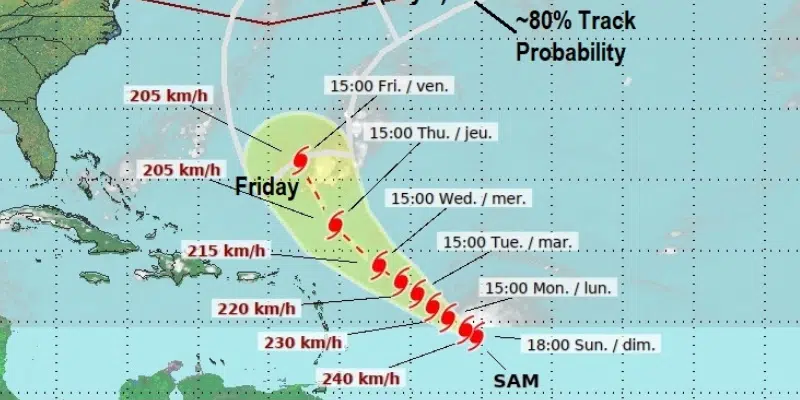
With the damage caused by Hurricane Larry still fresh in mind, social media was abuzz over the weekend after the Canadian Hurricane Centre posted a graphic showing this province in the possible track for Hurricane Sam.
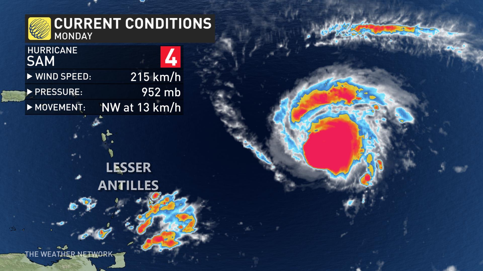
Sam is currently a category four storm in the southern part of the Atlantic Ocean.
Though Newfoundland is in the potential track, the Canadian Hurricane Centre notes that there is a “very broad range” in terms of possible tracks at this time, which show that the storm could hit the island or stay well out in the Atlantic.
Environment Canada meteorologist Mike Vandenberg says there’s still “significant uncertainty” in the hurricane’s guidance.
He says it’s not outside the realm of possibility for Sam to hit us, but it is still far too early to tell.
In the storm’s immediate future, Vandenberg says the storm will arc towards Bermuda as the week progresses.
Sam holds onto major hurricane status, eyeing potential Canadian impact
Hurricane Sam continues to rage over the open Atlantic waters as a major hurricane, with the Canadian Hurricane Centre now keeping a close eye on its track and potential impacts on the East Coast over the next week.

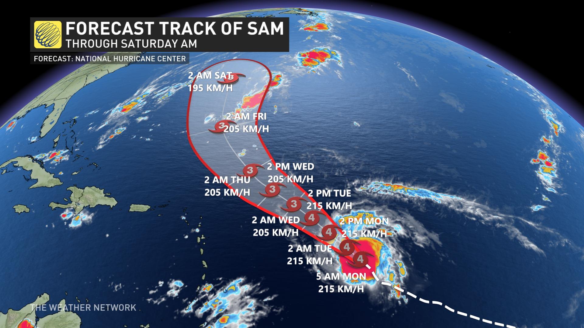
As of the Monday morning update, the U.S. National Hurricane Center (NHC) said the hurricane was about 1,290 km east-southeast of the northern Leeward Islands and moving toward the northwest near 13 km/h.
"This general motion is expected to continue for the next several days, with an increase in forward speed beginning on Thursday," the NHC says.
On Saturday, Sam became a major hurricane when it crossed the Category 3 threshold, then reached Category 4 later that day. Sam remains a Category 4 hurricane with maximum sustained winds near 215 km/h and even higher gusts. Little change in strength is expected during the next day or so and Sam is expected to remain as a major hurricane for several days.

At this point, it looks like Bermuda will be spared from hurricane conditions as Sam is expected to track well to the east of the island. However, heavy rain and tropical storm force winds are still expected across Bermuda on Friday night and into Saturday
Forecasters are also keeping a close eye on Sam for potential Canadian impacts, though it is much too early to know whether Atlantic Canada will be threatened by the hurricane. Still, with the damage recently caused by Hurricane Larry, the region remains on edge to possibly be in line for more tropical trouble.
"The most likely scenario is that Sam will recurve and stay out to sea and not be a major threat to Atlantic Canada. However, this is still nearly a week away and it is possible that Sam will track further to the north and west and have a significant impact on southern and eastern parts of the region, with the highest risk being southeastern Newfoundland Sunday or Monday of next week," says Dr. Doug Gillham, a meteorologist at The Weather Network.
In addition to Sam, forecasters are closely watching two more systems – one in the east central Atlantic and another that is just coming off the coast of Africa as well. Both systems are expected to become tropical storms later this week and would be named Victor and Wanda.
"These storms will take a more southerly track across the Atlantic and will have to be closely watched over the next 10-14 days," Gillham adds.
Sam is the seventh hurricane of the 2021 Atlantic season. Hurricane season traditionally runs from June 1st to Nov. 30, with substantial flexibility on either side of that range.
Be sure to check back for the latest updates on the Atlantic hurricane season.
No comments:
Post a Comment