by Matthew Grant, University of Waterloo
THE CHEMICAL PROCESS OF DILUTION [EP]
"It's clear from our research that lakes in the Athabasca Delta have been largely influenced by shifting river paths within the delta," said Mitchell Kay, a Ph.D. candidate at Waterloo and lead author of the studies. "Our findings also identify that concentrations of metals supplied by the Athabasca River have remained unchanged during the past 150 years."
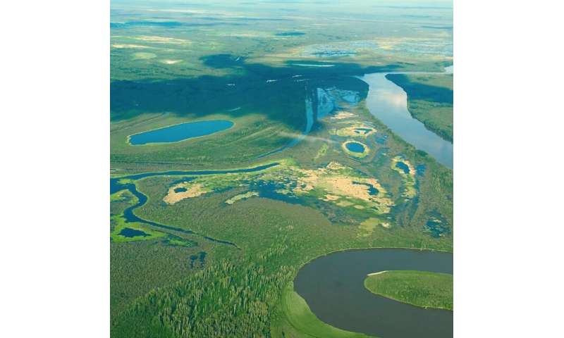
About 80 per cent of the Peace-Athabasca Delta is
contained within Wood Buffalo National Park,
one of Canada’s 20 UNESCO World Heritage Sites.
Credit: Mackenzie Schultz
Natural environmental processes—not upstream energy projects—are the primary cause of changing flood patterns in Alberta's Athabasca Delta, new research shows.
The research also shows there is no evidence to support the perception that energy projects have increased the amount of metal pollutants in the delta ecosystem.
Two recent studies, led by researchers at the University of Waterloo and Wilfrid Laurier University, found that natural changes to the river paths alongside climate impacts remain the dominant influences in the Athabasca Delta. In this area, recent lake drying and an increased perception of pollution have been widely attributed to the WAC Bennett Dam and oil sands developments, which are located upstream.
"It's clear from our research that lakes in the Athabasca Delta have been largely influenced by shifting river paths within the delta," said Mitchell Kay, a Ph.D. candidate at Waterloo and lead author of the studies. "Our findings also identify that concentrations of metals supplied by the Athabasca River have remained unchanged during the past 150 years."
"These findings provide important information to the Government of Canada, First Nations, and UNESCO, who are currently reviewing the World Heritage status of Wood Buffalo National Park, which houses a large portion of the delta."
About 80 percent of the Peace-Athabasca Delta is contained within Wood Buffalo National Park, one of Canada's 20 UNESCO World Heritage Sites. There are ongoing discussions between the Government of Canada, UNESCO and First Nations in the area about the conservation status of the park and whether it should be downgraded to a "World Heritage in Danger" site.
The studies analyzed cores of sediment that has settled at the bottom of floodplain lakes across the Athabasca Delta, providing a record of the flooding and metal concentrations over the past 150 years.
These records show that the major change to flooding patterns in the delta occurred after 1982, with some areas of the delta experiencing a marked increase in flooding, while other areas flooded less. The researchers attribute this change to a natural erosion event that occurred in 1982 when the Embarras River broke through its bank, substantially shifting the direction of river flow within the delta. This event is known as The Embarras Breakthrough.
"While there is broad consensus that the lake and river water levels have been declining in recent years, there is considerable controversy over the cause," said Roland Hall, a biology professor at Waterloo who has been studying the region for 20 years. "Our research clearly shows drying in much of the Athabasca Delta began in 1982, which corresponds to the Embarras Breakthrough event, not to operation of the WAC Bennett Dam, which began in 1968."
Further analysis of the sediment showed that metals of concern, found abundantly in the bitumen mined upstream of the delta, have remained within the natural range of concentrations that have existed for at least the past 150 years.
The study established baseline levels of six different metals of concern prior to oil sands development, and found no evidence supporting the common perception that pollution from the oil sands industry has reached the downstream Athabasca Delta.
This research was completed by Kay, Hall, collaborator Brent Wolfe of Wilfrid Laurier University, and members of their research teams, and published in the journals Environmental Research Communications and Science of the Total Environment.
More information: M L Kay et al. Bi-directional hydrological changes in perched basins of the Athabasca Delta (Canada) in recent decades caused by natural processes, Environmental Research Communications (2019). DOI: 10.1088/2515-7620/ab37e7
M.L. Kay et al. Evaluating temporal patterns of metals concentrations in floodplain lakes of the Athabasca Delta (Canada) relative to pre-industrial baselines, Science of The Total Environment (2019). DOI: 10.1016/j.scitotenv.2019.135309
Journal information: Science of the Total Environment
Studies find Alberta oil sands development not a major source of long-distance air and water pollution
by University of Waterloo
(Phys.org)—Oil sands development in northern Alberta isn’t polluting the nearby Peace-Athabasca Delta via the air and water to the extent many may believe, two recently published University of Waterloo research studies have found.
The research revealed that Alberta oil sands emissions haven’t increased the amount of metal and organic contaminants travelling via the atmosphere to the delta, located 200 km north of the oil sands industry. And it determined that oil sands mining activity hasn’t measurably increased the delivery of organic contaminants to shallow delta lakes via the Athabasca River.
The findings by researchers at the University of Waterloo and Wilfrid Laurier University counter the belief that human health, wildlife, and ecosystems are suffering as a result of long-distance transport of contaminants from the oil sands development.
“This evidence is essential in guiding responsible development of the oil sands while recognizing its true impact and benefits,” says Terry McMahon, dean of science. “It demonstrates the value that comprehensive research and the generation of knowledge can have on future decisions that affect our health, economy, and environment.”
One of the studies, “"Has Alberta oil sands development altered delivery of polycyclic aromatic compounds to the Peace-Athabasca Delta?"” published on September 26 in PLOS ONE, discovered the amount of organic contaminants that the Athabasca River carried to the downstream delta hasn’t increased above pre-development levels in sediments of a flood-prone lake.
Earlier in September, the study "“Has Alberta oil sands development increased far-field delivery of airborne contaminants to the Peace-Athabasca Delta?"”examining the transport of metal contaminants from the oil sands by air was published in Science of the Total Environment. It shows that key metals of concern including lead, antimony, arsenic, and mercury declined during the period when Alberta oil sands production was increasing dramatically. For these studies, researchers used lake sediment records spanning the past 200 years to provide critical knowledge of baseline, pre-development levels of metal and organic contaminant deposition, and to measure changes over time since the onset of oil sands development.
“The results of this study are significant in providing the knowledge needed for meaningful debates about the environmental exposure and effects of oil production at the world’s second-largest proven reserve,” says Roland Hall, principal investigator on the study and professor in the Department of Biology. “Indeed, our data show that toxic metals like arsenic and lead travelling via the atmosphere have declined dramatically in recent decades despite the growth of Alberta’s oil sands industry. And, we were unable to detect an increase in organic contaminants transported by the Athabasca River above natural levels delivered by floodwaters.”
The study may provide a foundation to map the footprint of emissions travelling via the air and water from oil sands operations over space and time, which could be a valuable contribution to Environment Canada’s new oil sands monitoring program.
Image: Athabasca oil sands from orbit
by European Space Agency
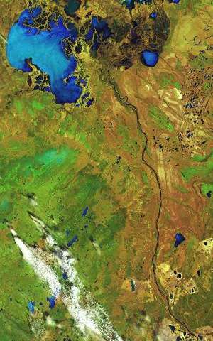
Credit: USGS/ESA
This Landsat-8 image covers a distance of over 350 km from top to bottom, all within Canada's Alberta province.
To the north, blue lake waters are visible, interspersed with rivers and creeks. This area makes up the world's largest freshwater inland river delta, where the Peace and Athabasca rivers converge on the Slave River and Lake Athabasca (the water body in the upper right).
Lake Claire to the left is also part of this delta system, and lies within the Wood Buffalo National Park – Canada's largest.
The lower half of the image is part of a wider area known as the Athabasca oil sands, which has the world's largest known reservoir of crude bitumen, which can be upgraded to crude oil using technology that extracts the oil from the soil using chemicals.
Boreal forests and peat bogs in this area are being destroyed by open-pit mining and hydraulic fracturing – 'fracking' – for heavy crude oil.
Boreal forests cover nearly half of the province, but about 20% has been disturbed by open-pit mining, some of which are visible in the lower-right. In addition to deforestation, these activities cause pollution and push wildlife from their preferred habitats.
This image, also featured on the Earth from Space video programme, is just one of more than 130 satellite images on display at the Palazzo delle Esposizioni in Rome, Italy, until 2 November.
As part of the 'My Planet from Space: Fragility and Beauty' exhibition, the collection takes you on a journey to some of the most beautiful and remote places on Earth, demonstrating the fragility of our planet and the challenges posed by human activities and climate change.
No comments:
Post a Comment