in western Canada in 15 hours
![]()
Amy Graff, SFGATE
July 1, 2021
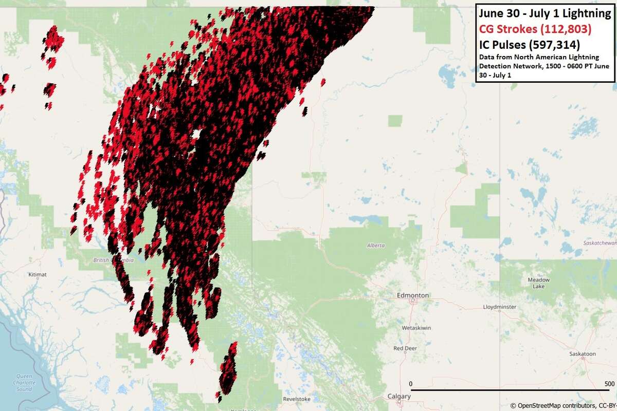
The North American Lightning Detection Network detected 710,177 lightning events across British Columbia and northwestern Alberta in about 15 hours, between 3 p.m. on June 30 and 6 a.m. on July 1.Chris Vagasky/Vaisala
Storm-producing fire clouds threw out hundreds of thousands of lightning strikes over wildfire-stricken British Columbia and northwestern Alberta provinces in Canada Wednesday and Thursday, bewildering meteorologists.
Chris Vagasky, a meteorologist with the company Vaisala, which maps lightning strikes around in the world, said the North American Lightning Detection Network sensed 710,177 lightning events across British Columbia and northwestern Alberta in about 15 hours, between 3 p.m. on June 30 and 6 a.m. on July 1.
Of those, 597,314 were in-cloud pulses, meaning the strikes didn't hit the ground. "Each in-cloud lightning 'strike' can be made up of multiple in-cloud pulses," Vagasky explained.
There were 112,803 cloud-to-ground strokes detected over the same area, he said.
Vagasky called the numbers "surprising" for Canada. "In studying lightning, there is always something interesting that comes up, whether it is lightning in a hurricane or volcano, or large numbers of lightning," he said. "As a whole, Canada doesn’t generally see a lot of lightning — about 90% less than the United States. In fact, the counts from yesterday are more what you would expect to see in a big day over lightning-prone regions like Texas or Oklahoma."
The numbers coming out of the lightning siege seem too big to be true, but Vagasky said the activity is measured with precision equipment.
Data produced by North American Lightning Detection Network is monitored nonstop and validated against rocket-triggered lightning, lightning to tall towers, and other lightning references.
"The network detects more than 95% of cloud-to-ground flashes with 100-meter accuracy," said Vagasky.
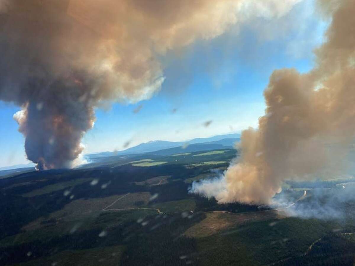
The majority of the strikes in western Canada were the result of pyrocumulonimbus clouds forming over the wildfires tearing across western Canada, which has also suffered from a sweltering heat wave in the past week.
On Thursday morning the British Columbia Wildfire Service listed 47 blazes across the region. In a fire burning 95 miles northeast of Vancouver, the entire village of Lytton evacuated. The mayor of the town of 250 people told CBC News on Thursday the whole town was on fire. Large blazes also burned north of Big White as well near Sparks Lake, according to CBC.
"Absolutely mind-blowing wildfire behavior in British Columbia," Dakota Smith, a scientist in Colorado, tweeted along with satellite imagery. "Incredible & massive storm-producing pyrocumulonimbus plumes."
"I've watched a lot of wildfire-associated pyroconvective events during the satellite era, and I think this might be the singularly most extreme I've ever seen," Daniel Swain, a climate scientist with the Institute of the Environment and Sustainability at UCLA, wrote on Twitter. "This is a literal firestorm, producing *thousands* of lightning strikes and almost certainly countless new fires."
These massive, mushroom-shaped clouds of hot, smoky air towering thousands of feet into the sky are caused by a natural source of heat such as a wildfire or volcano, according to NASA. Rising warm air from the fire carries water vapor, ash and smoke up into the atmosphere, forming clouds.
BC Wildfire Service shared an image of massive smoke plumes over the province: "#BCWildfire Service is responding to 2 wildfires ~18 km N of Big White. The Long Loch wildfire (K51040) and the Derrickson Lake wildfire (K51041) are in close proximity and estimated to be 300 ha combined in size. Smoke and fire behavior is making it difficult to confirm size."BC Wildfire Service
These clouds can become so intense that they create their own weather and emit lightning that can start new wildfires on the ground.
Neil Lareau, who studies wildfire-generated weather, said this appears to be the biggest pyrocumulonimbus event he has seen.
"At face value, I’m tempted to say this might be the upper end of what I’ve ever seen," said Lareau, a professor of atmospheric sciences in the department of physics at the University of Nevada at Reno. "There have been some significant pyrocumulonimbus clouds in British Columbia in 2017 as well as the Australian outbreak of 2020 and then the Creek Fire here in California."
Lareau closely followed a pyrocumulonimbus cloud that developed over the Creek Fire on Sept. 5, 2020, between Shaver Lake, Big Creek and Huntington Lake, Calif. Using data from the National Weather Service’s network of Doppler radars, Lareau created a model of the smoke plume that soared 55,000 feet in elevation.
He said the fires in western Canada have produced several clouds of this magnitude.
"Every year it’s one upping the year before, which is really horrifying," he said.
Amy Graff, SFGATE
July 1, 2021
%26utm_source%3Dfacebook.com%26utm_medium%3Dreferral&name=Fire%20clouds%20spark%20710%2C117%20lightning%20strikes%20in%20western%20Canada%20in%2015%20hours&description=One%20expert%20called%20the%20weather%20%26%23039%3Breally%20horrifying.%26%23039%3B&picture=https%3A%2F%2Fs.hdnux.com%2Fphotos%2F01%2F20%2F65%2F04%2F21188921%2F3%2FrawImage.png&redirect_uri=https%3A%2F%2Fwww.sfgate.com%2Fweather%2Farticle%2Fpyrocumulonimbus-British-Columbia-lightning-Canada-16287681.php%3Futm_campaign%3DCMS%2520Sharing%2520Tools%2520(Premium)%26utm_source%3DUTMSOURCE%26utm_medium%3DUTMMEDIUM)
The North American Lightning Detection Network detected 710,177 lightning events across British Columbia and northwestern Alberta in about 15 hours, between 3 p.m. on June 30 and 6 a.m. on July 1.Chris Vagasky/Vaisala
Storm-producing fire clouds threw out hundreds of thousands of lightning strikes over wildfire-stricken British Columbia and northwestern Alberta provinces in Canada Wednesday and Thursday, bewildering meteorologists.
Chris Vagasky, a meteorologist with the company Vaisala, which maps lightning strikes around in the world, said the North American Lightning Detection Network sensed 710,177 lightning events across British Columbia and northwestern Alberta in about 15 hours, between 3 p.m. on June 30 and 6 a.m. on July 1.
Of those, 597,314 were in-cloud pulses, meaning the strikes didn't hit the ground. "Each in-cloud lightning 'strike' can be made up of multiple in-cloud pulses," Vagasky explained.
There were 112,803 cloud-to-ground strokes detected over the same area, he said.
Vagasky called the numbers "surprising" for Canada. "In studying lightning, there is always something interesting that comes up, whether it is lightning in a hurricane or volcano, or large numbers of lightning," he said. "As a whole, Canada doesn’t generally see a lot of lightning — about 90% less than the United States. In fact, the counts from yesterday are more what you would expect to see in a big day over lightning-prone regions like Texas or Oklahoma."
The numbers coming out of the lightning siege seem too big to be true, but Vagasky said the activity is measured with precision equipment.
Data produced by North American Lightning Detection Network is monitored nonstop and validated against rocket-triggered lightning, lightning to tall towers, and other lightning references.
"The network detects more than 95% of cloud-to-ground flashes with 100-meter accuracy," said Vagasky.
The majority of the strikes in western Canada were the result of pyrocumulonimbus clouds forming over the wildfires tearing across western Canada, which has also suffered from a sweltering heat wave in the past week.
On Thursday morning the British Columbia Wildfire Service listed 47 blazes across the region. In a fire burning 95 miles northeast of Vancouver, the entire village of Lytton evacuated. The mayor of the town of 250 people told CBC News on Thursday the whole town was on fire. Large blazes also burned north of Big White as well near Sparks Lake, according to CBC.
"Absolutely mind-blowing wildfire behavior in British Columbia," Dakota Smith, a scientist in Colorado, tweeted along with satellite imagery. "Incredible & massive storm-producing pyrocumulonimbus plumes."
"I've watched a lot of wildfire-associated pyroconvective events during the satellite era, and I think this might be the singularly most extreme I've ever seen," Daniel Swain, a climate scientist with the Institute of the Environment and Sustainability at UCLA, wrote on Twitter. "This is a literal firestorm, producing *thousands* of lightning strikes and almost certainly countless new fires."
These massive, mushroom-shaped clouds of hot, smoky air towering thousands of feet into the sky are caused by a natural source of heat such as a wildfire or volcano, according to NASA. Rising warm air from the fire carries water vapor, ash and smoke up into the atmosphere, forming clouds.
BC Wildfire Service shared an image of massive smoke plumes over the province: "#BCWildfire Service is responding to 2 wildfires ~18 km N of Big White. The Long Loch wildfire (K51040) and the Derrickson Lake wildfire (K51041) are in close proximity and estimated to be 300 ha combined in size. Smoke and fire behavior is making it difficult to confirm size."BC Wildfire Service
These clouds can become so intense that they create their own weather and emit lightning that can start new wildfires on the ground.
Neil Lareau, who studies wildfire-generated weather, said this appears to be the biggest pyrocumulonimbus event he has seen.
"At face value, I’m tempted to say this might be the upper end of what I’ve ever seen," said Lareau, a professor of atmospheric sciences in the department of physics at the University of Nevada at Reno. "There have been some significant pyrocumulonimbus clouds in British Columbia in 2017 as well as the Australian outbreak of 2020 and then the Creek Fire here in California."
Lareau closely followed a pyrocumulonimbus cloud that developed over the Creek Fire on Sept. 5, 2020, between Shaver Lake, Big Creek and Huntington Lake, Calif. Using data from the National Weather Service’s network of Doppler radars, Lareau created a model of the smoke plume that soared 55,000 feet in elevation.
He said the fires in western Canada have produced several clouds of this magnitude.
"Every year it’s one upping the year before, which is really horrifying," he said.
Lightning strikes surge in British Columbia
Yacob Reyes AXIOS
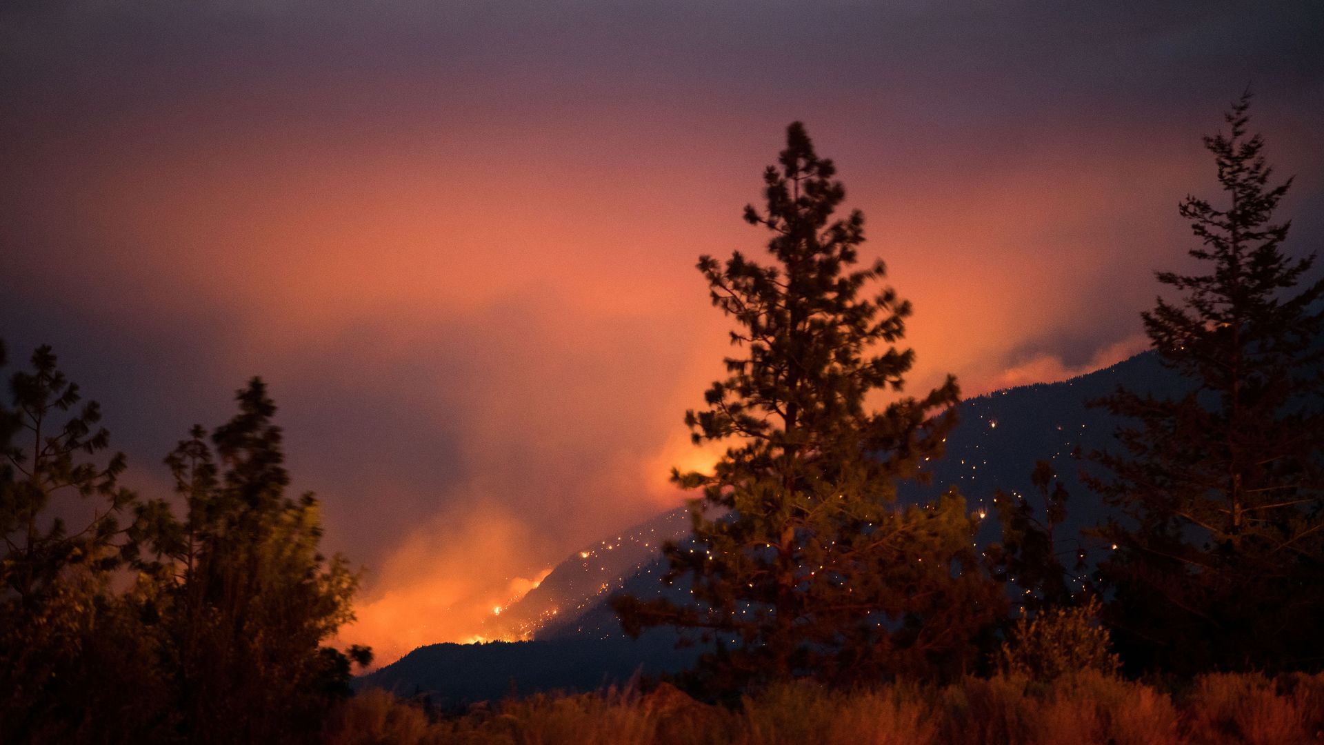
Wildfire burns above the Fraser River Valley near Lytton, British Columbia, Canada, on July 2. Photo: James MacDonald/Bloomberg via Getty Images.
Lightning strikes in Western Canada have surged over the past few days, triggered in part by an unprecedented heatwave that also induced wildfires, Reuters reports.
The big picture: British Columbia, which usually accounts for about 5% of Canada's yearly lightning strike total, reported its annual number in less than 48 hours.
A meteorologist, who tracks lightning, noted about 710,000 lightning events in British Columbia and Alberta Wednesday.
Driving the news: The onslaught of wildfires enduring in the area has resulted in a high moisture level in the atmosphere.
The moisture ultimately fuels its own towering thunderstorms and a surge of lightning strikes that itself has caused several forest fires, per Reuters.
The fires are expected to burn through 247,105 acres by the end of the weekend, a higher figure than in previous years.
Go deeper: Ferocious wildfires destroy British Columbia town amid historic heat
Yacob Reyes AXIOS
Wildfire burns above the Fraser River Valley near Lytton, British Columbia, Canada, on July 2. Photo: James MacDonald/Bloomberg via Getty Images.
Lightning strikes in Western Canada have surged over the past few days, triggered in part by an unprecedented heatwave that also induced wildfires, Reuters reports.
The big picture: British Columbia, which usually accounts for about 5% of Canada's yearly lightning strike total, reported its annual number in less than 48 hours.
A meteorologist, who tracks lightning, noted about 710,000 lightning events in British Columbia and Alberta Wednesday.
Driving the news: The onslaught of wildfires enduring in the area has resulted in a high moisture level in the atmosphere.
The moisture ultimately fuels its own towering thunderstorms and a surge of lightning strikes that itself has caused several forest fires, per Reuters.
The fires are expected to burn through 247,105 acres by the end of the weekend, a higher figure than in previous years.
Go deeper: Ferocious wildfires destroy British Columbia town amid historic heat
No comments:
Post a Comment