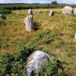
Danish antiquarian Ole Worm conducted the first survey of the Kalvestene in 1650.
JENNIFER OUELLETTE - 7/1/2021, 3:11 PM
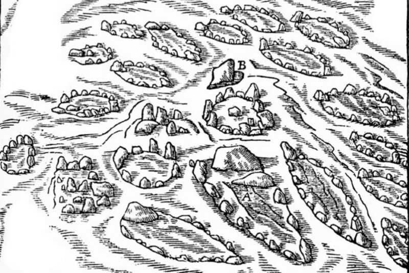
In 1650, a Danish physician and antiquarian named Ole Worm conducted the first survey of a Viking cremation burial site known as the Kalvestene. Worm created a map of the locations of all the "ship settings"—stones arranged in the shape of vessels—marking the graves. Now, a team of archaeologists has compared its own detailed surveys with Worm's original illustrations and may have discovered two new ship settings that are consistent with that centuries-old survey, according to a recent paper published in the Journal of Island and Coastal Archaeology.
Vikings typically buried their dead, along with the deceased's material possessions, within a wooden ship. They then covered the grave with dirt to create a raised earthen mound. The Kalvestene, on a small island called Hjarnø, is one of about 25 such sites in Denmark. Even though it's a relatively small grave field, the Kalvestene (literally translated as "the calf stones") was nonetheless well-known in the region. It is first mentioned in the 12th-century treatise Gesta Danorum ("The History of the Danes" or "Deeds of the Danes") by Danish theologian Saxo Grammaticus, and there are many other references throughout medieval and early modern texts.
"It's such an interesting site, and the fact that it is referred to in medieval sources—when other, larger monuments aren't—demonstrates it was a significant site, too," co-author Erin Sebo of Flinders University in Adelaide, Australia, told Ars.
Worm's 1650 drawings—the first recorded survey of the site—indicate that 34 stone settings once stood at Kalvestene, although only 10 remain today. (Residents likely removed the other settings over the centuries for various repurposes.) In 1935, iron fragments that may have once been part of a damasked iron sword were found. The following year, archaeologist H.C. Broholm did a scientific excavation of two of the graves for the National Museum in Copenhagen. He carefully numbered the 10 surviving ship settings but mostly just found a few burnt bones, charcoal, and pottery shards dating back to 600-900 AD.Advertisement
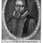
In 2009, Tatiana Smekalova conducted a limited magnetic survey of the Kalvestene on behalf of the Horsens Museum, hoping to locate the additional graves documented by Worm, in addition to any other buried remains. Nothing was found. For this latest research, Sebo and her colleagues wanted to determine the accuracy of Worm's 1650 survey and learn more about how the Hjarnø ship settings compared to other such sites. They also wanted more insight into why the Kalvestene was so well-known to contemporaries. Sebo et al. extended their analysis to incorporate medieval records, aerial photogrammetry, and lidar data from an archaeological survey conducted by the Moesgaard Museum in 2018.
Distribution of Danish single-ship settings and grave fields.
E. Sebo et al., 2021
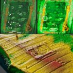
The Kalvestene, cremation burial site of the Viking age on the island of Hjarnø, Denmark.
Erik Christensen / CC BY-SA 3.0
Portrait of Ole Worm, "Fasti Danici," 1626.
Wellcome Library, London/CC BY 4.0
H.C. Broholm's site plan of the various ship settings, 1937.
E. Sebo et al., 2021
Tatiana Smeklova's 2009 magnetic survey of the Kalvestene.
Smeklova, 2009/Horsens Museum
(left) Drone orthophoto of the Kalvestene. (right) Digital elevation model.
E. Sebo et al., 2021
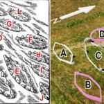
Digital elevation model of the Kalvestene overlaid with Broholm's plan (top left), with the possible locations of two additional graves marked with white circles (top right and bottom).
E. Sebo et al., 2021
Comparison of Ole Worm's drawing with photogammetic model. Possible "new" settings are marked in pink.
E. Sebo et al., 2021
Previous SlideNext Slide


The researchers found that the Kalvestene is unusual among Viking burial sites because its stone settings are exclusively shaped like ships (this arrangement is believed to be a tribute to the Norse god of wind and weather, Njord (or Njörðr), whose symbol was a ship). Other Danish sites from the same period feature settings shaped like circles, ovals, triangles, and ships.
The researchers also identified two new raised areas that they believe could be additional burial sites. "One appears to be a typical ship setting, and the second remains ambiguous," said Sebo. "But it's impossible to know without excavation and further survey."
Per Saxo's medieval treatise, the Kalvestene's stone settings were arranged to honor a peasant-turned-king named Hiarni. He was purportedly the author of a poem about his regal predecessor, Frothi, who died in battle on the island. Hiarni's title was challenged, however, and he was ultimately killed and buried on the island. The authors concluded that there is no evidence Saxo's account is accurate or that the island was named after a peasant-king named Hiarni, who likely never existed. Instead, linguistic evidence suggests Hiarni was invented and named after the island. What's significant is that Saxo was aware of a grave monument on Hjarnø.Advertisement
"Most monuments of this kind are designed to honor the power of an important individual," said Sebo. "However, our study demonstrates that the site had a community focus and that the people of Hjarnø had a much flatter, more egalitarian social structure."
Sebo et al.'s findings suggest a significant Swedish presence on the island and regular contact and trade between Sweden and Denmark. Medieval ships would have passed the island frequently on their trade routes, and artifacts recovered from a hoard in 2017 provided evidence that foreign traders likely visited the island. Of course, the borders between the two countries shifted throughout the medieval period, so there were periods when parts of modern Sweden were under Danish rule.
“Not borders, but distance”
"The issue is not borders, but distance," said Sebo. She noted that Kalvestene was built near several Danish centers of power, all of which can be reached by land, while their Swedish counterparts were farther away and required water travel. "Our study demonstrates that maritime links were strong for the Hjarnø community and reflect a profoundly maritime culture, in which the land is more of a barrier than the sea," she said. This finding suggests that "close connections between communities were based on a range of factors and not necessarily simple proximity."
As for Worm's 1650 illustrations, this study doesn't offer definitive proof of their accuracy, despite the discovery of two possible gravesites in keeping with his centuries-old survey. However, "while this study is unable to offer a conclusive understanding of the origins of the Kalvestene, it demonstrates the value of combining source criticism and analysis with archaeological data to contribute toward greater understanding about the site," said co-author Jonathan Benjamin, also from Flinders University.
DOI: Journal of Island and Coastal Archaeology, 2021. 10.1080/15564894.2021.1900955 (About DOIs).
No comments:
Post a Comment