It’s possible that I shall make an ass of myself. But in that case one can always get out of it with a little dialectic. I have, of course, so worded my proposition as to be right either way (K.Marx, Letter to F.Engels on the Indian Mutiny)
If anyone is still wondering whether the Trump Administration’s goal of $50 per barrel oil price would hurt American drillers, the answer came this week from oil tycoon and wildcatter Harold Hamm, who is ceasing drilling operations in North Dakota for the first time in decades.
“This will be the first time in over 30 years that Harold Hamm has not had an operation with drilling rigs in North Dakota,” Hamm, who founded Continental Resources, told Bloomberg in a telephone interview published on Friday.
“There’s no need to drill it when margins are basically gone,” the billionaire oil magnate and Trump donor said.
Hamm first proved in the Bakken shale play in North Dakota that hydraulic fracturing could help unlock huge oil resources in horizontal drilling. The rest is history.
The U.S. shale industry has survived two market crashes in the past decade, returning stronger each time and helping U.S. crude oil production hit a record of over 13 million barrels per day.
But the breakevens in the shale plays are close to $60 per barrel WTI price. In recent months, the U.S. benchmark price has rarely topped $60 a barrel for a sustained period.
In the Bakken, the breakeven for drilling a well is now on average at least $58 per barrel, up by 4% from a year ago, as costs have increased, a BloombergNEF report has found.
President Donald Trump’s major campaign pledge of cheap oil at about $50 per barrel would reduce drilling activity in all the major basins, including the most resilient play, the Permian, analysts say.
Hamm told Bloomberg that “A lot of people are assessing their activity in all the basins.”
Lower 48 oil production will stall in 2026 for the first time since the pandemic, Wood Mackenzie said last month in its preview of what to expect in the U.S. onshore basins.
In the December Dallas Energy Survey, which encompasses mostly the Permian, one executive at an exploration and production company said that “Decreasing oil prices are making many of our firm’s wells noneconomic.”
Global geothermal spending is rising sharply, with capex expected to grow 20% annually through 2030 and consistent cost structures across regions.
Different markets emphasize different uses: Europe focuses on district heating, while Asia and North America prioritize power generation and emerging enhanced geothermal systems.
Costs for heating projects are roughly half those of geothermal power due to simpler surface infrastructure, guiding investment and policy decisions.
Global geothermal investment is entering a period of accelerated growth, with capital expenditure (capex) expected to climb about 20% annually through 2030, according to Rystad Energy’s latest geothermal economics model. This momentum comes as geothermal energy, produced by tapping heat from deep within the earth, is no longer defined only by mature hubs in Southeast Asia and the US. Interest in regions such as Africa and Europe has been building at a measured pace, contributing to a steady broadening of activity worldwide. Meanwhile, the distribution of spending remains relatively stable across development categories due to consistent cost structures in drilling, surface facilities and steamfield infrastructure.
Currently, just over half of total spending goes toward surface facilities, while an estimated 47% is directed to subsurface work and about 2% is allocated to pre-final investment decision (FID) activities. This distribution is broadly consistent across most markets, making this cost structure a defining aspect of geothermal development. Even the relatively small share devoted to pre-FID work can represent a significant risk, as early exploration determines whether a project advances or is halted altogether. The distribution of costs helps explain why project timelines and financing needs remain relatively uniform across regions, even as overall activity grows.
Global investment in geothermal energy is gaining momentum as more projects move toward FID. Our research shows that geothermal energy is increasingly being tailored to regional needs, reflecting its dual role as a source of clean, reliable power and a provider of heat. In the US, growth is being driven by the expansion of enhanced geothermal systems (EGS) and rising demand for baseload power from data centers. Europe, on the other hand, is focusing on decarbonizing heat, while Southeast Asia is turning to geothermal to meet growing electricity demand. The sector’s longer-term potential in cooling applications is growing as well, a market set to expand alongside global data center activity that’s less considered,
Alexandra Gerken, Vice President, New Energies Analysis, Rystad Energy
When comparing geothermal deployment across continents, Europe stands out as a market dominated by district heating, driven by ambitious decarbonization targets and extensive municipal heating networks. In contrast, Asia, particularly Indonesia, and North America focus primarily on electricity-generating geothermal projects, reflecting strong baseload power needs and abundant geological resources. This divergence shapes both installed capacity and investment patterns. Europe relies more on subsurface development for heating despite lower surface infrastructure costs, while Asia and North America exhibit a more balanced demand between drilling and surface power facilities.
Beyond regional deployment differences, geothermal energy’s role as a clean, reliable source of baseload power is gaining importance. EGS reduces site dependence by requiring only hot rock rather than aquifers, unlocking additional clean power potential and providing stable baseload heat. The technology also shows long-term promise in cooling applications. Pilot projects in the Middle East are exploring its use for data centers, including the UAE’s first geothermal cooling plant, the G2COOL project.
Further research from Rystad Energy, using a bottom-up approach, examines each geothermal asset and its individual cost components, including drilling operations, equipment, and surface infrastructure, rather than focusing solely on total project costs or subsurface development. Geothermal projects are primarily used for district heating systems or power generation, and the resource stands out as one of the few energy sources capable of providing clean baseload power, meaning it can deliver a steady and reliable energy supply.
Costs are often expressed in “dollars per watt,” which indicates the investment required to produce one watt of energy. On this basis, district heating projects generally require about half the investment of geothermal power plants. This difference arises because heating systems do not require expensive turbine sets or complex surface infrastructure, which are essential for electricity generation. In contrast, geothermal power projects involve more extensive facilities and intricate designs, resulting in roughly $6 per watt for power versus around $3 per watt for district heating.
These cost differences are important for policymakers, investors, and developers when assessing project feasibility, choosing technologies, and planning long-term geothermal development. Understanding these relative costs helps guide decisions on which projects to prioritize and how to maximize the value of geothermal resources.
Two years ago, Ovintiv, a multinational oil and gas company, announced it would expand fracking for gas at a new site built on a hill about a kilometre from Richard Kabzems's home in Farmington, B.C.
CBC Sat, February 1, 2025
(Samuel Martin/CBC - image credit)
Standing in his living room, Richard Kabzems brandishes a thick binder stuffed with letters and notes of his two-year fight to stop fracking wells near his home in Farmington, B.C.
Ovintiv, a multinational oil and gas company, announced two years ago that it would expand fracking for gas at a new site built on a hill about a kilometre from Kabzems's home in the rural Lebell subdivision. The BC Energy Regulator (BCER) approved the permit.
Over the last 24 months, Kabzems and his wife, Sandy Burton, have written six detailed letters to the gas company opposing the project, and another series of emails and letters to the provincial regulator.
But drilling is scheduled to begin on Feb. 9, on the first of a projected 24 wells at the site.
"We are bearing the risk, and they are saying, 'Don't worry,'" Kabzems said.
He is, in fact, worried. That's because in 2024, the number of magnitude 3 or higher earthquakes linked to hydraulic fracturing and the underground storage of its wastewater reached a record high in the Montney Formation, a gas-rich area straddling northeastern B.C. and northwestern Alberta.
According to monitoring data from Natural Resources Canada, there were 34 recorded earthquakes at magnitude 3 and above (M>3.0) in Montney, more than three times the amount 10 years ago.
The correlation between oil and gas activity and induced earthquakes is well-documented around the world.
Magnitude 3 quakes can be felt and even cause damage, according to seismicity experts, depending on where they occur. Every step up in magnitude releases 10 times the amount of energy.
Kabzems and Burton have felt quakes before — from fracking farther away than the new drill site.
Over the last 24 months, Richard Kabzems, right, and his wife, Sandy Burton, left, have written six detailed letters to the gas company opposing the Farmington, B.C., fracking project, and another series of emails and letters to the provincial regulator.
(Jill English/CBC)
"It felt like a truck was hitting the side of our house, and the engine rumbling — this deep, low rumbling — and things would shift," he said, recalling a series of quakes four years ago.
But Kabzems and Burton's home insurer notified them in June 2023 that earthquake insurance would be excluded from their policy.
Allan Chapman, a former senior geoscientist with the B.C. Oil and Gas Commission who analyzed the data, concluded the frequency of significant earthquakes will only increase as fracking expands in the Peace River area.
Kabzems says the first few times he experienced a quake, "you didn't know what was happening; You didn't have any experience. And again, with earthquakes, you just don't know when they will occur."
Industry acknowledges risk
Hydraulic fracturing in the Montney Formation involves drilling deep vertically and then boring horizontally as much as four kilometres. A mixture of water, sand and chemicals is then forced into the well bore at high pressure, splitting the rock to release gas or oil.
If the process hits a fault, it can cause seismic activity.
In B.C, the industry has acknowledged the risk. But Ovintiv's website states "the occurrence and risk of seismicity is generally very low," and says it has a framework for "proactively addressing seismic activity through partnerships with independent research institutions and regulatory agencies to minimize any associated or perceived risks.
The company has hosted consultation sessions with residents in Kabzems's subdivision, but declined an interview with CBC News.
The incidence of stronger quakes isn't confined to the Peace River region. In both B.C. and Alberta's gas and oil areas, the number of higher-magnitude earthquakes has gone up.
"In 2021, we saw about 60 earthquakes a year, and in 2024, we were up to 160," said Gail Atkinson, a consulting seismologist and former professor at Western University in London, Ont.
Atkinson, who has studied "induced seismicity" for decades, says there's a direct link between the rising number of quakes and stronger seismic events.
"Most of the quakes that you get are smaller magnitudes," she said. But more earthquakes means a higher incidence of quakes at every magnitude, including strong ones.
In November 2018, construction workers building the Site C dam on Peace River were forced to evacuate the work site because of an induced quake measuring magnitude 4.6. (Samuel Martin/CBC)
"The more fracking we do, the more oil and gas we take, the more earthquakes we will have. And the larger is the chance that one of those earthquakes will have an undesirable consequence," she said. "It's a trade-off."
In November 2018, construction workers building the Site C dam on Peace River were forced to evacuate the work site because of an induced quake measuring 4.6.
Atkinson urges regulators to pay more attention to the rising risks and create larger buffer zones.
"I think that for critical infrastructure, like major dams [...] it makes far more sense to have exclusion zones for fracking around high-value targets," she said.
'That's a big one'
The urgency to address the risk is exacerbated by a renewed boom in fracking in northeastern B.C. to feed a new, hungry pipeline just starting to send natural gas west to a LNG terminal in Kitimat, B.C. The terminal will liquify natural gas for export, for the first time opening overseas markets to Canadian gas.
It's projected the pipeline will carry two million cubic feet of gas per day, and that production in the Montney could double in the next 20 years.
U.S. President Donald Trump's invocation to "drill, baby, drill," suggests he'll support more production of oil and gas. His nominee for secretary of energy, Chris Wright, the CEO of Liberty Energy, is bullish on fracking.
Last July, 60 tremors in one week — ranging from small to significant — shook the area around Snyder, Texas.
Jay Callaway was on duty as the city's emergency management co-ordinator on July 26.
"It sounded like a herd of cattle coming. And then it was just an eerie feeling. And then it sounded like the cattle was leaving," he told CBC, standing in the local fire department building.
His first thought was: "There's a big one." It was magnitude 5.1.
Jay Callaway was on duty as the emergency management co-ordinator last July, when 60 tremors in one week shook the area around Snyder, Texas. (Hugo Levesque/CBC)
Callaway started getting calls.
"Reports of cracks in walls, driveways, foundations — [that] was the main damage," he said. An emergency team had to repair a crack in a city water line.
The quakes also popped up on monitors at a lab at the University of Texas in Austin, where seismologist Alexandros Savvaidis can watch earthquake activity in real time.
Normally, he says, there are a couple hundred earthquakes a day — most of them small, less than magnitude 1.5.
While the oil industry itself was slow to admit any connection between fracking and earthquakes, Savvaidis was recruited from Europe to help run TexNet, a state-funded program to monitor seismic events from the Texas oil patch.
A few years ago, Alexandros Savvaidis was recruited from Europe to help run TexNet, a state-funded program to monitor seismic events from the Texas oil patch.
(Hugo Levesque/CBC)
They now have 200 sensors around the state.
"When I came here in 2016, [the producers] were in denial. That was really not the best thing," said Savvaidis. "I think in the last five years, it's been accepted by the industry and the public."
Midland's gamble
The industry's hub is Midland, in the oil-rich Permian Basin. Oil exploration is so embedded in the culture, it's even the location of the new Paramount+ drama Landman.
In Midland, drilling and fracking is so pervasive, it now happens in town. A tall rig towers over a parking lot and strip mall. Underneath, horizontal wells will extend far beyond the pad itself, stretching several kilometres under the city.
In the Texas town of Midland, drilling and fracking is so pervasive, a tall rig towers over a parking lot and strip mall. (CBC)
"This operator, they have a belief that they just get better wells where no one's drilled before," said Steve Melzer, an oil industry consultant and engineer. "He's betting that this is fertile ground that hasn't been touched, because it was in town."
But Melzer recognizes the seismic activity this past summer is posing a risk to industry, too.
Fracking relies on enormous amounts of water, which needs to be stored. According to Savvaidis, the water storage is causing most of the induced-earthquakes in Texas.
"If we have another big one, especially near an urban centre, it's going to impact us big-time," Melzer said. "Hopefully we'll be able to manage it, engineer more uses of that water, instead of putting it back in the ground."
Storing the liquid is delicate, and the wrong pressure, depth or quantity can trigger seismic activity. It's a problem Melzer is focused on solving, both by improving the process and looking at other uses for the water, to reduce underground storage volumes.
"If we can't reduce the water volumes going into the [underground] formations, we're going to have to slow drilling down."
Steve Melzer, an oil industry consultant and engineer in Texas, says the seismic activity this past summer is posing a risk to the industry, too. (Jill English/CBC)
Warning system
Kabzems has officially appealed the permit for the fracking pad in Farmington, B.C., but he's had no response since October. Meanwhile, construction continues.
The BC Energy Regulator points to safeguards such as the 35 seismic monitors in the Montney area, and a "traffic light system" that warns the regulator of seismic activity. At levels of magnitude 3 and above, operators must stop fracking and investigate.
Gail Atkinson says the measures are useful but not foolproof, because bigger earthquakes aren't always preceded by smaller ones.
Leading Canadian seismologist Gail Atkinson has been studying induced-earthquakes in B.C. (Dillon Hodgin/CBC)
"If you have one that just lights up right away and gives you a magnitude 4 or 5 as its very first salvo, the traffic light will not work," she said.
"I don't blame the oil and gas companies for following the existing regulations. They have a business. They have their own models of how they look at risk," she said.
"It's really up to the regulators and the government to protect populations and also to protect the industry as a whole to ensure that we don't end up with an environmental catastrophe as a result of an earthquake being generated in the wrong place."
Monday, July 24, 2023
FRACKQUAKES
Push to build more CO2 pipelines and store vast amounts of the gas underground in Illinois raises alarms about safety regulations Zbigniew Bzdak/Chicago Tribune/TNSMore
Nara Schoenberg, Chicago Tribune Sun, July 23, 2023
For years, the carbon dioxide pipeline snaked through the fields and forests of Yazoo County, Mississippi, going largely unnoticed.
But that changed forever on a winter evening in 2020.
Under pressure from heavy rains and a landslide, the pipeline split in two, roaring like a jet engine, carving a 40-foot crater into the ground, and sending an invisible cloud of dangerous carbon dioxide vapor toward the tiny village of Satartia. In a scene rescue workers would later compare to a zombie movie, cars died in the middle of the road, their engines starved of oxygen. Drivers fled, leaving their hazard lights blinking in the dust and darkness.
A sheriff’s deputy working without an oxygen mask grew increasingly unsteady and short of breath, until he himself had to be rescued, according to Warren County fire coordinator Jerry Briggs.
Closer to the deafening roar of the escaping gas, Briggs and his team spotted a stalled-out car that was still in drive, the driver’s foot resting on the brake, the windows closed. All three of the men inside were unconscious.
“It was miraculous that they survived,” Briggs said.
While rare and up until now nonfatal, accidents such as the one that night in Satartia loom large as the Midwest considers the health and safety issues raised by proposals to build massive new carbon dioxide pipeline projects, including Omaha-based Navigator CO2′s 1,350-mile network spanning Illinois, Iowa, Minnesota, Nebraska and South Dakota.
The projects aim to prevent planet-warming CO2 from entering the atmosphere by capturing it during industrial processes, compressing it into a fluid, transporting it in steel pipelines and injecting it deep underground into naturally occurring rock formations where it will be trapped — ideally for thousands of years.
Navigator says this can be done safely and points to thousands of miles of CO2 pipeline already in use in the United States, mostly by the oil industry, which uses carbon dioxide to boost production.
But opponents, including environmentalists and landowners, say a new generation of massive, climate-oriented CO2 pipeline projects such as Navigator’s should be put on hold until government officials can address “alarming” gaps in health and safety regulations. Among the gaps:
There is no state or federal limit on how close pipelines carrying a potentially suffocating gas can be placed to a home, school or hospital.
There is no requirement that an odorant be added to the CO2 to alert the public to a leak, as is done with natural gas.
There is no limit on the impurities that are allowed in the carbon dioxide, despite the potential for pipeline corrosion and health hazards in the event of a leak.
There is no requirement that pipeline companies use a specific method to map potential accident hazard zones, although one standard approach — which failed in Mississippi — doesn’t take complex topography into account.
“It’s like the Wild Wild West,” said Pam Richart, co-director of the Champaign-based environmental group Eco-Justice Collaborative and lead organizer of the Coalition to Stop CO2 Pipelines, of the current state of regulation. “It’s whatever (the pipeline companies) say is going to go.”
Adding to Illinoisans’ health and safety concerns are the unknowns: No one has ever stored as much CO2 underground as Navigator proposes — up to 15 million metric tons a year in central Illinois — and while the risks are theoretically low, opponents say the stakes are high.
They’re worried about drinking water contamination due to CO2 leakage and the potential for tiny microearthquakes as subterranean pressures rise.
In May, more than 150 environmental and advocacy groups — including the Center for Biological Diversity, Eco-Justice Collaborative and Food & Water Watch — signed a letter to President Joe Biden calling for a moratorium on new CO2 pipelines until federal regulators complete their work on new safety standards.
Calls for state and federal moratoriums come at a time when the nation faces a potential “tsunami” of new CO2 pipelines, driven by billions of dollars in federal incentives aimed at combating climate change, according to a 2022 report from the nonprofit Pipeline Safety Trust.
In the Midwest, proposed projects from other companies include the 260-mile Wolf Carbon Solutions pipeline in Illinois and Iowa and the 2,000-mile Summit Carbon Solutions pipeline in Iowa, Minnesota, North Dakota, South Dakota, and Nebraska.
The United States, currently home to about 5,300 miles of CO2 pipeline, could have more than 68,000 miles by 2050, according to a Princeton University report.
Navigator declined to do a phone interview but said in writing that current state and federal pipeline regulations are sufficient.
“The United States has thousands of miles of regulated, liquid CO2 pipelines that have been operating safely for years,” the company wrote. “There are many instances in which Navigator is exceeding the federal safety stipulations outlined in (CO2 pipeline) regulations.” ‘A potential bomb’
Karen Sanders greeted a visitor from the wide porch of her three-bedroom home in rural Nokomis, 200 miles southwest of Chicago.
Petunias dangled from hanging flower baskets, drawing the occasional hummingbird. A sign just inside the front door said “Grateful, thankful, blessed.”
This is the “forever home” Sanders and her husband, Eric, a farmer, built 25 years ago on 5 acres of family land. Her late father, a carpenter, helped with construction, as did her father-in-law, a retired farmer who used a scoop tractor to lift shingles to the roof.
She and her husband raised their two grown children here.
But Sanders, 54, a community college vice president, said she won’t stay if Navigator succeeds in its plan to run a high-pressure carbon dioxide pipeline about 400 yards from her home in a farm field owned by her family.
“It’s a huge decision,” said Sanders. “But we refuse to live next to what we consider a potential bomb.”
Of all the pipeline concerns facing Illinois landowners, none has caused more anguish than the prospect of a rupture.
“Ninety-nine percent of my family lives just miles from us,” said Sabrina Jones, 35, of Nokomis, who has helped organize the local pipeline opposition, along with her husband, Ralph. “If and when that pipeline ruptures, it would suffocate all of us.”
Opponents could be forced to allow pipelines to run under their properties if Navigator’s application for eminent domain is approved by the Illinois Commerce Commission. Under eminent domain, private property can be taken for public use against the owner’s wishes but with proper compensation.
At the very least, landowners want setbacks — or required minimum distances from homes, schools and other places where people gather. But the federal Pipeline and Hazardous Materials Safety Administration doesn’t require setbacks for CO2 pipelines.
“Nothing prevents them from putting (a pipeline) right next to your house,” said pipeline safety consultant Richard Kuprewicz, author of an influential Pipeline Safety Trust report on regulatory gaps.
The pipeline proposal still needs the approval of the Illinois Commerce Commission and permits from the U.S. Army Corps of Engineers and the Environmental Protection Agency. In addition, the project will need more buy-in from landowners along the proposed route; in June only about 13% had agreed to allow Navigator to run the underground pipes through their property, according to testimony before the commerce commission.
A spokesperson for Gov. J.B. Pritzker issued a written statement saying the governor does not comment on proposals that are pending before the Illinois Commerce Commission.
“The governor has worked to appoint qualified individuals to the commission and believes in their work to ensure adequate, efficient, reliable, safe and least-cost public utility services, protect Illinois consumers and residents, and make the best decisions for the state based on current law,” the statement said.
In its last session, the Illinois legislature considered a bill — supported by Navigator critics — that would require that CO2 pipelines be placed at least a mile from homes, and at least 2 miles from hospitals and schools. There’s an exception for companies that use more sophisticated (and expensive) computer modeling to determine potential hazard zones and then route their pipelines accordingly.
Studies of existing U.S. CO2 pipelines have found that accidents leading to the release of significant amounts of CO2 are infrequent.
Accidental leaks occur at a rate of 1 incident per 1,600 miles of pipeline per year, according to a 2022 study in the Journal of Loss Prevention in the Process Industries, and many of those accidents are leaks from holes and unintended releases from relief valves. The study, based on U.S. government data, found that only 3% of leaks were serious enough to be classified as ruptures.
But the 2020 pipeline rupture in Mississippi served as a reminder that when larger accidents do occur, they can be serious.
“People were dropping like flies all over the place,” said Kuprewicz, referring to those who passed out. “I’m not here to scare people. It’s just the reality. I don’t fear this stuff, but it demands great respect.”
Two hundred people — including those prevented from driving through the area — were evacuated because of a rupture that occurred due to a landslide after heavy rains, according to a government report. The soil advanced downhill toward the pipeline, creating pressure and causing a weld to fail.
Federal regulators fined the pipeline operator, Texas-based Denbury Gulf Coast Pipelines, nearly $2.9 million. Among the alleged violations listed in a March consent agreement: Denbury failed to review its procedures for monitoring and addressing geohazard risks to determine their effectiveness, and the company failed to correct deficiencies in its geohazard program. Geohazards include landslides.
Denbury did not admit to any violations but agreed to pay the fine and address the alleged violations and risks.
Denbury, which was recently acquired by ExxonMobil, did not respond to requests for comment.
A federal database says there were no injuries in the Mississippi pipeline rupture, but that’s based on a definition of injury that requires inpatient hospitalization.
“There were and are injuries,” said Russell Serafin, an attorney at the Webster Law Firm in Houston, which is representing 104 Mississippi residents in a lawsuit against the pipeline operator’s parent company, Denbury Inc., alleging physical and emotional suffering and loss of income.
One plaintiff, Deemmeris Burns, spoke about his health during a recent public meeting hosted by federal pipeline regulators in Des Moines.
Burns, who was found unconscious in a car during the CO2 release, said he was exposed to the gas for about three hours.
“I’m still suffering from it today: headaches, memory loss, trouble breathing, thinking, concentrating,” he said. “It does so much to you.”
‘Alarming’ safety gaps Satartia was supposed to be safe.
Years before the accident, when Denbury did computer modeling to predict the area that would be potentially affected if a leak occurred a mile from Satartia, the news was good. The colorless, odorless gas wasn’t expected to reach the village of 50.
A company map, included in a government report, shows that the CO2 hazard zone was expected to stay within a half mile or so of the pipeline.
But, in reality, the gas would follow a very different path when it escaped. Heavier than air, the CO2 flowed downhill, rested in the bowl of a crater, and, then as the discharge volume increased, crested a hill and moved into Satartia.
The gas, which started leaking at 7:06 p.m., appears to have reached the outskirts of Satartia by 7:18 p.m., according to a detailed account in HuffPost.
How could Denbury’s predictions have been so wrong?
Unlike natural gas, carbon dioxide migrates in fairly unpredictable ways, depending on the weather and terrain. It can continue on for miles in dangerous — or even fatal — concentrations, according to Pipeline Safety Trust executive director Bill Caram.
Denbury used a standard method of calculating the potential impact on Satartia, according to a letter the company sent to federal regulators. But such modeling methods don’t typically account for complex topography, such as hilly terrain.
Some pipeline critics want the government to require a more sophisticated approach that can handle complex topography. But that approach is newer and by some accounts much more expensive, and it is still undergoing some testing. That leaves a gap, in both knowledge and regulation.
“We don’t have a simple formula, and we also don’t yet have best practices,” said Caram.
Another gap is the lack of any requirement that an odorant be added to carbon dioxide, in the same manner as a rotten egg smell is added to natural gas.
“That’s critical,” Caram said, and the search for the right candidate — one that stays with the escaping gas and won’t react with CO2 and corrode the pipeline — is ongoing.
Other concerns center around potential impurities in the CO2. The new climate-oriented pipelines will mostly draw their CO2 from multiple industrial plants, unlike the pipelines used by the oil industry, which tend to rely on a single natural source of CO2.
Multiple industrial sources could increase the risk of impurities such as hydrogen sulfide, which can make leaks more hazardous to human health, according to Caram. Impurities — including water — can also corrode CO2 pipelines.
At a time when the new climate-oriented pipelines are poised to rapidly expand, there are still no maximum limits on the amount of impurities they can carry.
“There are a lot of alarming gaps in the safety regulations right now,” Caram said.
The Pipeline and Hazardous Materials Safety Administration is working on new CO2 pipeline safety regulations in the wake of Satartia, and deputy administrator Tristan Brown said the goal is to have the update completed and in place in 2024.
“We’re operating at light speed because of the importance of this,” Brown said.
Officials aren’t allowed to comment on the content of new rules before they are made public, but Brown said that the update will be informed by a close look at what went wrong in Satartia.
“We share the sentiment of the public, that we’re not going to rely on our regulations simply being followed and take enforcement action if they’re not,” Brown said. “We’re trying to foolproof the process.”
Will stored CO2 leak?
In 2011, a public-private research team began injecting thousands of metric tons of carbon dioxide more than a mile underground, into the porous rock below an Archer Daniels Midland ethanol facility in Decatur. At first, the earth below was quiet. But two months after the injections started, monitoring equipment detected a very low-intensity earthquake with a magnitude measured in negative numbers.
Two days later, there was another microearthquake, and 10 days after that, another. Over the next three years, 4,700 microquakes would be detected and located, with an average magnitude of -0.9. Earthquakes caused by CO2 injection tend to be small, and those at Decatur were no exception. None reached even magnitude 2 — itself still a level at which quakes are not commonly felt by people, according to a 2016 report in the International Journal of Greenhouse Gas Control. That was good news, in part because of concerns that if the earthquakes triggered by CO2 injection were larger, they could have triggered carbon dioxide leaks.
The Decatur project, one of the largest carbon storage projects in the world at the time, concluded with data showing there had been no CO2 leakage, according to a 2021 report to the U.S. Department of Energy. And a follow-up project at the same site has been storing about 500,000 metric tons of CO2 a year.
Those were big steps forward for Illinois, considered by some a prime location for the storage of liquid CO2, due to natural features such as vast deposits of sandstone, a rock prized for both porosity, or spaces to hold the CO2, and permeability, or channels between the spaces that allow the CO2 to spread.
Still, Navigator opponents say the volume of CO2 injection that Navigator is proposing is, in itself, a concern. The company plans to inject up to 15 million metric tons of CO2 a year, or about 30 times more than Decatur.
According to an international database, no existing underground storage project in the world has a maximum annual capacity as large Navigator’s, although there are several of that magnitude in the works.
“Will CO2 leak? I don’t know,” said Richart, the Champaign environmental advocate. “What I know is there’s no project of this scale that has been done before for us to look back on and say, ‘Yeah, we’ve been doing it safely for decades.’ We can’t say that.”
Researchers typically don’t speak about the risk of CO2 leakage from underground storage in general terms because hazards are calculated based on a site’s specific characteristics.
But a recent report from the Prairie Research Institute did offer some ballpark risk figures, based on research conducted during a previous project in Illinois and east Texas.
The report estimated that the risk of a CO2 leak from an undocumented deep well — perhaps abandoned during a previous wave of oil drilling — was about 1 in 1,000 per well per year. Other kinds of leaks were deemed less likely. A slow leak through the caprock — the layer of dense rock that forms a natural barrier to the upward movement of CO2 — was considered less than half as likely.
The risk of a leak through an induced fault — or a fault created by the project — was estimated to be 2 in 100 million per year.
Stanford University professor of geophysics emeritus Mark Zoback, who has written about the CO2 storage potential of central Illinois, said that a storage project on the scale of Navigator would require three to five years of site study and testing by teams of people.
That prep work would include drilling wells, collecting and analyzing data on seismic activity, and running computer models — and the final result might be a finding that the proposed storage site couldn’t handle the amount of CO2 proposed.
Even if the site proved suitable, there would still be unknowns, due to the unprecedented amount of CO2 involved, Zoback said. More CO2 means larger areas of pressure on the “basement” rock below the storage area, and, in turn, a higher probability that larger faults will be reached and activated, causing larger earthquakes.
Scientists can’t predict exactly how the larger pressurized areas will affect earthquake size, Zoback said, although he thinks the most likely scenario for Navigator-scale projects in Illinois is that earthquakes of relatively small magnitude would increase in frequency. That would likely lead the operator of the project to try to reduce the size and number of earthquakes by decreasing CO2 injection rates.
Navigator noted that Environmental Protection Agency regulations require seismic monitoring during the injection of CO2 deep into the ground. Injection rate reduction and shutdown procedures are in place, in case seismic activity is observed, the company said.
Navigator also cited decades of study of the geology of central Illinois — where the Decatur project has captured international attention — and said that Illinois injection wells have successfully reduced seismic activity. In Decatur, that was done by changing the depth of the injection.
Zoback, in contrast, stressed that the amounts of CO2 injected in Decatur are still relatively small.
“You can’t just extrapolate from a few hundred thousand tons to 15 million tons and assume everything is just going to be all right,” he said. “At least, that’s my opinion.”
FRACKQUAKES Dutch government to end gas extraction in northern province after 60 years and many damaging quakes
THE HAGUE, Netherlands (AP) — Extraction from one of the world's largest natural gas fields will end in October, the Dutch government announced Friday, turning off a lucrative source of revenue that also sparked unrest by causing a string of earthquakes.
“The gas tap will be turned off on Oct. 1. That means an end to extraction after 60 years," Prime Minister Mark Rutte said.
However, he said it remains possible gas could still be pumped from the Groningen field after that date if there is a “perfect storm” of an extremely cold winter this year and a problem with storage of gas from other sources amid ongoing concerns about gas deliveries caused by Russia's war in Ukraine.
Faced with mounting anger from residents whose homes were repeatedly rattled by the shallow tremors, the government had already wound down extraction from the field which held 2,800 billion cubic meters of gas. Only enough is now being pumped to keep gas installations in the region operational.
Thousands of households are still waiting for their homes to be strengthened after years of shaking that damaged buildings. Thousands more are awaiting compensation.
Groninger Bodem Beweging, an organization that represents residents in the region, called the announcement “a step in the right direction,” but added its members would not be celebrating yet and will continue to push for a definitive end this year with no possibility of more extraction.
Gas was extracted in Groningen for decades by a consortium including energy giants Shell and ExxonMobil before the government decided in 2018 to gradually stop pumping the energy source that warms most Dutch homes.
A damning parliamentary report issued in February into the government's handling of the extraction calculated that the Dutch state earned 363 billion euros from Groningen gas. The report said the government put profits before people, prompting an apology from Prime Minister Mark Rutte.
“The interests of the people of Groningen have been structurally ignored in natural gas extraction in Groningen, with disastrous consequences,” a parliamentary commission said in a statement in February.
“We can’t take away the suffering of the past,” Rutte said Friday, but he said authorities are working hard on repairs and strengthening. The government has pledged to spend at least 22 billion euros on repairs to homes and infrastructure and to “invest in the long-term economic perspective” of the region.
Johan Atema, director of NAM, the company set up in 1947 to extract gas from Dutch fields, called the closure announcement an important decision.
“Many Groningen residents are still experiencing a huge impact from the earthquakes and we therefore fully support the final closure of the gas field,” he said in a statement.
“Looking back, this gas field has simultaneously provided the Netherlands and surrounding countries with reliable energy for decades, and with its yields it has made a major contribution to prosperity in our country,” he added.
Mike Corder, The Associated Press
Thursday, June 01, 2023
National report reveals Canada's disaster vulnerabilities, risk areas Nathan HowesDigital Journalist Updated on May. 28, 2023
Canada's first-ever disaster report at the national level showcases the threats the country faces, the regions at risk, and what is needed for agencies and people to better handle future catastrophes
On May 11, the federal government unveiled the country's first national-level disaster risk assessment, highlighting the catastrophe threats facing Canada and the current measures and resources in its emergency management systems to address them. The inaugural report addressed three hazards: Earthquakes, wildland fires, and floods, along with a section on the effects of pandemics such as COVID-19.
The goal of the assessment is to help Canadians understand the disaster risks they face so they can prepare for, manage and recover from emergencies, assist all emergency management partners make informed decisions to reduce, prepare for and respond to disasters, and aid in identifying strengths and weaknesses nationally to lessen the impacts of disasters for all Canadians.
“When we understand the risks we face, we can better protect ourselves and our communities from them. The national risk profile is a foundational piece of emergency preparedness work that draws upon scientific evidence and stakeholder perspectives to support decision-making that will strengthen Canada’s emergency management and resiliency to climate-related risks and disasters," said Bill Blair, Canada's Emergency Preparedness Minister, in a press release. The analysis outlined several impacts and findings about earthquakes, wildland fires and floods in Canada.
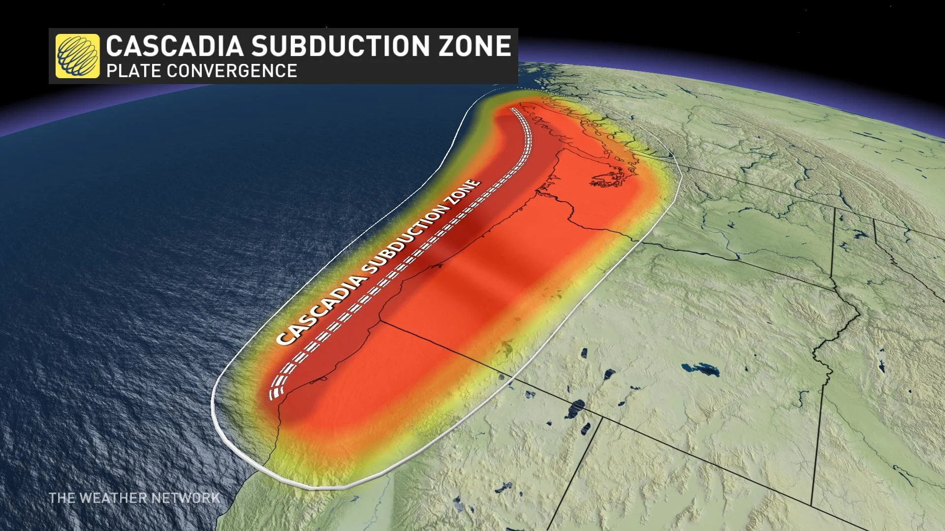
Earthquakes
Expected direct losses from a large earthquake could be as high as $75 billion
The risks from earthquakes are increasing due to population growth and rising number of people and property density in urban areas, as well as a growing reliance on infrastructure systems
The national risk profile identified gaps in Canada's earthquake resilience including seismic retrofit programs to make existing buildings stronger and more resistant; access to public information; the number of Canadians underinsured or uninsured for earthquake damages; and challenges in the emergency management system and limited access to services in remote, isolated and Indigenous communities
MOST EARTHQUAKES IN BC AND ALBERTA ARE FRACKING QUAKES (FRACKQUAKES)
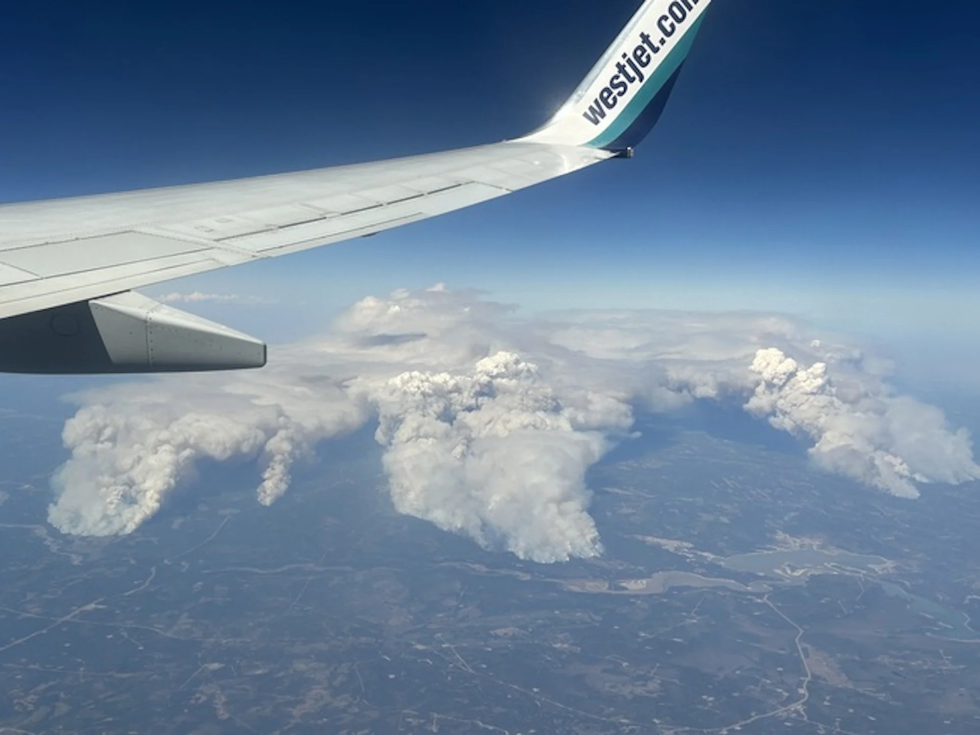
Wildland fires
The area burned annually by wildland fires has more than doubled since the 1970s. It is predicted that, by 2100, the area burned could double again
The risk of wildland fires will likely increase over time because climate change is creating longer and more intense fire seasons
Current trends point to more people and infrastructure in harm's way in the event of a wildland fire
The report identified the following gaps in Canada's wildland fire resilience including low public awareness and preventive action to protect homes, properties, and neighbourhoods; gaps in scientific knowledge and wildland fire management tools and technologies; inclusion of Indigenous peoples and diverse Indigenous knowledge in wildland fire management and response; and structural resilience to wildland fires, especially in high-risk areas
Floods
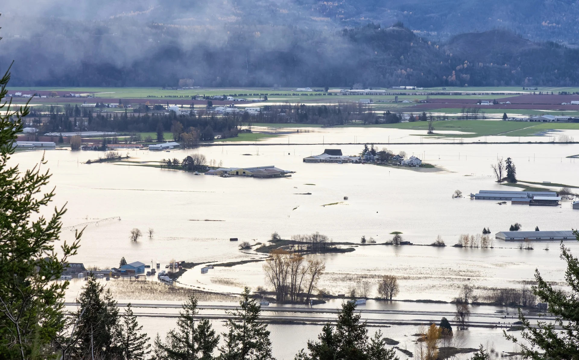
The risks from flood events will increase over time due to the impacts of climate change on weather patterns and the increasing number of people living in urban areas
The threat profile identified the following gaps in Canada's flood resilience including co-ordination among governments to manage flood risk; lack of flood risk information that impacts the management of evacuations; low awareness among Canadians of their personal flood risk; and lack of sustained investment in a national flood insurance arrangement and in countrywide infrastructure measures for prevention, like planting trees to prevent erosion
(Jaclyn Whittal/The Weather Network)
The next component to the national risk profile will focus on heat events, hurricanes and space weather. The federal government stated these three hazards were selected given their high impacts on public health, critical infrastructure, the economy, and ecosystems. The full report can be viewed here.
Thumbnail courtesy of Getty Images-1356603199.
Firefighters in east Canada battle ‘unprecedented’ blazes
By AFP Published May 31, 2023 Firefighters with Halifax Regional Fire and Emergency work to put out fires in the Tantallon area of Nova Scotia - Copyright Nova Scotia Government/AFP Handout
Firefighters on Wednesday faced a grueling uphill battle against wildfires in Canada’s Nova Scotia province, including one threatening suburbs of Halifax.
Federal help was coming, officials said, along with firefighters from the United States.
“We’re in a crisis in the province and we want and we need and we will take all the support we can get,” Nova Scotia Premier Tim Houston told a news conference. “These fires are unprecedented.”
Already, additional kit have been shipped in from Ontario, and a dozen water bombers from neighboring regions and the Coast Guard joined efforts to douse the flames and assist with evacuations.
Houston said he has also asked for the military to help out.
Prime Minister Justin Trudeau called the wildfires “heartbreaking,” and vowed unlimited support.
As of Wednesday, 14 wildfires were burning in Nova Scotia, including three out of control. They’ve so far destroyed or damaged more than 200 homes and other structures including a wooden bridge, but no injuries have been reported.
One couple described to public broadcaster CBC having lost both their home and their childcare business. “That’s my life,” a tearful Terri Kottwitz said.
Others said they saw trees on fire in their backyard as they fled with just a moment’s notice.
Evacuee Janis Churchill-Moher told CBC that she didn’t know if her home in the picturesque rural south of the province was still standing.
“Our neighbors have working farms and they just had to pack up their kids, pack up as many animals as fast as they could and run,” she said.
More than 2,000 residents of the area were ordered to evacuate earlier in the week as fires swept through the area.
“It’s a devastating situation for everybody,” she said. – ‘Frustrated and frightened’ –
Smoke from the wildfires blew down the Atlantic coast, prompting air quality alerts for the US state of New Jersey and parts of Pennsylvania, including the Philadelphia area.
David Meldrum of the Halifax Regional Fire and Emergency, pointing to record-high temperatures forecast this week, warned of “a prolonged operation” to bring under control a large fire northwest of the port city that has displaced more than 16,000 residents.
“People are understandably tired, frustrated and frightened,” said Halifax Mayor Mike Savage, adding that “some have no home to return to.”
Houston announced a ban on all activities in Nova Scotia forests, including hiking, camping, fishing, hunting, the use of off-road vehicles and logging.
“For God’s sake, stop burning. Stop flicking cigarette butts out of the car window. Just stop it. Our resources are stretched incredibly thin right now fighting existing fires,” he pleaded after several illegal burns were reported by conservation officers.
Government data shows a decline in the number of wildfires in Canada since the 1980s, likely due to improved fire prevention.
But the past decade also saw more disastrous wildfires scorching a lot more land and displacing many more people — problems set to worsen with climate change.
In recent years western Canada has been hit repeatedly by extreme weather, including floods and mudslides, forest fires that destroyed an entire town, and record-high summer temperatures that killed more than 500 people in 2021.
On Tuesday, 800 residents of Fort Chiepwyan in northern Alberta had to be airlifted to safety as fires beared down on the remote hamlet.
Earlier this month, wildfires in Alberta burned nearly one million hectares of forests and grasslands, and at one point displaced 30,000 people.
Nearly 200 structures damaged in Halifax-area wildfire
Westwood Hills, Tantallon update: The wildfire, estimated to cover 788.3 hectares, is out of control. Firefighters on scene include 170 from the HRM, 32 DNRR staff, 3 helicopters and 1 waterbomber from Newfoundland and Labrador. Source - Nova Scotia Natural Resources and Renewables
Early estimates are that about 200 structures have been damaged in the wildfire in the Upper Tantallon, N.S., area.
CBC News is reporting today that most of the damaged or destroyed structures are single-family homes. Halifax Fire Deputy Chief David Meldrum asked for patience from some 16,400 residents who are anxiously awaiting information about their properties.
He added that fire officials working on compiling information and creating a geographic map with the precise locations of every damaged property, but it will take some time.
Officials are reminding people not to try and return to their homes.
The fire was first reported on Sunday around 3:30 p.m. in the Westwood Hills subdivision off Hammonds Plains Road. The cause of that fire is under investigation, though it is likely that human activity played a role, according to Scott Tingley, the DNR’s manager of forest protection,
“It’s safe to say they have all been human-caused, we haven’t had reports of lightning in the area, so it’s human activity that’s causing them,” Tingley said.
Progress made on out-of-control wildfire
David Steeves of the Nova Scotia Department of Natural Resources said while some progress has been made in fighting the out-of-control wildfire outside Halifax overnight, a change in the weather today is expected to pose a “dangerous” challenge for firefighters.
Steeves said that southwest winds are expected to pick up during the afternoon, and the sun is expected to heat up.
“We are hopeful that we can make some gain today, but we’ll have to wait and see how the environment is going to work with us on that,” Steeves said during a press conference at the incident command center in the community of Tantallon.
“There’s going to be an increasingly dangerous situation for the firefighters that are on the ground. Safety is going to be paramount in all our tactical decisions.”
In an update from Nova Scotia Natural Resources and Renewables, the wildfire, estimated at 788 hectares (1,947 acres), remains out of control at 10:51 a.m. ET. Winds are expected to gust up to 30 kph (19 mph) throughout today, May 30, so fire may spread further this afternoon
‘Wilderness Urban Interface’ wildfires are on the rise across North America
By Karen Graham Published May 30, 2023 The Simi Valley Fire in Southern California was a devastating 2003 wildfire that burned 108,204 acres. and destroyed 37 residences and 278 outbuildings. Credit - U.S. Air Force photo by Senior Master Sgt. Dennis W. Goff, Public Domain
Wildfires that put homes at risk are growing larger and more frequent as people move into transitional zones.
CTV News Canada is reporting on the severe consequences created as the number of wildfires crashing into communities continues to grow.
They cite the 2011 Slave Lake, Alberta wildfire that – despite suppression measures – pushed past fire barriers and destroyed several hundred homes and other buildings. The wildfire burned 4,700 hectares (12,000 acres) and ended up costing $750 million.
Close to one-third of Slave Lake, a community of 7,000 people, was destroyed, with 374 properties destroyed and 52 damaged in the town, and another 59 destroyed and 32 damaged in the surrounding Municipal District.
“I think that was the most shocking time of my entire career and maybe of my life, where you’re so sure that something’s going to work, and then it doesn’t with crushing consequences,” said Jamie Coutts, the former Slave Lake fire chief.
A firefighter for more than 30 years, Coutts said wildfires have been burning “hotter, faster (and) crazier” over the last decade, and “every single person that lives in the forest is on a collision course with something disastrous happening.”
The wildland-urban interface (WUI)
Research suggests that so-called Wildland-Urban Interface wildfires, which occur where forests and flames meet human development, are on the rise. This area is sometimes called a transitional zone. Keep in mind that on Sunday, a WUI fire crashed into Halifax, destroying or damaging dozens of homes in the west of the city.
As the risk of forest fire increases, so does the risk to urban peripheries in Canada that come into contact with wild or forested areas. Following are just two devastating examples:
In 2016, a wildfire forced 80,000 people in Fort McMurray and other parts of northern Alberta to evacuate, destroyed more than 2400 buildings, and caused an estimated $3.8 billion in damage.
2016 Fort McMurray wildfire. Large flames and heavy smoke surround congested Highway 63 South.
Credit – DarrenRD, CC SA 4.0.
In 2018, British Columbia experienced its worst fire season on record forcing 3,200 people to evacuate, and close to another 22,000 to be on alert.
In the United States, which has a much larger population than its neighbor to the north, over 60,000 communities are situated where they are at risk for WUI wildfires.
And between 2002 and 2016, an average of over 3,000 structures per year were lost to WUI wildfires in the United States. In the meantime, people continue to move to parts of the country more likely to burn, raising the odds of catastrophe.
Nowhere is this dynamic more visible than in California, where eight of the largest blazes on record have struck in the past five years. The state now has roughly 5.1 million homes in what’s known as the “wildland-urban interface.”
The rapid growth of housing in flammable areas is a key reason wildfires have become more destructive over time. Not only are the homes themselves more likely to burn, but when more people live near forests and grasslands, there’s also a greater chance that fires will start in the first place.
Monday, December 20, 2021
FRACKQUAKES
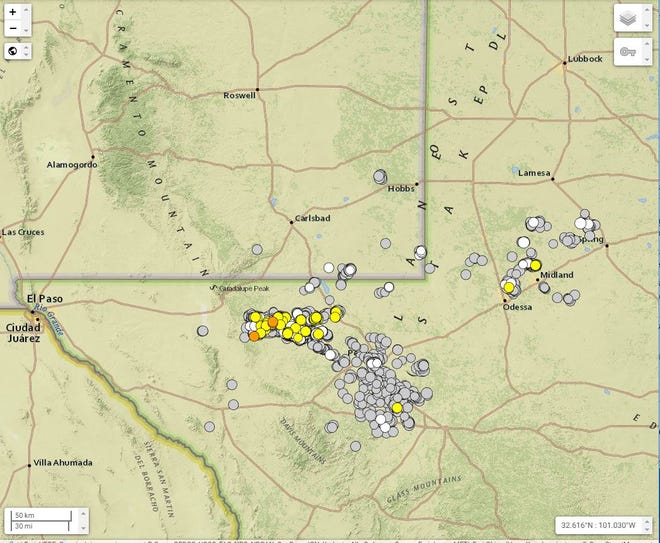
Risk of earthquakes caused by oil and gas operations in New Mexico rising
Multiple magnitude (M) 4 or 5 quakes were felt in the Midland area, leading the Texas Railroad Commission to declare a seismic response area (SRA) earlier this fall in the Gardendale region, calling for reductions in water disposal injection volumes.
Earthquakes at M 4 are generally felt but are known to cause minor damage. When recorded at M 5 or above, they may cause increasingly severe damage to structures and risk public safety.
Quakes below M 2.5 are not typically felt on the surface.
Injections rates for existing disposal wells - where water created as a byproduct of oil and gas drilling is disposed of by pumping it underground - were reduced to 10,000 barrels per day, while operators were required to report daily injection volumes and pressures to the Commission each month.
Wells permitted but not in service would not be allowed to begin injection, and the Railroad Commission said it would not issue any new permits in that area.
Then, in October the Railroad Commission announced it was creating a second seismic response area in northern Culberson and Reeves counties, just along the border with southeast New Mexico.
The Gardendale area is about a two hour drive to New Mexico cities like Carlsbad and Hobbs, but the recent SRA was closer and was more likely to impact operators in New Mexico.
In its announcement of the Culberson and Reeves counties SRA, the Railroad Commission pointed to 15 M 4 or greater earthquakes along the state line since Jan. 1, 2020, with six of those reported between Sept. 3 and Oct. 3, 2021.
That meant almost half of the heightened seismic activity in the area since last year occurred in the last month.
The Railroad Commission referred to this as an “unprecedented” level of activity. The latest SRA called for coordinated action in reducing disposal volumes and thus seismic activity. The Commission included with its announcement a list of 89 disposal wells in the area and proposed reductions in volumes.
The list included industry leaders like Chevron U.S.A. and Cimarex Energy, calling for injections to be reduced by more than half in some cases from the permitted amount.
In one case, a well owned by Chevron was asked to observe a maximum of 30,000 barrels per day (bbl/d), despite being permitted for 100,000 bbl/d.
The Commission said if its recommendations were not successful in reducing seismicity, it was prepared to act as it did in Gardendale and require that companies reduce their volumes of water injection.
Success to the commission, per the announcement, meant no more M 3.5 earthquakes in the next 18 months.
“Staff will use available public data and trends (for example, earthquake count, earthquake magnitude, and disposal volume) to evaluate the efficacy of a response plan,” read the announcement.
“Absent a coordinated industry response, RRC staff is prepared to implement its own seismic response action plan (SRAP) for the NCR SRA after 90 days.”
Michael Hightower, director of the New Mexico Produced Water Research Consortium at New Mexico State University – a project established in 2019 by the State to study and attempt to implement alternate uses of produced water beyond the oil and gas industry – said it was clear Texas’ earthquake problem was spreading toward New Mexico.
“We know there’s a lot of water coming over from Texas,” he said. “If you inject all that, you’re going to have seismicity problems. We’ve been following the seismicity. Most of the seismicity being observed is due to saltwater disposal wells. They seem to be at the depths saltwater disposal is at. People think they’re coming from over-pressurization.
“It’s getting closer and closer to us. Absolutely.”
The Consortium worked closely with Texas regulators, Hightower said, aiming to devise technology that could treat produced water and recycle it for uses like agriculture or even drinking water – harnessing a new, plentiful source of water in the arid region.
Many oil and gas companies already recycle produced water for subsequent fracking operations, but Hightower said expanding the potential for its reuse presented an economic opportunity and a way to address environmental and water scarcity concerns tied to fossil fuels.
“The big issue is how do you reduce the volume of produced water you’re disposing of. That is the exact mission of the consortium,” he said. “There are a lot of companies trying to look at reducing the volume they dispose of.”
The State, through the consortium – made up of scientists, state agencies and energy companies – was targeting a goal of a 30 to 60 percent reduction in produced water disposal, Hightower said.
He said the economics could also make sense to the private sector, as the price of injection continued to climb in recent years, and companies hoped to reduce their environmental impacts in response to investor concerns.
“A lot of companies are looking at reusing that produced water and putting it to beneficial use,” Hightower said. “Generally, industry understands it’s probably the over-pressurization from saltwater disposal wells. They need to start addressing it. Treatment and reuse is one of those options.
“What we’re hoping we can do for the Permian Basin is work with counties on both sides of the border so we can come up with strategies in the future.”
Jason Jennaro, chief executive officer at Breakwater Midstream, a company specializing in transporting produced water, treating it and redelivering the cleaner water back to the oilfield, said the recent seismic activity made finding alternatives to disposal injection increasingly urgent.
The growing trend in seismicity meant big business for Jennaro and Breakwater. The company recently announced its second commercial-scale water recycling facility, meaning it can aggregate waters from multiple companies in the Midland Basin with a capacity of about 200,000 barrels per day.
The Morita Commercial Recycling Facility will enter Breakwater's network of pipelines intended to transport produced water away from seismically active areas in the oilfield for treatment, and then back out to well sites for reuse.
Together with Breakwater's other commercial-scale facility, the 360,000-barrel Big Spring Recycling System, the company estimated it could treat and distribute more than half a million barrels of produced water a day for the Midland Basin.
"Operators are looking for environmentally sustainable alternatives to disposal within these SRAs and seismic clusters, which is why system interconnectivity and commercial recycling is central to sensible stewardship of the water," Jennaro said.
Regulatory action from the Commission, he said, will severely impact operations and force the industry to seek alternatives.
“It impacts what people can do operationally,” Jennaro said. “That’s why operators are very concerned about this. They know when an SRA is declared on top of them, it has the potential to materially impair the value of their leasehold.”
Another harbinger of the growing problem, Jennaro said, was also the proliferation of smaller earthquakes, often not felt on the surface but indicative of increased activity.
He said this activity began to increase in 2017, when oil and gas boomed in the region, up to about three per day recently.
In 2021, records show the region was on track for more than 1,200 earthquakes between M 1 and M 4.
“We’re getting thousands of earthquakes per year. We just didn’t see anything like this in the past. It’s a call for environmental stewardship and for folks to be better managers of our water resource,” Jennaro said. “That calls for not relying on disposal in areas of high seismicity and recycling more water.”
The more induced seismicity in Texas, Jennaro said, the more regulators were likely to seek curbing injection volumes.
That could mean sending more water over the border to New Mexico to avoid Texas’ increased regulatory action and continue pumping water underground.
“When disposal is limited on one side of the border, it will have the impact of pushing water in Texas back up to New Mexico and impacting disposal there,” Jennaro said. “It will impact the hydrodynamics of water flow all around the SRA.”
Adrienne Sandoval, director of New Mexico’s Oil Conservation Division (OCD), the State’s main oil and gas regulator, said her agency is encouraging operators recycle and reuse water instead of injecting.
To avoid over-pressurization, Sandoval said the OCD implemented well-spacing requirements as a condition of permitted disposal wells.
While New Mexico has yet to see the seismic activity observed and acted upon in Texas, Sandoval said the State is closely watching what’s happening over the border, collecting data, and hoping to be proactive to prevent the problem from forcing its regulatory hand.
“We have seen some induced seismicity on the New Mexico side. It’s sort of along the Texas line and along the Lea and Eddy county line. We’re working with operators to gather data,” she said. “We want to ensure we’re being protective and managing things in proactive way so we can minimize seismic activity as much as we can.”


