By Allison Finch, AccuWeather, Accuweather.com

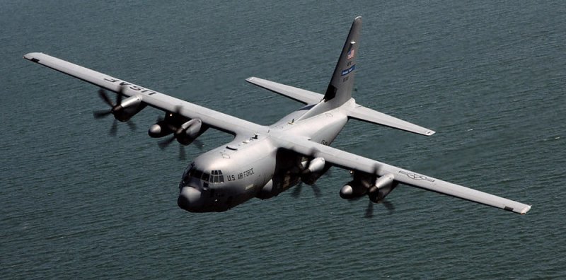
This undated U.S. Air force photo shows a WC-130J Hercules from the 53rd Weather Reconnaissance Squadron "Hurricane Hunters" as it flies the first mission of the 2008 hurricane season.
File Photo by James B. Pritchett/U.S. Air Force | License Photo
Hard-core scientists aboard specially equipped National Oceanic and Atmospheric Administration aircraft play an integral role in hurricane forecasting.
Data collected from these high-flying and high-tech meteorological stations in the midst of a storm help forecasters make more accurate predictions during a powerful hurricane while researchers gain a better understanding of how storms evolve, which improves forecast models.
But the job is not for the faint of heart.
In an interview with AccuWeather national reporter Jillian Angeline, NOAA Flight Director Quinn Kalen described how these "hurricane hunters" take on these daring missions flying into such fierce storms.
Once positioned correctly above a hurricane, at an altitude of about 45,000 feet, a scientist releases a dropsonde, a weather device specially designed to be dropped out of an aircraft. As the dropsonde is falling through the hurricane, it collects data from the surrounding atmosphere, such as temperature, humidity and wind direction and velocity, which is then sent back to the aircraft via radio transmission.
"We're getting an entire column of data," Kalen explained. "It takes about 15 to 20 minutes for that dropsonde to fall. So that's a lot of data. The [dropsonde] is getting data every quarter of a second."

One of many dropsondes that are released into a hurricane to gather data.
Research flights last 8.5 hours, and roughly 30 dropsondes are released during that time, gathering approximately 504,000 data points per flight, according to University Corporation for Atmospheric Research.
All of these data points are collected and transmitted back to the mainland, where scientists import them to forecast models.
On top of the data collected by the dropsondes, the plane, which is named after the Muppet character Gonzo, is outfitted with weather radar that collects even more data.
"The shape of the nose radar is why we call this Gonzo," Kalen said. "It's kind of a weird nose. Gonzo has that weird nose."
The information collected around and above the hurricane from the radars on either end of the plane help scientists create a detailed picture of the atmosphere surrounding the hurricane. Specifically, the tail Doppler radar, located on the back of the plane, collects radar images of the convection within a hurricane as the plane flies.
Kalen noted that the view from the plane right above the hurricane resembles fog. Not much can be seen from the plane's window until it is away from the storm.

Quinn Kalen, NOAA flight director, talks about his role as a hurricane hunter.
"It's essentially like you're flying in fog," Kalen said. "We'll get a real good view of the hurricane, not when we're in it but when we're out of it."
National Hurricane Center Director Ken Graham told AccuWeather the extremely valuable information hurricane hunters gather has improved the accuracy of hurricane models by 10-15 and has improved the hurricane intensity forecast by 20.
"They're heroes going towards the storm and it's bumpy. But they give us the data that we need," Graham said about the scientists that fly into hurricanes.
The role does come with plenty of risks. Kalen said scientists must always have an exit plan in case it gets too dangerous.
"It's definitely an extreme profession. Definitely like, it's the intensity of it. The intensity of the storm, of course, but the dependency on your job to do well is high," Kalen said, adding that flight directors like himself serve as a "liaison" between the pilots and scientists.
The data collected from these flights will be important in the incoming months as AccuWeather meteorologists predict another busy hurricane season this year, with six to eight hurricanes -- three to five of which are forecast to reach major hurricane status.
No comments:
Post a Comment