One Australian Research Vessel is Racking Up a String of Wreck Finds

[By Toni Moate and Emily Jateff]
On August 23 1969, the coastal freighter MV Noongah departed Newcastle bound for Townsville with a cargo of steel and 26 crew. The 71-meter ship had been a regular sight along the eastern seaboard for a decade as it hauled cargo between cities up and down the coast.
Two days later, the vessel disappeared in the night beneath ten-metre waves, lashed by a violent storm. Tragically, only five of the 26 crew would be rescued during one of the largest searches for survivors in post-war Australian maritime history. As for the MV Noongah, its resting place would remain a mystery.
Until now.
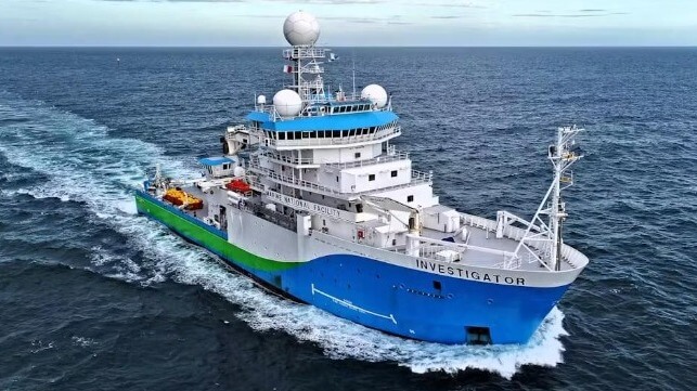
While on a research voyage to study submarine canyons off the New South Wales coast, a team aboard the CSIRO research vessel RV Investigator became the first to set eyes on MV Noongah in nearly 55 years. This discovery was no accident. It was part of a collaborative project and a targeted investigation to help identify a mysterious shipwreck.
It’s also no coincidence there have been several shipwreck discoveries in the news recently. Australia’s national science ship has developed an impressive record as a shipwreck sleuth.
What is RV Investigator?
RV Investigator is part of the Marine National Facility – a national research infrastructure operated by CSIRO, Australia’s national science agency.
All Australian researchers and their international collaborators can access the capabilities of RV Investigator. This makes it a collaboration hub for marine research. And it’s been an important factor in many of the recent shipwreck discoveries.
Over the past ten years of operation, more than 150 institutions have collaborated to deliver science on voyages. Usefully, RV Investigator can accommodate multiple projects on each voyage. The research has ranged from fisheries’ surveys and seafloor mapping to atmospheric studies and, of course, maritime heritage surveys.
RV Investigator is equipped with a suite of advanced acoustic systems. It also has three seafloor mapping systems, called multibeam echosounders. These allow for high-resolution measurements (bathymetry, literally meaning “deep measurement”) of the seafloor, from shallow coasts to full ocean depth.
These systems map the seafloor everywhere the vessel goes, both through data collection while underway, and through targeted surveys.
Both the distance RV Investigator travels during its annual research program and the volume of bathymetric data it collects are immense. This greatly increases the likelihood of making seafloor discoveries.
Over the past ten years, RV Investigator has travelled more than 500,000 kilometers and mapped more than 3 million square kilometers of Australia’s marine estate. It has circumnavigated the continent several times.
All this has provided an opportunity to investigate many suspected shipwreck sites. These are often “piggyback” projects – ones that are added to the voyage but use no additional resources.
The power of collaboration
Shipwreck discoveries are impossible without collaboration. The maritime community, heritage agencies, research agencies and members of the public have all contributed to the recent shipwreck finds.
It is not uncommon for searches to be targeted by local knowledge from fishing communities, volunteer shipwreck hunters and even historians who have pieced together clues on the potential location of shipwrecks.
Outreach to those affected by the findings is also invaluable. This includes the survivors of these tragedies and the families of those lost at sea, to keep them informed throughout the process.
Shipwreck discoveries can literally change lives – like the reunion of two siblings who spent their lives apart as orphans after their father died onboard SS Iron Crown in 1942.
‘Eyes’ in the depths
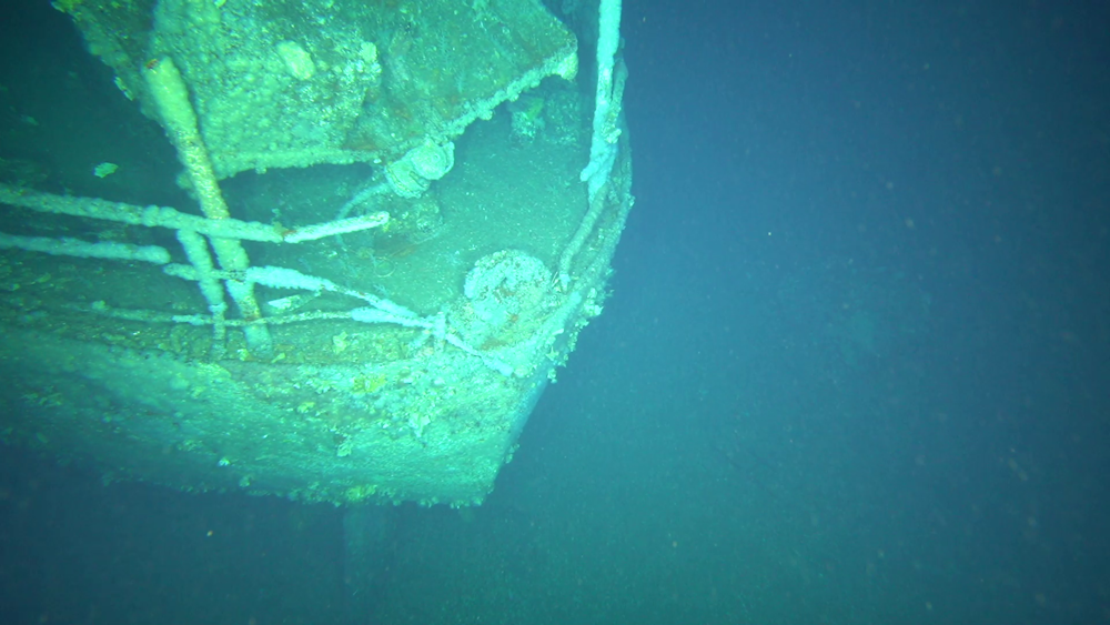
RV Investigator also has specialized drop cameras that can provide a view of the seafloor at depths up to 5,000 meters. The visuals provided by these have been essential for identifying shipwrecks once found.
In 2023, a CSIRO team used this camera system to help identify the wreck of SS Nemesis, a steamship that was lost in 1904 off the coast of New South Wales. Also in 2023, an unidentified wreck off the southwest coast of Tasmania gained a name – it was the coastal freighter MV Blythe Star which capsized and sank in 1973.
The large areas of seafloor mapped by RV Investigator have also led to unexpected discoveries. The wreck of the 1890s iron barque Carlisle in Bass Strait in 2017 was a “chance encounter” for the vessel.

A view of the stern of MV Blythe Star. CSIRO
Why hunt for shipwrecks?
These discoveries are important for several reasons. Finding and analyzing a shipwreck can help us understand the circumstances that led to these tragedies. It can also help provide closure to affected communities whose loved ones were lost at sea.
Knowing the current state of the shipwreck is important for heritage professionals and agencies who manage and protect the sites. Some shipwrecks are at risk of creating environmental damage such as fuel or oil leaks, so having data on them is vital for managing those risks.
RV Investigator is currently scheduled for a series of scientific upgrades, including its acoustic systems. With 8,000 shipwrecks scattered around Australia’s coastline, and more than half of those undiscovered, there are many more maritime mysteries to solve.
Toni Moate is Chair of the National Marine Science Committee and Director of CSIRO National Collections and Marine Infrastructure.
Emily Jateff is an adjunct lecturer in archaeology at Flinders University.
This article appears courtesy of The Conversation and may be found in its original form here.

The opinions expressed herein are the author's and not necessarily those of The Maritime Executive.
No comments:
Post a Comment