Europe Is Burning: The Deadly Heatwave That Exposes the Criminality of Fossil Capitalism and the Economy of Genocide
July 3, 2026
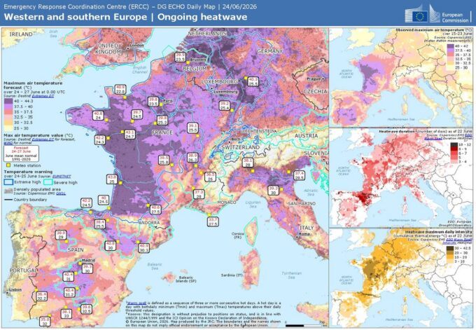
Conditions on 26 June 2026 as per ERCC – CC BY 4.0
Europe is on fire. Record-shattering heat waves have gripped the continent, pushing temperatures above 40°C (104°F) in multiple countries, buckling infrastructure, overwhelming hospitals, and claiming thousands of lives. This is not a natural disaster. It is the foreseeable, profitable outcome of decades of fossil fuel addiction and capitalist extraction.
According to a sobering analysis by The Economist, the late-June heat spike could cause around 12,000 excess deaths across Europe. The study, covering 854 cities, shows that human-caused climate change has made the event far more lethal than it would have been otherwise. France alone has already reported over 1,000 excess deaths, with Spain, Italy, and Germany also suffering heavy tolls, and northern countries — that are often less prepared for the heat — facing temps well over 30°C degrees. The elderly and the poor are paying the highest price. The World Health Organization has confirmed more than 1,300 excess deaths linked to the heat since June 21.
The oceans tell an even darker story. In June 2026, global sea surface temperatures reached a new all-time record, hitting averages of 21.0°C according to the EU’s Copernicus Marine Service — surpassing previous records set in 2023 and 2024. Scientists warn we are entering “uncharted territory,” with marine heat waves expanding and intensifying. A supercharged El Niño has thrown more fuel on an already burning planet, but the root cause is clear: decades of unchecked carbon emissions by the fossil fuel industry.
This is not misfortune. This is mass murder by profit.
The fossil fuel giants — ExxonMobil, Shell, BP, Chevron, Italy’s ENI — have known for half a century that their products were cooking the planet. They lied, they lobbied, they delayed, and they continued drilling, fracking, and expanding. In 2025 alone, ENI reported adjusted net profits of around €5 billion, while European oil majors collectively posted obscene windfall gains. Greenpeace and other reports have repeatedly exposed how these companies continue to prioritize extraction over survival, even as they greenwash their images with token “transition” investments that amount to a fraction of their fossil fuel spending.
ENI has been deeply entangled in energy deals tied to Israel’s operations in occupied Palestinian waters, supplying crude oil that powers the military apparatus carrying out what many legal experts describe as genocidal actions in Gaza. Fossil capital doesn’t just warm the planet — it fuels the wars and occupations that accelerate ecological collapse.
Nowhere is this more obscene than in the fusion of war and ecological destruction. The world’s militaries — led by the United States and its allies — are among the largest institutional emitters on Earth. The ongoing genocides in Gaza and the Sudan, and wars in Ukraine, Iran and elsewhere pour tens of millions of tons of CO₂ into the atmosphere through fuel-guzzling jets, tanks, bombs, and reconstruction. Every missile fired, every drone launched, every city reduced to rubble accelerates the very climate breakdown that makes these heat waves deadlier. War is not separate from the climate crisis — it is one of its most vicious engines.
The new priests of the digital age — the hyperscale data centers powering Artificial Intelligence — are adding massive new heat to an already overheating planet. Data centers consumed about 415 TWh globally in 2024, roughly 1.5% of world electricity, and are projected to nearly double by 2030. In Europe, demand is exploding. A single large AI training facility can consume as much power as 100,000 households, while the heat they generate raises local land surface temperatures by an average of 2°C, with some areas seeing spikes as high as 9°C. The AI boom is not “clean tech” — it is another ravenous consumer of fossil energy in a system that cannot stop growing.
Even more terrifying is the human body’s hard limit. Scientists define a wet-bulb temperature of 35°C (95°F) as the theoretical survivability threshold — the point at which, even in shade with unlimited water, the human body can no longer cool itself through sweating. Recent studies show that deadly heat stress is already occurring at lower wet-bulb levels, especially for the elderly and those with pre-existing conditions. During this heatwave, large parts of southern Europe approached or breached dangerous thresholds, where mortality spikes dramatically. We are not just losing comfort. We are losing the basic environmental conditions required for human survival.
Skeptics still trot out tired arguments: “It’s just natural cycles,” “The models are wrong,” or “Alarmists like Guy McPherson have been predicting doom for years.” McPherson, the controversial ecologist who has long warned of near-term human extinction, continues to argue that we are witnessing abrupt, irreversible collapse driven by feedback loops — Arctic methane release, permafrost thaw, and accelerating warming. While his exact timeline remains debated, the underlying science he cites — runaway warming and tipping points — is increasingly validated by mainstream observations. The deniers’ real record is one of consistent failure: every prediction of “cooling” or “stabilization” has been falsified by relentless temperature records, melting ice, and rising seas. Their skepticism is not science — it is ideological defense of a dying profit model.
Europe likes to call itself a climate leader. In reality, it remains dangerously unprepared. Most cities lack proper cooling infrastructure. Heat action plans are inadequate. Vulnerable populations are abandoned to suffer and die while governments prioritize corporate profits and military budgets over human survival.
The message of this heat wave is brutally simple: we are no longer approaching the abyss. We are in free fall. Every additional fraction of a degree means more corpses, more suffering, and more irreversible damage to the only home we have.
The time for half-measures and greenwashed promises is long past over. We need a ruthless, immediate dismantling of the fossil fuel economy, an end to the wars that feed it, and a radical reorientation toward genuine justice — for people and for the planet.
The heat is not coming. It is here. And even with the dismantling of the criminal system driving it, it is only likely to get worse — until it becomes unsurvivable. Strategies exist that could help provide some temporary relief if the world collaborated and cooperated to implement them. The struggle for human existence has begun. The question is whether we will fight with the urgency this moment demands to prioritize our common humanity and our planet above allowing business as usual to steam ahead.
Michael Leonardi lives in Italy and can be reached at michaeleleonardi@gmail.com
The Mad Scramble to Dim Sunlight

Image by Johannes Plenio.
Whew! it’s hot out there, and the more the planet heats up, the more geoengineering appeals to billionaire types willing to bankroll projects to reflect sunlight to outer space.
But solar radiation management (SRM) is a touchy subject that’s yet to make an impact on global warming. Who knows, maybe it never will… meaning, not in enough time. Alas, the unexpected rapid rate of global warming has shortened the time frame that’s available to do something constructive. And SRM, like a dangling participle, needs a lot of work.
The harsh reality of today’s climate change has snuffed out years of theatrics by climate advocates failing to convince world governments and the public of how real and dangerous it really is as a threat to life on Earth. Nowadays, global heat itself is proving climate change is a real threat to life. This is a new phenomenon that’s never happened before to this extent throughout all of human history.
How can anybody fail to recognize global heat setting new records year-by-year for 11-12-straight years? That is according to the World Meteorological Organization. Europe certainly recognizes it; people die in botched attempts to escape heat. The extreme heat makes the nightly headlines with EU roads buckling, trains suspended, tracks bending, schools closing, nuclear plant shutdowns, power cables breaking. This is climate change challenging economic infrastructure. It’s likely to get worse.
This is not normal.
Don’t fall for climate deniers in the U.S. that cook-up stupid stories to diminish the threat of climate change, e.g., “more people die from winter cold than from summer heat” recently stated by a senior administration official. Oh please!
Meanwhile, there’s an element in society, known as technocrats, that boldly, hubristically believe human ingenuity via geoengineering will challenge and defeat climate change before it defeats them. They’re probably wrong.
MIT on Geoengineering
MIT recently weighed in on the subject: Geoengineering Faces Major Practical Challenges, MIT d/d June 18, 2026. Subtitled: “There’s a lot to figure out about the controversial climate tech.”
For example: “Solar geoengineering is often portrayed as a sort of emergency brake. Something along the lines of ‘Pull in Case of Climate Emergency’ to scatter light-reflecting particles to bounce sunlight out of the atmosphere and cool the planet… But it might be less like a simple brake and more like a complicated, entirely unsolved puzzle,” Ibid.
Accordingly, attempting to alter the climate to save our collective butts from horrific global heat might be a lot harder than anybody realizes. And according to the study underlying the MIT article, “to actually actively cool the planet in a significant way, and to make sure we understand exactly what effect we’re having, there’s a lot that researchers still need to learn… There are major concerns about what effects might come from large-scale attempts to cool the planet. The effects could be positive for some parts of the globe and negative for others.”
The impact of our rapidly changing climate that’s directly influenced by too much fossil fuel CO2 spewing into the atmosphere is found on the nightly news. Cars tumble down flooding city streets and black ash from Canada’s biblical wildfires have sprinkled across America’s Great Lakes in the recent past, a casualty of global warming drying out the boreal forest and dangerously destroying a powerful carbon sink. During 2025-26 record-setting fires hit Florida, California, Georgia, Oklahoma, and Nebraska all shattering historic records for burned acreage and unheard-of insurance losses.
None of this is normal.
Major insurance companies have been regularly speaking out about extreme climate change as a risk to the functioning capitalistic system. Some have gone so far as to express outright destruction risks, see: Climate Crisis on Track to Destroy Capitalism, Warns Top Insurer.
Meanwhile, behind the scenes, in private, geoengineering of the planet’s atmosphere increasingly catches the attention of billionaire money. All of which brings to surface an upcoming controversial issue that’s certain to turn heads. In fact, geoengineering has quietly but assuredly drawn fierce battle lines for years. It brings out the brightest and the best in academia as well as the lowest of conspirators into a clashing of interests with sparks flying.
The Chemtrail Conspiracy Theory has a long history of claiming airplane contrails have been releasing solar radiation management chemical agents for purposes of weather modification or some other purpose. This has been met by strong pushback by federal agencies and the scientific community, finding no signs of legitimate evidence. Interestingly, ex-CIA employee and famous whistleblower Edward Snowden, who had no axe to grind at the time, in a Joe Rogan interview said he used his “ridiculous access to the networks of the NSA, the CIA, the military, all these groups. I couldn’t find anything… no evidence of aliens or mysterious chemtrails.” Nevertheless, RFK, jr. endorsed chemtrail conspiracy theories. And there are serious students of chemtrails that maintain it is real. This remains a big ball tossed into the air that hasn’t landed yet.
Now, it’s coming to light that private entities have been taking pokes at geoengineering the atmosphere in the spirit of mitigating global heat, which has dramatically increased to a new higher level suddenly and unexpectedly. Climate scientists have addressed this new danger of a “fundamental shift” as global warming jump-shifted 10-times normal, in only one year, along with surprisingly massive and extensive ocean heat waves across almost the entire oceans lasting over 500 days, confounding scientists (see- Ocean Heat Goes Ballistic).
Ocean Heat Content (OHC) has been setting new records, every year, for nine consecutive years. This all adds up to one hell’uva scary climate onslaught with a new regime of heat in the offing. This festering problem has been identified by elite scientists, and it’s downright scary. Human activity is negatively impacting the complexion of the planet via a massive acceleration phase of extreme heat with Antarctica on edge.
Some billionaires have taken notice. A recent Politico article, Researchers Quietly Planned a Test to Dim Sunlight. They wanted to ‘Avoid Scaring’ the public d/d July 27, 2025, exposes behind the scenes activity to influence (geoengineer) the atmosphere, which sparks enormous international attention. Is it morally kosher, will a Frankenstein climate haunt civilization, will it disrupt nature more so than it helps, will it work?
The Politico article flushes out an aborted attempt a year ago on a retired aircraft carrier to test a device to create artificial clouds. Come to find out, their intentions went well beyond that initial experiment. The bigger plan involved spaying salt water to dim the sun’s rays over a stretch of ocean larger than Puerto Rico.
According to the article: “The details outlined in funding requests, emails, texts and other records obtained by POLITICO’s E&E News raise new questions about a secretive billionaire-backed initiative that oversaw last year’s brief solar geoengineering experiment on the San Francisco Bay,” Ibid.
As further stated, human tinkering with the climate has drawn political backlash as well as generating conspiracy theories all of which adds to challenges of even small-scale tests. The test referenced by the article lasted all of 20 minutes run by the University of Washington intended to last months. It was shut down by Alameda city officials that did not buy into secretive testing without prior public notice.
The university’s Marine Cloud Brightening Program has much bigger plans than the Alameda pilot test on the carrier deck in Alameda. The Program had received some federal funding and wanted to gain use of government ships and planes. The Program in concert with a geoengineering advocacy group Silver Lining and the scientific nonprofit SRI International has its eyes set on big dealings to “fill in gaps” of safety and effectiveness of the technology.
“Alameda was a steppingstone to something much larger, and there wasn’t any engagement with local communities,” said Sikina Jinnah, an environmental studies professor at the University of California in Santa Cruz. “That’s a serious misstep,” Ibid. Meanwhile, the University of Washington maintains innocence of any intention to alter the climate, rather, their only goal was to research the technology, not deploy it. Sarah Doherty, an atmospheric professor at the university said: “There are no plans for conducting large-scale studies that would alter weather or climate.”
With global warming coming of age much sooner than even most negative warnings predicted and stronger, sooner than climate scientists expected, geoengineering to deflect incoming solar radiation is assured to get much more attention, begging the ultimate question of whether humans should mess around with nature; although, greenhouse gases like CO2 have already demonstrated human interference causes too much heat. In a very real practical sense, fossil fuel emissions (CO2) have already geoengineered the climate for over 200 years, resulting in a haywire climate system characterized by unprecedented events almost every year. “Unprecedented” is fast losing its impact as a statement of alarming fact. It’s become a routine fact.
Still, the million-dollar question: If we broke it, can we fix it?
Critics of SRM are adamant and abundant, for example, Solar Geoengineering Could Wreak Havoc on the Planet, Sierra d/d September 21, 2023: “Dimming the sun to slow down global warming might buy us some time. But it would also come with significant risks. The impact would not be uniform across the globe and cause serious disruption of established weather patterns that agriculture relies upon. And a moral hazard would exist as it encourages fossil fuel polluters to ignore needed cuts in CO2 emissions. And, what if it becomes necessary to stop, to turn it off, then what? And who gets control of tampering with the global thermostat may be impossible to reconcile.”
Big question marks remain as serious obstacles to practical geo-engineering of solar radiation, anytime soon.
‘Hopeful’ Credible Solutions
For those interested in pursuing detailed information about potential practical solutions, there are some early-stage private organizations that command attention, e.g., Climate Restoration, which advocates iron-fertilization of ocean ‘eddies’ to initiate a process to absorb and rebalance CO2.
Additionally, a recent article: “Letter: Greenland Meltdown and the Reasons It Matters” in Financial Times d/d January 25, 2026 by John Nissen, Chair of the Planetary Restoration Action Group, London: “A pressing need exists to start lowering the Arctic temperature while it is still just possible using the most powerful, available cooling technique, stratospheric aerosol injection (SAI))”
The above-mentioned organizations base their solutions on historic evidence of nature’s volcanic eruptions affecting the global climate system.
As stated by The Harvard Solar Geoengineering Research Program (SGRP), solar geoengineering is not a replacement for reducing emissions or adapting to climate impacts. In other words, SRM is only one tool in a very big fixit box. It does not remove what’s already been done. Scientists say this must be done to fix things, but direct air capture (DAC) of CO2 is immature, inadequate, and laughable, like taking a peashooter to a war zone. In part, this is why polar scientists at recent scientific meetings insist CO2 emissions must stop now or Antarctica is assured of acting out.
Monitoring the Sky
It should be noted that NOAA’s Chemical Sciences Lab monitors the sky for renegade sunlight dimmers: “Every few weeks, researchers in Boulder, Colorado, release a balloon that rises 17 miles into the sky. Similar balloons are launched with less frequency from sites in Alaska, Hawaii and New Zealand; Reunion Island, near the coast of Africa; and even Antarctica. They make up the building blocks of a system that would alert American scientists to geoengineering.”
According to the Union of Concerned Scientists, as of May 21, 2026, the Trump administration has proposed a 32% cut in NOAA’s funding.
“Since September of 2024, federal science agencies in the US have axed nearly 120,000 employees, in a stinging loss for public research. Some of the heaviest impact was felt by scientists studying the climate.” (source: Futurism, June 25, 2026)
Meanwhile, global warming is not waiting around for stupid humans to figure out how to fix a problem they’ve created, but ignored, for more than a couple of centuries. After 200 years of feeding the beast, the fuse has finally been lit, and it’s burning like a house afire. For evidence, just ask any major home insurance company.
A bigger question is whether there’s enough time to organize the world to agree to attempt dimming sunlight. This hasn’t even begun to coalesce yet, but there is plenty of discord.
Robert Hunziker lives in Los Angeles and can be reached at rlhunziker@gmail.com

