Late winter is getting a little warmer – but killing freezes after a warm spell are a growing risk

As the U.S. warms, some areas of Florida that once were at risk of a spring frost no longer are.
As the U.S. warms, some areas of Florida that once were at risk of a spring frost no longer are.
March 26, 2022
By Debbie Carlson
The end of winter in the U.S. is getting more dangerous for food growers – and that could be another risk for food prices.
The changing weather patterns could significantly hurt food and agriculture businesses, such as those in the Invesco Dynamic Food & Beverage ETF PBJ, +1.01%, including ADM ADM, +3.38%, and General Mills GIS, +1.55%, and may cause crop prices to fluctuate, as tracked by Invesco DB Agriculture Fund DBA, +0.77%.
Using new information derived from its 1991–2020 U.S. Climate Normals, the National Oceanic and Atmospheric Administration updated its spring freeze map, which shows the most common date range where areas across the U.S. can expect to see temperatures dip under 32 degrees Fahrenheit for the last time before summer.
NOAA is the U.S. government’s scientific regulatory agency that forecasts weather and monitors oceanic and atmospheric conditions, and its climate normals reflect the impacts of the changing climate on day-to-date experiences. Normals are baselines to compare the current weather to what would normally be expected for the time of year. These cover 30-year periods and are updated every 10 years.
Looking at the new map versus the previous map from 1981-2010, there seems to be little change. While subtle, it’s there and it shows how climate change is warming parts of the country.
Here’s the new map:

NOAA
And here’s the previous one:
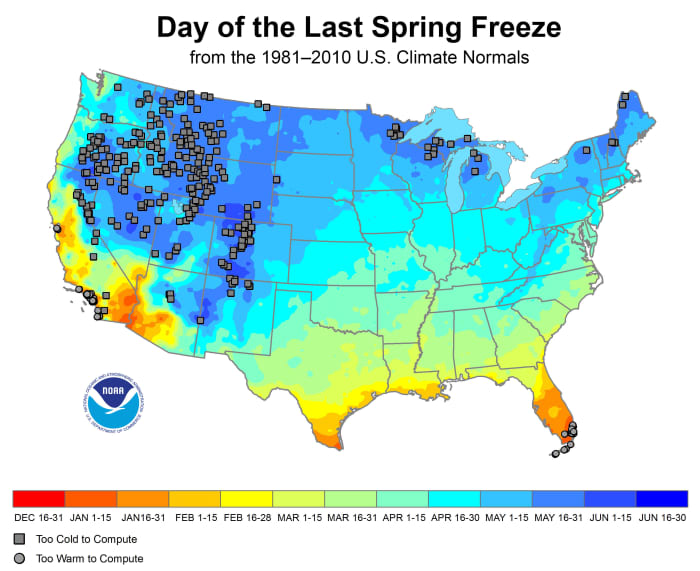
And here’s the previous one:
NOAA
Squares on the map represent areas that are susceptible to freeze any time of the year, and a close read shows there are fewer of them, especially in the Rocky Mountains, areas of northern Wisconsin, Michigan and New England, says Mike Palecki, U.S. climate normals project manager for NOAA.
Some squares disappeared because a recording station stopped, Palecki says, but overall it shows a greater trend of some areas no longer being at risk for a freeze year-round. That’s particularly noticeable in the West and in the Rocky Mountains, where the number of locations that can have a freeze year-round are only happening at even higher elevations.
On the flip side, there are more places now – look at Florida, Texas and California – that were at risk from some freeze that haven’t seen any frost no longer experience frost. That underscores how those areas are warming faster. Those places are marked with circles on the map. It also shows how as a country, the western U.S. is warming at a faster rate than the eastern U.S.
Investing Insights with Global Context
Understand how today’s global business practices, market dynamics, economic policies and more impact you with real-time news and analysis from MarketWatch.
A more troubling trend
Not visible on the map is a more troubling trend, especially for farmers and home gardeners. Palecki says the data from climate normals shows there’s more heat accumulating before the last frost date, with early springtime warmer in much of the U.S., except for small areas in the Dakotas.
Known as growing degree days, this data are used to estimate plant and insect growth during a season. With more warmth in early spring, there’s a better chance of having plants start to grow before the last frost. That leaves tender plants at risk of a late killing frost.
“The possibilities of a cold air mass coming down from Canada into Chicago have not changed very much during the course of the spring. So you can have considerable warmth in say, March and early April, but you can still have that cold air mass that brings the last frost down to your area just the same,” he says.
Palecki says this type of weather pattern has been a problem for the cherry crops in northern Michigan. Trees blossom in warm early spring temps, but frosts cause the flowers to drop and no cherries are produced. According to Michigan Climate Action Network, Michigan cherry farmers have seen serious crop losses in 2002, 2012 and 2015. Washington state, another big cherry grower, has also experienced big losses.
These maps are from NOAA; so far the U.S. Department of Agriculture, which produces zone maps for horticulture use hasn’t updated its data. But these maps are useful for home gardeners. Don’t jump the gun and plant those tender summer tomato and pepper plants after a week of warm weather in early spring.
No comments:
Post a Comment