Tuesday, March 31, 2026


BEYOND THE BOSPORUS: Turkey builds house for PKK leader Ocalan on prison island Imrali

BEYOND THE BOSPORUS: Turkey builds house for PKK leader Ocalan on prison island Imrali
An image of what Ocalan’s house on Imrali might look like as AI-generated by Gemini. / Gemini, AIFacebook
By Akin Nazli in Belgrade March 30, 2026

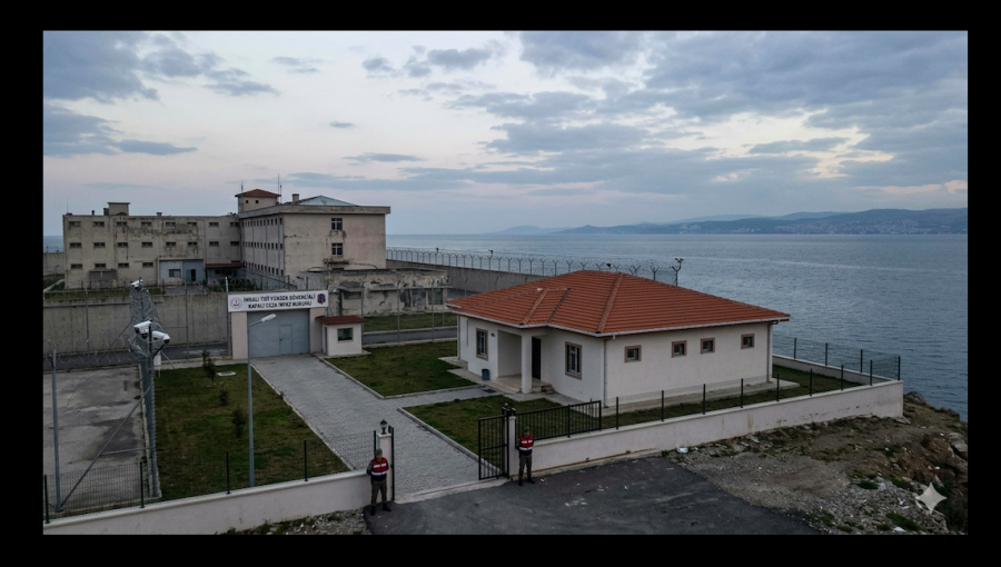
The Turkish government has built a house for Abdullah Ocalan, the leader of the militant-politico Kurdistan Workers’ Party (PKK), imprisoned for life after he was abducted by intelligence agents in Nairobi, Kenya 27 years ago.

The dwelling was constructed on Imrali prison island, in the Sea of Marmara, south of Istanbul, where Ocalan was incarcerated, Tuncer Bakirhan, co-chair of Turkey’s pro-Kurdish DEM Party, said on March 28.

Prior to the confirmation of the residence provided by Bakirhan during a televised interview on Medya Haber TV, a Belgium-based broadcaster operated by the PKK, there were rumours of the development in Turkish media.

Spit it out

“A place, a building or a house has been built for Ocalan on Imrali. Actually, there's a complex there, but what is its name, what is its status?” Bakirhan said, struggling to spit it out.

“The issue of what we will say when we go there, how we will describe it, needs to be clarified. I think there may be developments on this matter soon,” he added.

“Imrali delegation”

On March 27, three members of the DEM Party’s “Imrali delegation”, namely Pervin Buldan, Mithat Sancar and Faik Ozgur Erol met with Ocalan.

“There was a meeting lasting longer than five hours, attended by our delegation, the state delegation and Mr Ocalan,” Bakirhan also said.

“We know that this meeting focused on addressing the setbacks and discussing the steps that need to be taken for the progress of this [peace] process [with the Turkish government], which we call the second phase,” he also said.

PKK? No. “The PKK”

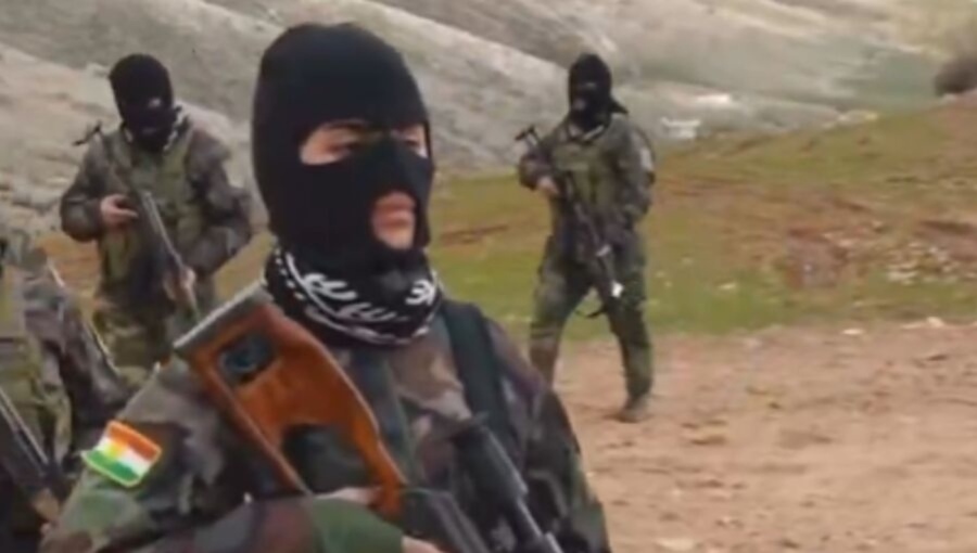
DEM, with substantial representation in the Turkish parliament, is the legal political wing of the political movement of Turkey’s Kurds, with the latter loosely referred to in general as “the PKK”.

The PKK, founded in 1978, waged low-intensity warfare against Turkey from 1984. It was actually abolished in 2002 after the CIA handed over Ocalan to Turkey’s intelligence agency, MIT, in Kenya in 1999.

Main arms of the KCK

The current umbrella organisation of the political movement of Turkey’s Kurds is in fact called the KCK.

There are dozens of combinations of three letters that operate under the KCK. The KCK has militia in the Qandil mountains, located on the border of Iraq and Iran, that occasionally target Turkey (in attacks commonly ascribed to “the PKK”) and Iran (attacks are described as mounted by “PJAK”). The KCK also runs a state-like enterprise covering territory in northern Syria and a network in Europe.

The contesting of elections in Turkey by the Kurdish political movement’s legal political form (the current party is called DEM) results in a significant number of victories. DEM thus wins control of certain municipalities – but the Turkish government often seizes municipalities won by the Kurds and installs state “trustees” to run them.

New cycle, new peace concept

Since the 1980s, governments in Turkey and the political movement of the country’s Kurds have entered into cycles where, in coordination, war and peace concepts are addressed.

Currently, a ceasefire prevails. It was initiated in October 2024.

This affair has a complex structure and long history. It is coupled with heavy manipulation from multiple sides (foreign players in addition to different power groups within the various parties involved in the conflict) as well as the courage of ignorance that dominates media coverage. In fact, relying on media reports for the sake of understanding developments is not advisable.

In July, bne IntelliNews wrote: “Make no mistake. What we have here is an Erdogan, PKK coalition.” Why so? You can read about it here.

The coalition process that holds sway in Turkey is conducted by the powers that be. Erdogan pulls the strings. When the time comes to sell a sharp U-turn in bilateral rhetoric, the masses are always, step by step, subject to thorough preparation.


US-Israel plan for Kurdish incursion into Iran collapses

US-Israel plan for Kurdish incursion into Iran collapses
A joint plan by the US and Israel to support a Kurdish ground incursion into Iran has collapsed after two failed attempts to cross the border into Iran. / bne IntelliNewsFacebook
By Ben Aris in Berlin March 30, 2026

A joint plan by the US and Israel to support a Kurdish ground incursion into Iran has collapsed following leaks and regional opposition, according to The Times of India, which reported on March 28 that the proposal had been under development for several years.

The plan envisaged tens of thousands of Kurdish fighters entering Iran from neighbouring Iraq, backed by US and Israeli air support, with the objective of stretching Iranian military forces and potentially triggering internal unrest. The proposal was presented “at the highest levels”, the report said, as part of a broader effort to destabilise the Iranian regime.

As IntelliNews reported, in the first week of the war Kurdish fighters, backed by the CIA, massed on the border with the intent to stretch Iran's security forces thin. The Kurdistan Freedom Party (PAK) said some of its forces had moved to areas near the Iranian border in Sulaymaniyah province and were on standby. However, the operation failed.

According to the report, the operation was abandoned after details were disclosed in the media before execution, allowing Iran to reposition forces and coordinate with Iraqi authorities to block potential entry routes. The exposure of the plan is said to have significantly reduced the feasibility of any rapid incursion.

Regional dynamics also contributed to the breakdown. Turkey opposed the initiative, reflecting its longstanding concerns over Kurdish military movements, while Gulf states expressed reservations about the potential for wider instability. Kurdish groups themselves reportedly hesitated amid doubts over the level of sustained ground support and lingering mistrust of US commitments.

Two separate launch windows were ultimately cancelled, the report said, with the plan now considered off the table. The collapse has also introduced friction between Washington and Jerusalem, according to the same account, although no official statements have been issued by either government.

The reported episode highlights the complexity of coordinating multinational operations involving non-state actors in a region marked by competing strategic interests and sensitivities over sovereignty.

The plan had aimed to “push toward Tehran, stretch regime forces, and ignite internal uprising”, according to The Times of India.


Legged robot could accelerate resource prospecting on the Moon and the search for life on Mars


What if future planetary robots did not have to wait for instructions from Earth before examining every rock?


Frontiers

Robot in Marslabor 

image: 

Legged robot performing analogue tests in Marslabor at the University of Basel. 

view more 

Credit: Dr Tomaso Bontognali.


Planetary surface missions currently operate cautiously. On Mars, communication delays between Earth and rovers (typically between four and 22 minutes), as well as data transfer constraints due to uplink and downlink limitations, force scientists to plan operations in advance. Rovers are designed for energy efficiency and safety, and to move slowly across hazardous terrain. As a result, exploration is typically limited to only a small portion of the landing site, with rovers typically traveling up to a few hundreds of meters per day, which makes it difficult to collect geologically diverse data.

Here, we tested a different approach: a semi-autonomous robotic explorer which can investigate multiple targets one-by-one and collect data without constant human intervention. The results showed that semi-autonomous robots equipped with compact instruments could significantly speed up resource prospecting and the search for ‘biosignatures’ (ie, evidence of life) on planetary surfaces: instead of investigating a single rock under continuous supervision, a robot could walk toward multiple targets and autonomously perform measurements at each location.

Our research question was whether a robot equipped with a simple scientific payload could quickly study several targets while still delivering meaningful scientific results. The results proved that even relatively compact instruments can achieve the full scientific objective: identifying rocks relevant for astrobiology and resource exploration.

A robotic field test for future missions

To test the concept, we used the quadrupedal robot ‘ANYmal’ equipped with a robotic arm carrying two instruments: the microscopic imager MICRO and a portable Raman spectrometer developed for the ESA-ESRIC Space Resources Challenge. We carried out this work in collaboration with the Robotic Systems Lab at ETH Zurich, ETH Zurich | Space, the University of Zurich, and the University of Bern.

We conducted our experiments in the ‘Marslabor’ facility at the University of Basel, which simulates planetary surface conditions using analogue rocks, ‘regolith’ (ie, planetary dust) materials, and analog lighting conditions. The robot autonomously approached selected targets, deployed the instruments with its robotic arm, and returned images and spectra for analysis.

The system successfully identified diverse rock types relevant to planetary exploration, including gypsum, carbonates, basalts, dunite, and anorthosite. Many of these are scientifically significant: for example, lunar-analog rocks such as dunite (rich in olivine and oxides), anorthosite (containing anorthite), and oxides such as rutile, may indicate valuable resources for future space missions.

Faster science with multi-target exploration

We compared two operational approaches: traditional single-target exploration guided closely by scientists, and a semi-autonomous multi-target strategy in which the robot performs measurements at several locations in sequence.

The semi-autonomous missions turned out to be much faster. Multi-target missions took between 12 and 23 minutes, while a human-guided mission required 41 minutes to complete comparable analyses.

Despite the faster pace, the robot achieved high scientific success rates. In one test run, all selected targets were correctly identified.

This approach could thus allow future missions to rapidly survey large areas of planetary surfaces. Scientists could then analyze incoming data and select the most promising locations for detailed investigation.

Instead of waiting for humans to command every step, robots could move through the terrain, scan rocks quickly, and collect data. This approach could allow us to conduct science much faster on planetary surfaces. Robots could rapidly explore and characterize many rocks, helping scientists pinpoint the most interesting samples for further investigation.

Preparing for future exploration

The study highlights how relatively simple instruments can provide valuable scientific information when integrated into autonomous robotic systems. Instead of relying solely on large and complex instrument suites, future missions could deploy agile robots that rapidly scan the environment and flag promising targets for detailed investigation.

As space agencies prepare for upcoming missions to the Moon, Mars, and beyond, such semi-autonomous systems could help scientists survey larger areas in less time, supporting both resource prospecting and the search for possible signs of past life.


On the left: the robot performing autonomous measurements of a rock with MICRO and Raman. On the right: examples of images from the microscopic imager (MICRO) returned by the robot, showing the texture of three different lunar analogue materials in RGB, UV, and IR.

Credit

Dr Gabriela Ligeza


Setup of legged robot operation on the testbed, with the control room and operators in the background. 

Credit

Dr Tomaso Bontognali.


“One Plant Health Concept” connects tradition and technology to address plant diseases in Africa


A newly published “One Plant Health” strategy combines traditional indigenous knowledge and cutting-edge technology to tackle plant diseases in Africa for improved food security


CABI


Wallingford, UK, 31 March 2026 – A new article published in CABI Agriculture and Bioscience calls for a diverse, participatory approach that combines indigenous, local knowledge systems with modern technologies to tackle plant diseases and strengthen food security in Africa. This comprehensive review proposes a strategy for “One Plant Health” management across the continent and aims to address challenges such as climate change and emerging plant viruses.

Authors Dr Gilbert Nchongboh Chofong, Dr Julia Mulabisana, and Dr Katja Richert-Poeggeler explain the core of this strategy as an integrated approach that brings together a broad range of stakeholders while combining old and new techniques for plant health and crop cultivation. Effective environmental management strategies can be developed and implemented, for example, by integrating indigenous communities' profound understanding of local ecosystems with data from remote sensing technologies such as drone and satellite imagery.

“A synergy is created when we combine indigenous knowledge with modern technologies,” said lead author Dr Gilbert Nchongboh Chofong, Senior Research Associate at the Julius Kühn-Institut. “Our review shows that by using a combined, participatory approach, focusing on traditional techniques and modern approaches, stakeholders can unite to improve disease management, strengthen sustainable agriculture, and build more resilient food systems across Africa now and in future.”

Local communities have long identified disease-resistant traits in plant varieties, cultivating them through seed selection, conventional breeding, and intercropping. Today, modern research employs smart breeding techniques (e.g. screening for molecular markers) that develop genetically improved crops for enhanced plant yield and resistance to plant viruses and other diseases. By integrating techniques, embracing both traditional wisdom and cutting-edge approaches, the strategy aims to improve plant health, reduce food shortage, and foster economic growth in Africa.

Broadening the application of the One Plant Health strategy

Furthermore, the strategy can be applied to address broader environmental problems. An integrated approach can help to tackle challenges such as deforestation, land degradation, soil pollution, and water scarcity.

Collaboration is key to the strategy, which emphasizes coordinated efforts among diverse participants, including researchers, farmers, local communities, and policymakers.

Strengthening the integration of Plant Heath in One Health

The paper aims to promote the integration of plant health and phytopathology into the One Health concept and encourage practices in agroecology to address broader health challenges. By researching the interconnectedness of human, animal, and ecological well-being, the study explains how we can better limit the impact of emerging plant pathogens on health in general. Plant health remains underrepresented within One Health, making the study particularly important within the framework.

<ENDS>


Artificial intelligence turns simple text into realistic building designs


Researchers develop a smarter image-generation system that produces realistic building designs with correct floor and facade details


Japan Advanced Institute of Science and Technology

Retrieval-augmented generation (RAG) architectural design system 

image: 

The figure shows how the proposed framework turns a text description of a building into a realistic architectural image, step by step. First, the system uses the text prompt to generate a simple structural sketch that captures the overall shape of the building, including the correct number of floors. Next, the sketch is refined by adding detailed architectural elements, such as windows and doors, using a database of real building components as a reference. Finally, the refined sketch is combined with the original text description to produce a high-quality, realistic building image that matches the designer's intent.

view more 

Credit: Associate Professor Haoran Xie from the Japan Advanced Institute of Science and Technology


When working on projects, architects must quickly turn rough concepts into visual representations. Text-to-image models offer an opportunity in this field, where high-quality designs can be generated simply by typing a description. Some of these systems can also incorporate rough sketches or depth information, offering additional control over the results. However, these models often fail to generate accurate representations of the prompt. For example, even a direct prompt such as "generate a 5-story building" might result in an image of a building with the incorrect number of floors. The reason lies in the training datasets, which lack detailed annotations about building structure, making it difficult for artificial intelligence (AI) to understand precise spatial requirements, such as floor counts or the exact placement of windows and facade elements.

Researchers at the Japan Advanced Institute of Science and Technology (JAIST) have now addressed these problems with a retrieval-augmented generation system that combines text prompts with information retrieved from external architectural datasets, enabling the model to reference real architectural examples during generation. Such a tool could set the groundwork for AI-generated architectural design tools that make the process easier and faster.

The work, published online in the journal Frontiers of Architectural Research on March 26, 2026, was carried out by a collaborative team led by Associate Professor Haoran Xie from JAIST, together with Associate Professor Ye Zhang from Tianjin University, China.

“Today, high-quality architectural visualization requires significant expertise and expensive software. With the help of this work, individual designers and smaller teams will be able to participate meaningfully in the design of their own built environments, expressing preferences and seeing realistic results without needing a large professional team,” said Dr. Xie.

The team designed the framework to mirror real architectural practice. Architects typically begin with simple sketches that show the overall shape and layout of a building. Over time, these sketches are gradually refined with more detailed elements, such as windows, doors, and facade components. The new system follows this step-by-step process.

First, the system converts the text prompt into a simple structural sketch that captures the overall building form and ensures the correct number of floors. Next, it refines this sketch by adding detailed architectural elements using a database of real building components. Finally, the refined sketch is combined with the original text description to produce a realistic, high-quality building rendering that accurately reflects the designer’s intent.

To evaluate the framework, the researchers tested it on campus building designs, where controlling the number of floors and the placement of windows and entrances is especially important.

They constructed three specialized datasets: a building box dataset containing 2,200 images, a component dataset with 4,000 images showing different window and entrance arrangements, and a sketch–rendering pair dataset with 1,600 examples linking detailed sketches, text prompts, and final campus building renderings.

In objective evaluations, the framework achieved 70.5% accuracy in vertical configuration and outperformed baseline diffusion models on several quality metrics measuring structural accuracy, visual realism, and alignment between generated images and text prompts.

The results were further supported by a subjective study involving 56 graduate students in architecture and design. Using a five-point Likert scale, where 1 indicated “very dissatisfied” and 5 indicated “very satisfied,” participants gave the system average scores above 4 for image quality, alignment with prompts, and architectural detail accuracy.

Such a system could significantly improve early-stage architectural design workflows. “Designers can use it to quickly revise schemes in response to client feedback during meetings, dramatically shortening the design iteration cycle. Planners and developers can use the tool to visualize and compare dozens of design alternatives under shared constraints before any detailed modeling begins,” explained Dr. Xie.

As AI continues to evolve, tools like this could make architectural visualization quicker, more accessible, and more reliable.

 Retrieval-augmented AI generates more realistic campus building facade designs 

This figure demonstrates how the proposed framework was applied to a real campus building design project. The left column shows the actual site plan and photographs of the completed building, provided by Tianjin University (reproduced with permission). The middle column shows building facade designs generated by a standard artificial intelligence (AI) model without our retrieval-augmented approach, while the right column shows designs produced by our framework. By comparing the two sets of results, it is clear that our framework can generate building designs that better match the specific style and constraints of a real campus environment, more closely reflecting what an architect would intend to build.

Credit

Associate Professor Haoran Xie from the Japan Advanced Institute of Science and Technology Image source link: https://www.sciencedirect.com/science/article/pii/S2095263526000452?via%3Dihub

***


Reference
DOI: 10.1016/j.foar.2026.01.018

Authors: Zhengyang Wang, Yuxiao Ren, Hao Jin, Jieli Feng, Xusheng Du, Ye Zhang, and Haoran Xie


About Japan Advanced Institute of Science and Technology, Japan
Founded in 1990 in Ishikawa Prefecture, the Japan Advanced Institute of Science and Technology (JAIST) was the first independent national graduate university to have its own campus in Japan. Now, after 30 years of steady progress, JAIST has become one of Japan’s top-ranking universities. JAIST strives to foster capable leaders with a state-of-the-art education system where diversity is key; about 40% of its alumni are international students. The university has a unique style of graduate education based on a carefully designed coursework-oriented curriculum to ensure that its students have a solid foundation on which to carry out cutting-edge research. JAIST also works closely with both local and overseas communities by promoting industry–academia collaborative research.  

Website: https://www.jaist.ac.jp/english/


About Associate Professor Haoran Xie from the Japan Advanced Institute of Science and Technology, Japan
Dr. Haoran Xie is an Associate Professor at the Japan Advanced Institute of Science and Technology (JAIST) and Waseda University, where he directs the Human-Centered AI Laboratory. His research focuses on human-centered generative AI, exploring how emerging technologies can enhance human capabilities through interactive computer graphics, deep learning, and human-computer interaction. Dr. Xie's work spans creative applications, including anime, architecture, and fashion design generation, as well as physical intelligence and robotic learning.


Funding information
This work was supported by the JST BOOST Program, Japan, Project Number JPMJBY24D6, and the National Natural Science Foundation of China, Grant Number 52508023.


Phylogenetically diverse central China proposed as newest global biodiversity hotspot


Chinese Academy of Sciences Headquarters


Taxonomic endemism and phylogenetic endemism are both important measures of biodiversity. The former describes the number of distinct species found nowhere else, whereas the latter shows the amount of evolutionary branch length unique to a particular area. A comprehensive phylogeny provides the essential evolutionary framework for delineating centers of paleo- and neo-endemism across both measures.

Historically, global biodiversity hotspots are defined by exceptional taxonomic endemism among plants, accompanied by severe habitat loss: regions must host at least 1,500 endemic vascular plant species and retain less than 30% of their original natural vegetation. To date, 36 such hotspots have been recognized worldwide.

Recently, a research team led by Prof. LU Limin and Prof. CHEN Zhiduan from the Institute of Botany of the Chinese Academy of Sciences, along with collaborators from Australia and the United Kingdom, identified a new global biodiversity hotspot in Central China, based on traditional measures of taxonomic endemism.

At the same time, the researchers also examined patterns of phylogenetic endemism across China—offering new insights for optimizing biodiversity conservation and supporting implementation of the Kunming–Montreal Global Biodiversity Framework.

The study was published in Nature Ecology & Evolution.

The researchers first reconstructed the most comprehensive dated phylogeny of China's vascular plants, encompassing 3,029 genera (99%) and 16,585 species (53%) native to the country. By integrating over 1.4 million distribution records with this phylogeny, they revealed a mismatch between taxonomic and phylogenetic endemism centers.

The researchers showed that taxonomic endemism centers are concentrated in southwest China's Hengduan Mountains, in Central China, and in the Yunnan–Guizhou–Guangxi boundary region. In contrast, phylogenetic endemism centers extend further into northern China, including the Tianshan–Altai Mountains and the Changbai Mountains.

Notably, the researchers identified Central China, an area of approximately 1.54 million km2, as an important area for global biodiversity. They noted that this region supports over 14,000 vascular plant species and also serves as a key center for insect and vertebrate diversity. Despite retaining only about 7% of its original vegetation, it harbors at least 2,024 endemic vascular plant species, meeting the criteria for global biodiversity hotspot designation.

All in all, Central China's subtropical evergreen, broad-leaved forests represent a unique confluence of ancient relict lineages (plants that were once widespread but are now found in only a few regions) and recent rapid radiations (many new species have emerged over a relatively short period).

Based on these data, the researchers proposed formally designating Central China as a global biodiversity hotspot—to safeguard its diversity and irreplaceable evolutionary heritage from accelerating anthropogenic threats.

By focusing on both taxonomic and phylogenetic endemism, these findings provide a blueprint for future conservation planning, ensuring that protected area networks capture both species richness and deep evolutionary history. If recognized as a global biodiversity hotspot, Central China would become China's fifth such hotspot, thus strengthening its role in global conservation efforts and attracting increased international support.