Strongest low in the world heading towards Alaska
It's quite the fitting ending for 2020: The strongest low in the world closing out the year and ushering in 2021.
On Wednesday, a monster storm was born across the western Pacific and caused record-breaking cold temperatures to stream east across Japan.
By Thursday, the low straddled the International Date Line as it reached peak intensity - meaning half the storm had already entered the next year, while the other half was currently stuck in 2020.
Embedded content: https://twitter.com/50ShadesofVan/status/1344729431202557954
As it crossed the date line, the storm's pressure was around 928 millibars, not far off from the record of 924 millibars, with some strengthening still expected into Thursday evening.
What that will amount to is epic winds nearing 200 km/h on the southern side of the low Thursday, whipping up the waves to possible maximum heights close to 30 metres. The swell will propagate across the Pacific, and there is the possibility that parts of western Vancouver Island could see 6 to 8 metre waves
.
© Provided by The Weather Network
For reference, only two Atlantic hurricanes in 2020 had lower pressure readings, Hurricane Eta and Iota, although this comparison is apples to oranges – hurricanes extract their power from warm sea surface temperatures, while the extreme temperature gradients in the northern latitudes fuel the storms tracking across the northern Pacific.
In the case of this low, Siberian air flowing across the western Pacific has interacted with a warmer, sub-tropical flow south of Japan, creating the necessary conditions to push the atmosphere to the limit.
DOWNSTREAM IMPACTS ON CANADA
All of that energy traversing the Pacific Ocean will create some weather chaos across Canada. B.C. ski resorts will be measuring snowfall, not in centimetres, but in metres in the days and weeks to come
.
© Provided by The Weather Network
The strong jet stream that creates intense storm conditions for British Columbia will keep the rest of the continent void of any consistent Arctic air through mid-January.
The strong jet stream that creates intense storm conditions for British Columbia will keep the rest of the continent void of any consistent Arctic air through mid-January.
*Editor’s note: This article is no longer being updated. Click here to read the recent updates on this powerful low pressure system. *
‘Bomb cyclone’ builds in Aleutian Islands
Author: Jason Samenow, Andrew Freedman, The Washington Post
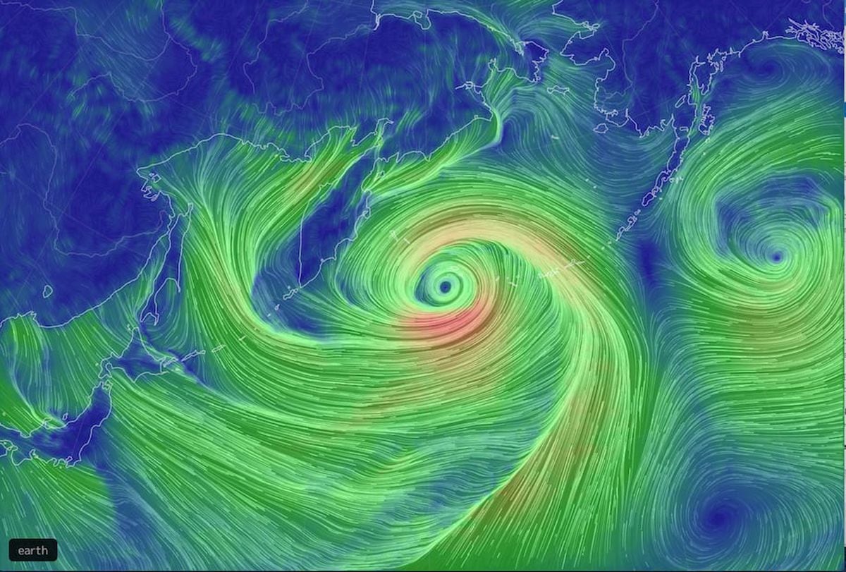
Computer model view of the Pacific storm, showing wind direction and speed. (Earth.nullschool.net)
A powerhouse storm explosively intensifying in the northern Pacific could rank as the strongest nontropical cyclone observed in that ocean basin.
The storm’s pressure has already dropped to 921 millibars on New Year’s Eve, which is even lower than extreme cyclones that formed in the same vicinity in 2014 and 2015. It now qualifies as the strongest storm on record to hit Alaska, according to Rick Thoman, a climate scientist at the University of Alaska at Fairbanks.
The lower the pressure, generally, the stronger the storm. The two northern Pacific cyclones that set records in 2014 and 2015 saw their pressures level off at around 924 millibars, which means this storm has eclipsed their intensities.
On Thursday morning, the National Weather Service’s Ocean Prediction Center confirmed that the storm is already generating 110 mph winds. On satellite imagery, the storm appears as a giant comma-shaped swirl of clouds, a textbook appearance for a strong nontropical weather system.
Author: Jason Samenow, Andrew Freedman, The Washington Post
Computer model view of the Pacific storm, showing wind direction and speed. (Earth.nullschool.net)
A powerhouse storm explosively intensifying in the northern Pacific could rank as the strongest nontropical cyclone observed in that ocean basin.
The storm’s pressure has already dropped to 921 millibars on New Year’s Eve, which is even lower than extreme cyclones that formed in the same vicinity in 2014 and 2015. It now qualifies as the strongest storm on record to hit Alaska, according to Rick Thoman, a climate scientist at the University of Alaska at Fairbanks.
The lower the pressure, generally, the stronger the storm. The two northern Pacific cyclones that set records in 2014 and 2015 saw their pressures level off at around 924 millibars, which means this storm has eclipsed their intensities.
On Thursday morning, the National Weather Service’s Ocean Prediction Center confirmed that the storm is already generating 110 mph winds. On satellite imagery, the storm appears as a giant comma-shaped swirl of clouds, a textbook appearance for a strong nontropical weather system.
At 7 a.m. Wednesday, the European model had analyzed the storm’s pressure at 972 millibars. It predicted the pressure will tumble to 921 millibars just 24 hours later, a 51-millibar drop. This plunge in pressure is double the criteria for “bombogenesis,” in which a storm’s pressure drops 24 millibars in 24 hours and earns the “bomb cyclone” moniker.
The Weather Service’s Ocean Prediction Center, which analyzed the storm at 921 mb, stated it ranks as “one of the strongest storms to ever impact the North Pacific.” The strongest wind gust recorded at Shemya Island in Alaska, located about 1,450 miles southwest of Anchorage, was 83 mph, with high winds and pounding waves battering the western Aleutian Island chain.
This 2020 Pacific bomb cyclone and its ultralow pressure represent an amazing contrast from an exceptional high-pressure zone over Mongolia, which may have set a world record on Tuesday.
At 7 a.m. local time on Tuesday, the mean sea-level pressure at Tsetsen-Uul, Mongolia, rose to 1,094.3 millibars, about 174 millibars higher than the projected pressure in the Pacific cyclone.
East Asia sits in the transition zone between these two extreme pressure centers, and the resulting northerly winds funneling over the Sea of Japan are predicted to cause a massive “sea effect” snowstorm for the Japanese Alps downwind.
Multiple feet of snow are forecast for the high terrain on Honshu through Saturday morning. This same region is just recovering from up to seven feet of snow earlier this month.

Meanwhile, the Pacific storm, in addition to unleashing winds topping 100 mph, is predicted to generate waves over 45 feet over the open waters.
Such storms generally go unnoticed except for meteorologists and those with maritime interests such as shipping, military and fishing. They are common in winter, although this particular storm is likely to reach the upper echelon of those ever observed in terms of its intensity.
While their pressures are extremely low, they do not fall as low hurricanes and typhoons, which have been known to drop below 900 millibars.
“Unlike hurricanes, these large and powerful storms go unnamed,” Capital Weather Gang’s severe-weather expert Jeff Halverson wrote in describing these storms in 2015. “And unlike hurricanes, they derive their energy from an entirely different process. While hurricanes extract heat from the ocean, maritime cyclones create energy by drawing together warm and cold air masses. When the warm air rises and cold air sinks, the kinetic energy of swirling wind is generated.”
Halverson continued: “The juxtaposition of warm and cold air is also what powers the polar jet stream - and indeed, maritime cyclones and the jet stream are inextricably linked - the one feeding back upon, and enhancing, the other.”
Indeed, the European model forecasts the jet stream transiting the Pacific to reach astonishing speeds of 230 mph (200 knots) at an altitude of 30,000 feet Thursday into Friday.
This rip-roaring jet stream is likely to carry weather disturbances into the Pacific Northwest and even California over the next week.
The National Weather Service is predicting four to eight inches of rain from the coast of Northern California into Washington state over the next seven days. In the high elevations, snowfall will be extreme, measured in feet.
With the jet stream bombarding the West Coast and drawing in Pacific air, the eastern United States is expected to be generally mild next week as the flow of Arctic air into the Lower 8 is4 cut off.
No comments:
Post a Comment