Uncovered: 100 years of coastal transformation on Mersea Island

A team of community archaeologists from CITiZAN (the Coastal and Intertidal Archaeological Network) working in partnership with the local community on Mersea Island, Essex, have lifted the lid on the origins of rapid destruction of the island's coastal environment. With funding from the Natural Environment Research Council and the support of Mersea Island Museum, a unique community-led pilot project is helping to shape climate action locally and has the potential to support change on a national and even international level.
The findings from this project are brought together in an online exhibition, Changing Minds, Changing Coasts.
Researchers brought together an evocative collection of over 300 historical photos from private collections, postcards, and five hours of oral history, alongside a series of historical maps, which were then analyzed against archaeological and ecological indicators of coastal change. This exceptional dataset reveals a timeline of major changes to the foreshore, highlighting when human interactions and natural events combined to transform the island's coastline.
Oliver Hutchison, CITiZAN Lead Archaeologist, said: "The photographs, memories and keen observations of the Mersea community uncovered the complex story of coastal change in a way we didn't think possible for a citizen science project undertaken during COVID-19 lockdown conditions. This community-created data set is absolutely vital in helping us to understand what might happen to our coasts in the coming century and crucially, what we can do to shape that future."
A biodiverse foreshore
In the 1920s, Mersea was surrounded by vast, richly biodiverse marshlands. These mudbanks supported meadows of seagrass like eelgrass that played a vital role in reducing the impact of wave energy on the marshland
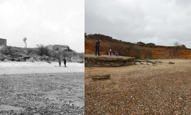 .Cudmore Grove cliffs, Mersea. Credit: Mersea Museum and CITiZAN
.Cudmore Grove, Mersea. Credit: Mersea Museum and CITiZAN
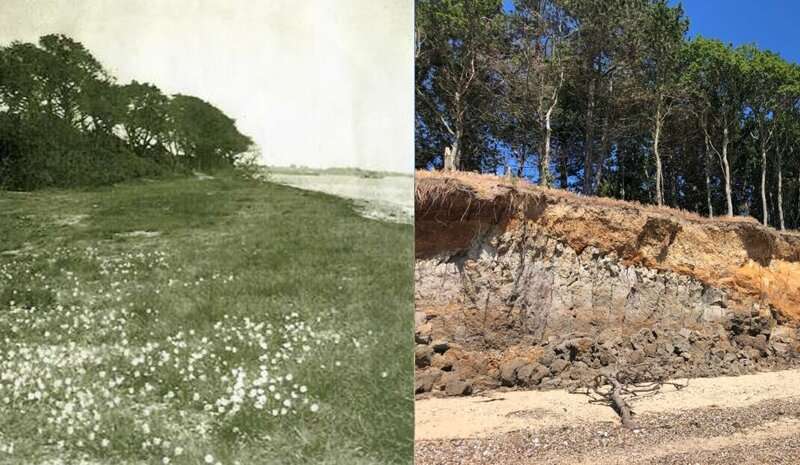 Cudmore Grove, Mersea. Credit: Mersea Museum and CITiZCudmore Grove cliffs, Mers
Post-war farming
In the 1940s, the use of fertilizer on farmlands in the post-war years polluted the Thames estuary, negatively impacting seagrasses on the foreshore. As the grasses died, the mudbanks became unstable and coastal erosion increased.
The Big Freeze
The winter of 1962-3 brought the Big Freeze, which covered the coast in snow killing billions of shellfish and affecting the livelihoods of the islanders.

Painting boats
During the 1960s, tributyltin, a new anti-fouling paint used on boat hulls, polluted the water further, threatening the dwindling numbers of native oysters and other shellfish.
This timeline of environmental changes demonstrates the impacts of the actions, technologies, and interactions of humans with the natural world at a local level. It shows that our actions have consequences for the ecosystems and biodiversity that support us. Living memories can be a powerful reminder of the need to be better prepared for the inevitable effects of climate change by working with nature to tackle coastal erosion. It also brings into sharp focus how information from coastal communities can and should be seen—a rich resource of data for climate action.
No comments:
Post a Comment