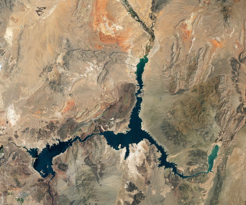
A satellite view of the water levels in Lake Mead in Nevada on July 3, 2022.
Photo courtesy of NASA Earth Observatory

A satellite view of the water levels in Lake Mead in Nevada on July 2000.

A satellite view of the water levels in Lake Mead in Nevada on July 2000.
Photo courtesy of NASA Earth Observatory
July 21 (UPI) -- NASA on Thursday released new satellite images depicting the dramatic changes in the water levels of Lake Mead over the past two decades.
The photos show just how much water the Nevada lake has lost through repeated drought cycles from 2000 until July 3, 2022.
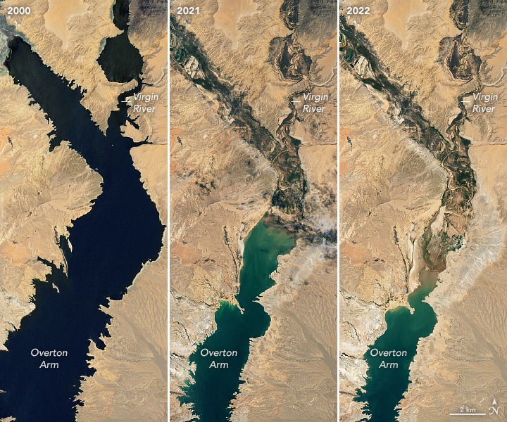
According to NASA, Lake Mead reaches maximum capacity when filled to about 1,220 feet, about 9.3 trillion gallons of water. In 2000, the reservoir was at about 1,215 feet and as of this month, it was at 1,043 feet, about 27% of its capacity.
The images show entire sections of the lake completely dried up, with faint "bathtub rings" visible in the surrounding land where the water used to be.
Lake Mead, a man-made reservoir first filled in 1937, is filled by the Colorado River. The lake provides drinking water and irrigation for millions of people in much of the western United States.
The stark contrast in the images highlights more than two decades of extreme drought and higher temperatures in the region, a result of climate change.
According to NASA, 74% of nine Western states are under drought conditions, including Colorado, where the headwaters of the Colorado River are located. A below-average snowpack in many locations has also worsened drought conditions
July 21 (UPI) -- NASA on Thursday released new satellite images depicting the dramatic changes in the water levels of Lake Mead over the past two decades.
The photos show just how much water the Nevada lake has lost through repeated drought cycles from 2000 until July 3, 2022.
According to NASA, Lake Mead reaches maximum capacity when filled to about 1,220 feet, about 9.3 trillion gallons of water. In 2000, the reservoir was at about 1,215 feet and as of this month, it was at 1,043 feet, about 27% of its capacity.
The images show entire sections of the lake completely dried up, with faint "bathtub rings" visible in the surrounding land where the water used to be.
Lake Mead, a man-made reservoir first filled in 1937, is filled by the Colorado River. The lake provides drinking water and irrigation for millions of people in much of the western United States.
The stark contrast in the images highlights more than two decades of extreme drought and higher temperatures in the region, a result of climate change.
According to NASA, 74% of nine Western states are under drought conditions, including Colorado, where the headwaters of the Colorado River are located. A below-average snowpack in many locations has also worsened drought conditions
No comments:
Post a Comment