Showing posts sorted by date for query NATURAL DISASTERS. Sort by relevance Show all posts

Thursday, September 10, 2026

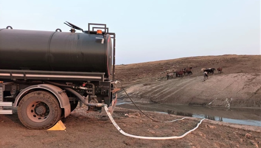
Bosnian army delivers water to thirsty wild horses during heatwave

Bosnian army delivers water to thirsty wild horses during heatwave
/ mod.gov.baFacebook
By IntelliNews September 9, 2026

Bosnia & Herzegovina's armed forces have turned some of their firefighting resources to delivering drinking water to wild horses threatened by hot and dry weather on a plateau near the western town of Livno.

The operation was ordered by the country's defence minister as the armed forces stepped up their support for civilian authorities dealing with natural disasters, including a wave of wildfires across the country.

Soldiers from the 1st Infantry Battalion of the 4th Infantry Brigade were sent to the Kruzi plateau, in the Livno area, with a military water tanker to ensure the horses had regular access to drinking water, a statement from the army said.

The Livno area's wild horses are one of Bosnia's best-known natural features, roaming the high plateau and surrounding mountains. The animals are considered an important part of the region's natural heritage and have become a familiar sight to residents and visitors.

The defence ministry said the horses were particularly vulnerable because of the adverse weather conditions, making access to water a priority.

"Wild horses in the Livno area represent one of the recognisable natural resources of our country and a valuable part of its natural heritage," the ministry said.

"Their preservation and care for their needs represent a shared responsibility and an important contribution to the protection of nature and the preservation of this unique symbol of the Livno region."

The military's intervention was also presented as an example of how the armed forces can assist beyond their traditional defence role when civilian authorities face emergencies.

"This humane engagement is another example of the commitment of the Armed Forces of BiH to, within their legal jurisdiction and available capacities, provide assistance and protect the natural values of Bosnia and Herzegovina," the ministry said.

The water delivery comes as the armed forces are being heavily deployed elsewhere in the country to combat wildfires, with helicopters and troops supporting civilian firefighting teams.

On September 8, the country's presidency approved four further requests for military assistance in fighting fires in Konjic, Drvar, Živinice and Trnovo. The defence ministry said the helicopter deployment in Konjic was a priority.

Since August 6, military helicopter units have carried out firefighting operations in areas including Trebinje, Konjic, Bihać, Mostar, Kalesija, Cazin, Bosanska Krupa, Bosansko Grahovo, Drvar and Prozor-Rama, while operations have also continued around Nevesinje and Mrkonjić Grad.

The ministry said 2026 had brought the armed forces' heaviest-ever involvement in helping civilian authorities tackle fires, underscoring their role in the country's disaster-response system.


Croatia invests €5.2bn in water management as climate risks grow

Croatia invests €5.2bn in water management as climate risks grow
/ IntelliNewsFacebook
By IntelliNews September 8, 2026

Croatia has invested €5.2bn in water management since 2016 as climate change brings more frequent droughts and floods and increases pressure on water resources, Prime Minister Andrej Plenković said on September 8.

Plenković said climate change was changing the country's approach to water management, requiring greater focus not only on flood protection but also on preserving water supplies during droughts, protecting groundwater and reducing losses.

"What may seem like a natural abundance to us today will be one of our most precious strategic resources tomorrow," Plenković said at an event marking 150 years of organised water management in Croatia.

Investments since 2016 have enabled 130,000 people to gain access to water, while 500,000 now have access to improved water supplies, he said. The possibility of connecting to public water supply has reached 96%, with 91% actually connected.

Around 515,000 residents have gained access to public drainage since 2016, while 2.3mn have access to improved drainage and wastewater treatment systems.

Plenković said 269 water-management projects worth €1.9bn had been approved under the EU-backed recovery plan, including €1.2bn in grants. Another €914mn in grants had been secured through the EU Competitiveness and Cohesion programme.

More than 300 km of flood embankments have been built or reconstructed over the past decade, while five major retention areas can hold around 2bn cubic metres of water.

"But investment in infrastructure must be accompanied by investment in knowledge, monitoring, prevention and institutional capacity to react before a problem arises," Plenković said.

Croatia's water-supply network now exceeds 50,000 km, while 118 wastewater treatment plants have been built or reconstructed in the past decade.


Wednesday, September 09, 2026

The disaster in Nepal and the need to build resilience: An ecosocialist energy transition perspective


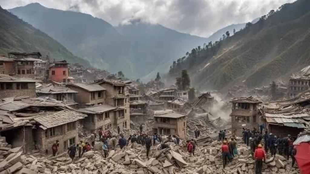
Nepal disaster

[Editor’s note: Filipino socialist activist Khyl Ramos, from the Partido Lakas ng Masa (PLM, Party of the Labouring Masses), will be speaking at Ecosocialism 2026, September 11-13, Magan-djin/Brisbane, Australia. For more information visit ecosocialism.org.au.]

Nepal and the Philippines share a fundamental climate condition: both are low greenhouse-gas emitters yet highly exposed to climate risks and suffer from climate disasters created by the rich countries of the Global North. In 2024, Nepal and the Philippines emitted only 0.63 and 1.51 tons of greenhouse gases per person, respectively, compared with more than 14 tons per person in the United States and Australia.

Global warming is a major driver of increasing glacier retreat and ice loss, contributing to greater melting and floods risk in the Himalayas. Warming alters the glacier–lake–mountain system in ways that make certain catastrophic events more likely. This is now a demonstrable pattern.

The chain is roughly: Global warming → glacier retreat and ice loss → more and larger glacial lakes → unstable ice, rock and moraine slopes → sudden collapse or overtopping → glacier lake outburst flood (GLOF) and flash flood → downstream destruction.

The most immediately vulnerable Hindu-Kush Himalayan countries, apart from China and India, include Afghanistan, Bhutan, Nepal and Pakistan, all with very low levels of emissions. The scale of the disaster, which spread across borders, demonstrates the stark reality of the existential climate emergency.

The disaster in Nepal’s Rasuwa District and other affected areas exposed entire communities, hydropower and border-trade workers, security personnel and downstream populations to severe and rapidly cascading risks. Nepal’s government, the National Disaster Risk Reduction and Management Authority (NDRRMA), security forces, medical teams and emergency services mobilised search, rescue and evacuation operations and worked to restore roads, bridges, electricity, telecommunications and water services.

But the speed of the event, the narrow Himalayan valleys and communications failures left little time for warning or evacuation. Timure and Rasuwagadhi were severely affected, while transport, power, communications and Nepal–China trade were disrupted. Beyond the immediate destruction, displacement and prolonged disruption to hydropower, tourism, transport and local livelihoods will produce wider social and economic consequences.

The growing danger of cascading high-mountain hazards

The disaster in Nepal’s Bhotekoshi–Trishuli corridor reveals the growing danger of cascading high-mountain hazards. Ice or rock failures can trigger landslides and debris flows, block rivers, generate sudden surges or outburst floods and devastate downstream communities within hours. Cryospheric, geological and hydrological hazards can combine rapidly and cross national borders.

This exposes a deeper problem: resilience cannot mean simply responding more effectively after infrastructure fails. We must ask why communities and critical infrastructure are increasingly concentrated in landscapes exposed to interconnected and difficult-to-predict hazards.

Beyond individual infrastructure projects

Official assessments show that this was not a collection of isolated hydropower failures. The Ministry of Energy initially placed about 754 MW of generation capacity within the affected or damage zone.

Subsequent assessments identified around 431 MW of generation as lost or disconnected. According to preliminary reports from the Nepal Electricity Authority (NEA), 431 MW of operating generation across 12 projects was immediately affected, including 406.1 MW of hydropower and a 25 MW solar plant. Fifteen hydropower projects under construction, with a combined capacity of about 470 MW, also sustained damage.

The affected system included generation facilities, substations, transmission infrastructure, roads and construction sites across the Bhote Koshi–Trishuli corridor. These included Rasuwagadhi, Chilime, Upper Trishuli 3A, Trishuli, Devighat, Sanjen Khola, Sanjen, Mailung Khola, Salasungi Sanjen and Langtang Khola, as well as the 25 MW solar plant and strategically important 220 kV Nuwakot substation.

This challenges conventional project-by-project infrastructure planning. Projects are usually assessed by installed capacity, financial returns, construction costs and electricity output. But the real risk is systemic:

What happens when multiple power projects, transmission corridors, roads, settlements and communities are exposed to the same cascading hazard?

The cumulative impact of development

The Himalayas and their river systems are shared ecological and social systems, not simply collections of sites for competing infrastructure projects. The key question is therefore not only how many megawatts a river or valley can generate, but what cumulative risks development creates across an entire river basin.

Hydropower depends on transmission networks, roads, bridges, communications and access routes; communities and economic activity depend on the same corridors. When one hazard strikes, these systems can fail together.

Damage to one component can disable others, while disrupted transport and communications can prevent emergency services and workers from reaching affected areas. The result is cascading infrastructure vulnerability — the overall failure can be far greater than the sum of individual project failures.

This changes the question of reconstruction. With preliminary national reconstruction requirements estimated at US$4–5 billion, and energy among the major infrastructure losses, resilience cannot mean simply rebuilding what existed before. Reconstruction must reconsider where, how and at what scale infrastructure is built.

From downstream response to source-to-downstream risk management

The disaster also exposes the limits of conventional rainfall-based flood warnings. Risk management must cover the entire hazard chain — from high-mountain sources to downstream settlements.

This requires transboundary monitoring and data sharing on glaciers, snow and ice, landslides, avalanches, seismic activity, river blockages and river conditions. Early-warning systems must integrate cryospheric, seismic, geomorphological and hydrological indicators rather than treating floods as isolated rainfall events.

It also requires anticipatory evacuation: clear triggers, safe areas, evacuation routes, community drills, sirens and redundant communications. Infrastructure and land-use planning must anticipate cascading hazards through alternative access routes, backup power and communications.

Community-based early-warning experience across the Hindu Kush Himalaya is crucial. Information alone does not save lives; communities must be able to interpret warnings and act on them. Real-time risk information must reach local decision-makers and communities in a form they can understand and use.

Observation by ICIMOD specialists after the Lhende Khola event reinforce this point: a cryosphere hazard can become a catastrophic settlement flood within hours. As the pace of cryospheric change accelerates, national institutions acting separately will struggle to keep up. Regional cooperation is therefore not optional but increasingly necessary.

Resilience requires regional planning

Nepal cannot address these risks alone. Himalayan river systems and hazards cross Nepal, Tibet/China, Bhutan, India and other states. Institutions such as SAARC and ICIMOD, together with other regional mechanisms, can provide foundations for cooperation — but their orientation must shift from fragmented development toward collective resilience and ecological sustainability.

This is not merely a technical question. It is political. Development is largely organised through competing national agendas, corporate investment and individual projects. Each project may appear rational in isolation while collectively increasing ecological risk and concentrating communities and critical infrastructure in vulnerable landscapes.

The alternative is democratic regional planning that meets social needs within ecological limits, directs public investment toward these goals, and ensures an equitable distribution of benefits and risks.

This principle has major implications for the energy transition. The objective cannot simply be to replace fossil-fuel electricity with more renewable megawatts. Renewable infrastructure can also reproduce concentrated vulnerability when built in exposed landscapes without basin-wide risk assessment.

Energy planning must therefore compare large projects with alternatives such as distributed solar, storage, microgrids and smaller-scale community energy. A resilient renewable-energy system should decentralise where appropriate, use robust interconnected networks, incorporate storage and microgrids, and be designed around community needs and participation.

Above all, it must reduce concentrated risk. If one valley, transmission corridor or substation carries a large share of regional generation, a single disaster can produce system-wide consequences.

The central question is not simply, “How much renewable energy can we build?” It is: What kind of energy system can meet social needs, remain within ecological limits and withstand cascading climate and geological hazards?

An ecosocialist approach to resilience

The lesson from Nepal extends across the Asia-Pacific. Climate disasters do not respect national borders, yet political responses remain overwhelmingly organised within them. Glacial instability, landslides, debris flows, river surges and flooding in the Himalayas illustrate a wider regional reality: typhoons, floods, droughts, heatwaves, wildfires and sea-level rise increasingly affect interconnected communities and economies across borders.

Yet governments continue to compete for investment, energy resources, strategic infrastructure, supply chains and markets even when the ecological systems on which they depend are transboundary. Rivers, coastlines, fisheries, forests, glaciers, atmospheric systems and electricity networks cannot be governed effectively as isolated national assets. Infrastructure built upstream or in vulnerable coastal and mountain regions can transfer risks far beyond project and national boundaries.

The contradiction becomes sharper as governments expand military spending and prepare for geopolitical conflict. Enormous public resources are being directed toward weapons, military infrastructure and strategic competition precisely when societies urgently need investment in climate adaptation, disaster preparedness, resilient infrastructure, public health, food and water security, and just energy transitions.

This points to a different conception of security: human and ecological security rather than military security.

Regional cooperation should prioritise shared disaster-risk monitoring, early-warning systems, transboundary river-basin governance, climate-resilient infrastructure, regional energy cooperation, emergency response capacity and protection of vulnerable communities.

Resilience therefore requires democratic public planning at local, national and regional levels, linking the energy transition with ecological protection, disaster resilience, decent livelihoods and social ownership. It means placing social need before private returns, ecological limits before endless infrastructure expansion, regional cooperation before competitive development, and public investment before speculative finance.

A genuinely just energy transition is more than changing the technology used to generate electricity. It requires transforming how energy, infrastructure and natural resources are planned, financed, owned and governed. The goal is a socially just, ecologically sustainable and resilient energy system — and a regional model of sustainable and sovereign industrialisation.

The Nepal disaster makes the choice immediate. We must move from fragmented projects to interconnected systems; from downstream response to source-to-downstream risk management; from national competition to regional cooperation; from private accumulation to public investment; and from market-driven development to democratic planning based on social need and ecological limits.

The objective is not merely to protect infrastructure from disaster. It is to build societies that are less vulnerable to disaster in the first place.
Tuesday, September 08, 2026

French firefighters begin six-week strike over funding after record summer fires

French professional firefighters launch a six-week nationwide campaign on Tuesday, demanding more funding, staff and better protection for their health after a summer of unprecedented wildfires.


Issued on: 08/09/2026 -  RFI

France's firefighters have been heavily called upon this summer to tackle a series of wildfires, like here in Gironde, and are now campaigning for better pay and more ressources. © Emma Da Silva / AP


At least 120,000 hectares went up in flames in France this summer – a record since satellite imagery was first used to measure wildfires 20 years ago.

Four firefighters died in July, and more than a hundred have been injured over the summer while responding to or travelling to fire incidents.

Faced with such pressure but also an increasing number of emergency call-outs, eight unions are calling for more than six weeks of strike action, beginning Tuesday.

The unions want more financial and material resources, as well as mass recruitment of professional firefighters.

"The system is not suffering from simple poisoning but from cancer," said Rémy Chabbouh, a spokesman for the SUD union. He said the crisis required major treatment and called for "action commensurate with the challenges".

Even if the strike action is widely followed, emergency services are unlikely to be affected.

The country's 44,300 professional firefighters can be ordered to work by fire and rescue services or requisitioned by local state representatives to ensure public services continue.


Funding pressures

The campaign begins as the government presents unions with the broad outlines of a proposed civil security law, following a year of consultations launched in mid-2024.

The talks were meant to lead to an ambitious law modernising a system seen as running out of steam, with additional funding. But unions say they have so far produced no results.

Their campaign is due to end on 20 October when parliament begins examining France's 2027 budget.

Unions therefore want to keep up the pressure on the government until then.


France's President Emmanuel Macron thanks personnel engaged in firefighting efforts during a visit to the Departmental Fire and Rescue Operational Center (CODIS) in Bordeaux, 27 July, 2026. via REUTERS - KENZO TRIBOUILLARD

Their main demand is for "sustainable, fair and ambitious funding" for local fire and rescue services, known as SDIS whose operating costs rose from €3.9 billion in 2012 to €5.2 billion in 2025, according to the Observatory of Local Public Finance and Management.

"The strike is about funding for the SDIS, not the civil security budget," said Xavier Boy, a spokesman for the inter-union group.

He said the €880 million civil security budget was used for national resources including reinforcements, aircraft, water bombers and helicopters.

Funding for local fire and rescue services amounts to about €6 billion, he said, with the state contributing about €1 billion – a share he described as insufficient.

Emergency assistance

Several parliamentary reports have pointed to growing difficulties as firefighters face more medical emergencies and natural disasters.

Professional firefighters, more than half of whom also serve as part of France's 200,900-strong volunteer brigade, are calling for a greater focus on their core emergency and rescue work.

Emergency assistance to people accounted for more than 4.89 million callouts in 2025, or 87 percent of firefighters' activity.

"We talk about forest fires now. Tomorrow, we'll talk about floods," said Alain Laratta, secretary general of the Avenir Secours union. But firefighters were under pressure all year because they were increasingly being called on for work that was not their responsibility, he said.

Unions plan further action in Paris on 27 and 28 September before a demonstration on 29 September.

(with newswires)

Monday, September 07, 2026

Nepal Flood Disaster Exposes Cascading Threats In Himalayas – Analysis


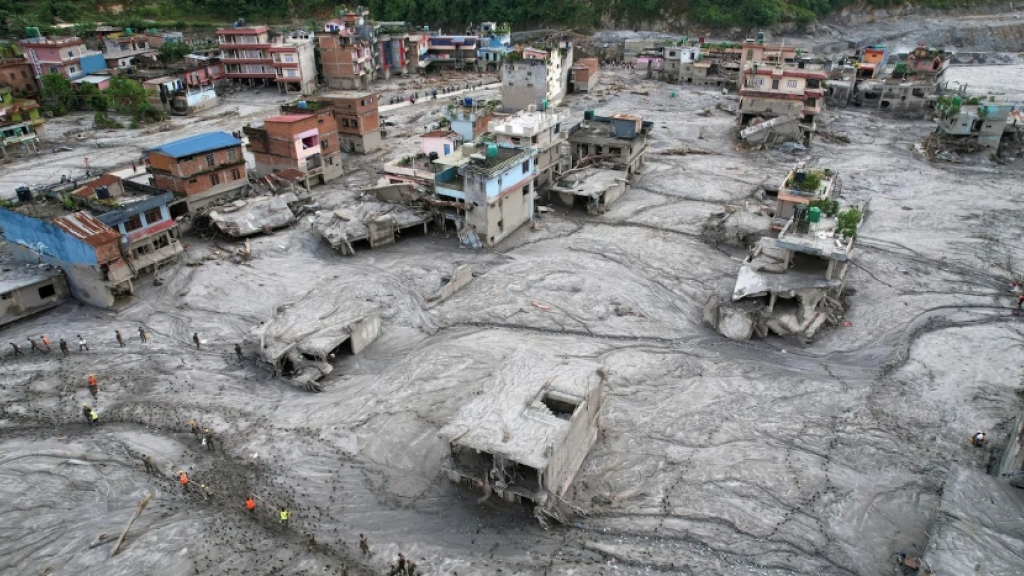
Many homes and infrastructure near the Bhotekoshi River were damaged or destroyed during the devastating flash floods that left thousands of people missing. Copyright: Gautam/UNICEF

September 4, 2026

By Tauseef Ahmad and Sajid Raina

Key Takeaways:

A late-August cascade in the Nepal–China border highlands—ice, rock and debris, likely on the Lhende Khola—apparently dammed a Bhotekoshi tributary for ~18–19 hours, then burst on 26 August. UN figures cited: more than 1,000 dead, nearly 4,000 missing, ~11,800 rescued; roads, bridges, hydropower and the Tibet trade route were wrecked.

Analysts (Planet Labs, IRDR) point to mass failure, not a rain-only flash flood. Steep valleys turned the release into a debris surge. Experts say Hindu Kush Himalaya hazards now chain—glacier collapse, landslide, blockage, flood—so single-hazard warnings miss the start kilometres upstream. Glaciers there lost ~12% of area from 1990–2020; ice loss has doubled since 2000.

Planning should treat compound risk across borders (Chamoli 2021 is a parallel). Satellites reconstructed this event and watch new lakes, but cannot reliably time a collapse. Call is for mixed systems: imagery, gauges, seismic sensors, cameras, forecasts and community alerts—plus fewer unmonitored glaciers.


A catastrophic flood in Nepal that left thousands missing started with a collapse of ice and rock high in the mountains—a warning that disaster planning must prepare for chains of hazards, not isolated events, say experts.

The cascade of ice, rock and debris that tumbled through the Nepal-China border region last week probably blocked a tributary of the Bhotekoshi river, forming a dam, before bursting downstream with devastating force, according to disaster analysis.

The torrent arrived in Nepal’s Rasuwa district with little warning, ripping through settlements along the Bhotekoshi river system, destroying bridges, roads and hydropower infrastructure and cutting a vital trade route with Tibet.


More than 1,000 people have been confirmed dead, with almost 4,000 still missing and around 11,800 rescued, according to UN figures on Tuesday (1 September). Thousands are in need of humanitarian assistance, hindered by blocked roads and damaged bridges.

Experts say the disaster illustrates a growing problem across the Hindu Kush Himalaya: hazards that once might have been assessed separately—glacier collapse, landslides, avalanches, river blockages, floods and even earthquakes—can interact within minutes or hours, creating an event that is much larger than any one of them.

“Most people think of flash floods as being caused by heavy rainfall,” said Liz Stephens, professor of climate risks and resilience at the University of Reading, in the UK.

But in high mountain regions such floods can result from “complex chains of hazards, including landslides, avalanches and glacial lake outburst floods”, she added.

That complexity, says Stephens, makes early warning particularly difficult.
Tributary blocked

Analysis of satellite imagery from US aerospace and data analytics company Planet Labs suggests that a substantial section of glacier and surrounding rock collapsed at high altitude near the Nepal-China border, sending an enormous mass of ice, snow and debris towards the valley.

The collapse appears to have affected the Lhende Khola, a tributary that becomes part of the Bhotekoshi river system.


A rapid-analysis report released by the Integrated Research on Disaster Risk (IRDR) on Friday (28 August) said the event was likely caused by an “ice, rock and soil mass failure” rather than intense rainfall.

The material probably blocked the river for about 18 or 19 hours, forming a natural dam which then gave way on the morning of 26 August, unleashing masses of water, ice, rocks and sediment, the report said.

Funnelled by the steep Himalayan terrain, the surge became a fast-moving mixture of water and debris capable of carrying huge boulders, destroying bridges and erasing riverbanks.

The rapid-analysis report said the steep gradient and narrow valley accelerated and concentrated the flow, while the heavy debris load increased its destructive power.

Chinese state broadcaster CCTV said the flood was “caused by glacier instability under the long-term effects of global warming” and described this as a “new and prominent feature of cryosphere disasters” on the Tibetan plateau.
A view of the Himalayas in Nepal

‘Bigger than the atom bomb’

Experts say these findings highlight the need for change in disaster monitoring.

A conventional flood warning system may detect rising rainfall or river levels. But a cascading cryospheric event can begin kilometres away, and at much higher elevation, with no obvious warning for communities downstream.

The International Centre for Integrated Mountain Development (ICIMOD) argues that disaster planning in the region needs to move away from treating hazards independently.

“With the nature of disaster risks rapidly mutating in the region, disaster risk reduction strategies can no longer evaluate hazards in isolation,” Saswata Sanyal, a disaster-risk reduction specialist at ICIMOD, told SciDev.Net.

“The era of preparing for a single, predictable hazard is over.”

The disaster comes just over a year after another major flood affected the same Lhende Khola-Bhotekoshi system.

In July 2025, flooding in the area was linked by Nepalese authorities to a glacial lake outburst. The recurrence is raising questions about whether the river corridor is becoming a particularly exposed pathway for cryosphere-related hazards.

A 2026 ICIMOD assessment found that glaciers across the Hindu Kush Himalaya lost about 12 per cent of their area between 1990 and 2020, and the rate of ice loss has doubled since 2000.

As glaciers retreat, new lakes can form, slopes can lose the support provided by ice, and frozen ground can become unstable. A glacier collapse can then entrain rock and soil, turning an initial ice avalanche into a debris flow capable of travelling tens of kilometres.

Research published in April on Himalayan hanging glaciers found that rising temperatures and shifting regional precipitation patterns are reducing glacier stability and increasing the risk of ice avalanches. The authors identified more than 219 hanging glaciers in northern India’s Alaknanda basin and warned that break-offs can cause physical damage and trigger secondary hazards, including glacial lake outburst floods.

A separate study on ice-rock avalanches in the Himalayas similarly concluded that such failures can rapidly transform into high-velocity debris flows, while stressing the difficulty of identifying precursors, or warning signs.

Geohazard expert Basanta Raj Adhikari, director of Tribhuvan University’s Centre for Disaster Studies, in Nepal, described the 26 August flood as an unprecedented event in the region.

“In my research career, I haven’t seen a bigger flood event than this in the Himalayan landscape,” Adhikari said, attributing its extraordinary force to the enormous volume of ice and debris that descended from the mountains.


“I calculated the amount of energy, which is bigger than the atom bomb that happened in Hiroshima,” he added.

He said the scale of the event demonstrates the immense destructive potential of cascading ice, rock and water hazards in the Himalayas.
Neighbours at risk

The disaster also raises questions about disaster preparedness in the wider region.

The Hindu Kush Himalaya stretches across Afghanistan, Pakistan, India, Bhutan, Bangladesh, and Myanmar, as well as Nepal and the Tibetan plateau, connecting communities through river systems that cross political boundaries.
This infographic was designed using AI.

In India, the 2021 Chamoli disaster demonstrated the destructive potential of a similar ice-rock cascade. A massive collapse in Uttarakhand sent water, ice and debris through the Rishiganga valley, killing more than 200 people and destroying hydropower facilities.

Scientists are increasingly treating such events as compound hazards rather than isolated disasters.

Across Bhutan and Nepal, glacial lakes are being monitored for possible outburst floods. In Pakistan, rapidly changing glaciers and high-mountain valleys create a complex combination of flood, landslide and avalanche risks.


A recent UNDP assessment of human security in the Hindu Kush Himalaya warned that climate impacts can cascade across interconnected food, water and energy systems, creating compound threats that are greater than individual hazards considered separately.
Satellite warnings

Experts say the Rasuwa disaster also provides a powerful demonstration of the potential—and limits—of satellite technology.


Images shown above were captured by the Copernicus Sentinel-2 mission showing the Nepal glacier collapse and flood before and after (24/27 August 2026). Source: ESA (CC BY 4.0 INT)

Satellite images helped scientists reconstruct what happened in an otherwise extremely difficult-to-access area. High-resolution imagery can reveal changes in glacier geometry, newly formed lakes, landslide scars, blocked rivers and altered drainage channels.

In the aftermath of the flood, authorities have used satellite observations to monitor newly formed lakes upstream that could pose additional risks if their natural barriers fail.


But identifying a disaster after it happens is very different from predicting it beforehand.

Ishfaq Ahmad, a satellite scientist based in Nepal, told SciDev.Net that while scientists can identify and assess potentially dangerous glacial lakes using satellite imagery and visual observations, predicting the exact moment when a lake will burst remains a challenge.

“Glacial lakes can be seen with our eyes and through satellite data. We can assess whether the lakes are potentially dangerous or not,” Ishfaq said.

But he said sudden triggers, such as rockfalls or ice collapses, can occur too rapidly for orbiting satellites to detect them in advance.

Satellites do not continuously observe every Himalayan slope at the resolutions needed to reliably detect an imminent collapse. Clouds can obscure optical imagery, while revisit times can leave gaps between useful observations.

Ground sensors can provide continuous measurements but installing and maintaining them is challenging in remote, high-altitude terrain, where field observations remain sparse.

The answer, therefore, is unlikely to be a single technology.

Scientists increasingly argue for combining satellite imagery with seismic sensors, river gauges, automated cameras, weather forecasts, glacier monitoring and local community warning networks.

ICIMOD has noted that only a fraction of Himalayan glaciers are adequately monitored, leaving large areas as blind spots. It has called for better data and for scientific information to be translated into decisions that communities can act on.


This piece was produced by SciDev.Net’s Global desk.


About Tauseef Ahmad
Tauseef Ahmad is a freelance journalist based in South Asia. His work has appeared in Al Jazeera, TRT World, The Polis Project, The Guardian, and other publications.
View all posts by Tauseef Ahmad →


About Sajid Raina
Sajid Raina is a freelance journalist based in South Asia. His work has appeared in The Guardian, TRT World, Diplomat, News International and other publications.
View all posts by Sajid Raina →
A Secluded Russian Island May Hold Bioweapons Secrets – Analysis


An illustration shows Russian President Vladimir Putin (left), a satellite image of Lisy Island, and Vladimir Maksimov, head of the Center of Experimental Physiology located there.
Credit: RFE/RL


September 4, 2026

By RFE RL

By Mark Krutov, Sergei Dobrynin, Systema and RFE/RL’s Russian Service


Key Takeaways:

An RFE/RL-led report notes that the Center of Experimental Physiology on Lisy Island in Tver’s Vyshnevolotskoye Reservoir—closed after a 2023 “natural monument” designation—is led by Vladimir Maksimov, a former official of the Defense Ministry’s 48th Central Research Institute, which the U.S. sanctioned in 2020 over alleged biological and chemical programs. Ukraine’s HUR on 21 August claimed the center works with dangerous pathogens for the armed forces; Maksimov did not comment.

The island had imperial and Stalin-era animal-disease labs. The FMBA-run center was named in spring 2021; satellite images from July 2026 show a finished lab, housing and a helipad. Maksimov previously headed a virology unit later folded into the 48th Institute and, in older interviews, discussed hemorrhagic-fever viruses while calling the work defensive.

FMBA, which also oversaw COVID vaccine work, was placed under Putin in 2024; he has called it “medical special forces.” Systema has previously tied FMBA-linked institutes to Novichok and other poisoning cases. Moscow says research is only for protection. Analyst Milton Leitenberg doubts COVID fully explains the 2021 expansion and notes isolated-island siting echoed Soviet safety practice; he treats any wartime BW role as unproven.

A scientific facility on a secluded island that is closed to the public is affiliated with an institute accused of developing biological weapons for the Russian military, RFE/RL’s Russian Service and Systema, RFE/RL’s Russian investigative unit, have found.

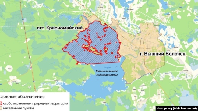
The islands in Vyshnevolotskoye Reservoir, in the Tver region northwest of Moscow, were once popular with locals for fishing and berry picking. After the northern part of the reservoir was designated as a “natural monument” in 2023, access to many of them — including Lisy Island, now home to the Center of Experimental Physiology — was restricted.

The blue area shows part of Russia’s Vyshnevolotskoye Reservoir in the Tver region, designated as a “natural monument” by Russian authorities.


Systema and RFE/RL’s Russian Service determined that the center’s head, Vladimir Maksimov, is a former official of the Russian Defense Ministry’s 48th Central Research Institute, the country’s leading developer of defensive systems against biological weapons. It was blacklisted by the United States in 2020 along with two other Russian institutes for allegedly continuing biological and chemical weapons programs.

Separately, the federal parent agency of the new center on Lisy Island has figured in investigations into the poisonings of Russian opposition politician Aleksei Navalny and former Russian GRU officer Sergei Skripal with a Novichok-type nerve agent.
‘Experimenting With Dangerous Viruses’

Although largely unused by the Russian government in recent decades, Lisy Island already had a rich history of scientific research involving infectious diseases, predating the state’s latest construction there.

It hosted a veterinary laboratory in Imperial Russia and a facility for “conducting acute experiments involving infectious diseases of agricultural animals” during Josef Stalin’s rule of the Soviet Union.

In spring 2021 — about a year before Russia’s full-scale invasion of Ukraine — the settlement on the island became the Center of Experimental Physiology, part of Russia’s Federal Medical-Biological Agency (FMBA), with one of the country’s newest research laboratory complexes being constructed there.

Construction of the Center of Experimental Physiology was completed by the autumn of 2025, and satellite images of Lisy Island from July 2026 show a large building — the lab — as well as a landscaped park, housing for personnel and guests, and a helicopter landing pad.


But on August 21 of this year, Ukraine’s military intelligence agency, HUR, claimed that the Center of Experimental Physiology was “experimenting with dangerous viruses and other pathogens for the benefit of the [Russian] armed forces.”

Systema and the RFE/RL’s Russian Service, also known as Radio Svoboda, found a connection to Russia’s armed forces through the center’s head, Maksimov.

Prior to leading the center on Lisy Island, Maksimov had long been involved in biological research for the Russian military.

Judging by his publicly available work, he had mostly specialized in exotic and deadly hemorrhagic fever viruses, such as Ebola and Marburg. Both pathogens were considered in the Soviet Union as potential foundations for the development of biological weapons.

“Ebola hemorrhagic fever…in our view, is one of the most likely agents for biological warfare,” Maksimov said in a 2004 interview with the Russian weekly Voyenno-Promyshlenniy Kuryer (Military-Industrial Courier).

Once described as a “young and enterprising colonel of the medical service,” Maksimov led Russia’s military unit 44026, the Virology Center of the Defense Ministry’s Institute of Microbiology, from 1999 to 2006.

In 2008, unit 44026, in the city of Sergiyev Posad outside Moscow, was effectively renamed the 48th Central Research Institute of the Russian Defense Ministry, which Western intelligence agencies believe brings together some of the remnants of the Soviet biological-weapons development program.

Maksimov continued to work at the facility in 2008, but apparently no longer as director.

In a 2005 interview with the newspaper Trud, Maksimov asserted that that the purpose of the Sergiyev Posad center was defensive.

“Contrary to what is sometimes attributed to us, we are not engaged in ‘spreading death.’ Our task is exactly the opposite — to be able to combat it,” he said.

Systema found a visiting card for Maksimov from 2022 on an online auction site. He did not respond to phone calls and messages sent by RFE/RL seeking comment.

In 2024, Radio Svoboda found that the center in Sergiyev Posad had also undergone a major expansion since Russian President Vladimir Putin launched the full-scale invasion of Ukraine in February 2022.
COVID As Timely Cover?

Systema and Radio Svoboda found that the expansion of Russia’s research facilities on Lisy Island and in Sergiyev Posad had effectively begun late in 2021, a few months before the invasion and against the backdrop of the subsiding global COVID-19 pandemic.


Both the 48th Central Research Institute and the Lisy Island facility’s overseer, the FMBA, were officially involved in the development of Russian COVID-19 vaccines.

However, Milton Leitenberg, a researcher at the Center for International and Security Studies at the University of Maryland School of Public Policy and an expert on the Soviet biological weapons program, expressed doubt that the research expansion was Moscow’s response to the pandemic.

“The coincidence of dates of the Russian public health response to the COVID pandemic and Putin’s decision on invading Ukraine are of course notable,” Leitenberg told Systema and Radio Svoboda. “Nevertheless, given that no later than mid-2021, Putin made the decision to invade Ukraine…the expansion of Russian biological weapons research, as well as the inclusion of new laboratories such as Lisy Island, must be viewed in that context.”

While the role Russia might have intended biological weapons to play in the war “remains a mystery,” he said, the development work may represent what he called “an opportunistic expansion” of biological research activity alongside other military sectors.

Leitenberg said the appointment of Maksimov and other senior former officials of the 48th Central Research Institute to lead the Center for Experimental Physiology appears to be a strong argument that the new facility on Lisy Island may represent an enlargement of military activities despite the formally civilian status of the FMBA.

Lisy Island’s location may also be telling. In the Soviet period, Leitenberg said, placing the laboratory on an isolated patch of land in the middle of a reservoir served as a safety measure — an additional layer of protection for local residents in the event that a dangerous pathogen escaped.

He also recalled that the main testing laboratory of the Soviet biological weapons program on Vozrozhdeniya Island in the Aral Sea, in what is now independent Uzbekistan, was likewise surrounded by water on all sides.
‘Medical Special Forces’

Formed in 2004, the FMBA handles many of Russia’s unconventional public health challenges. Among other things, it provides medical support for athletes and cosmonauts, people working in closed cities. It also responds to disasters and industrial accidents, and handles radiation, chemical, and biological incidents.

In 2024, the oversight of the agency was transferred from the Russian government directly to Putin, a move described in parliament as the “right decision” that “would help address issues of a confidential nature.”

Putin meets regularly with FMBA officials, most recently in August, and has previously referred to the agency as “medical special forces.”

In a 2020 investigation into an updated version of Novichok, Systema found that a research institute in Russia’s Leningrad region overseen by the FMBA was producing a number of biological supplements developed by a scientific center called Signal.

Signal was later found to have worked with epibatidine, a poison derived from an Ecuadorian frog that, according to a leading theory, was used to poison Navalny in the Arctic prison where he died suddenly in February 2024.

Officially, Moscow denies conducting research aimed at developing biological and chemical weapons, claiming that its research is limited to developing means of protection against their potential use.

However, the investigation into Navalny’s poisoning suggested that Russia continued its work on developing such weapons, in violation of the respective international conventions it had ratified.


Adapted by Mykyta Peretiatko from the original Russian-language report.Mark Krutov is a correspondent for RFE/RL’s Russian Service and one of the leading investigative journalists in Russia. He has been instrumental in the production of dozens of in-depth reports, exposing corruption among Russia’s political elite and revealing the murky operations behind Kremlin-led secret services. Krutov joined RFE/RL in 2003 and has extensive experience as both a correspondent and a TV host.

Sergei Dobrynin is one of the leading investigative journalists in Russia. He has been instrumental in the production of dozens of in-depth reports, exposing corruption among Russia’s political elite and revealing the murky operations behind Kremlin-led secret services. He joined RFE/RL in 2012.

Systema is RFE/RL’s Russian-language investigative unit, launched in 2023. The team conducts in-depth investigative journalism, producing high-profile reports and videos in Russian.

RFE/RL’s Russian Service is a multi-platform alternative to Russian state-controlled media, providing audiences in the Russian Federation with informed and accurate news, analysis, and opinion.


About RFE RL
RFE/RL journalists report the news in 21 countries where a free press is banned by the government or not fully established.
Vi=ew all posts by RFE RL →


Thursday, September 03, 2026

Urgent Global Response Needed to Prepare for ‘Literally Off the Charts’ Supersized El Niño, Says UN

“The science leaves no room for doubt: the planet is in uncharted waters, and those waters are heating up.”


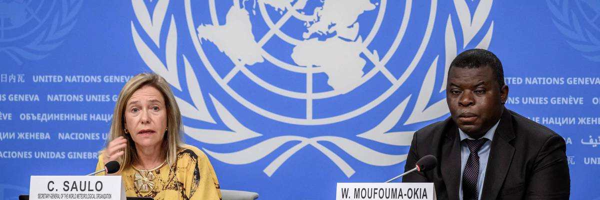
World Meteorological Organization Secretary-General Celeste Saulo and chief of climate prediction Wilfran Moufouma-Okia attend a press conference in Geneva, Switzerland on September 3, 2026.
(Photo by Fabrice Coffrini/AFP via Getty Images)


Brad Reed
Sep 03, 2026
COMMON DREAMS

Officials at the United Nations are warning that governments around the world must urgently prepare for the impacts of an El Niño climate pattern that is being “supersized before our eyes.”

The UN’s World Meteorological Organization (WMO) on Thursday provided an update on El Niño, projecting with near certainty that it would persist at least through Februrary 2027.


‘It Is a Warning’: Super El Niño Pushed Ocean Temps to Hottest on Record for July


Study Suggests Climate Crisis Is Supercharging ‘Godzilla’ El Niños

El Niño is a phenomenon that produces above-average temperatures in the Pacific Ocean, which then disrupt weather patterns elsewhere in the world. In its update, WMO said that this year’s El Niño projects to be historically intense.

“Forecasts indicate further strengthening of El Niño in the coming months, with the event forecast to reach very strong intensity before peaking towards the end of the year,” WMO said. “A very strong El Niño increases the likelihood of significant shifts in temperature and rainfall patterns in many parts of the world.”

The organization emphasized, however, that El Niño’s impacts are not predictable and vary widely by region.

WMO Secretary-General Celeste Saulo said the latest projections show that El Niño “has the potential to deliver a massive blow to communities and economies across the world” in the form of droughts, floods, and other climate-related disasters made more intense by the continued extraction and burning of fossil fuels.

“This exceptional El Niño demands exceptional preparation and response,” Saulo said. “Never before in the 50-year history of the World Meteorological Organization have we launched such a major mobilization with National Meteorological and Hydrological Services who are on the frontline of delivering the forecasts and services to save lives and livelihoods.”

While speaking with reporters in Geneva, Switzerland on Thursday, Saulo noted that the current El Niño “may be stronger than anything since our monitoring began,” making it “literally off the charts we have used for the past four decades.”

UN Secretary-General António Guterres warned that “El Niño is being supersized before our eyes,” and said the ramifications could be severe.

“The science leaves no room for doubt: the planet is in uncharted waters, and those waters are heating up,” said Guterres. “Sea surface temperatures are rising, temperatures keep climbing, and the world is in the danger zone of extreme weather.”

Daniel Swain, climate scientist at the University of California Agriculture and Natural Resources, echoed UN officials’ warning about El Niño in an interview with Wired published Thursday.

“This is probably one of the larger, if not the largest, climate events... that anybody alive is potentially ever experiencing,” said Swain. “That’s a very big deal. And I think there’s certainly going to be dramatic outcomes from this.”

Nepal: Climate crisis capitalism and the political economy of the Himalayas

The flood and landslide destroyed settlements along Nepal's Trishuli River, in a disaster that has claimed hundreds of lives.

First published at International Viewpoint.

On August 26, part of a glacier and the stone layers beneath it on the northern slope of Langtang Lirung in the Nepal-Tibet border [Tibet is today an “autonomous region” of China] collapsed. The ice and rock avalanche falling down from this nearly 7200 metre mountain was so powerful that its impact created a seismic signal equivalent to a 5.2 Richter scale earthquake. The debris flow then traversed nearly 100 kilometres via Lende Khola river to the Bhote Koshi-Trishuli river system. Villages have been destroyed, the principal road connecting Nepal with China has been isolated, and at least 6 hydel power centres have been damaged according to the news received till now over 500 deaths have been reported from Nepal and Tibet and nearly 2000 people are still untraced.

Such a disaster is not absolutely new in the history of Langtang. An earthquake in 2015 with a Richter scale reading of 7.8 had been recorded, with ice and rock falls from the same mountain as a result of which the Langtang village was covered by the rocks and nearly 300 people had died. But there is a significant difference between the two events. The 7.8 Richter scale earthquake of 2015 had a direct cause while in 2026 we have found no evidence of such a tectonic trigger. Rather a part of the mountain broke and initially that avalanche was wrongly considered to be an earthquake.

But here the very word natural is facing a question. Glaciers have broken in the Himalayas in the past and glacier flash floods are not new. What is new is social economic system within which these natural processes are occurring. The mountains of Nepal have lost almost a third of their ice in the last 3 decades. In the recent decade the pace of glacier melting has increased by almost 65% compared to the past. Due to global warming ice is melting, the permafrost is weakening, the freeze thaw cycle is changing and as a result the ice and the solid soil that used to hold together the stones of the mountains are losing their stability. Scientists have not yet said that the particular glacier collapse of August 26 is solely or primarily due to climate change. But the situation in which the possibility and acuteness of such disasters are increasing, one can hardly doubt their relationship with the global warming that has been created by humans.

This is where an ecosocialist analysis must start. The widely used notion that the climate crisis is “man made” is inadequate and consequently false. All humans do not burn fossil fuel equally, all societies have not emitted carbon equally and all classes do not make the same kind of profit out of this destruction. It is the internal compulsions of capitalist production — the permanent accumulation, production and expansion of the market, the use of nature as free or cheap inputs have brought us into continuous direct conflict with the boundaries of life. Nepal is a country that is historically responsible only to a very small extent for global warming, yet it is the peoples of the Nepal hills who are paying with their lives for the rich industrialised countries and the large carbon dependent economies. This is the class and imperialist marker of climate injustice. This is where the question of climate change comes in but with caution. It is not yet firmly established that this particular avalanche was caused by climate change. In the cases of rock and ice avalanche geology, slope geometry, glacier dynamics, water, permafrost and many local factors work together.

An in-depth analysis of a specific incident might require months and even years. The 2021 crisis in Uttarakhand’s Chamoli has not been directly attributed to climate change although it has been warned that global warming increases the possibility of such events. So ecosocialist criticism does not need to go beyond the findings of science. But the facts which are definite are deadly enough. From 1940 the summer temperature of this Langtang Lirung area has been rising by 0.29 degrees Celsius every decade. In 1996 to 2025 the average temperature was almost one degree more than that between 1961 to 1990. Between 2022 and 2025 four summers have been recorded as being among the five warmest summers in the last 86 years. July 2026 was the second warmest July in 86 years and the first 3 weeks of August showed the average temperature going above all previous August records. It is in this situation that on August 26 the mountain broke up in part.

Even more significant is the weakening of the permafrost. From 1957 to the present the glaciers of eastern Himalaya have lost on average a mass equivalent to ice of 30 metres thickness. Half of that has happened in the present century. The Yala glacier which is only 10 kilometres from where the disaster occurred was first surveyed in the 1970s and since then it has shrunk 66% and has retreated 784 metres. The annual average mass loss in 2012 to 2025 was 0.92 metre water equivalent. In 2024 it was 1.9 metres. Even more significantly the equilibrium line of Yala has gone up so far that the entire glacier is now practically within the melting zone.

In the entire Langtang catchment area the glacier area has gone down by almost 42% compared to what it had been during the little Ice Age. The rate of loss between 1815 and 1964 had been 0.11% but in 1964 to 2023 it rose to 0.49% with the fastest rise coming after the year 2000. As the ice cover removes the big glaciers are breaking up into smaller isolated glaciers and their numbers have gone up from 58 to 115. The connection between this and the so called “man made” (actually carbon guzzling big capital made) climate change is not a matter of speculation. The IPCC has concluded that the worldwide retreat of the glaciers from the 1990s is primarily due to human influence. But it is not all humans. It is a small number of corporations and a small number of extreme carbon emitting countries and the elites of those countries as well as of other countries. But to talk generally about global glacier retreat is different from the attribution of the specific avalanche of 26th August. Politically too this distinction is important. To deny the role of global warming by pointing to avalanches in the past is completely unscientific.

The degree of danger does not depend only on how much ice there is on the mountain but it depends on how quickly that ice and the frozen ground under it is changing. If the glacier becomes thinner then the ice which had buttressed the steep rock faces gets thinner, the buttressing reduces, the melt water enters new fissures and failure planes; and when the permafrost warms up and melts, the ice which had been acting as a sealing agent on broken rocks becomes weakened. In other words compared to a stable cold glacier a relatively rapidly changing glacier rock system can be far more dangerous.

However, if we only hold external elements responsible then we will be concealing Nepal’s own political economy. In the last few decades hydel-power has been hailed as the principal route to Nepal’s development. The goal has been electricity generation, export , gaining foreign currency and developing the economic base thereby creating modernisation. Hydel-power is certainly not like coal or oil, and in order to come out of the grips of fossil fuel there is a need for hydroelectricity. But a project need not socially and environmentally just, just because it is renewable. By blasting mountains to build roads, by damming up or diverting rivers, by building large hydropower complexes and transmission corridors and by developing the infrastructure for cross border trading on such an unstable geological reality, Nepal has been constantly increasing the risks. Research has already shown that in Nepal hydropower is mostly seen as a purely technical economic problem and the needs and knowledge off local communities dependent on the rivers have been kept outside the decision making processes.

So the cruel symbol of this disaster is that the hydel power which has been put forward as a green alternative to climate change has itself been damaged by climate change. The present flood has damaged several hydropower installations. Earlier during the flood of 2015, many hydropower projects end important infrastructures of the Sino-Nepal trading had been destroyed in the same area. In other words we are seeing simultaneously an ecological crisis and the crisis of a particular developmental model where mountains rivers and glaciers have in the first place been treated as exchangeable resources.

The question of class is inseparable from this. Floods do not affect everybody equally. Those who have proper houses, savings, cars, insurance, political connections and the ability to take shelter elsewhere are far less vulnerable then the peasants who cultivate on the slopes of the hills, the workers, small traders, transport workers and generally poorer families. In 2015 floods in the same area had shown that workers truck drivers small shopkeepers and people dependent on local livelihood had faced long term damages due to the closure of cross border trading. So the ecological disaster is simultaneously a class disaster.

In this context the recent political explosions in Nepal are also relevant. The youth anti- corruption movement of 2025 had shaken the old political order deeply. Agitators died due to police firing, there was tremendous anger and eventually the government of KP Sharma Oli fell. After the elections of 2026 though a new government came questions concerning corruption over centralised decision making, social discriminations and the accountability of the state have not gone away. So from an ecosocialist perspective it is not possible to make a sharp demarcation between ecological democracy and political democracy. In a society where ordinary people cannot maintain effective democratic control over the decisions of the state, in such a society the democratic control of local communities concerning rivers, forests, mountains and energy infrastructures will also remain weak.

So the ecosocialist program is not simply one of carbon reduction. We need Himalayan ecological planning; we need long term monitoring of glaciers permafrost and slopes; we need effective early warning and evacuation systems; a sharp control over constructions in risky river corridors; the power of democratic decision making by local communities over hydropower and road projects end ensuring that climate adaptation is not primarily the defence of private investment but rather the protection of human life and livelihood. It is necessary to demand that states and corporations which have been historically the major carbon emitters must donate for climate finance, transfer technology and provide loss and damage compensation. At the same time if that money goes into the hands of local elites the construction lobby and large infrastructure capital then the problem will merely be reproduced.

The present tragedy in Nepal is therefore also a warning for the future. The question is simply not why the glacier broke? The question is which social system is warming up the earth so rapidly, who is making a profit out of that, who is paying for that and in whose hands should the power to decide on the relationship between humans and nature rest? The ecosocialist answer is this crisis cannot be resolved while keeping ecological survival under the compulsions of capital accumulation. It is necessary to establish democratic social control over production, energy, land and infrastructure. It is necessary to have such a planned transformation where human needs rather than profits and the needs of reproducing the boundaries of nature will become the yardsticks for measuring development. The warning is particularly relevant in India, where the province of Sikkim and the Darjeeling areas of West Bengal are seeing exactly the same kind of “development”, and Sikkim has already had warnings of ecological crises.