UN backs effort to drop Mercator map and show size of Africa more accurately
The United Nations voted on Saturday for a shift away from the 16th-century Mercator global map towards one more accurately reflecting the true size of countries.
Issued on: 05/09/2026 - RFI

The resolution was sponsored by African states to counter perceptions that the continent is peripheral.
It passed with the support of 164 nations, including France. The United States was the only vote against the move. Estonia, Georgia, Lithuania, Moldova, Serbia and Ukraine abstained.
Togo led the initiative to further the African Union campaign to limit use of the Mercator projection, named after a 16th-century Flemish cartographer Gerardus Mercator.
Designed for maritime navigation, it increases distortion the further a region lies from the equator.
Since Africa and South America both straddle the equator, they seem smaller than their actual size, while Russia, North America and Greenland appear much larger.
"The United States, Russia and China take on a disproportionate visual importance compared with Africa, Latin America or South-East Asia," said France's Foreign Minister Jean-Noël Barrot when he announced on Friday that France will stop using maps based on the Mercator projection.
"Greenland appears almost as large as Africa, whereas Africa is actually about 14 times larger."
Equal Earth projection
The resolution promotes the Equal Earth projection, which more accurately portrays the size of the continents. It is not legally binding.
"It in no way challenges the use of the Mercator projection for maritime and aerial navigation, for which it remains fully suited," the Togolese ministry said in a statement.
“This decision is about much more than cartography," said Togo's Foreign Minister Robert Dussey on social media after the resolution was adopted.
"It is about justice, dignity, equality and the way we represent our world.”
The US delegation said it objected to the resolution because it promoted an ideological agenda. "It is a distraction from the genuine problems of international peace, prosperity or good relations," it added.
'Togo to change maps in schools'
"Togo will be the first country to change our own geography books," Dussey said.
"In the classroom, we need to change it to give an example to all the countries in the world."
Dussey said Togo will press other governments, schools, international organisations and technology companies to move away from the Mercator projection.
He added that Togo plans to meet African Union member states and supporters from other regions within the next six months to agree on how to promote wider adoption.
Dussey said the discussion about next steps would need to include companies operating mapping, GPS and other location-based technologies.
The text of the resolution did noto ban the Mercator projection outright. It asks governments, schools, international organisations and technology companies to adopt the Equal Earth projection and other equal-area maps where the true scale of continents matters.
Changing perceptions
Barrot said in his speech at the Sorbonne University in Paris that France's decision was part of a wider debate about how maps shape perceptions of international power.
Such representations can have a lasting effect on how people perceive the world, he argued.
"Distortions eventually take root in perceptions. The time has come to correct them," Barrot said. "Changing the map obviously does not change the world. But correcting a distorting representation is already an act of truth."
Barrot said the move was in line with France's push against over-simplified views of the world that pit a so-called "global south" against "the West" and portray Europe as being in decline.
African campaign
In a briefing to the African Group at the UN about changing the map, Dussey said: "A map is never neutral ... It shapes perceptions, influences how the place of peoples and continents in the world is understood, and may, sometimes from the earliest years of schooling, perpetuate representations that do not correspond to geographic reality."
"Africa is not asking for preferential treatment," he added. "Africa is asking that its reality, aspirations and contribution to the international system be duly taken into account."
(with newswires)
Paris drops Mercator projection: France now looks smaller on world maps
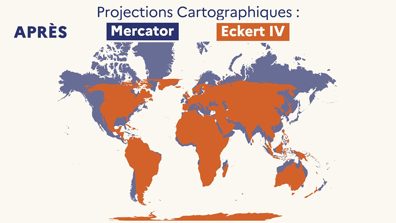
France is redrawing its world map: deeming the Mercator projection misleading, the foreign ministry will drop it in favour of a map that better reflects actual continental sizes, especially Africa.
A shrunken Africa, a Greenland and a northern Russia that seem to stretch into infinity: that is about to disappear from the maps used by French diplomacy.
Foreign Minister Jean-Noël Barrot announced on Friday that his department is abandoning the so-called Mercator projection, which artificially enlarges polar regions and visually downplays the size of equatorial areas. France will now use instead the Eckert IV projection, which reflects the true proportions of the continents more accurately.
As a result, France will appear smaller on the map compared with countries close to the equator, just like the United States or Russia.
'A map is never entirely neutral'
In a speech at the Sorbonne university during the public event "La Fabrique de la diplomatie" or "The making of diplomacy", the French minister said that "the time has come" to "correct" how the world is perceived through maps inherited from 16th-century Western navigators.
In a speech delivered at the Sorbonne for the public event "La Fabrique de la diplomatie", the French minister said that "the time has come" to "correct" how the world is perceived through maps inherited from 16th-century Western navigators.
"A map is never entirely neutral. Take the Mercator projection, the one every one of us has known since childhood. The areas we see on it do not correspond to actual areas: (...) The United States, Russia, China take on a disproportionate visual importance compared with Africa, Latin America or South-East Asia," the French foreign minister said.
Jean-Noël Barrot also cited the example of Greenland, which is roughly the same size as the Democratic Republic of Congo or Algeria, even though it "seems almost as vast" as the entire African continent.
"Changing the map obviously does not change the world. But correcting a representation that distorts it is already an act of truth," he stressed.
The ministry began reducing its use of the Mercator projection in 2021
Meanwhile, French diplomatic maps will not change overnight but the process is already underway, Euronews has learned from a diplomatic source. The ministry began reducing its use of the Mercator projection in 2021, "with the aim of providing a more accurate geographical representation of the world."
The projection has been "gradually phased out" across all public diplomacy websites, the source said.
"The advantages and biases associated with each type of representation are presented at various events attended by the ministry's cartographers," the Quai d'Orsay added, citing the European Heritage Days and the International Geography Festival in Saint-Dié-des-Vosges.
"France will continue this work, prioritising map projections suited to different purposes and providing a more accurate reflection of geographical realities in its diplomatic communications."
French diplomats nevertheless acknowledge that the Mercator projection remains relevant "in a limited number of cases", including regional or local uses around the equatorial zone, as well as for navigation charts.
At the UN, a cartographic victory for Africa
The announcement in Paris comes as, in New York, the world map is also being redrawn. A few hours later, the United Nations General Assembly officially abandoned the Mercator projection in favour of a projection based on the Equal Earth model, created in 2018 and closer to the real proportions of the continents.
The non-binding resolution, entitled "Correcting the map"and sponsored by Togo, was backed by 164 member states. The African Union had already adopted Equal Earth in March, and the text now encourages countries to do the same.
Only the United States voted against, denouncing what it called a "radical ideological project", notably because of a passage in the resolution stating that "correcting cartographic distortions relating to the size of continents constitutes an act of cognitive justice and memorial reparation".
Six countries – Estonia, Georgia, Lithuania, Moldova, Serbia and Ukraine – abstained.
The UN stresses that the resolution does not ban the Mercator projection, "nor does it impose a single map". The resolution "encourages governments, educational institutions, international organisations and technology companies to make use of the Equal Earth projection, or of other so-called 'equal-area' maps that preserve the true proportions of surface areas.
France has therefore joined this movement, but has opted to adopt the Eckert IV projection, created in 1906. It is similar to the Equal Earth projection recommended by the UN, though not identical. Both represent the size of the continents much more faithfully than the Mercator projection, but they differ slightly in the shapes they give to the landmasses.
As the UN points out, Mercator mapping will not disappear altogether. Digital platforms such as Google Maps also currently use a version of this projection.
In French schools, most world maps are still in Mercator. "You can find Eckert or Peters* in some textbooks, but that is very rare," says Grégory, a senior history and geography teacher in Rennes, speaking to Euronews.
It remains to be seen whether the maps used in schools will also follow the shift launched by the foreign ministry.
*another equal-area projection, which provides a better representation of the continents' true surface area – Euronews.
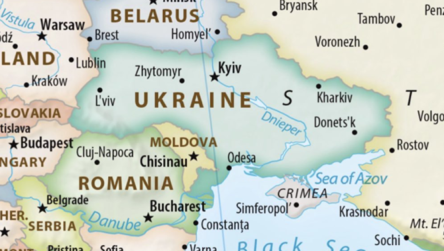
Ukraine abstained from the UN General Assembly resolution adopting a new world map, because the map it endorses shows occupied Crimea in a lighter shade than the rest of Ukraine.
The resolution, tabled by Togo and carried as draft 80/L.104, commits the UN to the Equal Earth projection in place of the Mercator, on the argument that Mercator makes Africa look far smaller than it is. On the version circulated with the vote, Crimea is rendered in a distinctly lighter shade than mainland Ukraine. No comparable marking is applied to Russian-occupied parts of Georgia or Moldova.
A cartographic convention is not usually a diplomatic problem, and the UN has passed a series of resolutions since 2014 treating Crimea as Ukrainian territory under occupation. A UN map that shades it differently sets those two positions against each other in a document every member state has now voted on.
"Such a misinterpretation could open a Pandora's box, effectively facilitating abuses and distortions of the political map of the world," Ukraine's permanent mission to the UN said, adding that it supports correcting the historical distortions of scale but opposes cartographic breaches of the UN Charter and international law, the Kyiv Post reported.
Kira Rudik, the Ukrainian MP who leads the Golos party, put it more bluntly. "Ukraine could not support the UN resolution on a new world map because it depicts occupied Crimea in a way that separates it from Ukraine," she said. "In 2026, the UN should not need a reminder: Crimea is Ukraine."
What has irritated Kyiv most is that its allies did not notice. "Was everyone asleep at the UN Secretariat and at UN missions of European nations?" asked Yaroslav Trofimov, the Ukrainian-born journalist and author. "Nobody in France, UK, Germany, Canada, even Latvia, noticed that they are voting not just for a more accurate map projection of Africa but also for a map showing Crimea detached from Ukraine, in contravention of all previous UN resolutions?"
The resolution passed. Ukraine did not vote against it.

No comments:
Post a Comment