Translator
Tempo.co
Editor
Petir Garda Bhwana
21 January 2024

TEMPO.CO, Bandung - Mount Lewotobi Laki-laki in East Nusa Tenggara (NTT) experienced another eruption on Sunday, January 21, 2024, at around 12:49 WITA (Central Indonesian Time). The eruption was accompanied by an ash column height observed at around 700 meters above the peak or 2,284 meters above sea level.
Acting Head of the Geological Agency, Muhammad Wafid, said that the ash column was observed to be white and gray in color with thick intensity leaning towards the north and northeast. "The maximum amplitude is 47.3 millimeters and the duration is approximately 36 seconds," said Wafid in his statement, Sunday.
Mount Lewotobi is now at Level IV (Alert) status. This volcano, with a height of 1,703 meters above sea level, is currently the most active volcano in Indonesia. Mount Lewotobi has recorded 48 eruptions throughout January 2024.
Wafid appealed to the public and visitors or tourists around Mount Lewotobi not to carry out activities within a 5 kilometer radius of the eruption center. In addition, activities are prohibited within a sectoral radius of 6 kilometers to the north and northeast.
The public is also advised to stay at home if an eruption occurs and ash falls. For residents who want to do activities outside the home, it is recommended to use masks and eye protection.
"Residents must be aware of the potential for cold lava flooding in rivers that originate at the peak of Mount Lewotobi if high intensity rain occurs," said Wafid.
Apart from that, Mount Marapi in West Sumatra also erupted today at around 05:13 WIB (Western Indonesian Time). Based on seismograph recordings, the eruption had a maximum amplitude of 18.4 mm with a duration of 44 seconds.
Mount Marapi is now at Level III (Alert) with a recommendation that the public or tourists are prohibited from carrying out activities within a 4.5 km radius of the eruption center or the Verbeek Crater of Mount Marapi. The mountain with a height of 2,116 meters above sea level has erupted 23 times in January 2024.
"People who live around the valleys, streams and riverbanks that originate at the peak of Mount Marapi should always be aware of the potential threat of lava that can occur, especially during the rainy season," said Wafid.
BY SLAMET RIYADI
January 21, 2024
YOGYAKARTA, Indonesia (AP) — Indonesia’s Mount Merapi erupted Sunday, spreading searing gas clouds and avalanches of lava down its slopes as other active volcanoes flared up across the country, forcing the evacuation of thousands.
On the densely populated island of Java, Merapi unleashed clouds of hot ash and a mixture of rock, and lava that traveled up to 2 kilometers (1.2 miles) down its slopes, said Agus Budi Santoso, the head of Indonesia’s Geological Disaster Technology Research and Development Center. A column of hot clouds blasted 100 meters (about 109 yards) into the air as ash blanketed several villages without casualties, he added.
Merapi is the most active out of more than 120 volcanoes across the country. Sunday’s eruption is the latest since authorities raised its alert level to the second-highest in November 2020 after sensors picked up increasing activity. Residents living on the slopes were advised to stay 7 kilometers (4.3 miles) away from the crater’s mouth and be aware of possible threats from flowing lava.
In 2010, an eruption killed 347 people and displaced 20,000 villagers.
Iceland faces daunting period after lava from volcano destroys homes in fishing town, president says
Indonesia evacuates about 6,500 people on the island of Flores after a volcano spews clouds of ash
A volcano erupts in southwestern Iceland, sending lava flowing toward a nearby settlement
The 2,968-meter (9,737-foot) mountain is about 30 kilometers (18 miles) from Yogyakarta, an ancient center of Javanese culture and the seat of royal dynasties going back centuries. About a quarter million people live within 10 kilometers (6 miles) of the volcano.
Several other active volcanoes also blew up this weekend, prompting authorities to evacuate thousands of residents, said Indonesia’s Center for Volcanology and Geological Disaster Mitigation in a statement released on social media platform X, formerly Twitter. No casualties were reported, it said.
The agency said Mount Lewotobi Laki Laki in East Nusa Tenggara province spewed hot clouds as high as 700 meters (2,300 feet) into the air on Sunday, as more than 6,500 people fled to shelters.
Also on Sunday, Mount Marapi in West Sumatra province erupted again, its third biggest flare-up this month, albeit without discharging lava. About 500 residents living near it were evacuated. Last month, it erupted, killing 23 climbers and injuring several others.
Mount Semeru in East Java province released searing gas clouds and rivers of lava on Saturday, as did Mount Ibu on Halmahera island in North Maluku province which shot a column of hot ashes as high as 1,300 meters (4,265 feet) into the air.
In December 2021, Mount Semeru, the highest volcano on Java island, erupted, leaving 48 people dead and 36 missing.
Indonesia, an archipelago of 270 million people, is prone to earthquakes and volcanic activity because it sits along the “Ring of Fire,” a horseshoe-shaped series of seismic fault lines around the Pacific Ocean.
___
Associated Press writer Niniek Karmini in Jakarta, Indonesia, contributed to this reported.
Experts Confirm: Icelandic Faultline Has Awakened After 800 Years
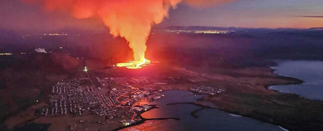
 Eruption on the outskirts of Grindavik, 14 January 2024. (Icelandic Department of Civil Protection and Emergency Management/AFP/Getty Images)
A volcanic eruption that has engulfed homes in an Icelandic fishing port confirms that a long-dormant faultline running under the country has woken up, threatening to belch out lava with little warning for years to come, an expert warned on Tuesday.
Glowing lava swallowed several homes on Sunday at the edge of the town of Grindavik, southwest of the capital Reykjavik.
The fishing town was mostly evacuated due to threat of an eruption last month and the most recent volcanic activity has since eased, authorities in the North Atlantic nation said on Monday.
The island straddles the Mid-Atlantic Ridge, a crack in the ocean floor separating the Eurasian and North American tectonic plates.
Sunday's eruption was the fifth in fewer than three years on the Reykjanes peninsula, which had not previously seen one in centuries.
"After eight centuries of a relative break and a complete cessation of surface activity, we have entered a new episode of plate separation which could last several years – possibly decades," volcanologist Patrick Allard from France's Institut de Physique du Globe de Paris told AFP.
Even before the first of the five eruptions on March 2021, scientists "saw the ground distorting, with magma rising from the depths and seeping into" an area three to 10 kilometers (two to six miles) below the surface, he said.
As that magma bubbled its way upwards through fissures in the Earth, eruptions started to occur.

Ready to erupt
The two most recent eruptions – last month and on Sunday, both threatening Grindavik – were brief and preceded by very little seismic activity.
This shows that the "magma is very close to the surface, ready to erupt", Allard said.
The thinness of the Earth's crust near the faultline under Iceland will help prompt these magma "pressure releases," he said.
But the amount that will actually burst out of the Earth's surface is not expected to be enormous, he added.
The location of this fragile faultline is likely to continue to be a problem.
It poses a threat to the nearby Svartsengi geothermal plant, which provides electricity and water to the 30,000 residents of the Reykjanes peninsula – a tenth of Iceland's population.
The eruptions have also forced the closure of the Blue Lagoon, a popular tourist destination near Grindavik famed for its geothermal spas.
Allard said Grindavik was built on lava flows from 800 years ago, which "raises the question as to (the logic behind) the town's very existence".
And there will probably be little warning before the next eruption.
During the last two eruptions, there were only a "few hours of critical seismic activity" to warn that magma was quickly rising to the surface, he said.
There was also a risk of an underwater eruption, which could create an "explosive phenomenon, releasing more volcanic ash".
It was the huge amount of ash blasted into the atmosphere by the Eyjafjallajokull volcano in 2010 that caused global travel chaos, forcing the cancellation of some 100,000 flights and leaving more than 10 million travellers stranded.
However experts have said that such an extreme event is considered unlikely to happen on the Reykjanes peninsula.